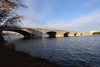
The Arlington Memorial Bridge, often shortened to Memorial Bridge, is a Neoclassical masonry, steel, and stone arch bridge with a central bascule that crosses the Potomac River at Washington, D.C., the capital of the United States. First proposed in 1886, the bridge went unbuilt for decades thanks to political quarrels over whether the bridge should be a memorial, and to whom or what. Traffic problems associated with the dedication of the Tomb of the Unknown Soldier in November 1921 and the desire to build a bridge in time for the bicentennial of the birth of George Washington led to its construction in 1932.
The Rock Creek and Potomac Parkway, informally called the Rock Creek Parkway, is a parkway maintained by the National Park Service as part of Rock Creek Park in Washington, D.C. It runs next to the Potomac River and Rock Creek in a generally north–south direction, carrying four lanes of traffic from the Lincoln Memorial and Arlington Memorial Bridge north to a junction with Beach Drive near Connecticut Avenue at Calvert Street, N.W., just south of the National Zoological Park.

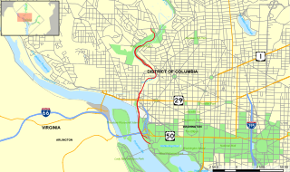
The George Washington Memorial Parkway, colloquially the G.W. Parkway, is a 25-mile-long (40 km) parkway that runs along the south bank of the Potomac River from Mount Vernon, Virginia, northwest to McLean, Virginia, and is maintained by the National Park Service (NPS). It is located almost entirely within Virginia, except for a short portion of the parkway northwest of the Arlington Memorial Bridge that passes over Columbia Island within the District of Columbia.
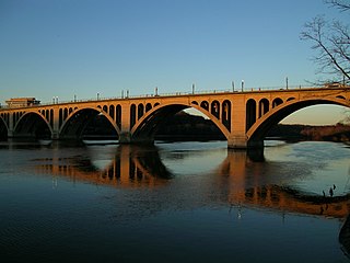
The Francis Scott Key Bridge, more commonly known as the Key Bridge, is a six-lane reinforced concrete arch bridge conveying U.S. Route 29 (US 29) traffic across the Potomac River between the Rosslyn neighborhood of Arlington County, Virginia, and the Georgetown neighborhood of Washington, D.C. Completed in 1923, it is Washington's oldest surviving road bridge across the Potomac River.
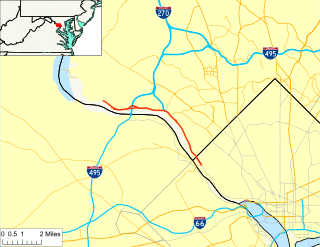
Clara Barton Parkway is an automobile parkway in the U.S. state of Maryland and the District of Columbia. The highway runs 6.8 miles (10.9 km) from MacArthur Boulevard in Carderock, Maryland, east to Canal Road at the Chain Bridge in Washington. Clara Barton Parkway is a two- to four-lane parkway that parallels the Potomac River and the Chesapeake and Ohio Canal (C&O) in southwestern Montgomery County, Maryland, and the far western corner of Washington. The parkway provides access to the communities of Cabin John and Glen Echo and several units of the Chesapeake and Ohio Canal National Historical Park. The Maryland portion of the George Washington Memorial Parkway was constructed from Carderock past Interstate 495 (I-495) to Glen Echo in the early to mid-1960s. The parkway was proposed to continue west to Great Falls and east to Georgetown. However, these proposals never came to fruition and the parkway was extended only to the Chain Bridge in the early 1970s. The Maryland portion of the George Washington Memorial Parkway was renamed in 1989 for Clara Barton, the founder of the American Red Cross, and whose original headquarters is located in Glen Echo.

The Dumbarton Bridge, also known as the Q Street Bridge and the Buffalo Bridge, is a historic masonry arch bridge in Washington, D.C.

The Tidal Basin is a man-made reservoir located between the Potomac River and the Washington Channel in Washington, D.C. It is part of West Potomac Park near the National Mall and is a focal point of the National Cherry Blossom Festival held each spring. The Jefferson Memorial, the Martin Luther King Jr. Memorial, the Franklin Delano Roosevelt Memorial, and the George Mason Memorial are situated adjacent to the Tidal Basin. The basin covers an area of about 107 acres (43 ha) and is 10 feet (3.0 m) deep.

The Duke Ellington Bridge, named after American jazz pianist Duke Ellington, carries Calvert Street NW over Rock Creek in Washington, D.C., United States. It connects 18th Street NW in Adams Morgan with Connecticut Avenue NW in Woodley Park, just north of the Taft Bridge.

The Metropolitan Subdivision is a railroad line owned and operated by CSX Transportation in the District of Columbia and the U.S. state of Maryland. The 53-mile line runs from Washington, D.C., northwest to Weverton, Maryland, along the former Metropolitan Branch of the Baltimore and Ohio Railroad.

The Pennsylvania Avenue Bridge conveys Pennsylvania Avenue across Rock Creek and the adjoining Rock Creek and Potomac Parkway, between the neighborhoods of Georgetown and Foggy Bottom in Northwest Washington, D.C. Pennsylvania Avenue terminates at M Street immediately west of the bridge.

The Boulder Bridge is a historic bridge located in the Washington, D.C. portion of Rock Creek Park, an urban national park listed on the National Register of Historic Places.

The construction of Arlington Memorial Bridge was a seven-year construction project in Washington, D.C., in the United States to construct the Arlington Memorial Bridge across the Potomac River. The bridge was authorized by Congress in February 1925, and was completed in January 1932. As a memorial, its decorative features were extensive and intricate, and resolving the design issues over these details took many years. Tall columns and pylons topped by statuary, Greek Revival temple-like structures, and statue groups were proposed for the ends of the bridge. Carvings and inscriptions were planned for the sides of the bridge, and extensive statuary for the bridge piers.

The Arts of War and The Arts of Peace are bronze, fire-gilded statue groups on Lincoln Memorial Circle in West Potomac Park in Washington, D.C., in the United States. Commissioned in 1929 to complement the plaza constructed on the east side of the Lincoln Memorial as part of the Arlington Memorial Bridge approaches, their completion was delayed until 1939 for budgetary reasons. The models were placed into storage, and the statues not cast until 1950. They were erected in 1951, and repaired in 1974.

The K Street Bridge is a complex of bridges over Rock Creek and the Rock Creek and Potomac Parkway in Washington, D.C. The lower level of the bridge carries the surface street K Street, while the upper level carries the Whitehurst Freeway which terminates and merges into K Street immediately east of the bridge. The central bridge is flanked by two flyover ramps that connect to the nearby terminus of Interstate 66.

The Shoreham Hill Bridge is a bridge carrying the Rock Creek and Potomac Parkway across Rock Creek in Washington, DC. It is the most upstream of three bridges where the Rock Creek and Potomac Parkway switches from one side of the river to the other, the others being the bridge near P Street and the L Street Bridge.

The L Street Bridge is a bridge carrying the Rock Creek and Potomac Parkway over Rock Creek in Washington, D.C. It is the most downstream of three bridges where the Parkway switches from one side of the river to the other, the others being the bridge near P Street and the Shoreham Hill Bridge. Despite its name, the bridge does not carry or cross L Street, but it is adjacent to L Street's western terminus.

The Rock Creek and Potomac Parkway Bridge near P Street is a bridge carrying the Rock Creek and Potomac Parkway across Rock Creek in Washington, DC. It is the middle of three bridges where the Rock Creek and Potomac Parkway switches from one side of the river to the other, the others being the L Street Bridge and the Shoreham Hill Bridge. The bridge is near the site of a historical river ford used by French soldiers traveling to Yorktown in 1781. The bridge is reinforced concrete faced in mica schist.

William Max Haussmann Sr. (1906–1988) originally from Rockledge, Pennsylvania, was an American architect who specialized in historical restoration and preservation for the National Park Service. His 32-year federal career had a number of highlights, as it ranged from restoration work for the Sesquicentennial Celebration of 1931 in Yorktown, Virginia, to the restoration/reconstruction project of Ford's Theatre in the 1960s. He was a member of the American Institute of Architects (AIA).

