
Rock Creek Park is a large urban park that bisects the Northwest quadrant of Washington, D.C. Created by Act of Congress in 1890, the park comprises 1,754 acres, generally along Rock Creek, a tributary of the Potomac River.

The Capital Beltway is a 64-mile (103 km) auxiliary Interstate Highway in the Washington metropolitan area that surrounds Washington, D.C., the capital of the United States, and its inner suburbs in adjacent Maryland and Virginia. It is the basis of the phrase "inside the Beltway", used when referring to issues dealing with U.S. federal government and politics. The highway is signed as Interstate 495 (I-495) for its entire length, and its southern and eastern half runs concurrently with I-95. It was constructed in 1964.

Rock Creek is a tributary of the Potomac River, in the United States, that empties into the Atlantic Ocean via the Chesapeake Bay. The 32.6-mile (52.5 km) creek drains about 76.5 square miles (198 km2). Its final quarter-mile is affected by tides.

Colonial Parkway is a 23-mile (37 km) scenic parkway linking the three points of Virginia's Historic Triangle, Jamestown, Williamsburg, and Yorktown. It is part of the National Park Service's Colonial National Historical Park. Virginia's official state classification for the parkway is State Route 90003. With portions built between 1930 and 1957, it links the three communities via a roadway shielded from views of commercial development. The roadway is toll-free, is free of semi trucks, and has speed limits of around 35 to 45 mph. As a National Scenic Byway and All-American Road, it is also popular with tourists due to the James River and York River ends of the parkway.
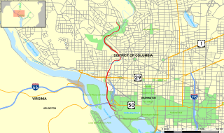
The Rock Creek and Potomac Parkway, informally called the Rock Creek Parkway, is a parkway maintained by the National Park Service as part of Rock Creek Park in Washington, D.C. It runs next to the Potomac River and Rock Creek in a generally north–south direction, carrying four lanes of traffic from the Lincoln Memorial and Arlington Memorial Bridge north to a junction with Beach Drive near Connecticut Avenue at Calvert Street, N.W., just south of the National Zoological Park. During rush hours, the parkway is converted to one-way traffic corresponding to the peak direction of travel: southbound in the morning and northbound in the afternoon.
The George Washington Memorial Parkway, colloquially the G.W. Parkway, is a 25-mile-long (40 km) limited-access parkway that runs along the south bank of the Potomac River from Mount Vernon, Virginia, northwest to McLean, Virginia, and is maintained by the National Park Service (NPS). It is located almost entirely in Northern Virginia, except for a short portion of the parkway northwest of the Arlington Memorial Bridge that passes over Columbia Island in Washington, D.C.
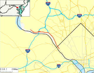
The Clara Barton Parkway is a parkway in the U.S. state of Maryland and the District of Columbia. The highway runs 6.8 miles (10.9 km) from MacArthur Boulevard in Carderock, Maryland, east to Canal Road at the Chain Bridge in Washington. The Clara Barton Parkway is a two- to four-lane parkway that parallels the Potomac River and the Chesapeake and Ohio Canal (C&O) in southwestern Montgomery County, Maryland, and the far western corner of Washington. The parkway provides access to the communities of Cabin John and Glen Echo and several units of the Chesapeake and Ohio Canal National Historical Park. The Maryland portion of the George Washington Memorial Parkway was constructed from Carderock past Interstate 495 (I-495) to Glen Echo in the early to mid-1960s. The parkway was proposed to continue west to Great Falls and east to Georgetown. However, these proposals never came to fruition and the parkway was extended only to the Chain Bridge in the early 1970s. The Maryland portion of the George Washington Memorial Parkway was renamed in 1989 for Clara Barton, the founder of the American Red Cross, and whose original headquarters is located in Glen Echo.

Connecticut Avenue is a major thoroughfare in the Northwest quadrant of Washington, D.C., and suburban Montgomery County, Maryland. It is one of the diagonal avenues radiating from the White House, and the segment south of Florida Avenue was one of the original streets in Pierre (Peter) Charles L'Enfant's plan for Washington. A five-mile segment north of Rock Creek was built in the 1890s by a real-estate developer.

The Suitland Parkway is a limited-access parkway in Washington, D.C., and Prince George's County, Maryland, administered and maintained by the U.S. National Park Service (NPS), National Capital Parks-East. The road has partial controlled access with a combination of interchanges and at-grade intersections, but without property access for neighboring land-owners. Conceived in 1937, it was built during World War II to provide a road connection between military facilities in the Washington, D.C. metropolitan area and is named after Suitland, Maryland. It fully opened on December 9, 1944 as the Camp Springs highway, so called because it connected Camp Springs in Prince George's County with Bolling Air Force Base. However one lane of the highway was opened in mid-October 1944.

The Taft Bridge is a historic bridge located in the Northwest quadrant of Washington, D.C. It carries Connecticut Avenue over the Rock Creek gorge, including Rock Creek and the Rock Creek and Potomac Parkway, connecting the neighborhoods of Woodley Park and Kalorama. It is named after former United States president and Supreme Court Chief Justice William Howard Taft, and sits to the southwest of the Duke Ellington Bridge.

The Dumbarton Bridge, also known as the Q Street Bridge and the Buffalo Bridge, is a historic masonry arch bridge in Washington, D.C.

Maryland Route 190 is a state highway in the U.S. state of Maryland. Known as River Road, the highway runs 15.88 miles (25.56 km) from MD 112 near Seneca east to Western Avenue at the District of Columbia boundary in Bethesda. MD 190 parallels the Potomac River through the affluent southwestern Montgomery County communities of Potomac and Bethesda and connects those suburbs with Interstate 495 (I-495). River Road was paved from Washington, D.C. west through part of Bethesda in the early 1910s. A second section of MD 190 was constructed through Potomac in the mid-1920s. The Bethesda and Potomac portions of the route were unified in the late 1920s. MD 190 was extended west toward Seneca in two steps in 1950 and the early 1970s. The highway was expanded to a four-lane divided highway through Bethesda in the early 1960s.

The M Street Bridge, also known as the M Street Overpass, carries M Street across Rock Creek and the Rock Creek and Potomac Parkway. It lies between the neighborhoods of Georgetown and Foggy Bottom in Northwest Washington, D.C. The non-arched design of the bridge contrasts with that of all the other bridges rising over the parkway.

The Pennsylvania Avenue Bridge conveys Pennsylvania Avenue across Rock Creek and the adjoining Rock Creek and Potomac Parkway, between the neighborhoods of Georgetown and Foggy Bottom in Northwest Washington, D.C. Pennsylvania Avenue terminates at M Street immediately west of the bridge.

The Boulder Bridge is a historic bridge located in the Washington, D.C. portion of Rock Creek Park, an urban national park listed on the National Register of Historic Places.

The B & O Railroad Potomac River Crossing is a 15-acre (6.1 ha) historic site where a set of railroad bridges, originally built by the Baltimore and Ohio Railroad, span the Potomac River between Sandy Hook, Maryland and Harpers Ferry, West Virginia. The site was added to the National Register of Historic Places on February 14, 1978, for its significance in commerce, engineering, industry, invention, and transportation.

The K Street Bridge is a complex of bridges over Rock Creek and the Rock Creek and Potomac Parkway in Washington, D.C. The lower level of the bridge carries the surface street K Street, while the upper level carries the Whitehurst Freeway which terminates and merges into K Street immediately east of the bridge. The central bridge is flanked by two flyover ramps that connect to the nearby terminus of Interstate 66.

The Shoreham Hill Bridge is a bridge carrying the Rock Creek and Potomac Parkway across Rock Creek in Washington, DC. It is the most upstream of three bridges where the Rock Creek and Potomac Parkway switches from one side of the river to the other, the others being the bridge near P Street and the L Street Bridge.

The L Street Bridge is a bridge carrying the Rock Creek and Potomac Parkway over Rock Creek in Washington, D.C. It is the most downstream of three bridges where the Parkway switches from one side of the river to the other, the others being the bridge near P Street and the Shoreham Hill Bridge. Despite its name, the bridge does not carry or cross L Street, but it is adjacent to L Street's western terminus.

The Rock Creek and Potomac Parkway Bridge near P Street is a bridge carrying the Rock Creek and Potomac Parkway across Rock Creek in Washington, DC. It is the middle of three bridges where the Rock Creek and Potomac Parkway switches from one side of the river to the other, the others being the L Street Bridge and the Shoreham Hill Bridge. The bridge is near the site of a historical river ford used by French soldiers traveling to Yorktown in 1781. The bridge is reinforced concrete faced in mica schist.


