
Rock Creek Park is a large urban park that bisects the Northwest quadrant of Washington, D.C. The park was created by an Act of Congress in 1890 and today is administered by the National Park Service. In addition to the park proper, the Rock Creek administrative unit of the National Park Service administers various other federally owned properties in the District of Columbia located to the north and west of the National Mall, including Meridian Hill Park on 16th Street, N.W., the Old Stone House in Georgetown, and certain of the Fort Circle Parks, a series of batteries and forts encircling the District of Columbia for its defense during the U.S. Civil War.
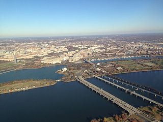
The 14th Street bridges refers to the three bridges near each other that cross the Potomac River, connecting Arlington, Virginia and Washington, D.C.. Sometimes the two nearby rail bridges are included as part of the 14th Street bridge complex. A major gateway for automotive, bicycle and rail traffic, the bridge complex is named for 14th Street, which feeds automotive traffic into it on the D.C. end.
The Rock Creek and Potomac Parkway, often known simply as the Rock Creek Parkway, is a parkway maintained by the National Park Service as part of Rock Creek Park in Washington, D.C. It runs next to the Potomac River and Rock Creek in a generally north–south direction, carrying four lanes of traffic from the Lincoln Memorial and Arlington Memorial Bridge north to a junction with Beach Drive near Connecticut Avenue at Calvert Street, N.W., just south of the National Zoological Park.
The George Washington Memorial Parkway, colloquially the G.W. Parkway, is a 25-mile-long (40 km) parkway that runs along the south bank of the Potomac River from Mount Vernon, Virginia, northwest to McLean, Virginia, and is maintained by the National Park Service (NPS). It is located almost entirely within Virginia, except for a short portion of the parkway northwest of the Arlington Memorial Bridge that passes over Columbia Island within the District of Columbia.

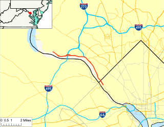
The Theodore Roosevelt Bridge is a bridge crossing the Potomac River which connects Washington, D.C., with the Commonwealth of Virginia. The bridge crosses over Theodore Roosevelt Island, and carries Interstate 66/U.S. Route 50. The center lane in the bridge is reversible; the middle barrier is moved with a barrier transfer machine. It’s operated eastbound during the morning rush hour from 6-11 am. The bridge is named in honor of Theodore Roosevelt, the 26th President of the United States.
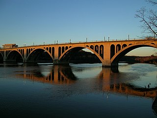
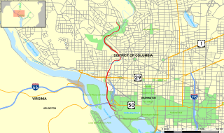
The Francis Scott Key Bridge, more commonly known as the Key Bridge, is a six-lane reinforced concrete arch bridge conveying U.S. Route 29 (US 29) traffic across the Potomac River between the Rosslyn neighborhood of Arlington County, Virginia, and the Georgetown neighborhood of Washington, D.C. Completed in 1923, it is Washington's oldest surviving road bridge across the Potomac River.
Clara Barton Parkway is an automobile parkway in the U.S. state of Maryland and the District of Columbia. The highway runs 6.8 miles (10.9 km) from MacArthur Boulevard in Carderock, Maryland, east to Canal Road at the Chain Bridge in Washington. Clara Barton Parkway is a two- to four-lane parkway that parallels the Potomac River in southwestern Montgomery County, Maryland, and the far western corner of Washington. The parkway provides access to the communities of Cabin John and Glen Echo and several units of the Chesapeake and Ohio Canal National Historical Park. The Maryland portion of the George Washington Memorial Parkway was constructed from Carderock past Interstate 495 (I-495) to Glen Echo in the early to mid-1960s. The parkway was proposed to continue west to Great Falls and east to Georgetown. However, these proposals never came to fruition and the parkway was extended only to the Chain Bridge in the early 1970s. The Maryland portion of the George Washington Memorial Parkway was renamed for Clara Barton, the founder of the American Red Cross, in 1989.

The Dumbarton Bridge, also known as the Q Street Bridge and the Buffalo Bridge, is a historic masonry arch bridge in Washington, D.C.

Little Hunting Creek is a 3.6-mile-long (5.8 km) primarily tidal tributary of the Potomac River located in Fairfax County, Virginia, not to be confused with Hunting Creek farther north. A stone-arch bridge, completed in 1931, carries traffic on the George Washington Memorial Parkway across the narrow mouth of the creek, located 96.6 miles (155.5 km) upriver from the mouth of the Potomac. The Washington family built its Mount Vernon plantation on the Potomac River along both banks of Little Hunting Creek during colonial times. The creek is bordered by residential communities in addition to the Mount Vernon property. It is a popular location for recreational fishing, and much of the wildlife characteristic of the tidal Potomac wetlands can be spotted there.

The P Street Bridge or Lauzun's Legion Bridge is a 336-foot (102 m) concrete arch bridge that conveys P Street across Rock Creek and Rock Creek Park between the Georgetown and Dupont Circle neighborhoods of Northwest Washington, D.C. The first bridge at this site was constructed in 1855 and was replaced in 1935 by the current structure.

The M Street Bridge, also known as the M Street Overpass, carries M Street across Rock Creek and the Rock Creek and Potomac Parkway. It lies between the neighborhoods of Georgetown and Foggy Bottom in Northwest Washington, D.C. The non-arched design of the bridge contrasts with that of all the other bridges rising over the parkway.

The Charles C. Glover Memorial Bridge or Massachusetts Avenue Bridge in Northwest Washington, D.C. conveys Massachusetts Avenue over Rock Creek and Rock Creek Park. The concrete arch bridge was constructed in 1939–41 and has a length of 386.2 feet (117.7 m).

The Pennsylvania Avenue Bridge conveys Pennsylvania Avenue across Rock Creek and the adjoining Rock Creek and Potomac Parkway, between the neighborhoods of Georgetown and Foggy Bottom in Northwest Washington, D.C. Pennsylvania Avenue terminates at M Street immediately west of the bridge.

The Boulder Bridge is a historic bridge located in the Washington, D.C. portion of Rock Creek Park, an urban national park listed on the National Register of Historic Places.

The construction of Arlington Memorial Bridge was a seven-year construction project in Washington, D.C., in the United States to construct the Arlington Memorial Bridge across the Potomac River. The bridge was authorized by Congress in February 1925, and was completed in January 1932. As a memorial, its decorative features were extensive and intricate, and resolving the design issues over these details took many years. Tall columns and pylons topped by statuary, Greek Revival temple-like structures, and statue groups were proposed for the ends of the bridge. Carvings and inscriptions were planned for the sides of the bridge, and extensive statuary for the bridge piers.

The K Street Bridge is a complex of bridges over Rock Creek and the Rock Creek and Potomac Parkway in Washington, D.C. The lower level of the bridge carries the surface street K Street, while the upper level carries the Whitehurst Freeway which terminates and merges into K Street immediately east of the bridge. The central bridge is flanked by two flyover ramps that connect to the nearby terminus of Interstate 66.

The L Street Bridge is a bridge carrying the Rock Creek and Potomac Parkway over Rock Creek in Washington, D.C. It is the most downstream of three bridges where the Parkway switches from one side of the river to the other, the others being the bridge near P Street and the Shoreham Hill Bridge. Despite its name, the bridge does not carry or cross L Street, but it is adjacent to L Street's western terminus.

The Rock Creek and Potomac Parkway Bridge near P Street is a bridge carrying the Rock Creek and Potomac Parkway across Rock Creek in Washington, DC. It is the middle of three bridges where the Rock Creek and Potomac Parkway switches from one side of the river to the other, the others being the L Street Bridge and the Shoreham Hill Bridge. The bridge is near the site of a historical river ford used by French soldiers traveling to Yorktown in 1781. The bridge is reinforced concrete faced in mica schist.

The Rock Creek Trails are a series of trails through the Rock Creek valley and along the Potomac River in Washington, DC and Montgomery County, MD. The main route extends 22 miles from Lake Needwood in Maryland to the Inlet Bridge in Washington, DC, with a loop in the north part of Rock Creek Park and other trails through the Klingle Valley, Turkey Branch Valley and along the North Branch of Rock Creek. There are three separate trails that make up the main Rock Creek Trail route and others that connect to it. Along the Potomac River from Arlington Memorial Bridge to Rock Creek is a section sometimes called the Shoreline Trail.

