Pennsylvania Avenue

Last updated

Pennsylvania Avenue
OldPostOfficePennAve.jpg
Pennsylvania Avenue with the U.S. Capitol in the background
Length35.1 mi (56.5 km)
Location Washington, D.C. and Prince George's County, Maryland, U.S.

Pennsylvania Avenue is a primarily diagonal street in Washington, D.C. that connects the United States Capitol with the White House and then crosses northwest Washington, D.C. to Georgetown. Traveling through southeast Washington from the Capitol, it enters Prince George's County, Maryland, and becomes MD Route 4 (MD 4) and then MD Route 717 in Upper Marlboro, and finally Stephanie Roper Highway.

Contents

The section of the avenue between the White House (which is sometimes referred to by its address, "1600 Pennsylvania Avenue") and Congress forms the basis for the Pennsylvania Avenue National Historic Site and is sometimes referred to as "America's Main Street"; [1] it is the location of official parades and processions, and periodic protest marches. Pennsylvania Avenue is an important commuter road and is part of the National Highway System. [2] [3]

Route

A 1942 photo of Pennsylvania Avenue and 14th Street N.W. in front of the U.S. Department of Commerce DC Route 4.jpg
A 1942 photo of Pennsylvania Avenue and 14th Street N.W. in front of the U.S. Department of Commerce
A Pennsylvania Avenue N.W. street sign near the White House Pennsylvania Avenue NW - DC street sign.jpg
A Pennsylvania Avenue N.W. street sign near the White House

The avenue runs for 5.8 miles (9.3 km) in Washington, D.C., but the 1.2 miles (1.9 km) of Pennsylvania Avenue from the White House to the United States Capitol building is far and away the most famed section of the avenue. It continues within the city for 3.5 miles (5.6 km), from the southeast corner of the Capitol grounds through the Capitol Hill neighborhood, and over the Anacostia River on the John Philip Sousa Bridge. Crossing most of Prince George's County, Maryland, it ends 9.5 miles (15.3 km) from the Washington, D.C. border in Maryland at the junction with MD 717 in Upper Marlboro, where the name changes to Stephanie Roper Highway, for a total length of 15.3 miles (24.6 km). Stephanie Roper Highway used to be Pennsylvania Avenue, but was renamed in 2012. In addition to its street names, in Maryland it is designated as Maryland Route 4.

Northwest of the White House, Pennsylvania Avenue runs for 1.4 miles (2.3 km) to its end at M Street N.W. in Georgetown, just beyond the Pennsylvania Avenue Bridge over Rock Creek. From 1862 to 1962, streetcars ran the length of the avenue from Georgetown to the Anacostia River.

History

18th century

An illustration of Pennsylvania Avenue and the U.S. Capitol before it was burned down by the British on August 24, 1814, during the War of 1812 U.S. Capitol and Pennsylvania Avenue before 1814 LCCN00522050.jpg
An illustration of Pennsylvania Avenue and the U.S. Capitol before it was burned down by the British on August 24, 1814, during the War of 1812
The intersection of 11th Street and Pennsylvania Avenue, N.W., in 1921 11th & Pennsylvania Avenue, NW - Washington, D.C..jpg
The intersection of 11th Street and Pennsylvania Avenue, N.W., in 1921
A southeast view down Pennsylvania Avenue towards the Old Post Office Pavilion and U.S. Capitol Pennsylvania Ave - Old Post Office to the Capitol at Night.jpg
A southeast view down Pennsylvania Avenue towards the Old Post Office Pavilion and U.S. Capitol

Although Pennsylvania Avenue extends six miles (10 km) in Washington, D.C., the expanse between the White House and the United States Capitol constitutes the ceremonial heart of the nation. George Washington called this stretch of Pennsylvania Avenue "most magnificent and most convenient". [4]

The first reference to the street as Pennsylvania Avenue was in a 1791 letter from Thomas Jefferson. One theory behind the avenue's name is that it was named for Pennsylvania as consolation for moving the capital from Philadelphia in 1800 and in recognition of Pennsylvania's historical significance in the nation's founding. [5] Both Jefferson and Washington considered Pennsylvania Avenue an important feature of the new capital. After inspecting L'Enfant's plan, President Washington referred to the thoroughfare as a "grand avenue".[ citation needed ] Jefferson concurred, and while the "grand avenue" was little more than a wide dirt road ridiculed as "The Great Serbonian Bog", he planted it with rows of fast-growing Lombardy poplars.[ citation needed ]

Pennsylvania Avenue was designed by Pierre (Peter) Charles L'Enfant, and it was one of the earliest streets constructed in the city.

19th century

In 1832, in an effort to tame dust and dirt on Pennsylvania Avenue, it was paved using the macadam method. But over the years, other pavement methods were trialed on the avenue: cobblestones in 1849 followed by Belgian blocks and then, in 1871, wooden blocks.

In 1876, as part of an initiative begun by President Ulysses S. Grant to see Washington City's streets improved, Pennsylvania Avenue was paved with asphalt by Civil War veteran William Averell [6] using Trinidad and Guanoco lakes asphalt. [7]

20th century

In the early 1900s, the French ambassador to the U.S., Jean Jules Jusserand, popularized the use of L'Enfant's birth name, "Pierre Charles L'Enfant". [8]

Pennsylvania Avenue once provided an unobstructed view between the White House and the Capitol. The construction of an expansion to the Treasury Building blocked this view, and supposedly President Andrew Jackson did this on purpose. Relations between the president and Congress were strained, and Jackson did not want to see the Capitol out his window, [9] though in reality the Treasury Building was simply built on what was cheap government land.

In 1959, Pennsylvania Avenue was extended from the Washington, D.C. border with Maryland to Dower House Road in Upper Marlboro, Maryland. [10]

On September 30, 1965, portions of the avenue and surrounding area were designated the Pennsylvania Avenue National Historic Site. The National Park Service administers this area which includes the United States Navy Memorial, Old Post Office Tower, and Pershing Park. [5] After the Great Depression in the 1930s and the move of affluent families to suburbs in the 1950s, Pennsylvania Avenue became increasingly blighted. John F. Kennedy and Lyndon B. Johnson tried to redevelop the street as part of the New Frontier and Great Society reforms, but the avenue further declined after the 1968 Washington, D.C., riots in the aftermath of the assassination of Martin Luther King Jr. [11]

In 1972, Congress created the Pennsylvania Avenue Development Corporation (PADC) to rehabilitate the street between the Capitol and the White House, an area seen as blighted. The new organization was given the mandate of developing Pennsylvania Avenue "in a manner suitable to its ceremonial, physical, and historic relationship to the legislative and executive branches of the federal government". [5]

In the 1980s, renovations were made to the Willard Hotel, the Old Post Office, and Washington Union Station, each located on or adjacent to Pennsylvania Avenue. [11]

21st century

In 2010, the District of Columbia designated Pennsylvania Avenue from the southwestern terminus of John Philip Sousa Bridge to the Maryland state line to be a "D.C. Great Street". The city spent $430 million to beautify the street and improve the roadway. [12]

Parades and protests
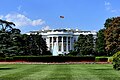
The White House is at 1600 Pennsylvania Avenue N.W. White House 06.02.08.jpg
The White House is at 1600 Pennsylvania Avenue N.W.
The crossroads of K Street and Pennsylvania Avenue in the Foggy Bottom neighborhood Pennsylvania Avenue and K Street.JPG
The crossroads of K Street and Pennsylvania Avenue in the Foggy Bottom neighborhood

Presidential inaugurations

Ever since an impromptu procession formed around Jefferson's second inauguration, every U.S. president except Ronald Reagan in his second inauguration in January 1985 has paraded down Pennsylvania Avenue after taking the oath of office. Reagan paraded up the avenue for his first inauguration in January 1981 but not following his second inauguration in 1985 because freezing temperatures and high winds made it dangerous.

Presidential funeral processions

From William Henry Harrison to Gerald Ford, the funeral corteges of seven of the eight presidents who died in office and two former presidents followed this route. Franklin Roosevelt was the only president who died in office whose cortege did not follow this route.

Abraham Lincoln's funeral cortege solemnly proceeded along Pennsylvania Avenue in 1865; only weeks later, the end of the American Civil War was celebrated with the Grand Review of the Armies when the Army of the Potomac paraded more joyously along the avenue. The funeral processions of both Lyndon B. Johnson and Ford funeral corteges proceeded down Pennsylvania Avenue. For Lyndon Johnson, the cortege was along Pennsylvania Avenue from U.S. Capitol to National City Christian Church, where he often worshiped and where his funeral was held. Ford's funeral went up Pennsylvania Avenue, pausing at the White House en route to Washington National Cathedral, where his funeral was held.

Protests and celebrations

In addition to serving as a location for official functions, Pennsylvania Avenue is a traditional parade and protest route of ordinary citizens. During the depression of the 1890s, Jacob Coxey marched 500 supporters down Pennsylvania Avenue to the U.S. Capitol to demand federal aid for the unemployed. Similarly, on the eve of Woodrow Wilson's 1913 inauguration, Alice Paul masterminded a parade, the Woman Suffrage Procession, highlighting the women's suffrage movement. In July 1932, a contingent of the Bonus Expeditionary Force carried flags up Pennsylvania Avenue to the White House, where they formed picket lines.

Pennsylvania Avenue also has served as a background for more lighthearted celebrations, including a series of Shriner's parades in the 1920s and 1930s. Thomas and Concepcion Picciotto are the founders of the White House Peace Vigil, the longest-running anti-nuclear peace vigil in the nation at Lafayette Square on the 1600 block of Pennsylvania Avenue. [13] [14]

Security measures

After the Oklahoma City bombing in 1995, the Secret Service closed the portion of Pennsylvania Avenue in front of the White House to all vehicular traffic. Pedestrian and bicycle traffic, however, was still permitted on the sidewalk. After the September 11 attacks, all traffic in front of the White House was prohibited, and traffic near the White House is redirected to H Street or Constitution Avenue, both of which eventually link back with Pennsylvania Avenue.

In 2002, the National Capital Planning Commission invited several prominent landscape architects to submit proposals for the redesign of Pennsylvania Avenue at the White House, with the intention that the security measures would be woven into an overall plan for the precinct and a more welcoming public space might be created. The winning entry by a firm run by Michael Van Valkenburgh proposed a very simple approach to planting, paving, and the integration of required security steps. Construction was completed in 2004. [15]

Sites of interest

From east to west:

The National Theatre and Warner Theatre use Pennsylvania Avenue mailing addresses, although the theaters are nearby on E Street and 13th Street respectively.

Transit service

Storefronts on Pennsylvania Avenue in the city's Capitol Hill neighborhood Capitol Hill, DC - Pennsylvania Avenue 2.JPG
Storefronts on Pennsylvania Avenue in the city's Capitol Hill neighborhood
A parade on Pennsylvania Avenue, N.W., during President Obama's second inauguration on January 21, 2013 Participants in the 57th presidential inauguration parade make their way down Pennsylvania Avenue in Washington, D.C 130121-M-TF630-095.jpg
A parade on Pennsylvania Avenue, N.W., during President Obama's second inauguration on January 21, 2013
Protesters on Pennsylvania Avenue during the 2007 protests against the Iraq War Marching towards the Capital - September 15, 2007.jpg
Protesters on Pennsylvania Avenue during the 2007 protests against the Iraq War

Metrobus

The following Metrobus routes travel along the street (listed from west to east):

DC Circulator

The DC Circulator travels along the street:

MTA Commuter Bus

The following MTA Maryland Commuter Bus routes travel along the street:

Bus

The following routes of TheBus serve Pennsylvania Ave. in Prince George's County:

Washington Metro

The following Washington Metro stations have entrances located near Pennsylvania Avenue:

Related Research Articles

<span class="mw-page-title-main">14th Street (Washington, D.C.)</span> Street in northwest and southwest quadrants of Washington, D.C., US

14th Street NW/SW is a street in Northwest and Southwest quadrants of Washington, D.C., located 1.25 miles (2.01 km) west of the U.S. Capitol. It runs from the 14th Street Bridge north to Eastern Avenue.

<span class="mw-page-title-main">Constitution Avenue</span> Street in the city of Washington, D.C.

Constitution Avenue is a major east–west street in the northwest and northeast quadrants of the city of Washington, D.C., in the United States. It was originally known as B Street, and its western section was greatly lengthened and widened between 1925 and 1933. It received its current name on February 26, 1931, though it was almost named Jefferson Avenue in honor of Thomas Jefferson.

<span class="mw-page-title-main">New York Avenue (Washington, D.C.)</span>

New York Avenue is a diagonal avenue radiating northeast from the White House in Washington, D.C. to the border with Maryland. It is a major east–west route in the city's Northwest and Northeast quadrants and connects downtown with points east and north of the city via Cheverly, Maryland, the John Hanson Highway, the Baltimore–Washington Parkway, and eventually, Interstate 95.

<span class="mw-page-title-main">Outdoor sculpture in Washington, D.C.</span>

There are many outdoor sculptures in Washington, D.C. In addition to the capital's most famous monuments and memorials, many figures recognized as national heroes have been posthumously awarded with his or her own statue in a park or public square. Some figures appear on several statues: Abraham Lincoln, for example, has at least three likenesses, including those at the Lincoln Memorial, in Lincoln Park, and the old Superior Court of the District of Columbia. A number of international figures, such as Mohandas Gandhi, have also been immortalized with statues. The Statue of Freedom is a 19½-foot tall allegorical statue that rests atop the United States Capitol dome.

<span class="mw-page-title-main">Massachusetts Avenue (Washington, D.C.)</span> Major road in Washington, D.C., U.S.

Massachusetts Avenue is a major diagonal transverse road in Washington, D.C., and the Massachusetts Avenue Historic District is a historic district that includes part of it.

<span class="mw-page-title-main">Wisconsin Avenue</span> Thoroughfare in Washington, D.C. and its suburbs

Wisconsin Avenue is a major thoroughfare in Washington, D.C., and its Maryland suburbs. The southern terminus begins in Georgetown just north of the Potomac River, at an intersection with K Street under the elevated Whitehurst Freeway. Wisconsin Avenue ends just north of Bethesda, Maryland—though the road designated as Maryland Route 355 continues north for miles under the name of Rockville Pike.

<span class="mw-page-title-main">Independence Avenue (Washington, D.C.)</span>

Independence Avenue is a major east-west street in the southwest and southeast quadrants of the city of Washington, D.C., in the United States, running just south of the United States Capitol. Originally named South B Street, Independence Avenue SW was constructed between 1791 and 1823. Independence Avenue SE was constructed in pieces as residential development occurred east of the United States Capitol and east of the Anacostia River. Independence Avenue SW received its current name after Congress renamed the street in legislation approved on April 13, 1934. Independence Avenue SW originally had its western terminus at 14th Street SW, but was extended west to Ohio Drive SW between 1941 and 1942. The government of the District of Columbia renamed the portion of the road in the southeast quadrant of the city in 1950.

<span class="mw-page-title-main">Pennsylvania Avenue National Historic Site</span> National Historic Site of the United States in Washington, D.C.

Pennsylvania Avenue National Historic Site is a National Historic Site in the city of Washington, D.C. Established on September 30, 1965, the site is roughly bounded by Constitution Avenue, 15th Street NW, F Street NW, and 3rd Street NW. The historic district includes a number of culturally, aesthetically, and historically significant structures and places, including Pennsylvania Avenue NW from the White House to the United States Capitol, the Treasury Building, Freedom Plaza, Federal Triangle, Ford's Theatre, the Old Patent Office Building, the Old Pension Office Building, which now houses the National Building Museum, Judiciary Square, and the Peace Monument.

<span class="mw-page-title-main">Rhode Island Avenue</span>

Rhode Island Avenue is a diagonal avenue in the Northwest and Northeast quadrants of Washington, D.C., and the capital's inner suburbs in Prince George's County, Maryland. Paralleling New York Avenue, Rhode Island Avenue was one of the original streets in Pierre L'Enfant's plan for the capital. It became a major commuter route, carrying U.S. Route 1 traffic into the city from Prince George's County.

<span class="mw-page-title-main">Streetcars in Washington, D.C.</span> Streetcars that existed in Washington until 1962

Streetcars in Washington, D.C. transported people across the city and region from 1862 until 1962.

<span class="mw-page-title-main">South Capitol Street</span>

South Capitol Street is a major street dividing the southeast and southwest quadrants of Washington, D.C., in the United States. It runs south from the United States Capitol to the D.C.–Maryland line, intersecting with Southern Avenue. After it enters Maryland, the street becomes Indian Head Highway at the Eastover Shopping Center, a terminal or transfer point of many bus routes.

<span class="mw-page-title-main">M Street (Washington, D.C.)</span> Four streets of the same name in Washington, D.C.

The name "M Street" refers to two major roads in the United States capital of Washington, D.C. Because of the Cartesian coordinate system used to name streets in Washington, the name "M Street" can be used to refer to any east-west street located twelve blocks north or south of the dome of the United States Capitol. Thus, in all four quadrants of the city there are streets called "M Street", which are disambiguated by quadrant designations, namely, M Street NW, NE, SW, and SE.

<span class="mw-page-title-main">7th Street (Washington, D.C.)</span>

There are two north–south arteries in Washington, D.C. named 7th Street that are differentiated by the quadrants of the city in which they are located.

<span class="mw-page-title-main">Barney Circle</span> Neighborhood in the United States

Barney Circle is a small residential neighborhood located between the west bank of the Anacostia River and the eastern edge of Capitol Hill in southeast Washington, D.C., in the United States. The neighborhood is characterized by its sense of community, activism, walkability, and historic feel. The neighborhood's name derives from the eponymous former traffic circle Pennsylvania Avenue SE just before it crosses the John Philip Sousa Bridge over the Anacostia. The traffic circle is named for Commodore Joshua Barney, Commander of the Chesapeake Bay Flotilla in the War of 1812.

The streets and highways of Washington, D.C., form the core of the surface transportation infrastructure in Washington, D.C., the federal capital of the United States. Given that it is a planned city, the city's streets follow a distinctive layout and addressing scheme. There are 1,500 miles (2,400 km) of public roads in the city, of which 1,392 miles (2,240 km) are owned and maintained by city government.

<span class="mw-page-title-main">New Hampshire Avenue</span> Diagonal street in Washington, D.C.

New Hampshire Avenue is a diagonal street in Washington, D.C., beginning at the Kennedy Center and extending northeast for about 5 miles (8 km) and then continuing into Maryland where it is designated Maryland Route 650. New Hampshire Avenue, however, is not contiguous. It stops at 15th and W Streets NW and resumes again on the other side of Columbia Heights at Park Road NW, a few blocks from Georgia Avenue. New Hampshire Avenue passes through several Washington neighborhoods including Foggy Bottom, Dupont Circle, Petworth and Lamond-Riggs.

<span class="mw-page-title-main">Downtown (Washington, D.C.)</span> United States historic place

Downtown is the central business district of Washington, D.C., located in Northwest D.C. It is the third largest central business district in the United States. The "Traditional Downtown" has been defined as an area roughly between Union Station in the east and 16th Street NW in the west, and between the National Mall on the south and Massachusetts Avenue on the north, including Penn Quarter. However, nowadays, Downtown D.C. usually refers to a larger area, as the DC Office of Planning states:

…most residents, workers, and visitors think of Downtown in a broader sense — including areas as far north as Dupont Circle, as far west as Foggy Bottom, and as far east as Capitol Hill. Only about half of the central city workforce is located within the city’s traditional Downtown.

<span class="mw-page-title-main">Washington and Georgetown Railroad</span> American streetcar company

The Washington and Georgetown Railroad Company was the first streetcar company to operate in Washington, D.C., United States. It was incorporated and started operations in 1862, using horse-drawn cars on tracks between Georgetown and the Navy Yard. Two additional lines ran on 7th Street NW/SW and 14th Street NW. In 1890, it switched to cable cars. On September 21, 1895, the company was purchased by the Rock Creek Railway and the two formed the Capital Traction Company.

<span class="mw-page-title-main">Pennsylvania Avenue Line (Washington, D.C.)</span> Daily Metrobus route in Washington, D.C., United States

The Pennsylvania Avenue Line, designated Routes 32 and 36, is a daily Metrobus route in Washington, D.C., Operating between the Southern Avenue station or Naylor Road station of the Green Line of the Washington Metro and Potomac Park. Until the 1960s, it was a streetcar line, opened in 1862 by the Washington and Georgetown Railroad as the first line in the city.

References

  1. Pennsylvania Avenue, National Historic Site Archived 2010-08-30 at the Wayback Machine . National Park Service.
  2. United States. Congress. Senate. Committee on Appropriations. Subcommittee on Transportation and Related Agencies (1995). Department of Transportation and Related Agencies Appropriations for Fiscal Year 1995. U.S. Government Printing Office. p. 142. ISBN   978-0-16-046724-0. Archived from the original on March 3, 2023. Retrieved May 9, 2018.
  3. Scot Schraufnagel (August 11, 2011). Historical Dictionary of the U.S. Congress. Scarecrow Press. p. 166. ISBN   978-0-8108-7455-8. Archived from the original on March 3, 2023. Retrieved May 9, 2018.
  4. Busey, Samuel Clagett (1898). Pictures of the City of Washington in the Past. W. Ballantyne & sons. Archived from the original on March 3, 2023. Retrieved February 6, 2022.
  5. 1 2 3 "Pennsylvania Avenue National Historic Site and Old Post Office Building". Washington, DC: A National Register of Historic Places Travel Itinerary. National Park Service. Archived from the original on January 21, 2009. Retrieved January 21, 2009.
  6. Lively, Mathew W. (April 8, 2013). "William Averell Paves the Way to the White House, Literally". Civil War Profiles. Archived from the original on December 19, 2013. Retrieved December 19, 2013.
  7. McNichol, Dan (2005). "Chapter 4: Asphalting the Avenues". Paving the Way: Asphalt in America. Lanham, Maryland: National Asphalt Pavement Association. pp. 38–55. ISBN   0-914313-04-5.
  8. Reference: Bowling, Kenneth R (2002). Peter Charles L'Enfant: vision, honor, and male friendship in the early American Republic. George Washington University, Washington, D.C. ISBN   978-0-9727611-0-9
  9. "FAQs: Main Treasury Building". United States Department of the Treasury. Archived from the original on May 13, 2013. Retrieved September 7, 2013.
  10. Rowland, James B. (December 1, 1959). "6 Miles of New Road to Beaches Opened". The Evening Star.
  11. 1 2 Troy, Gil (December 31, 2013), "1981 1600 Pennsylvania Avenue: The Ronald Reagan Show, the New Dynasty, and David Stockman's Reaganomics", Morning in America, Princeton University Press, pp. 58–59, doi:10.1515/9781400849307.50, ISBN   978-1-4008-4930-7, archived from the original on November 23, 2021, retrieved November 26, 2021
  12. Thomson, Robert (May 30, 2010). "Patience Required for Travelers on Pennsylvania Avenue". The Washington Post.
  13. The Oracles of Pennsylvania Avenue Archived 2012-07-10 at archive.today
  14. Colman McCarthy (February 8, 2009). "From Lafayette Square Lookout, He Made His War Protest Permanent". The Washington Post . Archived from the original on August 17, 2019. Retrieved September 8, 2017.
  15. Fernandez, Manny (November 10, 2004). "America's Main Street Revisited; Pennsylvania Ave. Reopened to Pedestrians". The Washington Post . p. A01. Archived from the original on July 24, 2012. Retrieved July 7, 2017.
Template:Attached KML/Pennsylvania Avenue
KML is from Wikidata