Massachusetts Avenue (Washington, D.C.)

Last updated
Massachusetts Avenue
Massachusetts Avenue SE
Massachusetts Avenue NE
Massachusetts Avenue NW
Mass Ave DC.png
Massachusetts Avenue's route map
Maintained by DDOT
Width160 feet (49 m)
Location Washington, D.C., U.S.
Coordinates 38°54′50″N77°3′11″W / 38.91389°N 77.05306°W / 38.91389; -77.05306
East end Southern Avenue
Major
junctions
West endWestmoreland Circle
Construction
Completion1871
Massachusetts Avenue Historic District
The Miller House - Washington, D.C.jpg
Miller House, a contributing property to the Massachusetts Avenue Historic District
Location map Washington DC Cleveland Park to Southwest Waterfront.png
Red pog.svg
LocationBoth sides of Massachusetts Avenue between 17th Street and Observatory Circle, NW
Coordinates 38°54′50″N77°3′11″W / 38.91389°N 77.05306°W / 38.91389; -77.05306
Area81 acres (33 ha)
Built1871
ArchitectMultiple
Architectural styleLate Victorian, Beaux Arts
NRHP reference No. 74002166 [1]
Added to NRHPOctober 22, 1974

Massachusetts Avenue is a major diagonal transverse road in Washington, D.C., and the Massachusetts Avenue Historic District is a historic district that includes part of it.

Contents

Appearing in Peter Charles L'Enfant's original plan, Massachusetts Avenue crosses three of Washington's four quadrants. [2] It intersects every major north–south street and passes numerous Washington landmarks. It is a landmark itself, long considered the northern boundary of the downtown as well as home of Washington's Embassy Row.

Massachusetts Avenue is tied with Pennsylvania Avenue as the widest road in the District, at 160 feet (49 m). The two roads run in parallel through much of the city, Massachusetts about seven blocks north of Pennsylvania. Massachusetts Avenue was long Washington's premier residential street, as Pennsylvania was once its most sought-after business address. Both streets were named after states with prominent roles in the American Revolution: Massachusetts and Pennsylvania.

The historic district is an 81-acre (33 ha) area in northwest Washington that includes 150 contributing buildings and 3 contributing structures. It was listed on the National Register of Historic Places in 1985. It includes multiple properties that are individually listed on the National Register. [1]

Route description

Massachusetts Avenue at the intersection of 3rd and H Streets, NW 3rd, H, & Mass.JPG
Massachusetts Avenue at the intersection of 3rd and H Streets, NW
A residential area along Massachusetts Avenue on Capitol Hill Massachusetts Avenue on Capitol Hill, 2015 - 4.jpeg
A residential area along Massachusetts Avenue on Capitol Hill
The intersection of 13th Street and Massachusetts Avenue, NW near Thomas Circle Belvedere, 13th & Massachusetts Avenue NW.JPG
The intersection of 13th Street and Massachusetts Avenue, NW near Thomas Circle

The main section of Massachusetts Avenue begins at 19th Street Southeast, just to the west of the former District of Columbia General Hospital site and one block north of Congressional Cemetery. At the hospital, Massachusetts Avenue commands a view of the Anacostia River. It proceeds in a northwesterly direction crosstown. At 14th Street SE, it enters the neighborhood of Capitol Hill and at Lincoln Park the road enters Northeast D.C..

After briefly converging with Columbus Circle as it curves around Union Station, Massachusetts enters Northwest Washington, D.C. in a rapidly changing neighborhood which has transitioned from earlier blight and decay to in the 21st century developing numerous high-rise apartment complexes. In the tradition of the acronym SoHo, realtors sometimes give this area the moniker NoMa (North of Massachusetts Avenue).

It intersects with Interstate 395 (which runs underground at that point) at H Street  NW, and passes over Mount Vernon Square in front of the Walter E. Washington Convention Center. Continuing northwest, Massachusetts enters an underpass below Thomas Circle at 14th and M Streets NW, before curving around Scott Circle at 16th and N Streets NW; this is considered the starting point of Embassy Row.

Massachusetts Avenue passes through the inner ring of Dupont Circle and curves north at Sheridan Circle, paralleling Rock Creek to Belmont Road NW. After crossing Rock Creek over the Charles C. Glover Bridge, it curves around the United States Naval Observatory and Number One Observatory Circle, the official residence of the Vice President of the United States, which forms the southwest boundary of the Massachusetts Heights neighborhood. The Washington National Cathedral, located at the intersection of Mass and Wisconsin Avenues, is usually considered the end of Embassy Row.

At Ward Circle, Massachusetts Avenue delineates the American University Park neighborhood from Spring Valley, passing to the north of American University. It crosses the border between Washington, D.C. and Montgomery County, Maryland at Westmoreland Circle. In Maryland, the road continues signed as State Highway 396, waving through residential sections of Bethesda until terminating at Goldsboro Road, also known as Maryland State Highway 614. Another section of Massachusetts Avenue, discontinuous from this one, lies on the east side of the Anacostia River. That section extends from 30th Street SE near District of Columbia Route 295, to Southern Avenue SE at the border between Washington, D.C. and Prince George's County.

Other notable institutions located on Massachusetts Avenue include the Postal Square Building, which houses the Bureau of Labor Statistics and the National Postal Museum, The Heritage Foundation, Georgetown University Law Center, the Islamic Center of Washington, the Cato Institute, the Paul H. Nitze School of Advanced International Studies (SAIS), the Brookings Institution, the Peterson Institute, St. Nicholas Cathedral, and the Carnegie Endowment for International Peace. Numerous embassies and residences are listed on the National Register of Historic Places, and the National Trust for Historic Preservation maintains its headquarters on Massachusetts Avenue.

History

Private residences and embassies on Massachusetts Avenue in the Kalorama neighborhood of Washington, D.C. 2201-2209 Massachusetts Avenue, NW.JPG
Private residences and embassies on Massachusetts Avenue in the Kalorama neighborhood of Washington, D.C.

The track of the avenue was not paved until the administration of Alexander Robey Shepherd in the early 1870s. It was extended beyond Boundary Road (now Florida Avenue) in the 1880s, and beyond Rock Creek up to Wisconsin Avenue after 1900. The District Commissioners approved extending it to the District line in 1906, although at the time they thought it would really only be used up to its intersection with Nebraska Avenue with the exception of pleasure drives. [3] Residential development along Massachusetts Avenue accelerated in the 1870s, mostly around the circles located west of 9th Street NW. These brick and brownstone structures reflected the Queen Anne and Richardsonian Romanesque styles in vogue at the time. Later, luxurious Georgian Revival and Beaux-Arts mansions inhabited by wealthy and influential Washingtonians sprouted along the boulevard. The section between Sheridan Circle and Scott Circle became known as "Millionaires' Row".

The Great Depression forced many to relinquish their homes on Millionaires' Row. After World War II, Massachusetts Avenue was seen as less fashionable than newer areas such as upper 16th Street. Many residences were sold and demolished to make way for office buildings, particularly around Dupont Circle and to its east. Many others, however, survived as embassies and society houses; the former Millionaires' Row is today well known as Embassy Row.

Several overlapping historic district have been created to preserve the character of the remaining neighborhoods. The Massachusetts Avenue Historic District encompasses all buildings which front the road between 17th Street and Observatory Circle NW.

Transit

While no Washington Metro lines run along Massachusetts Avenue, the Metrobus N routes serve upper Northwest while a patchwork of routes serve Downtown, Northeast, and Southeast.

Metrobus

The following Metrobus routes travel along the street (listed from west to east):

D.C. Circulator

The D.C. Circulator travels along the street:

Far western and eastern ends

Ride On Route 29 serves Massachusetts Avenue in Maryland from Westmoreland Circle to the avenue's terminus at Goldsboro Road.

The M6, which travels from the Potomac Avenue Metro station to Fairfax Village, runs along Massachusetts Avenue between Alabama Avenue and Southern Avenue.

Washington Metro

The following Metrorail stations have stops located near Massachusetts Avenue:

Commuter rail

Union Station lies on Massachusetts Avenue at Columbus Circle, and it is served by Amtrak, MARC, and Virginia Railway Express trains.

See also

Related Research Articles

<span class="mw-page-title-main">Pennsylvania Avenue</span> Street in Maryland and Washington, D.C., US

Pennsylvania Avenue is a primarily diagonal street in Washington, D.C. that connects the United States Capitol with the White House and then crosses northwest Washington, D.C. to Georgetown. Traveling through southeast Washington from the Capitol, it enters Prince George's County, Maryland, and becomes MD Route 4 and then MD Route 717 in Upper Marlboro, and finally Stephanie Roper Highway.

<span class="mw-page-title-main">Dupont Circle</span> Place in the United States

Dupont Circle is a historic roundabout park and neighborhood of Washington, D.C., located in Northwest D.C. The Dupont Circle neighborhood is bounded approximately by 16th Street NW to the east, 22nd Street NW to the west, M Street NW to the south, and Florida Avenue NW to the north. Much of the neighborhood is listed on the National Register of Historic Places. However, the local government Advisory Neighborhood Commission and the Dupont Circle Historic District have slightly different boundaries.

<span class="mw-page-title-main">Embassy Row</span> Section of Washington, DC

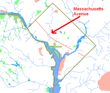
Embassy Row is the informal name for a section of Northwest Washington, D.C., with a high concentration of embassies, diplomatic missions, and diplomatic residences. It spans Massachusetts Avenue N.W. between 18th and 35th street, bounded by Scott Circle to the south and the United States Naval Observatory to the north; the term is often applied to nearby streets and neighborhoods that also host diplomatic buildings, such as Kalorama.

<span class="mw-page-title-main">Northwest (Washington, D.C.)</span> Quadrant in the United States

Northwest is the northwestern quadrant of Washington, D.C., the capital of the United States, and is located north of the National Mall and west of North Capitol Street. It is the largest of the four quadrants of the city, and it includes the central business district, the Federal Triangle, and the museums along the northern side of the National Mall, as well as many of the District's historic neighborhoods.

<span class="mw-page-title-main">14th Street (Washington, D.C.)</span> Street in northwest and southwest quadrants of Washington, D.C., US

14th Street NW/SW is a street in Northwest and Southwest quadrants of Washington, D.C., located 1.25 miles (2.01 km) west of the U.S. Capitol. It runs from the 14th Street Bridge north to Eastern Avenue.

<span class="mw-page-title-main">Constitution Avenue</span> Street in the city of Washington, D.C.

Constitution Avenue is a major east–west street in the northwest and northeast quadrants of the city of Washington, D.C., in the United States. It was originally known as B Street, and its western section was greatly lengthened and widened between 1925 and 1933. It received its current name on February 26, 1931, though it was almost named Jefferson Avenue in honor of Thomas Jefferson.

<span class="mw-page-title-main">Outdoor sculpture in Washington, D.C.</span>

There are many outdoor sculptures in Washington, D.C. In addition to the capital's most famous monuments and memorials, many figures recognized as national heroes have been posthumously awarded with his or her own statue in a park or public square. Some figures appear on several statues: Abraham Lincoln, for example, has at least three likenesses, including those at the Lincoln Memorial, in Lincoln Park, and the old Superior Court of the District of Columbia. A number of international figures, such as Mohandas Gandhi, have also been immortalized with statues. The Statue of Freedom is a 19½-foot tall allegorical statue that rests atop the United States Capitol dome.

<span class="mw-page-title-main">Connecticut Avenue</span> Thoroughfare in Washington, D.C., and Maryland

Connecticut Avenue is a major thoroughfare in the Northwest quadrant of Washington, D.C., and suburban Montgomery County, Maryland. It is one of the diagonal avenues radiating from the White House, and the segment south of Florida Avenue was one of the original streets in Pierre (Peter) Charles L'Enfant's plan for Washington. A five-mile segment north of Rock Creek was built in the 1890s by a real-estate developer.

<span class="mw-page-title-main">16th Street NW</span> Road in Washington, D.C.

16th Street Northwest, briefly known as the Avenue of the Presidents, is a prominent north-south boulevard in Washington, D.C., located in Northwest D.C. The street was laid out as part of the 1791 L'Enfant Plan, which served as the original blueprint for the city. The street begins just north of the White House, across from Lafayette Square in the President's Park, and continues north along the Washington meridian until Blair Circle.

<span class="mw-page-title-main">Florida Avenue</span>

Florida Avenue is a major street in Washington, D.C. It was originally named Boundary Street, because it formed the northern boundary of the Federal City under the 1791 L'Enfant Plan. With the growth of the city beyond its original borders, Boundary Street was renamed Florida Avenue in 1890.

<span class="mw-page-title-main">M Street (Washington, D.C.)</span> Four streets of the same name in Washington, D.C.

The name "M Street" refers to two major roads in the United States capital of Washington, D.C. Because of the Cartesian coordinate system used to name streets in Washington, the name "M Street" can be used to refer to any east-west street located twelve blocks north or south of the dome of the United States Capitol. Thus, in all four quadrants of the city there are streets called "M Street", which are disambiguated by quadrant designations, namely, M Street NW, NE, SW, and SE.

<span class="mw-page-title-main">DC Circulator</span> Bus system in Washington, D.C

The DC Circulator is a bus system in Washington, D.C. The District of Columbia Department of Transportation operates the service in a public–private partnership with RATP Dev.

<span class="mw-page-title-main">Scott Circle</span>

Scott Circle is an area in the northwest quadrant of Washington, D.C. that is centred on the junction of Massachusetts Avenue, Rhode Island Avenue, and 16th Street, N.W. Originally a neighborhood recreational area like nearby Dupont Circle, Scott has lost all social uses except as the location for public memorials.

<span class="mw-page-title-main">Thomas Circle</span> Traffic circle

Thomas Circle is a traffic circle in Northwest Washington, D.C., United States. It is located at the intersection of 14th Street, M Street, Massachusetts Avenue, and Vermont Avenue NW. A portion of Massachusetts Avenue travels through a tunnel underneath the circle. The interior of the circle includes the equestrian statue of George Henry Thomas, a Union Army general in the Civil War.

The streets and highways of Washington, D.C., form the core of the surface transportation infrastructure in Washington, D.C., the federal capital of the United States. Given that it is a planned city, the city's streets follow a distinctive layout and addressing scheme. There are 1,500 miles (2,400 km) of public roads in the city, of which 1,392 miles (2,240 km) are owned and maintained by city government.

<span class="mw-page-title-main">Sheridan Circle</span> Traffic circle in Washington D.C.

Sheridan Circle is a traffic circle and park in the Sheridan-Kalorama neighborhood of Washington, D.C. The traffic circle, one of two in the neighborhood, is the intersection of 23rd Street NW, Massachusetts Avenue NW, and R Street NW. The buildings along this stretch of Massachusetts Avenue NW are part of Embassy Row, which runs from Scott Circle to Observatory Circle. Sheridan Circle is a contributing property to the Massachusetts Avenue Historic District and the Sheridan-Kalorama Historic District, both listed on the National Register of Historic Places (NRHP). In addition, the equestrian statue of General Philip Sheridan is 1 of 18 Civil War Monuments in Washington, D.C., that were collectively listed on the NRHP.

<span class="mw-page-title-main">Stanton Park</span> Park in Washington, D.C., U.S.

Stanton Park, previously known as Stanton Square, is a national park in Washington D.C. It is located at the intersection of Maryland Avenue and Massachusetts Avenue in the Capitol Hill neighborhood of Northeast, Washington, D.C. It is bounded by 4th Street to the west and 6th Street to the east. North and south of the park are the respective westbound and eastbound lanes of C Street, NE.

<span class="mw-page-title-main">Sheridan-Kalorama Historic District</span> United States historic place

The Sheridan-Kalorama Historic District is a neighborhood and historic district located in the northwest quadrant of Washington, D.C. The boundaries of the historic district include Rock Creek Park to the north and west, P Street to the south, and 22nd Street and Florida Avenue to the east. On the southwestern edge of the neighborhood is a stretch of Embassy Row on Massachusetts Avenue. The other neighborhood and historic district that lies to the east of Sheridan-Kalorama is Kalorama Triangle Historic District. The two neighborhoods are divided by Connecticut Avenue. For many years both neighborhoods were geographically connected before the stretch of Connecticut Avenue was installed towards the Taft Bridge. Often times, both neighborhoods are simply called "Kalorama" or "Kalorama Heights".

Daniel Boone Clarke Waggaman was an architect, designer, and lawyer. He designed residences, apartments, commercial buildings, townhouses, and country estates throughout America, most notably the Washington, D.C., districts: Dupont Circle, Sheridan Kalorama, Massachusetts Ave. Heights, West End, and Connecticut Ave.

References

  1. 1 2 "National Register Information System". National Register of Historic Places . National Park Service. March 13, 2009.
  2. L'Enfant identified himself as "Peter Charles L'Enfant" during most of his life, while residing in the United States. He wrote this name on his "Plan of the city intended for the permanent seat of the government of t(he) United States ...." Archived 2016-01-11 at the Wayback Machine (Washington, D.C.) and on other legal documents. However, during the early 1900s, a French ambassador to the United States, Jean Jules Jusserand, popularized the use of L'Enfant's birth name, "Pierre Charles L'Enfant". (Reference: Bowling, Kenneth R. (2002). Peter Charles L'Enfant: Vision, Honor, and Male Friendship in the Early American Republic. George Washington University, Washington, D.C. ISBN   978-0-9727611-0-9). The United States Code states in 40 U.S.C. 3309 Archived 2021-04-02 at the Wayback Machine : "(a) In General.The purposes of this chapter shall be carried out in the District of Columbia as nearly as may be practicable in harmony with the plan of Peter Charles L'Enfant." The National Park Service identifies L'Enfant as Major Peter Charles L'Enfant Archived 2014-04-05 at the Wayback Machine and as Major Pierre (Peter) Charles L'Enfant Archived 2010-04-03 at the Wayback Machine on its website.
  3. "Approve Street Extensions Archived 2021-10-04 at the Wayback Machine ". The Washington Post. January 3, 1906. p. 11.