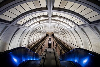
Tenleytown–AU station is a subway station on the Red Line of the Washington Metro in Washington, D.C. Located in the Upper Northwest neighborhood, it is the last station on the Red Line heading outbound wholly within the District of Columbia; the next stop, Friendship Heights, lies within both the District and the state of Maryland. The station serves American University (AU).

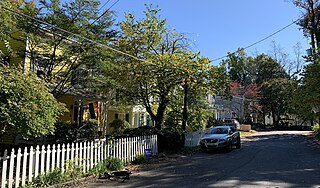
Tenleytown is a historic neighborhood in Northwest, Washington, D.C.

Friendship Heights is an urban commercial and residential neighborhood in northwest Washington, D.C., and southern Montgomery County, Maryland. Though its borders are not clearly defined, Friendship Heights consists roughly of the neighborhoods and commercial areas around Wisconsin Avenue north of Fessenden Street NW and Tenleytown to Somerset Terrace and Willard Avenue in Maryland, and from River Road in the west to Reno Road and 41st Street in the east. Within Maryland west of Wisconsin Avenue is the Village of Friendship Heights, technically a special taxation district.

American University Park is a neighborhood of Washington, D.C., named for the American University. AU Park, as it is often abbreviated, is situated against the Maryland border in the Northwest quadrant, bounded by Massachusetts, Wisconsin, Nebraska, and Western Avenues. Tenleytown and Friendship Heights lie to the east, Embassy Row to the southeast, and Spring Valley to the southwest. Politically, it is part of Ward 3 and Advisory Neighborhood Commission 3E.

Constitution Avenue is a major east–west street in the northwest and northeast quadrants of the city of Washington, D.C., in the United States. It was originally known as B Street, and its western section was greatly lengthened and widened between 1925 and 1933. It received its current name on February 26, 1931, though it was almost named Jefferson Avenue in honor of Thomas Jefferson.

16th Street Northwest, briefly known as the Avenue of the Presidents, is a prominent north-south boulevard in Washington, D.C., located in Northwest D.C. The street was laid out as part of the 1791 L'Enfant Plan, which served as the original blueprint for the city. The street begins just north of the White House, across from Lafayette Square in the President's Park, and continues north along the Washington meridian until Blair Circle.

Wisconsin Avenue is a major thoroughfare in Washington, D.C., and its Maryland suburbs. The southern terminus begins in Georgetown just north of the Potomac River, at an intersection with K Street under the elevated Whitehurst Freeway. Wisconsin Avenue ends just north of Bethesda, Maryland—though the road designated as Maryland Route 355 continues north for miles under the name of Rockville Pike.

Barney Circle is a small residential neighborhood located between the west bank of the Anacostia River and the eastern edge of Capitol Hill in southeast Washington, D.C., in the United States. The neighborhood is characterized by its sense of community, activism, walkability, and historic feel. The neighborhood's name derives from the eponymous former traffic circle Pennsylvania Avenue SE just before it crosses the John Philip Sousa Bridge over the Anacostia. The traffic circle is named for Commodore Joshua Barney, Commander of the Chesapeake Bay Flotilla in the War of 1812.

Grant Circle is a traffic circle in the Petworth neighborhood of Northwest Washington, D.C. New Hampshire and Illinois Avenues NW, Varnum Street NW, and 5th Street NW all intersect at this circle. The park within the circle and the adjoining triangles is owned and administered by the National Park Service through its Rock Creek Park unit. The circle and the buildings flanking it were listed on the National Register of Historic Places in 2015.

Streetcars and interurbans operated in the Maryland suburbs of Washington, D.C., between 1890 and 1962.

The Immaculata Seminary Historic District, commonly known as Tenley Campus, is an 8.2-acre (3.3 ha) parcel of land, located off of Tenley Circle in the Northwest Washington, D.C. neighborhood of Tenleytown. The site of Dunblane, an early to mid-nineteenth-century Federal/Greek Revival-style manor house, it was once part of a large country estate on the outskirts of the capital city, owned by a succession of prominent Georgetown residents. From 1904 to 1906, the land was acquired by the Catholic Sisters of Providence of Saint Mary-of-the-Woods, who, for decades, operated all-girls primary, secondary, and postsecondary schools there under the Immaculata name, before being forced to shutter due to financial issues. Since 1986, it has been a satellite campus of American University, which purchased the site in part because of its proximity to Tenleytown station on the Red Line of the Washington Metro. It currently houses the school's Washington College of Law.

The N. Webster Chappell House is an historic Queen Anne style home, located at 4131 Yuma Street, Northwest, Washington, D.C., west of Tenley Circle, in the Tenleytown neighborhood.

Sears, Roebuck and Company Department Store, also known as The Cityline Building, is an historic retail building, located at 4500 Wisconsin Avenue, Northwest, Washington, D.C., in the Tenleytown neighborhood.

The Hilleary T. Burrows House is an historic Queen Anne style home, located at 4520 River Road, Northwest, Washington, D.C., west of Tenley Circle, in the Tenleytown neighborhood.
The Grant Road Historic District is located in the Tenleytown neighborhood of Washington, D.C. The two-block historic district is what remains of a former settlement in rural Washington County in the District of Columbia. It includes 13 contributing buildings and the road itself, a narrow remnant of a country road that was used by soldiers in the Civil War. Following the war, the road was named after Civil War general and President Ulysses S. Grant. Grant Road developed into a residential street lined with mostly small, two-story homes for working-class people.

The Tenley-Friendship Neighborhood Library is a branch of the District of Columbia Public Library in the Tenleytown neighborhood of Washington, D.C. It is located at 4450 Wisconsin Avenue NW. A public library branch first opened in the area in 1926, and a library at the current site opened in 1960. A redesigned library branch was built at a cost of $18 million and opened in 2011. The Washington Post described the new library building, which featured a green roof and other sustainable-design features, as "one of the best things for D.C. in decades", though it experienced years of problems with a leaky roof.

The Crosstown Line, designated Routes H2 and H4, is a daily bus route operated by the Washington Metropolitan Area Transit Authority between Brookland–CUA station and Tenleytown–AU station of the Red Line of the Washington Metro. The line operates every 24 minutes between 7AM and 9PM, and 20 - 40 minutes after 9PM at a combined frequency of 12 minutes during the day and, 20 minutes during the late nights. Trips roughly take 48 minutes to complete.
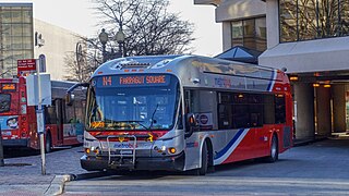
The Massachusetts Avenue Line, designated Route N2, N4, N6, is a daily bus route operated by the Washington Metropolitan Area Transit Authority between Friendship Heights station of the Red Line of the Washington Metro and Farragut Square in Downtown Washington DC. The line operates every 27 minutes during the weekdays and 40 minutes on weekends. Trips take roughly 45 minutes to complete.

Reno was a town and then neighborhood in Washington, D.C. that existed from the 1860s into the mid-twentieth century on the ground that is now Fort Reno Park in the Tenleytown neighborhood. The town's residents were largely African American, which eventually led to its clearance for Fort Reno Park and Alice Deal Middle School. Its original developers referred to it as Reno City, however this name faded from use before the 1920s.

