Freedom Plaza

Last updated

Freedom Plaza
Federal Plaza, Washington, DC.jpg
Freedom Plaza in Washington, D.C. in 2005
Location Northwest Washington, D.C., U.S.

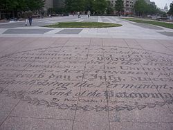
Freedom Plaza, originally known as Western Plaza, is an open plaza in Northwest Washington, D.C., United States, located near 14th Street and Pennsylvania Avenue NW, adjacent to Pershing Park. The plaza features an inlay that partially depicts Pierre (Peter) Charles L'Enfant's plan for the City of Washington. The National Park Service administers the Plaza as part of its Pennsylvania Avenue National Historic Site and coordinates the Plaza's activities. [1]

Contents

The John A. Wilson Building, the seat of the District of Columbia government, faces the plaza, as does the historic National Theatre, which has been visited by every U.S. president since it opened in 1835. [2] [3] Three large hotels are to the north and west. The Old Post Office building, which houses the Waldorf Astoria Washington D.C., is to the southeast. [4]

History

20th century

The Pennsylvania Avenue Development Corporation constructed "Western Plaza", which was dedicated on November 1, 1980 (see: History of Pennsylvania Avenue). [5] The plaza was renamed in 1988 to "Freedom Plaza" in honor of Martin Luther King Jr., who worked on his "I Have a Dream" speech in the nearby Willard Hotel. [2] [5] [6] During that year, a time capsule containing a Bible, a robe, and other King relics was planted at the site. [5] [7] The capsule will be reopened in 2088. [7]

21st century

The Plaza is one of the settings in Dan Brown's 2009 novel The Lost Symbol . [8]

In 2011, the Plaza was one of the sites of an Occupy D.C. protest. [9]

In 2014, the American Planning Association noted that Freedom Plaza is a popular location for political protests and other events. [10] However, a reporter for the Washington Business Journal stated "but that does not mean the concrete expanse across from the John A. Wilson Building was well planned". [10] Many observers consider the site a "failure." [11]

On July 17, 2020, the Plaza hosted two living statues that mocked President Donald Trump. The Trump Statue Initiative installed the live display, which a violinist accompanied, around 9:30 a.m. The display was gone by the afternoon. [12]

During the morning of November 14, 2020, thousands of President Donald Trump's supporters gathered in and around Freedom Plaza for a series of demonstrations associated with the "Million MAGA March". Various groups including Women for America First and March for Trump organized the event to protest the results of the November 3 presidential election. [13] Counter-protesters later confronted the demonstrators, leading to violence during the evening. [14]

On December 12, 2020, a pro-Trump demonstration in and near the Plaza later also resulted in nighttime counter-protests, violence, and arrests. [15]

On January 13, 2024, Freedom Plaza was used as a venue during the March on Washington for Gaza. According to protest organizers, around 400,000 protesters were in the vicinity of the plaza. [16]

Features

The Plaza is a modification of an original design by architect Robert Venturi that the United States Commission of Fine Arts approved. [2] [3] [5] [6] [17] The Plaza, which is composed mostly of stone, is inlaid with a partial depiction of L'Enfant's plan for the City of Washington. [5] Most of the plaza is raised above street level. [5] The eastern end of the plaza contains an equestrian statue of Kazimierz Pułaski that had been installed at its site in 1910. [5]

The surface of the raised portion of the Plaza, consisting of dark and light marble, delineates L’Enfant's plan. [5] Brass outlines mark the sites of the White House and the Capitol. [5] Quotes about the city from its visitors and residents are carved into the marble surface. [5] Granite retaining walls, marked at intervals by planted urns, edge the plaza. [5] A granite-walled fountain flows in the western portion of the plaza. [5]

Flagpoles flying flags of the District of Columbia and the United States rise from the plaza opposite the entrance of the District Building. [5] The Plaza also contains a metallic plaque containing the Great Seal of the United States, [18] followed by an inscription describing the history and usage of the seal. The Plaza is one block south of the "Freedom Plaza" historical marker at stop number W.7 of the Civil War to Civil Rights Downtown Heritage Trail at 13th and E Streets, NW. [2] [3]

The Plaza is a popular location for skateboarding, although the illegal sport damages stonework, walls, steps, and sculpture while presenting a persistent law enforcement and management challenge. Popular websites advertise Freedom Plaza's attractiveness for the activity. [19] Further, vandals have removed "No Skateboarding" signs. [19]

Related Research Articles

<span class="mw-page-title-main">Pennsylvania Avenue</span> Street in Maryland and Washington, D.C., US

Pennsylvania Avenue is a primarily diagonal street in Washington, D.C. that connects the United States Capitol with the White House and then crosses northwest Washington, D.C. to Georgetown. Traveling through southeast Washington from the Capitol, it enters Prince George's County, Maryland, and becomes MD Route 4 and then MD Route 717 in Upper Marlboro, and finally Stephanie Roper Highway.

<span class="mw-page-title-main">National Mall</span> Landscaped park in Washington, D.C.

The National Mall is a landscaped park near the downtown area of Washington, D.C., the capital city of the United States. It contains and borders a number of museums of the Smithsonian Institution, art galleries, cultural institutions, and various memorials, sculptures, and statues. It is administered by the National Park Service (NPS) of the United States Department of the Interior as part of the National Mall and Memorial Parks unit of the National Park System. The park receives approximately 24 million visitors each year. Designed by Pierre L'Enfant, the "Grand Avenue" or Mall was to be a democratic and egalitarian space—the complete opposite of the gardens of Versailles where only royalty and nobility accessed similar spaces in size and scope. It was to be flanked by gardens and spacious accommodations for foreign ministers.

<span class="mw-page-title-main">Pierre Charles L'Enfant</span> French-American architect (1754–1825)

Pierre "Peter" Charles L'Enfant was a French-American artist, professor, and military engineer who in 1791 designed the baroque styled plan for Washington, D.C., the capital city of the United States. His work is known today as the L'Enfant Plan which inspired plans for other world capitals such as Brasilia, New Delhi, and Canberra. In the United States, plans for Detroit and Indianapolis took inspiration from the plan for Washington, DC.

<span class="mw-page-title-main">L'Enfant Plaza</span> Building complex in Washington, D.C.

L'Enfant Plaza is a complex of four commercial buildings grouped around a large plaza in the Southwest section of Washington, D.C., United States. Immediately below the plaza and the buildings is La Promenade shopping mall.

The Washington meridians are four meridians that were used as prime meridians in the United States which pass through Washington, D.C. The four that have been specified are:

  1. through the Capitol
  2. through the White House
  3. through the old Naval Observatory
  4. through the new Naval Observatory.
<span class="mw-page-title-main">Massachusetts Avenue (Washington, D.C.)</span> Major road in Washington, D.C., U.S.

Massachusetts Avenue is a major diagonal transverse road in Washington, D.C., and the Massachusetts Avenue Historic District is a historic district that includes part of it.

<span class="mw-page-title-main">16th Street NW</span> Road in Washington, D.C.

16th Street Northwest, briefly known as the Avenue of the Presidents, is a prominent north-south boulevard in Washington, D.C., located in Northwest D.C. The street was laid out as part of the 1791 L'Enfant Plan, which served as the original blueprint for the city. The street begins just north of the White House, across from Lafayette Square in the President's Park, and continues north along the Washington meridian until Blair Circle.

<span class="mw-page-title-main">Pennsylvania Avenue National Historic Site</span> National Historic Site of the United States in Washington, D.C.

Pennsylvania Avenue National Historic Site is a National Historic Site in the city of Washington, D.C. Established on September 30, 1965, the site is roughly bounded by Constitution Avenue, 15th Street NW, F Street NW, and 3rd Street NW. The historic district includes a number of culturally, aesthetically, and historically significant structures and places, including Pennsylvania Avenue NW from the White House to the United States Capitol, the Treasury Building, Freedom Plaza, Federal Triangle, Ford's Theatre, the Old Patent Office Building, the Old Pension Office Building, which now houses the National Building Museum, Judiciary Square, and the Peace Monument.

National Mall and Memorial Parks is an administrative unit of the National Park Service (NPS) encompassing many national memorials and other areas in Washington, D.C. Federally owned and administered parks in the capital area date back to 1790, some of the oldest in the United States. In 1933, they were transferred to the control of the National Park Service. These parks were known as the National Capital Parks from their inception until 1965. The NPS now operates multiple park groupings in the D.C. area, including National Capital Parks-East, Rock Creek Park, President's Park, and George Washington Memorial Parkway. National Mall and Memorial Parks also provides technical assistance for the United States Navy Memorial.

<span class="mw-page-title-main">Jefferson Pier</span>

Jefferson Pier, Jefferson Stone, or the Jefferson Pier Stone, in Washington, D.C., marks the second prime meridian of the United States even though it was never officially recognized, either by presidential proclamation or by a resolution or act of Congress.

<span class="mw-page-title-main">Sheridan Circle</span> Traffic circle in Washington D.C.

Sheridan Circle is a traffic circle and park in the Sheridan-Kalorama neighborhood of Washington, D.C. The traffic circle, one of two in the neighborhood, is the intersection of 23rd Street NW, Massachusetts Avenue NW, and R Street NW. The buildings along this stretch of Massachusetts Avenue NW are part of Embassy Row, which runs from Scott Circle to Observatory Circle. Sheridan Circle is a contributing property to the Massachusetts Avenue Historic District and the Sheridan-Kalorama Historic District, both listed on the National Register of Historic Places (NRHP). In addition, the equestrian statue of General Philip Sheridan is 1 of 18 Civil War Monuments in Washington, D.C., that were collectively listed on the NRHP.

<span class="mw-page-title-main">Downtown (Washington, D.C.)</span> United States historic place

Downtown is the central business district of Washington, D.C., located in Northwest D.C. It is the third largest central business district in the United States. The "Traditional Downtown" has been defined as an area roughly between Union Station in the east and 16th Street NW in the west, and between the National Mall on the south and Massachusetts Avenue on the north, including Penn Quarter. However, nowadays, Downtown D.C. usually refers to a larger area, as the DC Office of Planning states:

…most residents, workers, and visitors think of Downtown in a broader sense — including areas as far north as Dupont Circle, as far west as Foggy Bottom, and as far east as Capitol Hill. Only about half of the central city workforce is located within the city’s traditional Downtown.

<span class="mw-page-title-main">Equestrian statue of George Washington (Washington Circle)</span> Statue by Clark Mills in Washington, D.C., U.S.

Lieutenant General George Washington is an 1860 equestrian statue of George Washington, at Washington Circle, at the edge of the George Washington University's campus, in Washington, D.C. The statue was sculpted by Clark Mills, who also created the equestrian statue of Andrew Jackson in front of the White House. The traffic circle where the statue is located was one of the original city designs by Pierre Charles L'Enfant. The statue and surrounding park are in the Foggy Bottom neighborhood at the intersection of 23rd Street, New Hampshire Avenue, and Pennsylvania Avenue NW. The K Street NW underpass runs beneath the circle.

<span class="mw-page-title-main">Statue of John Witherspoon</span> Statue by William Couper in Washington, D.C., U.S.

Doctor John Witherspoon is a bronze sculpture and granite pedestal which depicts John Witherspoon, a Presbyterian minister, member of Congress, and signer of the Declaration of Independence. Born in Scotland, Witherspoon immigrated to the U.S. in the 1760s and later became president of the College of New Jersey. He strongly supported the Thirteen Colonies in their fight to obtain freedom from the United Kingdom of Great Britain and Ireland.

<span class="mw-page-title-main">Statue of Benjamin Franklin (Washington, D.C.)</span>

The outdoor statue of Benjamin Franklin in Washington, D.C., is located near the intersection of 12th Street and Pennsylvania Avenue, in front of the Old Post Office. The statue was a gift from Stilson Hutchins, founder of The Washington Post, who wanted to display his and the newspaper's stature in the city. The designer, Ernst Plassmann, and sculptor, Jacques Jouvenal, were both German-American artists. The architect of the memorial was J. F. Manning.

<span class="mw-page-title-main">Equestrian statue of Casimir Pulaski</span> Statue by Kazimierz Chodziński in Washington, D.C., U.S.

General Casimir Pulaski is a bronze equestrian statue of Casimir Pulaski, a military man born in the Polish–Lithuanian Commonwealth. He joined the military at a young age, fighting for removal of the king, who was backed by Russia. After his side lost the war, he fled to Paris, where he met Benjamin Franklin. Impressed by Pulaski, Franklin wrote a letter of recommendation to George Washington, suggesting he would be a helpful soldier during the American Revolutionary War. After arriving in the U.S., Pulaski eventually was promoted to Brigadier General and commanded a cavalry unit, the Pulaski's Legion. He died in 1779 due to injuries sustained in battle.

<span class="mw-page-title-main">American Revolution Statuary</span> Statuary in Washington D.C., United States

American Revolution Statuary is a group of fourteen statues in Washington, D.C., which honor men whose actions assisted the Thirteen Colonies in their fight against the Kingdom of Great Britain in the American Revolutionary War. They are spread throughout the city, except for the four statues in Lafayette Square, across from the White House, that honor some of the foreign heroes from the war. Some of the statues are located in prominent places, while others are in small parks or stand alone in front of buildings. All of the statues are owned and maintained by the National Park Service, an agency of the United States Department of the Interior. The statuary was collectively listed on the National Register of Historic Places (NRHP) in 1978 and the District of Columbia Inventory of Historic Sites the following year. In addition, most are also contributing properties to historic districts listed on the NRHP.

<span class="mw-page-title-main">L'Enfant Plan</span> United States historic place; street and land use plan for Washington, DC

The L'Enfant Plan for the city of Washington is the urban plan developed in 1791 by Major Pierre (Peter) Charles L'Enfant for George Washington, the first president of the United States. It is regarded as one of the most amazing urban design plans in the world and has inspired plans for other world capitals such as Brasilia, New Delhi, and Canberra. In the United States, plans for Detroit and Indianapolis took inspiration from the plan for Washington, DC.

<span class="mw-page-title-main">Garden Club of America Entrance Markers in Washington, D.C.</span> United States historic place

The Garden Club of America Entrance Markers in Washington, D.C., are carven stone pylons installed along the border of the District of Columbia in 1932 and 1933 by local Garden Club of America chapters. Originally about five feet tall, the markers were placed at important entrance points to the national capital. Seven survive: sets of two markers in Westmoreland Circle, Friendship Heights, and Chevy Chase Circle; and a single marker along Georgia Avenue. These surviving markers are listed on the National Register of Historic Places.

<span class="mw-page-title-main">Rawlins Park</span> Park in Washington, D.C., U.S.

Rawlins Park is a rectangular public park in the Foggy Bottom neighborhood of Washington, D.C., two blocks west of the White House grounds and two blocks north of the National Mall. The boundaries of the park are 18th Street NW to the east, E Street NW to the south and north, and 19th Street NW to the west. The park was an undeveloped open space for many years, until plans were made to install the statue of John Aaron Rawlins in 1874. Various improvements were made, but the area surrounding the park remained mostly undeveloped. This changed in the 1890s when the area was cleared of marshes, and houses were built on the park's southern border.

References

  1. "What does this park contain?". Frequently Asked Questions: Pennsylvania Avenue National Historic Site: District of Columbia. National Park Service: United States Department of the Interior. Archived from the original on February 6, 2017. Retrieved March 27, 2017..
  2. 1 2 3 4 Miller, Richard E. (April 14, 2009). "Freedom Plaza: Civil War to Civil Rights: Downtown Heritage Trail marker". Historical Marker Database. Archived from the original on October 18, 2020. Retrieved October 28, 2011..
  3. 1 2 3 Busch, Richard T.; Smith, Kathryn Schneider. "W.7: Freedom Plaza: 13th and E Sts NW". Civil War to Civil Rights Downtown Heritage Trail. Washington, D.C.: Cultural Tourism DC. Archived from the original on March 21, 2016. Retrieved March 27, 2017..
  4. Coordinates of Old Post Office building: 38°53′39″N77°1′39″W / 38.89417°N 77.02750°W
  5. 1 2 3 4 5 6 7 8 9 10 11 12 13 Robinson, Judith H.; Cantrell, Sophie; Kerr, Tim (Robinson and Associates, Washington, D.C.) (August 23, 2004). "Pennsylvania Avenue National Historic Site" (PDF). United States Department of the Interior: National Park Service: National Register of Historic Places Registration Form: Continuation Sheet: Section 7. Washington, D.C.: United States Department of the Interior: National Park Service. p. 8. Archived (PDF) from the original on September 28, 2020. Retrieved March 5, 2021.{{cite web}}: CS1 maint: multiple names: authors list (link).
  6. 1 2 Cooper, Rachel (2017). "Freedom Plaza in Washington, DC". About.com: About Travel: Washington, DC: Sports & Recreation: Parks and Recreation: DC Parks. About, Inc. Archived from the original on January 26, 2017. Retrieved March 27, 2017.
  7. 1 2 Contrera, Jessica (October 3, 2014). "Under Freedom Plaza (Pennsylvania Avenue between 13 and 14th Streets NW)". There are time capsules buried all over D.C. The Washington Post. Archived from the original on March 29, 2017. In 1988, Western Plaza became Freedom Plaza in memory of Martin Luther King, Jr.'s 1963 "I Have A Dream" speech. Fittingly, a time capsule in his memory was buried underneath it. When it is opened in 2088, historians will find King's bible, a robe he wore to preach in and audio recordings of some of his speeches.
  8. (1) Ray, Rachel (September 29, 2009). "Dan Brown's The Lost Symbol and Washington DC". The Daily Telegraph . Archived from the original on October 1, 2009. Retrieved March 29, 2017.
    (2) "The Lost Symbol". washington.org. Archived from the original on September 13, 2009. Retrieved March 29, 2017.
  9. Gowen, Annie (October 6, 2011). "'Occupy DC' protesters rally in Freedom Plaza". The Washington Post . Archived from the original on March 29, 2017. Retrieved March 29, 2017.
  10. 1 2 Neibauer, Michael (October 1, 2014). "Pennsylvania Avenue Is A 'Great Street' Indeed, and In Need". Washington Business Journal. p. 2. Archived from the original on October 7, 2014. Retrieved March 29, 2017. Yes, Freedom Plaza "remains a popular location for political protests and other events," as the association describes it, but that does not mean the concrete expanse across from the John A. Wilson Building was well planned.
  11. Goldchain, Michelle (July 31, 2018). "Why is Pennsylvania Avenue's Freedom Plaza such a failure?". Greater Greater Washington. Archived from the original on August 16, 2018. Retrieved October 30, 2018. One group of people do use Freedom Plaza regularly: skateboarders. The open hardscape and railings of Freedom Plaza make an excellent and popular skate park, though skating there is not actually allowed and Park Police regularly chase skaters from the park.
    Scott Brown said, "They came from all over the country to wreck our plaza, which they nearly did, and all those inscriptions on the floor and everything else, that's ruined by roller skating."
  12. (1) Beaujon, Andrew (July 17, 2020). "Living Statues That Mocked Trump Appeared Near the White House Today". Washingtonian. Archived from the original on July 18, 2020. Retrieved September 25, 2020.
    (2) Diaz, Ann-Christine (July 20, 2020). "'King of the Super Bowl' Bryan Buckley trolls Trump with living statues in D.C." Creativity. Ad Age . Retrieved September 9, 2020.
  13. Pusatory, Matt (November 14, 2020). "President Trump visits supporters at Freedom Plaza ahead of Million MAGA March". WUSA9 . Archived from the original on November 15, 2020. Retrieved November 16, 2020.
  14. (1) Merchant, Zach; Pusatory, Matt; Valerio, Mike (November 15, 2020). "Counter-protesters, pro-Trump supporters gather in DC after Million MAGA March earlier on Saturday". WUSA9 . Archived from the original on November 16, 2020. Retrieved November 16, 2020..
    (2) Lang, Marissa J.; Miller, Michael E.; Jamison, Peter; Moyer, Justin Wm; Williams, Clarence; Hermann, Peter; Kunkle, Fredrick; Cox, John Woodrow (November 15, 2020). "After thousands of Trump supporters rally in D.C., violence erupts when night falls". The Washington Post . ISSN   0190-8286. Archived from the original on March 15, 2021. Retrieved March 15, 2021.
  15. Davies, Emily; Weiner, Rachel; Williams, Clarence; Lang, Marissa J.; Contrera, Jessica (December 12, 2020). "Multiple people stabbed after thousands gather for pro-Trump demonstrations in Washington". The Washington Post . ISSN   0190-8286. Archived from the original on December 12, 2020. Retrieved December 13, 2020.
  16. Allison, Ismail (January 13, 2024). "CAIR Commends 400,000+ Marchers for Historic Turnout at March on Washington for Gaza".
  17. Miller, Richard E. (April 13, 2009). "Western Plaza, Pennsylvania Avenue (Freedom Plaza) Marker". Historical Marker Database. Archived from the original on October 19, 2011. Retrieved March 21, 2011.
  18. "Photo: Great Seal of the United States found in Freedom Plaza [front]". The Keys to The Lost Symbol: Photo Gallery. WikiFoundry. Retrieved March 29, 2017.
  19. 1 2 "Skateboarding" (PDF). Pennsylvania Avenue National Historic Site Management Plan: Visitor Information, Education and Enjoyment. Washington, D.C.: National Mall and Memorial Parks: National Park Service: United States Department of the Interior. April 2014. pp. 24–25. Archived (PDF) from the original on March 4, 2017. Retrieved March 29, 2017. Skateboarding damages stonework, walls, steps, and sculpture in some areas and presents a persistent law enforcement and management challenge. Damaged areas include stone facing on memorials, benches, and other surfaces. Moreover, popular websites advertise the attractiveness of these areas for skateboarding, which indicates the large scope of this challenge. .... Actions: .... In park areas replace and maintain "No Skateboarding" signs that have been vandalized.

38°53′45″N77°1′50.6″W / 38.89583°N 77.030722°W / 38.89583; -77.030722