Chevy Chase is the name of both a town and an unincorporated census-designated place that straddle the northwest border of Washington, D.C. and Montgomery County, Maryland, United States. Several settlements in the same area of Montgomery County and one neighborhood of Washington include Chevy Chase in their names. These villages, the town, and the CDP share a common history and together form a larger community colloquially referred to as Chevy Chase.

Fort Totten is a Washington Metro station in northeastern Washington, D.C. It acts as a transfer point between the Green, Yellow and Red Lines. It is the last station on the Green and Yellow lines in the District of Columbia before heading into Maryland. It is triply unique in being a 3-story station, being the only multi-level transfer station built above ground, and being the only such station to have island platforms on both levels, as opposed to just the lower level. The station's name comes from a Civil War-era fortification which itself was named after General Joseph Gilbert Totten, the Chief Engineer of the antebellum US Army.

Southeast is the southeastern quadrant of Washington, D.C., the capital of the United States, and is located south of East Capitol Street and east of South Capitol Street. It includes the Capitol Hill and Anacostia neighborhoods, the Navy Yard, the Joint Base Anacostia-Bolling (JBAB), the U.S. Marine Barracks, the Anacostia River waterfront, Eastern Market, the remains of several Civil War-era forts, historic St. Elizabeths Hospital, RFK Stadium, Nationals Park, and the Congressional Cemetery. It also contains a landmark known as "The Big Chair," located on Martin Luther King Jr. Avenue. The quadrant is split by the Anacostia River, with the portion that is west of the river sometimes referred to as "Near Southeast". Geographically, it is the second-smallest quadrant of the city.
Northwest is the northwestern quadrant of Washington, D.C., the capital of the United States, and is located north of the National Mall and west of North Capitol Street. It is the largest of the four quadrants of the city, and it includes the central business district, the Federal Triangle, and the museums along the northern side of the National Mall, as well as many of the District's historic neighborhoods.
Northeast is the northeastern quadrant of Washington, D.C., the capital of the United States. It encompasses the area located north of East Capitol Street and east of North Capitol Street.

Friendship Heights is an urban commercial and residential neighborhood in northwest Washington, D.C. and southern Montgomery County, Maryland. Though its borders are not clearly defined, Friendship Heights consists roughly of the neighborhoods and commercial areas around Wisconsin Avenue north of Fessenden Street NW and Tenleytown to Somerset Terrace and Willard Avenue in Maryland, and from River Road in the west to Reno Road and 41st Street in the east. Within Maryland west of Wisconsin Avenue is the Village of Friendship Heights, technically a special taxation district.

Advisory Neighborhood Commissions are bodies of local government in District of Columbia, in the United States. The ANC system was created in 1974 through a District referendum in the District of Columbia Home Rule Act. The first elections for Advisory Neighborhood Commissioners were held in the fall of 1975, and commissions began operating in 1976. Congressman Don Fraser (D-Minn) and DC resident Milton Kotler helped to draft the ANC language in the District of Columbia Home Rule Act based on the success of Adams Morgan Organization (AMO) in Adams Morgan and on a 1970 report of the Minneapolis Citizen League, as well as on related neighborhood corporations in Pittsburgh, Brooklyn, Chicago and Columbus, Ohio.
Chevy Chase is a neighborhood in northwest Washington, D.C. It borders Chevy Chase, Maryland, a collection of similarly affluent neighborhoods.

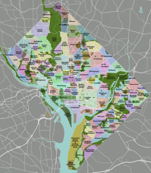
Neighborhoods in Washington, D.C., are distinguished by their history, culture, architecture, demographics, and geography. The names of 131 neighborhoods are unofficially defined by the D.C. Office of Planning. Neighborhoods can be defined by the boundaries of wards, historic districts, Advisory Neighborhood Commissions, civic associations, and business improvement districts (BIDs); these boundaries will overlap. The eight wards each elect a member to the Council of the District of Columbia and are redistricted every ten years.

Connecticut Avenue is a major thoroughfare in the Northwest quadrant of Washington, D.C., and suburban Montgomery County, Maryland. It is one of the diagonal avenues radiating from the White House, and the segment south of Florida Avenue was one of the original streets in Pierre (Peter) Charles L'Enfant's plan for Washington.

Francis Griffith Newlands was a United States Representative and Senator from Nevada and a member of the Democratic Party.

Fort Totten is a neighborhood located in Ward 5 of Northeast Washington, D.C.

Queens Chapel is a mostly residential neighborhood with commercial elements located in Ward 5 of Northeast Washington, D.C.

Michigan Park is a neighborhood in Ward 5 of Northeast Washington, D.C. in the Upper Northeast area element. The boundaries of Michigan Park and North Michigan Park neighborhoods are contested due to the history of racial disparity between the two, but in general Michigan Park is considered to be contained between South Dakota Avenue to the west, Eastern Avenue to the east, Galloway Street NE to the north and Taylor Street NE to the South. Both neighborhoods are in DC Neighborhood Cluster 20 along with the University Heights neighborhood. Michigan Park is home to two established Civic Associations: the North Michigan Park Civic Association which has its established boundaries that include both Michigan Park and North Michigan Park and the Queens Chapel Civic Association. The Queens Chapel association meets regularly at Union Wesley African Methodist Zion Church and its boundaries are between 16th Street NE and Webster Street NE to the north, Michigan Avenue NE to the south, and South Dakota Avenue NE to the west.
North Michigan Park is a neighborhood located in Ward 5 of Northeast Washington, D.C. North Michigan Park is contained between Eastern Avenue N.E. to the east, Gallatin Street N.E. to the north, Michigan Avenue N.E. to the south, and South Dakota Avenue N.E. to the west. North Michigan Park borders the neighborhoods of Michigan Park, Queens Chapel, and Woodridge, which also are located in Ward 5 of Northeast Washington D.C. In addition to these neighborhoods in Ward 5 of Northeast Washington D.C., North Michigan Park also borders the adjacent neighborhoods of Avondale and Chillum, which are both located in Prince George's County, Maryland. North Michigan Park neighborhood is often confused with the North Michigan Park Civic Association which has boundaries that include both North Michigan Park and Michigan Park. North Michigan Park and Michigan Park neighborhoods have been historically designated as separate neighborhoods due to the fact that they were segregated by race. North Michigan Park was the less desirable neighborhood where African-Americans lived while Michigan Park was a much more desirable neighborhood where the neighborhood where their white counterparts lived. Both neighborhoods are separated from each other by South Dakota Avenue N.E. The Washington Metropolitan Area Green Line train tracks pass through the North Michigan Park neighborhood, notably, through a tunnel when traveling between the West Hyattsville and Fort Totten Metro Stations. The Washington Metropolitan Area Green Line train tracks initially are above ground when traveling between the West Hyattsville Metro Station and a certain portion of the neighborhood of Avondale. The Washington Metropolitan Area Green Line tracks then gradually enter a tunnel, which they use throughout the rest of the Avondale neighborhood, a small portion of the Chillum neighborhood, the North Michigan Park neighborhood, and Queens Chapel neighborhood before entering the lower level portion of the Fort Totten Metro Station, located below the Washington Metropolitan Area Red Line train tracks.

Pleasant Hill is a neighborhood located in Ward 5 of Northeast Washington, D.C. Pleasant Hill is contained between Allison Street NE and Bates Road NE to the north, Taylor Street NE to the south, the Washington Metropolitan Area Red Line tracks to the east, and North Capitol Street NW to the west. Pleasant Hill borders the adjacent neighborhoods of Fort Totten (north), North Michigan Park (northeast), Michigan Park (east), University Heights (south), Petworth (west), Brightwood Park (northwest), and Park View (southwest). It is adjacent to the Catholic University of America and even houses its athletic facilities. Pleasant Hill houses the Catholic University of America's soccer and football fields as well as its Raymond A. DuFour Athletic Center.
The following outline is provided as an overview of and topical guide to District of Columbia:

Western Avenue is one of three boundary streets between Washington, D.C., and the state of Maryland. It follows a southwest-to-northeast line, beginning at Westmoreland Circle in the south and ending at Oregon Avenue NW in the north. It is roughly 3.5 miles (5.6 km) in length. First proposed in 1893, it was constructed somewhat fitfully from about 1900 to 1931.
Woodmont is a neighborhood in northwest Washington, D.C.

The Military Road–Crosstown Line, designated Route E4, is a daily bus route operated by the Washington Metropolitan Area Transit Authority between the Friendship Heights station of the Red Line of the Washington Metro and Fort Totten station of the Red, Green and Yellow Lines of the Washington Metro or Riggs Park. The line runs every 20 minutes between 7AM and 9PM and 30 minutes after 9PM with every other trip alternating between Friendship Heights and Fort Totten/Riggs Park. Trips take roughly 40 minutes. Additional daily trips are shortened to Fort Totten station which takes roughly 30 minutes.