Columbia Heights (Washington, D.C.)

Last updated

Columbia Heights
Tivoli Theatre (cropped).jpeg
Riggs-Tompkins Building.jpg
National Baptist Memorial Church (52109635232) (cropped).jpg
Fountain at Meridian Hill Park (cropped3).jpg
All Souls Church, 16th St. near intersection with Harvard St., NW, Washington, D.C LCCN2010641441 (cropped).tif
Columbia Hts station panorama (2864052922).jpg
Top: Tivoli Theatre (left) and Riggs-Tompkins Building (right); middle: National Baptist Memorial Church (left), Meridian Hill Park (center), and All Souls Church (right); bottom: DC USA.
DC Neighborhoods - Columbia Heights.svg
Columbia Heights within the District of Columbia
Country United States
District Washington, D.C.
Quadrant Northwest
WardWard 1
Government
  Councilmember Brianne Nadeau
Area
  Total.85 sq mi (2.2 km2)
Population
 (2010)
  Total31,696
  Density37,289.4/sq mi (14,397.5/km2)

Columbia Heights is a neighborhood in Washington, D.C., located in Northwest D.C. The neighborhood is an important retail hub for the area, as home to DC USA mall and to numerous other restaurants and stores, primarily along the highly commercialized 14th Street. [1] [2] Columbia Heights is home to numerous historical landmarks, including Meridian Hill Park, National Baptist Memorial Church, All Souls Church, along with a number of embassy buildings.

Contents

Developed as a suburb after the U.S. Civil War, the area's growth accelerated in the early 1900s. The extension of the DC streetcar system in 1914 made the neighborhood a popular place to live among federal workers. In the 1940s, the designation of Cardozo High School as a "colored" school resulted in a demographic shift and the neighborhood became predominantly African-American. The 1968 Washington, D.C., riots devastated the area and turmoil in the 1970-80s followed. [3] Beginning in the late 1990s, the addition of the Columbia Heights metro station led to the redevelopment of the neighborhood. Today the neighborhood has diverse demographics. [4] [5]

History

19th century

Columbia Heights takes its name from Columbian College (now George Washington University), which was founded in the area in 1821. Columbian College Building (engraving) - The George Washington University.tif
Columbia Heights takes its name from Columbian College (now George Washington University), which was founded in the area in 1821.

Once farmland on the estate of the Holmead family (called "Pleasant Plains"), Columbia Heights was part of Washington County, in the District of Columbia; it was within the District but outside the borders of the city of Washington. In 1815, William J. Stone, purchased a 121-acre tract of the Holmead estate—east of present-day Georgia Avenue, and north of modern Florida Ave—and established his estate known as the Stone Farm. Nearby, construction of the first building for Columbian College, now George Washington University, was completed in 1822 on the campus which was bounded by Columbia Road, 14th Street, Boundary Street (Florida Avenue) and 13th Street. The area began developing as a suburb of Washington soon after the American Civil War, when horse-drawn streetcars delivered residents of the neighborhood to downtown.

The northern portion of modern-day Columbia Heights (i.e., north of where Harvard Street currently lies) was, until the 1880s, a part of the village of Mount Pleasant. The southern portion still retained the name of the original Pleasant Plains estate, though it was also known as "Cowtown."

1903 Baist Atlas of the Columbia Heights development. Baist Atlas of Columbia Heights 1903.jpg
1903 Baist Atlas of the Columbia Heights development.

In 1871, Congress passed the D.C. Organic Act, which eliminated Washington County by extending the boundaries of Washington City to be contiguous with those of the District of Columbia. Shortly afterward, in 1881–82, Senator John Sherman, author of the Sherman Antitrust Act of 1890, purchased the land north of Boundary Street between 16th Street and 10th Street, including the Stone farm, developing it as a subdivision of the city and calling it Columbia Heights in honor of the college at its heart. (The neighborhood's eastern, major traffic artery, Sherman Avenue, is named after its early developer.) Much of Sherman's purchase was land belonging to Columbian College.

The college moved to the center of Washington's downtown business district and in 1904, changed its name to The George Washington University, in an agreement with the George Washington Memorial Association. By 1912 Columbian, now George Washington, relocated its major operations to Foggy Bottom. The federal government purchased some of the college's former land and built Meridian Hill Park in the early 20th century.

20th century

The Arcade Market, built in 1910. Arcade Market, (Washington, D.C.) LCCN2016825040 (cropped).jpg
The Arcade Market, built in 1910.

Upscale development in Columbia Heights circa 1900 was designed to attract upper level managers of the Federal government, U.S. Supreme Court justices, and high-ranking military officers. An imposing mansion known as "Belmont" marked the entrance to the neighborhood between Florida and Clifton Streets. The mansion was emblematic of the confidence that the affluent placed in the concept that Columbia Heights represented the ideal suburb. In the early 1900s, many of Washington's wealthiest residents lived in the neighborhood. Residents included authors Jean Toomer, [7] Ambrose Bierce, [8] Sinclair Lewis, Chief Justice Melville Fuller, and Justice John Marshall Harlan.

In 1901, the Commissioners of the District of Columbia renamed streets all over the District in accordance with a newly adopted street-naming system. [9] In Columbia Heights, Clifton Street, Roanoke Street, Yale Street, Princeton Street, Harvard Street, Columbia Road, Kenesaw Avenue, Kenyon Street, Dartmouth Street, and Whitney Avenue were renamed Adams Street, Bryant Street, Channing Street, Douglas Street, Evarts Street, Franklin Street, Girard Street, Hamlin Street, Hooker Street, and Irving Street, respectively. [9]

A 1910 advertisement for a housing development on Clifton Street.

In 1902, there was a building boom in North Columbia Heights, with the expansion of the streetcar down 11th St, 14th St and 16th St. Homes were being built for between $2,000 and $5,000 and a total of five million dollars' worth of homes were being built. [10]

In 1904, the Columbia Heights Citizen's Association published an illustrated brochure entitled "A Statement of Some of the Advantages of Beautiful Columbia Heights." 1904 was also the year that Congress authorized changing the names of streets to align with the alphabetical and orderly naming convention of the Old City (i.e., below Boundary Street, now Florida Avenue). [11]

By 1914, four street car lines served the section providing transportation to downtown Washington in twenty minutes. The neighborhood also became the home of the Washington Palace Five professional basketball team.

The popularity of the neighborhood resulted in the construction of several large apartment buildings during the beginning of the twentieth century that changed the suburban character of the area into a more urban and densely populated district. As of mid-century, however, Columbia Heights retained much of its upscale residential appeal, supporting establishments such as the ornate Tivoli Theatre movie house (completed in 1924).

Shrine of the Sacred Heart, built by Murphy & Olmsted in 1922 Sacred Heart DC 03.JPG
Shrine of the Sacred Heart, built by Murphy & Olmsted in 1922

J. Willard Marriott and his wife opened an A&W Root Beer franchise on 14th street in 1927, before creating the Marriott hotel chain. [12] The neighborhood was adjacent to Washington's thriving middle-class black community and came to be home to some of its most notable citizens by the 1930s.

In 1949, during the era of racial segregation in the public schools, Central High School, a white high school that bordered the southern edge of Columbia Heights, did not have enough students. It was renamed as Cardozo High School and designated as a "colored" high school to accommodate the growing African-American population in the neighborhood. Significant demographic changes began in the late 1940s when African-American residents began to buy apartment buildings previously owned by whites, and in the 1950s blacks bought individual homes in ever increasing numbers. The neighborhood was a strong middle-class African-American enclave in Washington, along with the nearby Shaw neighborhood and Howard University, through the mid-1960s.

Cardozo Education Campus Cardozo2014 (cropped).jpg
Cardozo Education Campus

The neighborhood was featured in various clips, and as the home of protagonists Helen and Bobby Benson, in the 1951 film The Day the Earth Stood Still .

In 1968, following the assassination of Martin Luther King Jr., the 1968 Washington, D.C., riots ravaged the 14th St. Corridor in Columbia Heights, along with the commercial U Street corridor nearby, and many other Washington neighborhoods to the east. Many middle-class residents moved out to the suburbs, resulting in a drop in business. As a result, many homes and shops remained vacant for decades. In addition to African Americans, the neighborhood had an increasing number of Latino immigrants and their descendants as residents.

21st century

DC USA, a mall that opened in 2008. DCUSANighttime.Wikipedia (cropped).jpg
DC USA, a mall that opened in 2008.

In 1999, the city announced a revitalization initiative for the neighborhood focused around the Columbia Heights Metro station, which opened in September of that year. The opening of the Metro station served as a catalyst for the return of economic development and residents. [13]

Nearby, Giant Food supermarket opened, and Tivoli Square, a commercial and entertainment complex, dating from the 1920s was renovated. [14]

There had already been positive developments along lower 14th Street and the U Street corridor. [15]

On March 5, 2008, DC USA, a 546,000-square-foot (50,700 m2) shopping mall across the street from the Columbia Heights Metro station opened. It includes many stores and restaurants as well as 1,000 spaces of underground parking. [16]

As of 2018, approximately 22% of the housing stock in the neighborhood was reserved for low income renters. [17]

Geography

In the Northwest quadrant of Washington, D.C., Columbia Heights borders the neighborhoods of U Street Corridor (Cardozo/Shaw), Adams Morgan, Mount Pleasant, Park View, Pleasant Plains, and Petworth. On the eastern side is Howard University. The streets defining the neighborhood's boundaries are 16th Street to the west, Spring Road to the north; Sherman Ave to the east, and Florida Avenue to the south. It is served by the Columbia Heights station on the Green line of the Washington Metro.

Demographics

Trinity AME Zion Church Trinity AME Zion DC (cropped).JPG
Trinity AME Zion Church

The 2010 census figures estimated Columbia Heights had a 43.5% African-American population, including government and other professional class; 28.1% Hispanic population; 22.9% White population; 3.2% Asian population; and a 2% Other population.

The 2000 census figures estimated Columbia Heights had a 58% African-American population, including some African immigrants of the 20th century and later, and government and professional class; 34% Hispanic population; 5.4% white population; and 3.1% other. [18]

In 2012, Columbia Heights was named one of the fastest gentrifying neighborhoods in the United States. [19]

Landmarks

Columbia Heights Civic Plaza Columbia Heights market plaza (5081654910).jpg
Columbia Heights Civic Plaza

The Columbia Heights Farmers Market, across the street from DC USA, provides neighborhood shoppers with locally produced food. [20]

In January 2005, the GALA Hispanic Theatre moved into the newly refurbished Tivoli Theatre as its first permanent home. This former movie theater, built in 1924, had been vacant since 1976. GALA is a theater company dedicated since the 1970s to performing Spanish-language plays.

In November 2006, the Dance Institute of Washington, a minority-led professional ballet and dance center, opened a 12,000-square-foot (1,100 m2) facility across the street from the Tivoli Theatre. [21]

The Riggs-Tompkins Building Riggs-Tompkins Building.jpg
The Riggs–Tompkins Building

The neighborhood is also home to several organizations that serve minorities such as the Greater Washington Urban League, the local affiliate of the National Urban League, The Latin American Youth Center, CentroNia, Mexican Cultural Institute, and the Central American Resource Center (CARECEN).

The Embassy of Ecuador, Washington, D.C. is on 15th Street.

Notable historic structures in the neighborhood include the David White House, Mary Ann Shadd Cary House, Embassy Building No. 10, Meridian Manor, Olympia Apartments, Clifton Terrace, Hilltop Manor (The Cavalier Apartment Building), Trinity Towers, the Riggs–Tompkins Building, Park Road Courts, and Truck Company F.

Columbia Heights station is served by Washington Metro's Green Line. Columbia Heights headhouse 2015.JPG
Columbia Heights station is served by Washington Metro's Green Line.

The Banneker Community Center, a unit of the District of Columbia Department of Parks and Recreation, contains playing fields, Basketball courts, tennis courts, a swimming pool (Banneker pool), a computer lab and other indoor and outdoor facilities. [22] [23] The center's main building was constructed in 1934 near Howard University and named for Benjamin Banneker. It was listed on the National Register of Historic Places in 1986 because of its important role in the development of the black community in Washington, D.C. [24]

Columbia Heights Green is a garden in a former wrecking yard. In 2010, Washington Parks and People purchased the land for $1. Community work days are every Saturday. The garden has community beds. [25]

The Columbia Heights Day Festival is a one-day street festival is a celebration of the diversity and community of Columbia Heights. [26]

Education

Cardozo Education Campus, designed by William B. Ittner in 1928. Youth football game at Cardozo Senior High School, 1200 Clifton St., NW, Washington, D.C LCCN2010641325 (cropped).tif
Cardozo Education Campus, designed by William B. Ittner in 1928.
Carlos Rosario International Public Charter School. Carlos Rosario International Public Charter School DC.JPG
Carlos Rosario International Public Charter School.

District of Columbia Public Schools in Columbia Heights include:

High schools
Middle schools
Elementary schools
Public Charter Schools
The Cardinal Gibbons Memorial honors James Gibbons, the last Archbishop of Baltimore to preside over D.C. before the establishment of the Archdiocese of Washington. James Cardinal Gibbons Statue (40809482-e3e7-4603-a56f-1411559741cc).jpg
The Cardinal Gibbons Memorial honors James Gibbons, the last Archbishop of Baltimore to preside over D.C. before the establishment of the Archdiocese of Washington.

The 1993 film In the Line of Fire features a scene where a call from John Malkovich's character is traced to a building on Park Road. When Clint Eastwood's character and other police officers arrive on the street, they spot Malkovich walking past the Old Columbia Heights Firehouse and a chase ensues.

Klaatu, the alien in the 1951 film The Day the Earth Stood Still , played by Michael Rennie, boards in a house at 1412 Harvard Street for his stay in Washington.

In 2012, Columbia Heights was shown in Homeland , in season 2 episode 8. [27]

Notable residents

Related Research Articles

<span class="mw-page-title-main">Adams Morgan</span> Neighborhood of Washington, D.C.

Adams Morgan is a neighborhood in Washington, D.C., located in Northwest D.C. Adams Morgan is noted as a historic hub for counterculture and as an arts district. It is also known for its popular entertainment district and culinary scene, centered on both 18th Street and Columbia Road.

<span class="mw-page-title-main">Tenleytown</span> Place in the United States

Tenleytown is a historic neighborhood in Northwest, Washington, D.C.

<span class="mw-page-title-main">Mount Pleasant (Washington, D.C.)</span> Neighborhood of Washington, D.C.

Mount Pleasant is a neighborhood in Washington, D.C., located in Northwest D.C. The neighborhood is primarily residential, with restaurants and stores centered along a commercial corridor on Mt. Pleasant Street. Mount Pleasant is known for its unique identity and multicultural landscape, home to diverse groups such as the punk rock, the Peace Corps and Hispanic Washingtonian communities.

<span class="mw-page-title-main">Northwest (Washington, D.C.)</span> Quadrant in the United States

Northwest is the northwestern quadrant of Washington, D.C., the capital of the United States, and is located north of the National Mall and west of North Capitol Street. It is the largest of the four quadrants of the city, and it includes the central business district, the Federal Triangle, and the museums along the northern side of the National Mall, as well as many of the District's historic neighborhoods.

<span class="mw-page-title-main">Logan Circle (Washington, D.C.)</span> Neighborhood in Northwest, United States

Logan Circle is a historic roundabout park and neighborhood of Washington, D.C., located in Northwest D.C. The majority of Logan Circle is primarily residential, except for the highly-commercialized 14th Street corridor that passes through the western part of the neighborhood. In the 21st century, Logan Circle has been the focus of urban redevelopment and become one of Washington's most expensive neighborhoods. Today, Logan Circle is also one of D.C.'s most prominent gay neighborhoods.

<span class="mw-page-title-main">Shaw (Washington, D.C.)</span> Neighborhood of Washington, D.C.

Shaw is a neighborhood of Washington, D.C., located in the Northwest quadrant. Shaw is a major entertainment and retail hub, and much of the neighborhood is designated as a historic district, including the smaller Blagden Alley-Naylor Court Historic District. Shaw and the U Street Corridor have historically have been the city's hub for African-American social, cultural, and economic life.

<span class="mw-page-title-main">Shepherd Park</span>

Shepherd Park is a neighborhood in the northwest quadrant of Washington, D.C. In the years following World War II, restrictive covenants which had prevented Jews and African Americans from purchasing homes in the neighborhood were no longer enforced, and the neighborhood became largely Jewish and African American. Over the past 40 years, the Jewish population of the neighborhood has declined but the neighborhood has continued to support a thriving upper and middle class African American community. The Shepherd Park Citizens Association and Neighbors Inc. led efforts to stem white flight from the neighborhood in the 1960s and 1970s, and it has remained a continuously integrated neighborhood, with very active and inclusive civic groups.

<span class="mw-page-title-main">Chevy Chase (Washington, D.C.)</span> Place in the United States

Chevy Chase is a neighborhood in northwest Washington, D.C. It borders Chevy Chase, Maryland.

<span class="mw-page-title-main">14th Street (Washington, D.C.)</span> Street in northwest and southwest quadrants of Washington, D.C., US

14th Street NW/SW is a street in Northwest and Southwest quadrants of Washington, D.C., located 1.25 miles (2.01 km) west of the U.S. Capitol. It runs from the 14th Street Bridge north to Eastern Avenue.

<span class="mw-page-title-main">U Street (Washington, D.C.)</span> Historic district in Washington D.C.

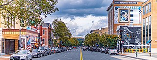
The U Street Corridor, sometimes called Cardozo/Shaw or Cardozo, is a commercial and residential district in Northwest Washington, D.C., most of which also constitutes the Greater U Street Historic District. It is centered along a nine-block stretch of U Street from 9th to 18th Streets, which from the 1920s until the 1960s was the city's black entertainment hub, called "Black Broadway" and "the heart of black culture in Washington, D.C.". After a period of decline following the 1968 riots, the economy picked up with the 1991 opening of the U Street Metro station. Subsequent gentrification diversified the population, which is 67% non-Hispanic White and 18% African American. Since 2013, thousands of residents have moved into new luxury apartment buildings. U Street is now promoted as a "happening" neighborhood for upscale, "hip", and "eclectic" dining and shopping, its live music and nightlife, as well as one of the most significant African American heritage districts in the country.

<span class="mw-page-title-main">Pleasant Plains (Washington, D.C.)</span> Neighborhood of Washington, D.C.

Pleasant Plains is a neighborhood in central Washington, D.C. largely occupied by Howard University. For this reason it is also sometimes referred to as Howard Town or, less frequently, Howard Village.

<span class="mw-page-title-main">Park View (Washington, D.C.)</span> Neighborhood of Washington, D.C.

Park View is a neighborhood in central Washington, D.C., immediately north of Howard University.

<span class="mw-page-title-main">Kingman Park</span> Place in the United States

Kingman Park is a residential neighborhood in the Northeast quadrant of Washington, D.C., the United States capital city. Kingman Park's boundaries are 15th Street NE to the west; C Street SE to the south; Benning Road to the north; and Anacostia Park to the east. The neighborhood is composed primarily of two-story brick rowhouses. Kingman Park is named after Brigadier General Dan Christie Kingman, the former head of the United States Army Corps of Engineers.

<span class="mw-page-title-main">Woodley Park (Washington, D.C.)</span> United States historic place

Woodley Park is a neighborhood in Northwest, Washington, DC. It is bounded on the north by Woodley Road and Klingle Road, on the east by the National Zoo and Rock Creek Park, on the south by Calvert Street, on the southwest by Cleveland Avenue, and on the west by 34th Street.

<span class="mw-page-title-main">Southwest Waterfront</span> Neighborhood in Washington, D.C., United States

The Southwest Waterfront is a neighborhood in Southwest Washington, D.C. The Southwest quadrant is the smallest of Washington's four quadrants, and the Southwest Waterfront is one of only two residential neighborhoods in the quadrant; the other is Bellevue, which, being east of the Anacostia River, is frequently, if mistakenly, regarded as being in Southeast

<span class="mw-page-title-main">Capitol View (Washington, D.C.)</span> Place in the United States

Capitol View is a neighborhood located in southeast Washington, D.C., in the United States. It is bounded by East Capitol Street to the north, Central Avenue SE to the southwest and south, and Southern Avenue SE to the southeast. Still overwhelmingly African-American, it is a thriving middle class neighborhood.

<span class="mw-page-title-main">Marshall Heights (Washington, D.C.)</span> Residential neighborhood in Washington, D

Marshall Heights is a residential neighborhood in Southeast Washington, D.C. It is bounded by East Capitol Street, Central Avenue SE, Southern Avenue, Fitch Street SE, and Benning Road SE. It was an undeveloped rural area occupied by extensive African American shanty towns, but the neighborhood received nationwide attention after a visit by First Lady Eleanor Roosevelt in 1934, which led to extensive infrastructure improvements and development for the first time. In the 1950s, Marshall Heights residents defeated national legislation designed to raze and redevelop the neighborhood. Queen Elizabeth II of the United Kingdom visited the area in 1991, at a time when Marshall Heights was in the throes of a violent crack cocaine epidemic. Limited redevelopment has occurred in the neighborhood, which was the site of two notorious child murders in 1973.

<span class="mw-page-title-main">Pleasant Hill (Washington, D.C.)</span> Place in the United States

Pleasant Hill is a neighborhood located in Ward 5 of Northeast Washington, D.C. Pleasant Hill is contained between Allison Street NE and Bates Road NE to the north, Taylor Street NE to the south, the Washington Metropolitan Area Red Line tracks to the east, and North Capitol Street NW to the west. Pleasant Hill borders the adjacent neighborhoods of Fort Totten (north), North Michigan Park (northeast), Michigan Park (east), University Heights (south), Petworth (west), Brightwood Park (northwest), and Park View (southwest). It is adjacent to the Catholic University of America and even houses its athletic facilities. Pleasant Hill houses the Catholic University of America's soccer and football fields as well as its Raymond A. DuFour Athletic Center.

<span class="mw-page-title-main">Sixteenth Street Heights</span>

Sixteenth Street Heights is a large neighborhood of rowhouses, duplexes, and American Craftsman and American Foursquare detached houses in Northwest Washington, D.C.

<span class="mw-page-title-main">Outline of Washington, D.C.</span> Overview of and topical guide to District of Columbia

The following outline is provided as an overview of and topical guide to District of Columbia:

References

  1. Ramanathan, Lavanya (November 14, 2016). "In the hot D.C. dining scene, the allure of the power restaurant is waning". The Washington Post . ISSN   0190-8286.
  2. Knowlton, Andrew (August 10, 2016). "Washington D.C. Is the Restaurant City of the Year". Bon Appétit .
  3. Muller, John (May 13, 2014). "In 1979, was your neighborhood "sound" or "distressed"?". Greater Greater Washington.
  4. Kelati, Haben (October 10, 2019). "Columbia Heights is a vibrant, diverse and, for DC, affordable neighborhood" . The Washington Post .
  5. Fox, Tara (January 22, 2021). "Why Columbia Heights is the perfect neighborhood for new D.C. residents". Common .
  6. Tom (September 30, 2013). "1903 Map of a Very Undeveloped Columbia Heights". Ghosts of DC.
  7. Hull, Dana (December 26, 1994). "D.C.'S FORGOTTEN NATIVE SON". The Washington Post .
  8. Roberts, Kim (October 6, 2020). By Broad Potomac's Shore: Great Poems from the Early Days of Our Nation's Capital.
  9. 1 2 "Streets Named Anew: Commissioners Fix Highway Nomenclature for Suburbs". The Washington Post . August 15, 1901. p. 2. ProQuest   144270485.
  10. "Street Car Extensions and a Columbia Heights Building Boom (1902)". Ghosts of DC. January 9, 2012.
  11. "Old Columbia Heights: Where the Streets Have New Names". Ghosts of DC. April 18, 2012.
  12. Hansen, Drew (October 22, 2019). "D.C. was very different the last time it hosted the World Series. Heck, the Pentagon didn't exist back then". American City Business Journals .
  13. Layton, Lyndsey (September 19, 1999). "Metro Goes to New Heights in District". The Washington Post .
  14. Montgomery, David (September 10, 1999). "Columbia Heights Rebirth Moves Forward". The Washington Post .
  15. "Amid gentrification, a 'new' D.C. emerges". Bradley Inman . December 5, 2016.
  16. "Target to Open First District Store in Columbia Heights". March 5, 2008.
  17. "Columbia Heights Case Study". University of Texas at Austin.
  18. "Urban Institute".
  19. "Report: D.C. white population grown rapidly in 3 ZIP codes". WJLA-TV . June 12, 2012.
  20. Neal, Arthur (February 21, 2017). "Local Food – Cooking Up Creative & Fresh Ideas for Healthy Communities". United States Department of Agriculture .
  21. Adler, Neil (October 27, 2006). "Dance institute to open new facility in D.C." American City Business Journals .
  22. "Banneker Community Center". District of Columbia Department of Parks and Recreation.
  23. "Banneker Pool". District of Columbia Department of Parks and Recreation.
  24. "Banneker Recreation Center". DC Preservation League.
  25. "Columbia Heights Green".
  26. "Columbia Heights Day Festival".
  27. GILBERT, SOPHIE (November 19, 2012). "WashingTelevision: Homeland Recap, Season Two, Episode Eight, "I'll Fly Away"". Washingtonian .
  28. Catlin, Roger (January 20, 2012). "Duke Ellington's Washington" . The Washington Post . ISSN   0190-8286.

38°55′30″N77°01′48″W / 38.925°N 77.03°W / 38.925; -77.03