Mount Pleasant | |
---|---|
Top: Mt. Pleasant Library (left) and Victorian townhomes (right); middle: Mt. Pleasant Street; bottom: Francis Asbury Memorial (left) and Mt. Pleasant St (right). | |
Coordinates: 38°55′43.3″N77°2′14.4″W / 38.928694°N 77.037333°W | |
Country | United States |
District | Washington, D.C. |
Quadrant | Northwest |
Ward | 1 |
Mount Pleasant is a neighborhood in Washington, D.C., located in Northwest D.C. The neighborhood is primarily residential, with restaurants and stores centered along a commercial corridor on Mt. Pleasant Street. Mount Pleasant is known for its unique identity and multicultural landscape, home to diverse groups such as the punk rock, the Peace Corps and Hispanic Washingtonian communities. [1]
The neighborhood was initially developed around the Mount Pleasant Hospital, which was built and operated during the American Civil War. Following the war, the largely rural was subdivided for real estate development. Following the advent of the D.C. streetcar system, Mt. Pleasant became Washington's first streetcar suburb and burgeoned as an affluent residential area until the mid-1940s. The neighborhood entered a period of decay following the white flight and the 1968 Washington, D.C. riots. Since the 2000s, Mount Pleasant has undergone increasing urban redevelopment and levels of gentrification. [2] [3]
In 1727, Charles Calvert, 5th Baron Baltimore, then governor of the Province of Maryland, awarded a land grant for present-day Mount Pleasant to James Holmead. This estate, later named "Pleasant Plains", included the territory of present-day neighborhoods of Adams Morgan, Columbia Heights, Meridian Hill, and Pleasant Plains (which only covers a portion of the original estate of the same name).
After the creation of the District of Columbia in 1791, Pleasant Plains estate became part of Washington County, but not part of the City of Washington.
In 1794 and 1796, noted Georgetown businessman Robert Peter conducted the first land surveys in the area and created maps for tracts of some of his land in Mount Pleasant for transactions with commissioners of the city. [4]
In 1861, William Selden, former Treasurer of the United States, owned 73 acres (300,000 m2) of land north of Pierce Mill Road, but having been a Confederate sympathizer, was forced was forced to sell his land at a low price and move back to Virginia. The purchaser was New England native Samuel P. Brown, [5] who built a house and also allowed the Mount Pleasant General Hospital to be constructed on his land.
After the American Civil War, Brown began selling his land in parcels. He named the area Mount Pleasant Village because it contained the land having the highest elevation within the original Pleasant Plains estate. Brown sold all of his land except for the parcel he retained around his house at 3351 Mount Pleasant Street, NW. [6]
In the 1870s, a horse-drawn streetcar began traveling between the Fourteenth and Park intersection to downtown Washington city, making this the first streetcar suburb in the District of Columbia. In 1878, Mount Pleasant merged into Washington when the city's boundaries became coterminous with those of the District.
In 1901, 16th Street NW was extended north of Florida Avenue, establishing the boundary of the neighborhood. [7] Mount Pleasant developed rapidly as a streetcar suburb after the expansion of the mechanized Washington streetcars along 16 1/2 Street (now Mount Pleasant Street) in 1903. [1] [7] In 1907, developer Fulton R. Gordon purchased large sections of the neighborhood, marketing lots as "Mount Pleasant Heights" with Robert E. Heater. [8] Many houses and apartment buildings were constructed between 1900 and 1925, primarily marketed to middle- to upper middle class people.
In 1925, the city built the Mount Pleasant Library, designed by Edward Lippincott Tilton and partially funded by philanthropist Andrew Carnegie. [9]
By 1927, all homeowners in the neighborhood had signed restrictive covenants forbidding sale to African Americans. By the time of World War II, many of the row houses were converted to boarding houses, many of which were occupied by single women. [1]
The neighborhood changed after the 1948 decision by the United States Supreme Court in the case of Shelley v. Kraemer , which struck down the restrictive covenants. After a Black Howard University professor moved into a prestigious Park Road home in 1950, some white residents began to leave the neighborhood. This White flight increased after the 1968 Washington, D.C. riots and by 1970 the neighborhood was 65% black. [1]
Beginning in the 1960s and increasing through the 1980s, immigrants from Central America, particularly from Intipucá, El Salvador, settled in the neighborhood. The new residents developed businesses catering to Hispanic and Latino Americans along commercial portions of Mount Pleasant Street. The neighborhood also attracted former Peace Corps workers.
In 1973, the Community of Christ, a lay-led Lutheran group dedicated to social justice, bought a large building on Mount Pleasant Street and made it available rent-free to peace activists, pro-immigrant groups and musicians. In the 1980s, the group house scene flourished. [1]
However, from the 1970s to the 1990s, the neighborhood suffered from the crack epidemic and the illegal drug trade was rampant. [10]
In 1987, the neighborhood was designated as a historic district. [11] [12] The neighborhood was majority-minority in 1990, with African Americans making up 36% of the population, Latinos 26%, and whites 35%.
In May 1991, the Washington, D.C. riot of 1991 erupted following the shooting of Daniel Enrique Gómez by an MPD officer. The riot, which injured twelve people and destroyed several buildings in the neighborhood, was a pivotal moment in the emergence of Latino activism in DC. [13] [14] In response, MPD Chief Isaac Fulwood, and city government began an outreach effort to the Latino population. [15]
The 2010 United States census, the ZIP Code 20010, which includes Mount Pleasant, was one of the "most whitened" areas of the country, with the percentage of non-Hispanic white residents increasing from 22% in 2000 to 46.7% in 2010. [16]
As of 2021, housing prices had risen significantly. [17]
It is bounded by Rock Creek Park to the north and west; Harvard Street NW to the south; and 16th Street NW to the east. It is north of Adams Morgan and west of Columbia Heights.
The population of Mount Pleasant, according to the 2010 census, was 10,459, down from 11,794 in 2000.
1990 | 2000 | 2010 | |
---|---|---|---|
white non-Hispanic | 35% | 35% | 50% |
black non-Hispanic | 36% | 27% | 26% |
Hispanic | 26% | 31% | 25% |
Asian/Pacific Islander | 3.0% | 6.3% | 5.6% |
Incomes rose during this time period.
1979 | 1989 | 1999 | 2010 | |
---|---|---|---|---|
Average family income (2010 $) | $75,980 | $77,704 | $90,838 | $130,790 |
Ratio to DC average | 98% | 83% | 89% | 114% |
The Mount Pleasant Historic District covers a variety of types and styles of building. The western portion of the neighborhood is a largely wooded residential enclave bounded on two sides by Rock Creek Park, just east of the National Zoo. Structures in this area are primarily row houses of Neoclassical architecture with rear porches. [18] The eastern side of the neighborhood, along 16th Street NW and Mount Pleasant Street, is marked by mid-rise apartment buildings.
The Eighteen Hundred Block Park Road, NW is notable for its 10 detached "suburban" houses on terraces overlooking the street.
The 12 buildings at 1644–1666 Park Road NW, designed by Appleton P. Clark Jr. in the style of Colonial Revival architecture, were completed in 1906. [9]
The Guglielmo Marconi Memorial is located at Marconi Plaza.
District of Columbia Public Library operates the Mount Pleasant Library. [19]
The neighborhood is served by the Mount Pleasant Line and the Crosstown Line buses. There is no Washington Metro station in the neighborhood, with the closest being located in Columbia Heights. [20]
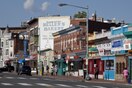
Adams Morgan, commonly abbreviated as AdMo, is a neighborhood in Washington, D.C., located in Northwest D.C. Adams Morgan is noted as a historic hub for counterculture and as an arts district. It is also known for its popular entertainment district and culinary scene, centered on both 18th Street and Columbia Road.
Northwest is the northwestern quadrant of Washington, D.C., the capital of the United States, and is located north of the National Mall and west of North Capitol Street. It is the largest of the four quadrants of the city, and it includes the central business district, the Federal Triangle, and the museums along the northern side of the National Mall, as well as many of the District's historic neighborhoods.
Columbia Heights is a neighborhood in Washington, D.C., located in Northwest D.C. The neighborhood is an important retail hub for the area, as home to DC USA mall and to numerous other restaurants and stores, primarily along the highly commercialized 14th Street. Columbia Heights is home to numerous historical landmarks, including Meridian Hill Park, National Baptist Memorial Church, All Souls Church, along with a number of embassy buildings.
Shaw is a neighborhood of Washington, D.C., located in the Northwest quadrant. Shaw is a major entertainment and retail hub, and much of the neighborhood is designated as a historic district, including the smaller Blagden Alley-Naylor Court Historic District. Shaw and the U Street Corridor have historically have been the city's hub for African-American social, cultural, and economic life.
14th Street NW/SW is a street in Northwest and Southwest quadrants of Washington, D.C., located 1.25 miles (2.01 km) west of the U.S. Capitol. It runs from the 14th Street Bridge north to Eastern Avenue.
The U Street Corridor or Greater U Street, sometimes known as Cardozo/Shaw, is a neighborhood in Washington, D.C., located in Northwest D.C. Centered along U Street, the neighborhood is one of Washington's most popular nightlife and entertainment districts, as well as one of the most significant African American heritage districts in the country.
The 1991 Washington, D.C., riot, sometimes referred to as the Mount Pleasant riot or Mount Pleasant Disturbance, occurred in May 1991, when rioting broke out in the Mount Pleasant neighborhood of Washington, D.C., in response to an African-American female police officer having shot a Salvadoran man in the chest following a Cinco de Mayo celebration.
Connecticut Avenue is a major thoroughfare in the Northwest quadrant of Washington, D.C., and suburban Montgomery County, Maryland. It is one of the diagonal avenues radiating from the White House, and the segment south of Florida Avenue was one of the original streets in Pierre (Peter) Charles L'Enfant's plan for Washington. A five-mile segment north of Rock Creek was built in the 1890s by a real-estate developer.
Streetcars in Washington, D.C. transported people across the city and region from 1862 until 1962.
Pleasant Plains is a neighborhood in central Washington, D.C. largely occupied by Howard University. For this reason it is also sometimes referred to as Howard Town or, less frequently, Howard Village.
Park View is a neighborhood in Washington, D.C., located in Northwest D.C. The neighborhood is primarily residential with its main commercial corridor of shops and restauarants located along Georgia Avenue.
Streetcars and interurbans operated in the Maryland suburbs of Washington, D.C., between 1890 and 1962.
Sixteenth Street Heights is a large neighborhood of rowhouses, duplexes, and American Craftsman and American Foursquare detached houses in Northwest Washington, D.C.
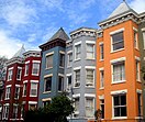
The Strivers' Section Historic District is a historic district located in the Dupont Circle neighborhood of Washington, D.C. Strivers' Section was historically an enclave of upper-middle-class African Americans, often community leaders, in the late 19th and early 20th centuries. It takes its name from a turn-of-the-20th-century writer who described the district as "the Striver's section, a community of Negro aristocracy." The name echoes that of Strivers' Row in Harlem, a New York City historic neighborhood of black professionals. The district is roughly bounded by Swann Street and the Dupont Circle Historic District on the south, Florida Avenue and the Washington Heights Historic District on the north and west, and the Sixteenth Street Historic District on the east.
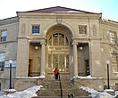
The Mount Pleasant Library at 1600 Lamont Street, NW in Washington, DC is a branch of the District of Columbia Public Library System that opened in May 1925, and is the third oldest public library building still in use in Washington.
The following outline is provided as an overview of and topical guide to the District of Columbia:
The Mount Vernon Triangle Historic District is a historic district in the Mount Vernon Triangle neighborhood of Washington, D.C., consisting of 22 contributing residential, commercial, and industrial buildings, and one known archaeological site. The area was once a working class neighborhood for mostly German immigrants and home to semi-industrial enterprises such as a dairy and an automobile repair shop. The Northern Liberty Market that once stood on the corner of 5th Street and K Street NW played a large role in spurring development in the surrounding area as did the streetcars on Massachusetts Avenue and New York Avenue.
The Kalorama Triangle Historic District is a mostly residential neighborhood and a historic district in the northwest quadrant of Washington, D.C. The entire Kalorama Triangle neighborhood was listed on the District of Columbia Inventory of Historic Sites (DCIHS) and National Register of Historic Places (NRHP) in 1987. In addition to individually listed landmarks in the neighborhood, the district is home to roughly 350 contributing properties. The neighborhood is roughly bounded by Connecticut Avenue to the west, Columbia Road to the east, and Calvert Street on the north.
Mount Vernon Triangle is a neighborhood and community improvement district in the northwest quadrant of Washington, D.C. The neighborhood is located adjacent to Mount Vernon Square. Originally a working-class neighborhood established in the 19th century, present-day Mount Vernon Triangle experienced a decline in the mid-20th century as it transitioned from residential to commercial and industrial use.
The Sheridan-Kalorama Historic District is a neighborhood and historic district located in the northwest quadrant of Washington, D.C. The boundaries of the historic district include Rock Creek Park to the north and west, P Street to the south, and 22nd Street and Florida Avenue to the east. On the southwestern edge of the neighborhood is a stretch of Embassy Row on Massachusetts Avenue. The other neighborhood and historic district that lies to the east of Sheridan-Kalorama is Kalorama Triangle Historic District. The two neighborhoods are divided by Connecticut Avenue. For many years both neighborhoods were geographically connected before the stretch of Connecticut Avenue was installed toward the Taft Bridge. Oftentimes, both neighborhoods are simply called "Kalorama" or "Kalorama Heights".