Fairlawn (Washington, D.C.)

Last updated
Fairlawn
Neighborhood
Map fairlawn dc.jpg
Map of Washington, D.C., with the Fairlawn neighborhood highlighted in red
Coordinates: 38°52′15″N076°58′44″W / 38.87083°N 76.97889°W / 38.87083; -76.97889 [1]
CountryUnited States
TerritoryWashington, D.C.
WardWard 8
Government
  Councilmember Trayon White

Fairlawn is a working class and middle class residential neighborhood in southeast Washington, D.C., United States. It is bounded by Interstate 295, Pennsylvania Avenue SE, Minnesota Avenue SE (between Pennsylvania Avenue SE and Naylor Road SE), Naylor Road SE (between Minnesota Avenue SE Good Hope Road SE), and Good Hope Road SE.

Contents

History

The Fairlawn neighborhood at the intersection of S st and 14th St SE in April 2018 Fairlawn Washington DC.jpg
The Fairlawn neighborhood at the intersection of S st and 14th St SE in April 2018

The Nacotchtank Native Americans were the first settlers to inhabit the area now known as Fairlawn, living and fishing along the nearby Anacostia River. [2] Captain John Smith was the first European to visit the region in A.D. 1612, naming the river the "Nacotchtank". [3] [4] [5] War and disease decimated the Nacochtank, and during the last 25 years of the 17th century the tribe ceased to exist as a functional unit and its few remaining members merged with other local Piscataway tribes. [4] [6] [7]

European settlement in Southeast Washington first occurred in 1662 at Blue Plains (now the site of the city's sewage treatment plant just to the west of the modern neighborhood of Bellevue), and at St. Elizabeth (now the site of St. Elizabeths Hospital psychiatric hospital) and Giesborough (now called Barry Farm) in 1663. [8] In 1663, Lord Baltimore granted ownership of the majority of the area on the south bank of the Anacostia River to George Thompson. [8]

The area became part of the District of Columbia in 1791. Congress passed the Residence Act of 1790 to establish a federally owned district in which would be built the new national capital, and George Washington picked the current site in 1791 (a choice ratified by Congress later that year). [9] William Marbury, a wealthy Georgetown merchant who later was a party in the landmark Marbury v. Madison Supreme Court case, purchased much of the "Chichester tract" some time in the late 18th or early 19th century. [4]

The growth of the Washington Navy Yard created the need to provide housing for the many new employees working at the facility, but little land was available for new construction in the area and housing prices were high. Consequently, in 1818, the privately owned "Upper Navy Yard Bridge" was built over the Anacostia River at 11th Street SE. [4] [10] This toll bridge was designed to permit easy access to Anacostia so that housing could be constructed on the eastern shore of the Anacostia River. [4] A road was built from the bridge to the town of Upper Marlboro, Maryland, and named Upper Marlborough Road (called Good Hope Road SE today), while another road ran roughly parallel to the river and was named Piscataway Road (then in the late 19th century "Asylum Road" and in the 20th century "Nichols Avenue", and is now Martin Luther King, Jr. Avenue SE). [11]

In the late 1820s or early 1830s, Marbury sold his land to Enoch Tucker, a farmer who rented out part of the land to tenant farmers and built his home near the intersection of Upper Marlborough Road and Piscataway Road. [4] Developers John Dobler, John Fox, and John W. Van Hook purchased the 240-acre (97.2 hectare) area immediately southwest of Fairlawn from Enoch Tucker on June 5, 1854, for $19,000 and immediately subdivided the property into lots for houses. [4] [7] [8] [12] [13] [14] Naming the area Uniontown (it is the neighborhood of Anacostia today), the development became Washington's first "suburban" community. [4] [13] [15] [16] [17] Van Hook (the lead developer) renamed streets in the area after former presidents: Upper Marlborough Road was now called "Harrison Street," and Piscataway Road now known as "Monroe Street". [4]

Dr. Arthur Christie, a wealthy Englishman, purchased 50 acres (20.25 hectares) of land on the north side of Harrison Street (now the lower portion of Good Hope Road SE) and named his estate Fairlawn. [4] The Fairlawn neighborhood derives its name from Christie's estate.

Racially restrictive covenants were used in early 20th century Fairlawn to keep the neighborhood exclusively white. A Washington Times real estate advertisement from October 1911 listed "NO NEGROES" as one of the neighborhood's supposed "advantages". [18]

Fairlawn remained largely undeveloped farm and woodland until 1940. Uniontown/Anacostia, Barry Farm, Congress Heights, and Randle Highlands were the focus of most housing and retail development. Even these communities remained isolated from one another, and most of the land between them was forest until World War II. [15] The oppressive need for housing during the war, brought about by a massive influx of federal workers to the capital, led to extensive building of homes in Fairlawn and the linking of the neighborhood with other parts of southeast D.C. [15]

The southern part of the Washington Metro's Green Line was originally designed to pass over the 11th Street Bridges to the intersection of Good Hope Road SE and Martin Luther King, Jr. Avenue SE. [19] [20] [21] [22] The site of the Anacostia Metro station at this intersection led to concerns that the Metro station would destroy the character of historic Anacostia and Fairlawn, and after pressure from the federal government Metro moved the site of the station to its current location on Howard Road SE. [19]

Notable establishments and place names in Fairlawn

Two public schools, Anacostia Senior High School and Kramer Middle School, are located in Fairlawn. Naylor Road School, a private school (grades K through 8), is also in the neighborhood. The Anacostia Branch of the District of Columbia Public Library is located in Fairlawn at 1800 Good Hope Road SE.

The large Marbury Plaza apartment building complex (2300 and 2330 Good Hope Road SE) in the Fairlawn neighborhood is named for William Marbury. Naylor Road SE is named for the Naylor family, whose farm constituted much of southern and southeastern portion of Fairlawn. Good Hope Road SE is named for the town of Good Hope, D.C., founded in 1820 around a tavern located near the current intersection of Good Hope Road SE and Alabama Avenue SE. [4] [11] [23]

The Anacostia Gateway building (1800 Martin Luther King, Jr. Avenue SE) was built by the District of Columbia in Fairlawn at the intersection of Martin Luther King, Jr. Avenue SE and Good Hope Road SE. [24] [25] As of January 2010, it houses the D.C. Department of Housing and Economic Development. The Anacostia Gateway building will be a terminus of the Anacostia Line of the DC Streetcar trolley system, under construction as of December 2009. [26]

The easternmost portion of Fort Dupont Park runs along T Street SE, Naylor Road SE, and Altamont Place SE in the Fairlawn area. The park adjoins Fort Stanton Park at Good Hope Road SE.

Related Research Articles

<span class="mw-page-title-main">Anacostia</span> Neighborhood in Washington, D.C.

Anacostia is a historic neighborhood in Southeast Washington, D.C. Its downtown is located at the intersection of Good Hope Road and Martin Luther King Jr. Avenue. It is located east of the Anacostia River, after which the neighborhood is named.

<span class="mw-page-title-main">Anacostia station</span> Washington Metro station

Anacostia station is a Washington Metro station in Washington, D.C., on the Green Line. The station is located in the Anacostia neighborhood of Southeast Washington, with entrances at Shannon Place and Howard Road near Martin Luther King, Jr. Avenue SE. The station serves as a hub for Metrobus routes in Southeast, Washington, D.C., and Prince George's County, Maryland.

<span class="mw-page-title-main">Southeast (Washington, D.C.)</span> Quadrant in the United States

Southeast is the southeastern quadrant of Washington, D.C., the capital of the United States, and is located south of East Capitol Street and east of South Capitol Street. It includes the Capitol Hill and Anacostia neighborhoods, the Navy Yard, the Joint Base Anacostia-Bolling (JBAB), the U.S. Marine Barracks, the Anacostia River waterfront, Eastern Market, the remains of several Civil War-era forts, historic St. Elizabeths Hospital, RFK Stadium, Nationals Park, and the Congressional Cemetery. It also contains a landmark known as "The Big Chair," located on Martin Luther King Jr. Avenue. The quadrant is split by the Anacostia River, with the portion that is west of the river sometimes referred to as "Near Southeast". Geographically, it is the second-smallest quadrant of the city.

Benning Road is a major traveled street in Washington, D.C., and Prince George's County, Maryland.

<span class="mw-page-title-main">Congress Heights</span> Neighborhood in Washington, D.C., U.S.

Congress Heights is a residential neighborhood in Southeast Washington, D.C., in the United States. The irregularly shaped neighborhood is bounded by the St. Elizabeths Hospital campus, Lebaum Street SE, 4th Street SE, and Newcomb Street SE on the northeast; Shepard Parkway and South Capitol Street on the west; Atlantic Street SE and 1st Street SE on the south; Oxon Run Parkway on the southeast; and Wheeler Street SE and Alabama Avenue SE on the east. Commercial development is heavy along Martin Luther King, Jr. Avenue and Malcolm X Avenue.

<span class="mw-page-title-main">South Capitol Street</span>

South Capitol Street is a major street dividing the southeast and southwest quadrants of Washington, D.C., in the United States. It runs south from the United States Capitol to the D.C.–Maryland line, intersecting with Southern Avenue. After it enters Maryland, the street becomes Indian Head Highway at the Eastover Shopping Center, a terminal or transfer point of many bus routes.

<span class="mw-page-title-main">11th Street Bridges</span> Complex of three bridges across the Anacostia River in Washington, D.C.

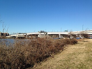
The 11th Street Bridges are a complex of three bridges across the Anacostia River in Washington, D.C., United States. The bridges convey Interstate 695 across the Anacostia to its southern terminus at Interstate 295 and DC 295. The bridges also connect the neighborhood of Anacostia with the rest of the city of Washington.

<span class="mw-page-title-main">Barney Circle</span> Neighborhood in the United States

Barney Circle is a small residential neighborhood located between the west bank of the Anacostia River and the eastern edge of Capitol Hill in southeast Washington, D.C., in the United States. The neighborhood is characterized by its sense of community, activism, walkability, and historic feel. The neighborhood's name derives from the eponymous former traffic circle Pennsylvania Avenue SE just before it crosses the John Philip Sousa Bridge over the Anacostia. The traffic circle is named for Commodore Joshua Barney, Commander of the Chesapeake Bay Flotilla in the War of 1812.

<span class="mw-page-title-main">Hillcrest (Washington, D.C.)</span> Neighborhood in Ward 7, United States

Hillcrest is a residential neighborhood in the southeast quadrant of Washington, D.C., United States. Hillcrest is located on the District-Maryland line in Ward 7, east of the Anacostia River.

<span class="mw-page-title-main">Good Hope (Washington, D.C.)</span> Neighborhood in Ward 7, United States

Good Hope is a residential neighborhood in southeast Washington, D.C., near Anacostia. The neighborhood is generally middle class and is dominated by single-family detached and semi-detached homes. The year-round Fort Dupont Ice Arena skating rink and the Smithsonian Institution's Anacostia Museum are nearby. Good Hope is bounded by Fort Stanton Park to the north, Alabama Avenue SE to the south, Naylor Road SE to the west, and Branch Avenue SE to the east. The proposed Skyland Shopping Center redevelopment project is within the boundaries of the neighborhood.

<span class="mw-page-title-main">Greenway (Washington, D.C.)</span> Neighborhood in Ward 7, United States

Greenway is a residential neighborhood in Southeast Washington, D.C., in the United States. The neighborhood is bounded by East Capitol Street to the north, Pennsylvania Avenue SE to the south, Interstate 295 to the west, and Minnesota Avenue to the east.

<span class="mw-page-title-main">Pennsylvania Avenue Line (Washington, D.C.)</span> Daily Metrobus route in Washington, D.C., United States

The Pennsylvania Avenue Line, designated Routes 32 and 36, is a daily Metrobus route in Washington, D.C., Operating between the Southern Avenue station or Naylor Road station of the Green Line of the Washington Metro and Potomac Park. Until the 1960s, it was a streetcar line, opened in 1862 by the Washington and Georgetown Railroad as the first line in the city.

The Anacostia and Potomac River Railroad Company was the fourth streetcar company to operate in Washington, D.C., and the first to cross the Anacostia River. It was chartered in 1870, authorized by Congress in 1875 and built later that year. The line ran from the Arsenal to Union Town. It expanded, adding lines to Congressional Cemetery, Central Market and to the Government Hospital for the Insane; and in the late 1890s it purchased two other companies and expanded their lines. It was reluctant to change its operations, but in 1900 it relented to pressure and became the last company to switch from horsecars to electric streetcars. It was one of the few companies not to be swept up by the two major streetcar companies at the turn of the 20th century, but it could not hold out forever and on August 31, 1912, it was purchased by the Washington Railway and Electric Company and ceased to operate as a unique entity.

<span class="mw-page-title-main">DC Streetcar</span> Streetcar system in Washington, D.C.

The DC Streetcar is a surface streetcar network in Washington, D.C. As of 2017, it consists of only one line: a 2.2-mile (3.5 km) segment running in mixed traffic along H Street and Benning Road in the city's Northeast quadrant.

<span class="mw-page-title-main">Anacostia Historic District</span> Historic district in Washington, D.C., United States

The Anacostia Historic District is a historic district in the city of Washington, D.C., comprising approximately 20 squares and about 550 buildings built between 1854 and 1930. The Anacostia Historic District was added to the National Register of Historic Places in 1978. "The architectural character of the Anacostia area is unique in Washington. Nowhere else in the District of Columbia does there exist such a collection of late-19th and early-20th century small-scale frame and brick working-class housing."

<span class="mw-page-title-main">Martin Luther King Jr. Avenue</span> Street in District of Columbia, USA

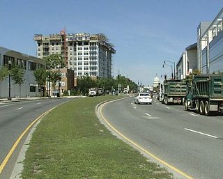
Martin Luther King Jr. Avenue is a major street in the District of Columbia traversing through both the Southwest and Southeast quadrants.

<span class="mw-page-title-main">Pennsylvania Avenue Bridge (1890)</span> Bridge in United States of America

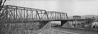
The Pennsylvania Avenue Bridge was a crossing of the Anacostia River in Washington, DC at the site of the present John Philip Sousa Bridge. It was constructed in 1890 and demolished around 1939.

<span class="mw-page-title-main">Anacostia Line</span>

The Anacostia Line is a partially constructed line of the DC Streetcar, never put into service, intended to connect the Anacostia neighborhood with Joint Base Anacostia–Bolling. Construction occurred in 2009 and 2010, but was terminated before the line was complete.

<span class="mw-page-title-main">Chillum Road Line</span> Bus route in Washington

The Chillum Road Line, designated as Route F1 is a daily bus route operated by the Washington Metropolitan Area Transit Authority between Cheverly station of the Orange Line of the Washington Metro and Takoma station of the Red Line. The line operates every 25–38 minutes during peak hours, 60 minutes during weekday off peak hours, and 58–62 minutes on the weekends. Trips roughly take 50–60 minutes.

The U Street–Garfield Line, designated Routes 90 and 92, are daily bus routes operated by the Washington Metropolitan Area Transit Authority between Anacostia station (90) or Congress Heights station (92) of the Green Line of the Washington Metro and Duke Ellington Bridge (90) in Adams Morgan or Reeves Center / U Street station (92) of the Green Line of the Washington Metro. Late Night & Early Morning 92 trips are extended to Duke Ellington Bridge. The lines operate every 12 - 24 minutes between 7 AM and 9 PM, and 15 - 30 minutes at all other times. Route 90 and 92 trips are roughly 60 to 70 minutes.

References

  1. U.S. Geological Survey Geographic Names Information System: Fairlawn (Washington, D.C.)
  2. Humphrey, Robert L. and Chambers, Mary Elizabeth. "Ancient Washington: American Indian Cultures of the Potomac Valley." G.W. Studies. 1977.
  3. Rountree, Helen C.; Clark, Wayne E.; and Mountford, Kent. John Smith's Chesapeake Voyages, 1607–1609. Charlotte, Va.: University of Virginia Press, 2007. ISBN   0-8139-2644-0
  4. 1 2 3 4 5 6 7 8 9 10 11 Burr, Charles R. "A Brief History of Anacostia, Its Name, Origin, and Progress." Records of the Columbia Historical Society. 1920.
  5. There is some evidence that Smith was not the first European to visit the area. A Spanish vessel may have brought European explorers to the Anacostia River around 1550 C.E. See: Bryan, A History of the National Capital..., 1914, p. 47.
  6. Williams, Brett. "A River Runs Through Us." American Anthropologist. 103:2 (June 2001).
  7. 1 2 Cantwell, Thomas J. "Anacostia: Strength in Adversity." Records of the Columbia Historical Society, Washington, D.C. 1973/1974.
  8. 1 2 3 Bryan, Wilhelmus Bogart. A History of the National Capital from Its Foundation Through the Period of the Adoption of the Organic Act. New York: The Macmillan Company, 1914.
  9. Crew, Harvey W.; Webb, William Bensing; and Wooldridge, John. Centennial History of the City of Washington, D.C. Dayton, Ohio: United Brethren Publishing House, 1892.
  10. Croggon, James. "Old 'Burnt Bridge'". Evening Star. July 7, 1907.
  11. 1 2 Senkevitch, Anatole. Old Anacostia, Washington, D.C.: A Study of Community Preservation Resources. School of Architecture, University of Maryland. 1975.
  12. "A New Historic District." Washington Post. March 5, 1978.
  13. 1 2 "Anacostia Historic District - National Register of Historic Places Inventory - Nomination Form." National Park Service. United States Department of the Interior. October 10, 1978.
  14. Gillette, Howard. Between Justice and Beauty: Race, Planning, and the Failure of Urban Policy in Washington. Philadelphia, Pa.: University of Pennsylvania Press, 2006. ISBN   0-8122-1958-9
  15. 1 2 3 Benedetto, Robert; Donovan, Jane; and Du Vall, Kathleen. Historical Dictionary of Washington. New York: Rowman & Littlefield, 2003. ISBN   0-8108-4094-4
  16. Evelyn, Douglas E.; Dickson, Paul; and Ackerman, S.J. On This Spot: Pinpointing the Past in Washington, D.C. 3rd rev. ed. Sterling, Va.: Capital Books, 2008. ISBN   1-933102-70-5
  17. Thompson, John and Nowitz, Richard. National Geographic Traveler Washington. 3rd ed. Washington, D.C.: National Geographic Books, 2008. ISBN   1-4262-0225-3
  18. "The rise and demise of racially restrictive covenants in Bloomingdale". DC Policy Center. Retrieved 2021-11-24.
  19. 1 2 Sisler, Peter F. "Decades of Frustrating Debate Kept Green Line Sidetracked." Washington Times. December 27, 1991.
  20. Burgess, John. "Metro to Halt Start of Leg To Rosecroft." Washington Post. March 18, 1982.
  21. Feaver, Douglas. "Metro Choices Detailed." Washington Post. October 18, 1977.
  22. Vesey, Tom. "Green Line War Heats Up Again." Washington Post. June 23, 1982.
  23. Anacostia Historic District. D.C. Historic Preservation Office. Office of Planning, District of Columbia. Washington, D.C.: March 2007. Archived 2010-01-08 at the Wayback Machine Accessed 2009-12-26.
  24. Goldman, Melanie D. "Anacostia Gateway to Anchor Town Center Project." Washington Business Journal. May 12, 2000; O'Connell, Jonathan. "The Next Hot Spot: Anacostia." Washington Business Journal. August 15, 2008.
  25. Hedgpeth, Dana. "Moving Metro Office Could Spur Growth." Washington Post. August 8, 2005.
  26. Sun, Lena H. "Streetcars Could Be Running on D.C. Roads by Late Next Year." Washington Post. July 13, 2008; Young, Joseph. "Streetcars Set to Run Again in the District." Washington Times. August 26, 2009; Hohmann, James. "Anacostia Streetcar Track Installation Begins." Washington Post. September 20, 2009.