Glover Park

Last updated
Glover Park
Benton Street.JPG
Benton Street in Glover Park (2006)
DC Neighborhoods - Glover Park.svg
Map of Washington, D.C., with Glover Park highlighted in red
Coordinates: 38°55′21″N77°04′29″W / 38.9225°N 77.074722°W / 38.9225; -77.074722 Coordinates: 38°55′21″N77°04′29″W / 38.9225°N 77.074722°W / 38.9225; -77.074722
Country United States
District Washington, D.C.
WardWard 3
Government
  Councilmember Matthew Frumin

Glover Park is a neighborhood in northwest Washington, D.C., about a half mile north of Georgetown and just west of the United States Naval Observatory and Number One Observatory Circle (the Vice President's mansion). Every morning and evening, Glover Park residents can hear the Naval Observatory play the sounding of colors synchronized to the nation's Master Clock. [1] It is named after Charles Carroll Glover.

Contents

Location

The neighborhood's western border is an extension of Rock Creek Park called Glover-Archbold Park (named after Charles Carroll Glover and Anne Mills Archbold, who each donated part of the land). Glover Park's northern border is Fulton Street, near the Washington National Cathedral, and the Cathedral Heights neighborhood. Its southern border is Whitehaven Park, another branch of Rock Creek Park. Beyond Whitehaven to the south lies the Burleith neighborhood and Georgetown University while to the east of the neighborhood lies Woodley Park.

Description

Local claims to fame include several embassies, including the sprawling Embassy of Russia in Washington (with its legendary tunnels beneath) and the Visa Office of the Chinese embassy. Wisconsin Avenue in Glover Park is home to a variety of restaurants and other businesses. Guy Mason Park is between Wisconsin Avenue and the Naval Observatory just south of Calvert Street. It is the location of a softball diamond, a playground for small children, and an unofficial enclosed dog park. Guy Mason Park is also the location of the annual Glover Park Day festival, held in early June.

Hall Place in Glover Park Hall Pl.jpg
Hall Place in Glover Park

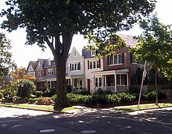
Housing in Glover Park is a mix of apartment buildings and porch-front rowhouses built in the 1920s and 1930s. The neighborhood's elementary school, Benjamin Stoddert Elementary, is one of the most highly rated schools in the District. Neighborhood Cluster 14 (Glover Park, Cathedral Heights, and McLean Gardens) has one of the lowest crime rates in the District. Glover Park residents harvest crops from small, individual garden plots in the two Victory gardens leased from the National Park Service. On the field adjacent to Stoddert Elementary, Glover Park has hosted the Glover Park Co-ed Softball League, one of the Washington Metropolitan Area's most well-known co-ed slow pitch softball leagues, since 1982. DC Stoddert Soccer, a nonprofit league with over 5,000 players, was founded on this field and takes its name from it.

The neighborhood is named for Washingtonian Charles Carroll Glover, an influential late 19th and early 20th century banker and philanthropist. He is credited with the creation of the city's Rock Creek Park system and with an influential role in the creation of Embassy Row through generous land donations. He is also considered the father of the National Zoo and Rock Creek Parkway.

39th Place in Glover Park 39th Place in Glover Park.jpg
39th Place in Glover Park

The family of Charles Glover pronounces their last name so that it rhymes with "cover." However, many people in Washington, including longtime residents, newcomers, and even the Washington Metropolitan Area Transit Authority (WMATA) pronounce the name so it rhymes with "clover." [2]

Education

The local public schools are operated by the District of Columbia Public Schools.

The area is zoned to:

See also

Related Research Articles

<span class="mw-page-title-main">Rock Creek Park</span> Urban park in Washington, D.C., U.S.

Rock Creek Park is a large urban park that bisects the Northwest quadrant of Washington, D.C. The park was created by an Act of Congress in 1890 and today is administered by the National Park Service. In addition to the park proper, the Rock Creek administrative unit of the National Park Service administers various other federally owned properties in the District of Columbia located to the north and west of the National Mall, including Meridian Hill Park on 16th Street, N.W., the Old Stone House in Georgetown, and certain of the Fort Circle Parks, a series of batteries and forts encircling the District of Columbia for its defense during the U.S. Civil War.

<span class="mw-page-title-main">Georgetown (Washington, D.C.)</span> Place in the United States

Georgetown is a historic neighborhood, and commercial and entertainment district located in Northwest Washington, D.C., situated along the Potomac River. Founded in 1751 in the Province of Maryland, the port of Georgetown predated the establishment of the federal district and the City of Washington by 40 years. Georgetown remained a separate municipality until 1871 when the United States Congress created a new consolidated government for the whole District of Columbia. A separate act, passed in 1895, specifically repealed Georgetown's remaining local ordinances and renamed Georgetown's streets to conform with those in the City of Washington.

<span class="mw-page-title-main">Benjamin Stoddert</span> 1st United States Secretary of the Navy

Benjamin Stoddert was the first United States Secretary of the Navy from 1 May 1798 to 31 March 1801.

<span class="mw-page-title-main">Capitol Hill</span> United States historic place

Capitol Hill, in addition to being a metonym for the United States Congress, is the largest historic residential neighborhood in Washington, D.C., stretching easterly in front of the United States Capitol along wide avenues. It is one of the oldest residential neighborhoods in Washington, D.C., and, with roughly 35,000 people in just under 2 square miles (5 km2), it is also one of the most densely populated.

<span class="mw-page-title-main">Adams Morgan</span> Neighborhood of Washington, D.C.

Adams Morgan is a neighborhood in Northwest Washington, D.C., centered at the intersection of 18th Street NW and Columbia Road, about 1.5 miles (2.54 km) north of the White House. Notable establishments in the neighborhood include the Washington Hilton and Madam's Organ Blues Bar. Notable residential buildings include Euclid Apartments, Fuller House, Park Tower, Meridian Mansions, and the Pink Palace. Embassies in the neighborhood include the Embassy of Lithuania, the Embassy of Poland, the Embassy of the Central African Republic, the Embassy of Gabon and the Embassy of Cuba. Notable public artwork in Adams Morgan includes Carry the Rainbow on Your Shoulders, The Servant Christ, and The Mama Ayesha's Restaurant Presidential Mural.

<span class="mw-page-title-main">Burleith</span> Neighborhood in Washington, D.C., United States

Burleith is a neighborhood in Washington, D.C., United States. It is bordered by 35th Street NW to the east, Reservoir Road NW and the historic Georgetown district to the south, Whitehaven Park to the north, and Glover Archbold Park to the west. The neighborhood is home to the Duke Ellington School of the Arts and the Washington International School.

<span class="mw-page-title-main">Northwest (Washington, D.C.)</span> Place in the United States

Northwest is the northwestern quadrant of Washington, D.C., the capital of the United States, and is located north of the National Mall and west of North Capitol Street. It is the largest of the four quadrants of the city, and it includes the central business district, the Federal Triangle, and the museums along the northern side of the National Mall, as well as many of the District's historic neighborhoods.

<span class="mw-page-title-main">Cleveland Park</span> Neighborhood in Washington, D.C.

Cleveland Park is a residential neighborhood in the Northwest quadrant of Washington, D.C. It is located at 38°56′11″N77°3′58″W and bounded approximately by Rock Creek Park to the east, Wisconsin and Idaho Avenues to the west, Klingle and Woodley Roads to the south, and Rodman and Tilden Streets to the north. Its main commercial corridor lies along Connecticut Avenue NW, where the eponymous Cleveland Park station of the Washington Metro's Red Line can be found; another commercial corridor lies along Wisconsin Avenue. The neighborhood is known for its many late 19th century homes and the historic Art Deco Uptown Theater. It is also home to the William L. Slayton House and the Park and Shop, built in 1930 and one of the earliest strip malls.

<span class="mw-page-title-main">Shepherd Park</span>

Shepherd Park is a neighborhood in the northwest quadrant of Washington, D.C. In the years following World War II, restrictive covenants which had prevented Jews and African Americans from purchasing homes in the neighborhood were no longer enforced, and the neighborhood became largely Jewish and African American. Over the past 40 years, the Jewish population of the neighborhood has declined, but the neighborhood has continued to support a thriving upper and middle class African American community. The Shepherd Park Citizens Association and Neighbors Inc. led efforts to stem white flight from the neighborhood in the 1960s and 1970s, and it has remained a continuously integrated neighborhood, with very active and inclusive civic groups.

<span class="mw-page-title-main">Kalorama (Washington, D.C.)</span> Neighborhood of Washington, D.C.

Kalorama is a neighborhood in Northwest Washington, D.C., United States. It includes the Kalorama Triangle Historic District and Sheridan-Kalorama Historic District. It is named after the Kalorama mansion.

<span class="mw-page-title-main">Chevy Chase (Washington, D.C.)</span> Place in the United States

Chevy Chase is a neighborhood in northwest Washington, D.C. It borders Chevy Chase, Maryland, a collection of similarly affluent neighborhoods.

<span class="mw-page-title-main">Takoma (Washington, D.C.)</span> Neighborhood of Washington, D.C.

Takoma, Washington, D.C., is a neighborhood in Washington, D.C. It is located in Advisory Neighborhood Commission 4B, in the District's Fourth Ward, within the northwest quadrant. It borders the city of Takoma Park, Maryland.

<span class="mw-page-title-main">Massachusetts Avenue (Washington, D.C.)</span> Major road in Washington, D.C., U.S.

Massachusetts Avenue is a major diagonal transverse road in Washington, D.C., and the Massachusetts Avenue Historic District is a historic district that includes part of it.

<span class="mw-page-title-main">Petworth (Washington, D.C.)</span> Place in District of Columbia, United States

Petworth is a residential neighborhood in the Northwest quadrant of Washington, D.C. It is bounded to the east by the Armed Forces Retirement Home and Rock Creek Cemetery, to the west by Arkansas Avenue NW, to the south by Rock Creek Church Road NW and Spring Road NW, and to the north by Kennedy Street NW.

<span class="mw-page-title-main">Woodley Park (Washington, D.C.)</span> United States historic place

Woodley Park is a neighborhood in Northwest, Washington, DC. It is bounded on the north by Woodley Road and Klingle Road, on the east by the National Zoo and Rock Creek Park, on the south by Calvert Street, on the southwest by Cleveland Avenue, and on the west by 34th Street.

<span class="mw-page-title-main">Cathedral Heights</span>

Cathedral Heights is a small, affluent residential neighborhood located in the upper Northwest quadrant of Washington, D.C. It is approximately bounded by Woodley Road to the north, Fulton Street to the south, Wisconsin Avenue to the east, and Glover Archbold Park and Idaho Avenue to the west.

<span class="mw-page-title-main">Observatory Circle (Washington, D.C.)</span> Place in the United States

Observatory Circle is a neighborhood in Northwest Washington, D.C., dominated by the circle of the same name — the grounds of the United States Naval Observatory and the official residence of the U.S. vice president.

<span class="mw-page-title-main">P Street</span> Street in Washington, D.C., United States

P Street refers to four different streets within the city of Washington, D.C. The streets were named by President George Washington in 1791 as part of a general street naming program, in which east–west running streets were named alphabetically and north–south running streets numerically.

<span class="mw-page-title-main">Glover-Archbold Park</span> Park in Washington, D.C., U.S.

Glover Archbold Park is a 183-acre, frequently-used, quasi-natural, stream-valley park in Northwest, Washington, D.C., on the western edge of Georgetown University and the Burleith-Hillandale, Glover Park, McLean Gardens, and Westchester neighborhoods. The park includes a historical Victory Garden adjacent to W Street, N.W as well as Foundry Branch from Van Ness Street, to Canal Road, along the Potomac River. Several temporary streams, some originating from springs, flow into Foundry Branch. One of the "finger parks" of Rock Creek Park, the Glover-Archbold Park is administered by the National Park Service (NPS). The removal of anything from the natural areas of the park is prohibited. In addition, to aid in preservation, the NPS prohibits off-leash dogs, bicycles, and motorized vehicles in the park. Dog walkers, hikers, and joggers often visit the park. Nature, Gardens, and Georgetown (2006) includes a chapter on the park.

<span class="mw-page-title-main">Charles C. Glover</span> American banker and philanthropist (1846–1936)

Charles Carroll Glover was an American banker and philanthropist who made major contributions to the modern landscape of Washington, D.C. in the late 19th and early 20th centuries. He was President of Riggs Bank, an effective advocate of urban beautification in Washington under the influence of the City Beautiful movement, and a generous donor of land and money for Washington's parks and monuments.

References

  1. "Nation's Master Clock Used to Trigger Colors". United States Navy. 10 July 2009. Retrieved 20 November 2010.
  2. "Glover Park in Washington DC".
  3. "Elementary Schools Archived 2017-02-12 at the Wayback Machine " (2016-2017 School Year). District of Columbia Public Schools. Retrieved on May 27, 2018.
  4. "Middle School Boundary Map Archived 2017-02-11 at the Wayback Machine " (2016-2017 School Year). District of Columbia Public Schools. Retrieved on May 27, 2018.
  5. "High School Boundary Map Archived 2017-01-31 at the Wayback Machine " (2016-2017 School Year). District of Columbia Public Schools. Retrieved on May 27, 2018.