
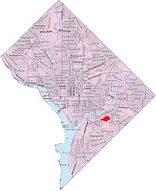
Minnesota Avenue station is an island-platformed Washington Metro station in the Central Northeast/Mahaning Heights neighborhood of Northeast Washington, D.C., United States. The station was opened on November 20, 1978, and is operated by the Washington Metropolitan Area Transit Authority (WMATA).

Congress Heights station is an island-platformed Washington Metro station situated in the Congress Heights neighborhood of Washington, D.C., United States. Opened on January 13, 2001, the station is operated by the Washington Metropolitan Area Transit Authority (WMATA). Serving only the Green Line, it is positioned at the intersection of Alabama Avenue and 13th Street, beneath St. Elizabeths Hospital. Congress Heights marks the terminus of the Green Line in the District of Columbia as it extends southeastward.

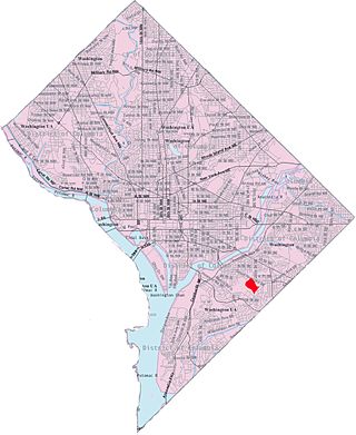
Southeast is the southeastern quadrant of Washington, D.C., the capital of the United States, and is located south of East Capitol Street and east of South Capitol Street. It includes the Capitol Hill and Anacostia neighborhoods, the Navy Yard, the Joint Base Anacostia-Bolling (JBAB), the U.S. Marine Barracks, the Anacostia River waterfront, Eastern Market, the remains of several Civil War-era forts, historic St. Elizabeths Hospital, RFK Stadium, Nationals Park, and the Congressional Cemetery. It also contains a landmark known as "The Big Chair," located on Martin Luther King Jr. Avenue. The quadrant is split by the Anacostia River, with the portion that is west of the river sometimes referred to as "Near Southeast". Geographically, it is the second-smallest quadrant of the city.

Deanwood is a neighborhood in Northeast Washington, D.C., bounded by Eastern Avenue to the northeast, Kenilworth Avenue to the northwest, Division Avenue to the southeast, and Nannie Helen Burroughs Avenue to the south.

The name "M Street" refers to two major roads in the United States capital of Washington, D.C. Because of the Cartesian coordinate system used to name streets in Washington, the name "M Street" can be used to refer to any east-west street located twelve blocks north or south of the dome of the United States Capitol. Thus, in all four quadrants of the city there are streets called "M Street", which are disambiguated by quadrant designations, namely, M Street NW, NE, SW, and SE.
The Rhode Island Avenue Trolley Trail is a 3.8-mile (6.1 km) long rail trail within the Cities of College Park Maryland, Riverdale Park Maryland and Hyattsville Maryland. It is located within the Anacostia Trails Heritage Area.
Benning Ridge is a residential neighborhood located in Southeast Washington, D.C. It is bounded by Fort Chaplin Park to the northwest, Southern Avenue to the south, Benning Road to the east, and Ridge Road SE to the west. Benning Ridge is an unusual neighborhood for its location east of the Anacostia River: although it is surrounded by working-class and low-income African American neighborhoods, Benning Ridge is rather affluent, with a diverse population of middle- and upper-middle-class white and black residents. As of 2015 the neighbourhood was one of the top ten most liberal neighbourhoods in Washington D.C..
Burrville is a neighborhood located in Northeast Washington, D.C., east of the Anacostia River. It is triangular in area, bounded by Nannie Helen Burroughs Avenue to the south, Division Avenue to the northwest, and Eastern Avenue to the northeast.

Eastland Gardens is a small residential neighborhood, located in northeast Washington, D.C. It is bounded by Eastern Avenue NE to the north, the Watts Branch Tributary to the south, CSX Transportation tracks to the east and the Anacostia River to the west.

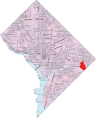
Fort Dupont is a residential neighborhood located in southeast Washington, D.C., east of the Anacostia River. It is bounded by East Capitol Street to the north, Fort Dupont Park to the south, Minnesota Avenue to the west, and Fort Chaplin Park to the east and northeast. Fort Dupont has a population of approximately 7,050.

Garfield Heights is a residential neighborhood in Southeast Bounded by Suitland Parkway SE, Alabama Avenue SE, 28th Street SE, Gainesville Street SE, Naylor Road SE, and Southern Avenue SE.Washington, D.C., bordering Prince George's County, Maryland. Garfield Heights contains both apartment units and single-family detached houses.

Dupont Park is a residential neighborhood located in southeast Washington, D.C. It is bounded by Fort Dupont Park to the north, Pennsylvania Avenue SE to the south, Branch Avenue to the west, and Fort Davis Park to the east. The neighborhood civic association uses Fairlawn Avenue and the Anacostia Freeway as the western boundary of the neighborhood.

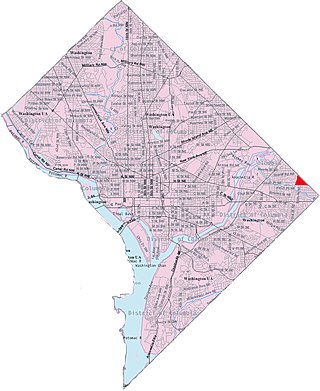
Northeast Boundary is small neighborhood located in the northeast quadrant of Washington, D.C., in the United States. Along with the Capitol View neighborhood, it is the easternmost neighborhood of the District of Columbia.

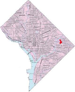
Kenilworth is a residential neighborhood in Northeast Washington, D.C., located on the eastern bank of the Anacostia River and just inside the D.C.-Maryland border. A large public housing complex, Kenilworth Courts, dominates the area. The neighborhood is famous for the Kenilworth Park and Aquatic Gardens, a national park whose centerpiece is a series of ponds carved out of Anacostia River marshland. Visitors come especially during June and July to see the beautiful blooming water lilies and lotus flowers. In 1895 the name “Kenilworth” was first applied to the area by white real estate developer Allen Mallery, who named this neighborhood after Kenilworth Castle in England, the ruins of which can still be seen today in Warwickshire. Kenilworth Park, which includes the Kenilworth-Parkside Recreation Center, also carries the neighborhood name, though most of the park's area is actually located adjacent to the modern neighborhoods of Parkside and Eastland Gardens.
Mayfair or Parkside-Mayfair is a residential neighborhood in Northeast Washington, D.C., United States., on the eastern bank of the Anacostia River. It is bounded by Jay Street NE, Foote Street NE, Kenilworth Terrace NE, Anacostia Avenue NE, and Kenilworth Avenue NE.. Mayfair is encircled by Jay Street and Hayes St., which met at the back of the neighborhood.
Park Naylor is a residential neighborhood located in southeast Washington, D.C. It takes its name from its northern and eastern borders, Naylor Road and Fort Stanton Park. Park Naylor's other boundaries are Minnesota Avenue to the west, and Good Hope Road SE to the south. Also see article on Anacostia.
Skyland is a neighborhood in Southeast Washington, D.C. It is bounded by Good Hope Road to the northeast, Alabama Avenue to the southeast, and Fort Stanton Park to the south and west. It is part of Ward 8. Also see article on the Anacostia neighborhood.

Randle Highlands is a neighborhood in Southeast Washington, D.C., east of the Anacostia River.

Penn Branch is a neighborhood in Southeast Washington, D.C., east of the Anacostia River. It is bounded by Pennsylvania Avenue SE to the south; Pope Branch Park and Pope Creek to the north; Branch Avenue to the west; and Fort Davis Park to the east. ‘Penn Branch’, takes its name from its location at the intersection of two major thoroughfares, Pennsylvania and Branch Avenue.
Hickey Run is a tributary stream of the Anacostia River in Washington, D.C.

