Woodmore is an unincorporated area and census-designated place in Prince George's County, Maryland, United States. Per the 2020 census, the population was 4,513. The CDP is located within the boundaries of Route 193 to the west, Church Road to the east, Route 214 to the south and Route 50 to the north. Woodmore Road runs east and west through the center. It contains a large gated community and country club, developments of Woodmore Meadows, and Woodmore South on the south side, as well as various other custom built homes and farmland.

Stadium–Armory station is a Washington Metro station in Southeast, Washington, D.C. It is located at the border of the Barney Circle and Kingman Park neighborhoods. The station was opened on July 1, 1977, and is operated by the Washington Metropolitan Area Transit Authority (WMATA). Stadium–Armory serves the Blue, Orange and Silver Lines.
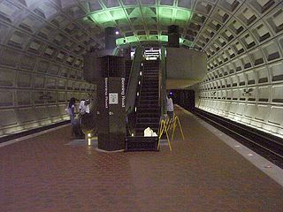
Benning Road station is an island-platformed Washington Metro station in the Benning Ridge neighborhood of Northeast Washington, D.C., United States. The station was opened on November 22, 1980, and is operated by the Washington Metropolitan Area Transit Authority (WMATA). Providing service for the Blue and Silver Lines, the station is located in a residential area near the intersection of Benning Road and East Capitol Street. It is the first station after the Blue and Silver Lines diverge from the Orange Line east of the Anacostia River, and also the last station in the District of Columbia going east.

Southeast is the southeastern quadrant of Washington, D.C., the capital of the United States, and is located south of East Capitol Street and east of South Capitol Street. It includes the Capitol Hill and Anacostia neighborhoods, the Navy Yard, the Joint Base Anacostia-Bolling (JBAB), the U.S. Marine Barracks, the Anacostia River waterfront, Eastern Market, the remains of several Civil War-era forts, historic St. Elizabeths Hospital, RFK Stadium, Nationals Park, and the Congressional Cemetery. It also contains a landmark known as "The Big Chair," located on Martin Luther King Jr. Avenue. The quadrant is split by the Anacostia River, with the portion that is west of the river sometimes referred to as "Near Southeast". Geographically, it is the second-smallest quadrant of the city.
Northeast is the northeastern quadrant of Washington, D.C., the capital of the United States. It encompasses the area located north of East Capitol Street and east of North Capitol Street.

Columbia Heights is a neighborhood in Washington, D.C., located in Northwest D.C. Bounded by 16th Street NW, W Street NW, Florida Avenue NW, Barry Place NW, Sherman Avenue NW, Spring Road NW, and New Hampshire Avenue NW. neighborhood is an important retail hub for the area, as home to DC USA mall and to numerous other restaurants and stores, primarily along the highly commercialized 14th Street. Columbia Heights is home to numerous historical landmarks, including Meridian Hill Park, National Baptist Memorial Church, All Souls Church, along with a number of embassy buildings.

Deanwood is a neighborhood in Northeast Washington, D.C., bounded by Eastern Avenue to the northeast, Kenilworth Avenue to the northwest, Division Avenue to the southeast, and Nannie Helen Burroughs Avenue to the south.
Trinity Washington University is a private Catholic university in Washington, D.C., United States. It was founded as Trinity College by the Sisters of Notre Dame de Namur in 1897 as the nation's first Catholic liberal arts college for women. Trinity was chartered by an Act of Congress on August 20, 1897. An elite collegian institution in its early life, the college faced declining enrollment by the 1980s. It chose to begin recruiting local underprivileged students, and became predominantly black and Hispanic. It became Trinity Washington University in 2004.

Queens Chapel is a mostly residential neighborhood with commercial elements located in Ward 5 of Northeast Washington, D.C.
Carole Highlands is an unincorporated community in Prince George's County, Maryland, United States. It is contained between East West Highway to the south, University Boulevard to the north, Larch Avenue, Hopewell Avenue, and 15th Avenue to the west, and Riggs Road to the east. Carole Highlands borders the adjacent neighborhoods of Chillum, Green Meadows, Lewisdale, and Langley Park in Prince George's County, while bordering the city of Takoma Park in Montgomery County. For statistical purposes, it is part of the Langley Park census-designated place (CDP). The community also has a community association and non-profit: Carole Highlands Neighborhood Association

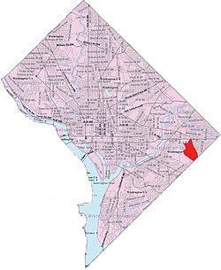
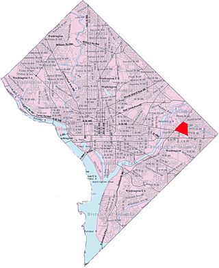
Benning is a residential neighborhood located in Ward 7 of Northeast Washington, D.C. It is bounded by East Capitol Street to the south, Minnesota Avenue to the west, and Benning Road on the north and east. It is served by the Benning Road station on the Blue and Silver Lines of the Washington Metro.

Benning Heights is a residential neighborhood located in northeast Washington, D.C. It is bounded by East Capitol Street to the south, Brooks Street NE to the north, 44th Street NE and Benning Road NE to the west, and Division Avenue NE to the east. It is served by the Benning Road Metro Rail station on the Blue Line and Silver Line of the Washington Metro.

Garfield Heights is a residential neighborhood in Southeast Bounded by Suitland Parkway SE, Alabama Avenue SE, 28th Street SE, Gainesville Street SE, Naylor Road SE, and Southern Avenue SE.Washington, D.C., bordering Prince George's County, Maryland. Garfield Heights contains both apartment units and single-family detached houses.

Civic Betterment is a small neighborhood in Southeast Washington, D.C., on the border of Prince George's County, Maryland.
Central Northeast, also sometimes called Mahaning Heights, is a small neighborhood located in Northeast Washington, D.C., with Fort Mahan Park at its center. It is bounded by Nannie Helen Burroughs Avenue to the north, Benning Road to the south, the tracks of the Washington Metro and Minnesota Ave station to the west, and 44th Street NE to the east.

River Terrace is an urban cul-de-sac neighborhood in Northeast Bounded by Anacostia Riverwalk Trail NE, East Capitol Street NE, Kenilworth Avenue NE, and Benning Road NE.Washington, D.C., on the eastern bank of the Anacostia River. River Terrace is Washington, DC's only planned unit development that has an unimpeded connection to and relationship with the Anacostia River.

Randle Highlands is a neighborhood in Southeast Washington, D.C., east of the Anacostia River.

East River Heights is a residential and mixed use neighborhood located in Ward 7 of Washington, DC. It is considered the "downtown" area of the ward and has high walkability ratings. Its borders are East Capital Street, Minnesota Ave, Benning Road up to 41st Street. It is a neighborhood of retired and working people and many children. There is quite a bit of development occurring. The houses are small but have large yards. It is centrally located. It is located between the Minnesota Avenue and Benning Road stations on the Washington Metro.
Benning Terrace is a public housing project of 274 apartments and townhouses in southeast Washington, D.C. located east of the Anacostia River in the Benning Ridge neighborhood. It is known to the natives as "Simple City."
Alexandria, Virginia is an independent city in the Commonwealth of Virginia, located along the western bank of the Potomac River. The city of approximately 151,000 is about six miles south of downtown Washington, D.C.