Pleasant Hill also borders the Fort Totten Park and Fort Totten Waste Disposal Facility on its northern end. Pleasant Hill also features direct access to the Washington Metropolitan Branch Red Line trail as well. The Pleasant Hill neighborhood is also located within very close proximity to Providence Hospital in the adjacent Michigan Park neighborhood, as well as the Armed Soldiers Retirement Home, Washington D.C. Veterans Affairs Medical Center, MedStar Washington Hospital Center, and Children's National Main Hospital in the adjacent Park View neighborhood. In terms of educational institutions and academies, the Pleasant Hill neighborhood houses the Washington Yu Ying Charter School and the Kirov Academy of Ballet of Washington D.C. Residents of the Pleasant Hill neighborhood also have convenient access to the Archbishop Carroll Catholic High School in the adjacent University Heights neighborhood.
In terms of housing, Pleasant Hill generally features medium-sized brick homes constructed between the 1930s to the 1950s and contains several apartment complex, which notably are the Hawaiian Gardens apartments, Clemont Apartments, Pleasant Hills Village Apartments, and Brookland Ridge Apartments. In terms of commerce, the Pleasant Hill contains the Heights Shopping center strip mall.
In terms of transportation, residents of the Pleasant Hill neighborhood have access to a Metrorail stations at Fort Totten, Brookland-CUA, and Georgia Avenue - Petworth Metro Stations. In addition to these three Metro Station, residents of Pleasant Hill also have access to Metrobus Service as well.
Brookland–CUA station is a Washington Metro station in Washington, D.C., on the Red Line. Service began on February 3, 1978. The station serves the Brookland neighborhood and the Catholic University of America (CUA). It is the focal point of an upcoming transit-oriented development project.
Fort Totten station is a Washington Metro station in northeastern Washington, D.C. It is one of the four major transfer points on the Metrorail system. It acts as a transfer point between the Red and Green Lines. It is the last station on the Green Line in the District of Columbia before heading into Maryland and the second to last for the Red Line. It is one of two stations with three levels, and is doubly unique in being the only multi-level transfer station built above ground and being the only such station to have island platforms on both levels, as opposed to just the lower level. The station's name comes from a Civil War-era fortification which itself was named after General Joseph Gilbert Totten, the Chief Engineer of the antebellum US Army.
Georgia Avenue–Petworth station is a Washington Metro station in Washington, D.C., on the Green Line. It is located at the border of the neighborhoods of Petworth, Sixteenth Street Heights, and Park View in Northwest.
Northeast is the northeastern quadrant of Washington, D.C., the capital of the United States. It encompasses the area located north of East Capitol Street and east of North Capitol Street.
Columbia Heights is a neighborhood in Washington, D.C., located in Northwest D.C. It has diverse demographics, the DC USA shopping mall and many restaurants, BloomBars, Meridian Hill/Malcolm X Park, Howard University, Banneker Recreation Center, and All Souls Church.
Brookland, also known as Little Rome or Little Vatican, is a neighborhood located in the Northeast (NE) quadrant of Washington, D.C. It is best known for its numerous Catholic institutions, including schools, religious communities, shrines, institutes, and other organizations built and based around the Catholic University of America.
Neighborhoods in Washington, D.C., United States are distinguished by their history, culture, architecture, demographics, and geography. The names of 131 neighborhoods are unofficially defined by the D.C. Office of Planning. Neighborhoods can be defined by the boundaries of wards, historic districts, Advisory Neighborhood Commissions, civic associations, and business improvement districts (BIDs); these boundaries will overlap. The eight wards each elect a member to the Council of the District of Columbia and are redistricted every ten years.
Woodridge is a residential neighborhood located in Ward 5 of Northeast Washington, D.C. Woodridge is contained between Eastern Avenue N.E. to the east, Taylor Street N.E. to the north, South Dakota Avenue N.E. to the west, and Bladensburg Road N.E. to the south. Its central commercial strips are Rhode Island Avenue NE and Bladensburg Road N.E. Woodridge borders the adjacent neighborhoods of Brookland, Langdon, North Michigan Park, and Fort Lincoln in Northeast Washington D.C. In addition to these neighborhoods in the District of Columbia, Woodridge also borders the city of Mount Rainier and town of Cottage City in Maryland. In terms of public transportation, residents of Woodridge have access to the Brookland-CUA and Rhode Island Avenue Metro stations.
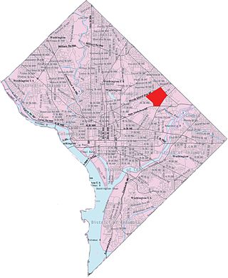
Fort Totten is a neighborhood located in Ward 5 of Northeast Washington, D.C.
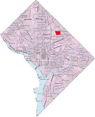
Michigan Park is a neighborhood in Ward 5 of Northeast Washington, D.C. in the Upper Northeast area element. The boundaries of Michigan Park and North Michigan Park neighborhoods are contested due to the history of racial disparity between the two, but in general Michigan Park is considered to be contained between South Dakota Avenue to the west, Eastern Avenue to the east, Galloway Street NE to the north and Taylor Street NE to the South. Both neighborhoods are in DC Neighborhood Cluster 20 along with the University Heights neighborhood. Michigan Park is home to two established Civic Associations: the North Michigan Park Civic Association which has its established boundaries that include both Michigan Park and North Michigan Park and the Queens Chapel Civic Association. The Queens Chapel association meets regularly at Union Wesley African Methodist Zion Church and its boundaries are between 16th Street NE and Webster Street NE to the north, Michigan Avenue NE to the south, and South Dakota Avenue NE to the west.
Langdon, is a neighborhood located in Ward 5 of Northeast Washington, D.C. Historical surveys of D.C. recognize Langdon as a neighborhood dating back to at least 1903. Langdon is bounded by Montana Ave. NE to the west/southwest, New York Ave. NE to the south, Bladensburg Rd. NE to the southeast, South Dakota Ave. NE to the northeast, and Rhode Island Ave. NE to the north/northwest. Langdon is adjacent to the Northeast D.C. neighborhoods of Brentwood (west), Woodridge (east), Fort Lincoln (southeast), Gateway (south), and Brookland (north).
Stronghold is the name of a neighborhood in Ward 5 of Northeast Washington D.C. Stronghold is contained between Michigan Avenue N.E. to the north, North Capitol Street N.W. to the west, and Glenwood Cemetery to both the south and east. Stronghold borders the adjacent neighborhoods of Edgewood, University Heights, and Brookland in Ward 5 of Northeast Washington D.C.
University Heights is a neighborhood adjacent to The Catholic University of America in Ward 5 of Northeast Washington, D.C. in the Upper Northeast area element. It is located east of the University and west of the Franciscan Monastery, bounded by the tracks for the Red Line of the Washington Metro to the west; 14th Street NE to the east; Taylor Street to the north; and Otis Street to the south. University Heights is in DC Neighborhood Cluster 20 along with the Michigan Park and North Michigan Park neighborhoods.
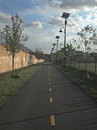
The Metropolitan Branch Trail is an American rail trail between the transit center in Silver Spring, Maryland, and Union Station in the District of Columbia. Part of the East Coast Greenway, it extends the Capital Crescent Trail where it merges with the active WMATA and CSX railroad tracks into the national capital. Planned connections include a trail from Fort Totten to the Northwest Branch Trail of the Anacostia Tributary Trail System at Hyattsville, Maryland; and an on-street connection from Union Station to the National Mall.
Avondale is an unincorporated community in Prince George's County Maryland, United States. It is contained between Eastern Avenue NE to the south, Queens Chapel Road (MD-500) to the east, and the Northwest Branch Anacostia River to the north and west.
Washington, D.C., is administratively divided into four geographical quadrants of unequal size, each delineated by their ordinal directions from the medallion located in the Crypt under the Rotunda of the Capitol. Street and number addressing, centered on the Capitol, radiates out into each of the quadrants, producing a number of intersections of identically named cross-streets in each quadrant. Originally, the District of Columbia was a near-perfect square. However, even then the Capitol was never located at the geographic center of the territory. As a result, the quadrants are of greatly varying size. Northwest is quite large, encompassing over a third of the city's geographical area, while Southwest is little more than a neighborhood and military base.
The following outline is provided as an overview of and topical guide to District of Columbia:
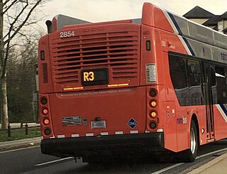
The Greenbelt–Prince George's Plaza Line, designated Route R3, was a bus route that was operated by the Washington Metropolitan Area Transit Authority between Greenbelt station and Prince George's Plaza station of the Green Line of the Washington Metro. The route provided service between the Greenbelt and Hyattsville during the weekday peak-hours. However the route was discontinued due to low ridership on March 27, 2016.
The Crosstown Line, designated Routes H2 and H4, is a daily bus route operated by the Washington Metropolitan Area Transit Authority between Brookland–CUA station and Tenleytown–AU station of the Red Line of the Washington Metro. The line operates every 24 minutes between 7AM and 9PM, and 30–40 minutes after 9PM at a combined frequency of 12 minutes during the day and, 30–40 minutes during the late nights. Trips roughly take 48 minutes to complete.
This page is based on this Wikipedia article Text is available under the CC BY-SA 4.0 license; additional terms may apply. Images, videos and audio are available under their respective licenses.