
Severn is a census-designated place (CDP) in Anne Arundel County, Maryland, United States. The population was 44,231 at the 2010 census, a 26% increase from its population of 35,076 in 2000. The zip code is 21144.

Hanley Hills is a village in St. Louis County, Missouri, United States. The population was 2,101 at the 2010 census.

Congress Heights is an island-platformed Washington Metro station in the Congress Heights neighborhood of Washington, D.C., United States. The station was opened on January 13, 2001, and is operated by the Washington Metropolitan Area Transit Authority (WMATA). Providing service for only the Green Line, the station is located at Alabama Avenue and 13th Street, lying under St. Elizabeths Hospital. Congress Heights is the last Green Line station in the District of Columbia going southeast.

Southern Avenue is an island platformed Washington Metro station in Hillcrest Heights, Maryland, United States. The station was opened on January 13, 2001, and is operated by the Washington Metropolitan Area Transit Authority (WMATA). Providing service for only the Green Line, the station is located on the southern side of Southern Avenue, putting it just outside the District of Columbia, opposite Valley Terrace. Southern Avenue is the first station in Maryland going southeast on the Green Line.

Naylor Road is an island-platformed Washington Metro station in Hillcrest Heights, Maryland, United States. The station was opened on January 13, 2001, and is operated by the Washington Metropolitan Area Transit Authority (WMATA). Providing service for only the Green Line, the station is located between Naylor Road, Branch Avenue, and Suitland Parkway.

Suitland is an island platformed Washington Metro station in Suitland, Maryland, United States. The station was opened on January 13, 2001, and is operated by the Washington Metropolitan Area Transit Authority (WMATA). Providing service for the Green Line, the station is located at Silver Hill Road and Suitland Parkway.

Branch Avenue is an island-platformed Washington Metro station in Suitland, Maryland, United States. The station was opened on January 13, 2001, and is operated by the Washington Metropolitan Area Transit Authority (WMATA). The station presently serves as the southeastern terminus for the Green Line, with the Branch Avenue rail yard lying just beyond this station. The station is located near the intersection of Auth Road and Old Soper Road.
Mudzenchoot Provincial Park is a provincial park in British Columbia, Canada, located 90km northwest of Fort St. James in the Omineca Country of that province's Central Interior. It is in a high elevation area characterized by dry meadows featuring unique vegetation types including cotton grass, erigerons, and aster type species. The park has no facilities nor road access points.

Pilot Bay Provincial Park is a provincial park in British Columbia, Canada.

Sligo Creek Trail is a paved hiker-biker trail running along Sligo Creek in the suburbs of Washington, D.C. Most of the trail passes through tree-filled parkland. The trail and surrounding park is a popular place for locals to jog, walk, bicycle, roller-skate, and take their children to the playground. Many local families enjoy picnicking at one of the 15 picnic areas along the trail.
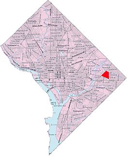
Benning Heights is a residential neighborhood located in northeast Washington, D.C. It is bounded by East Capitol Street to the south, Brooks Street NE to the north, 44th Street NE and Benning Road NE to the west, and Division Avenue NE to the east. It is served by the Benning Road Metro Rail station on the Blue Line and Silver Line of the Washington Metro.

Benning Ridge is a residential neighborhood located in Southeast Washington, D.C. It is bounded by Fort Chaplin Park to the northwest, Southern Avenue to the south, Benning Road to the east, and Ridge Road SE to the west. Benning Ridge is an unusual neighborhood for its location east of the Anacostia River: although it is surrounded by working-class and low-income African American neighborhoods, Benning Ridge is rather affluent, with a diverse population of middle- and upper-middle-class white and black residents.

Garfield Heights is a residential neighborhood in Southeast Washington, D.C., bordering Prince George's County, Maryland. Garfield Heights contains both apartment units and single-family detached houses.
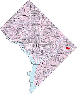
Central Northeast, also sometimes called Mahaning Heights, is a small neighborhood located in Northeast Washington, D.C. with Fort Mahan Park at its center. It is bounded by Nannie Helen Burroughs Avenue to the north, Benning Road to the south, the tracks of the Washington Metro and Minnesota Ave station to the west, and 44th Street NE to the east.

Skyland is a neighborhood in Southeast Washington, D.C. It is bounded by Good Hope Road to the northeast, Alabama Avenue to the southeast, and Fort Stanton Park to the south and west. Also see article on Anacostia.
Penn Branch is a neighborhood in Southeast Washington, D.C., east of the Anacostia River. It is bounded by Pennsylvania Avenue SE to the south; Pope Branch Park and Pope Creek to the north; Branch Avenue to the west; and Fort Davis Park to the east. ‘Penn Branch’, takes its name from its location at the intersection of two major thoroughfares, Pennsylvania and Branch Avenue.

The Cross Island Trail is a rail trail in Queen Anne's County, Maryland occupying a section of the abandoned Queen Anne's Railroad corridor that traverses the width of Kent Island. It was completed in 2001 and is part of the American Discovery Trail.

Paint Branch is a 14.0-mile-long (22.5 km) stream that flows through Montgomery County and Prince George's County, Maryland. It is a tributary of the Northeast Branch, which flows to the Anacostia River, Potomac River and the Chesapeake Bay.

The Civil War Defenses of Washington were a group of Union Army fortifications that protected the federal capital city, Washington, D.C., from invasion by the Confederate States Army during the American Civil War. The sites of some of these fortifications are within a collection of National Park Service (NPS) properties that the National Register of Historic Places identifies as the Fort Circle. The sites of other such fortifications in the area have become parts of state, county or city parks or are located on privately owned properties. A trail connecting the sites is part of the Potomac Heritage Trail.

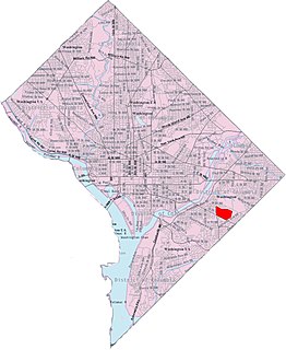
East River Heights is a residential and mixed use neighborhood located in Ward 7 of Washington, DC. It is considered the "downtown" area of the ward and has high walkability ratings. Its borders are East Capital Street, Minnesota Ave, Benning Road up to 41st Street. It is a neighborhood of retired and working people and many children. There is quite a bit of development occurring. The houses are small but have large yards. It is centrally located. It is located between the Minnesota Avenue and Benning Road stations on the Washington Metro.


