Petworth (Washington, D.C.)

Last updated

Petworth
Row Homes in Petworth - panoramio (2) (cropped).jpg
St. Gabriel Church DC 01 (cropped).JPG
Honeymoon Chicken and Petworth Cigar Lounge (cropped).jpg
03a.Petworth.GeorgiaAvenue.NW.WDC.3September2011 (6113351274) (cropped).jpg
Top: historic rowhomes (left) and St. Gabriel Church on Grant Circle (right); bottom: Upshur Street (left) and Georgia Avenue (right).
Map of Petworth Neighborhood in the District of Columbia.png
Map of Washington, with Petworth highlighted
Coordinates: 38°56′32″N77°01′32″W / 38.942161°N 77.025525°W / 38.942161; -77.025525
Quadrant Northwest
Ward 4
ANC 4C & 4D
Government
   Councilmember Janeese Lewis George
ZIP Code
20010, 20011
Area code 202

Petworth is a neighborhood of Washington, D.C., located in Northwest D.C. [1] [2] While largely residential, Petworth is home to a notable commercial corridor of shops and restaurants, primarily along Georgia Avenue and Upshur Street, as well as a portion of 14th Street. The neighborhood is accessible via the Georgia Ave–Petworth station on the Green Line of the Washington Metro.

Contents

History

Petworth Baptist Church, b. 1915 First Baptist Church - Randolph & New Hampshire NW DC (cropped).JPG
Petworth Baptist Church, b. 1915
Roosevelt High School, b. 1932 Theodore Roosevelt High School, 13th St. in upper NW, Washington, D.C LCCN2010641811 (cropped).tif
Roosevelt High School, b. 1932

Petworth was the name of the 205-acre country estate of John Tayloe III, of Mount Airy and The Octagon House, likely named for the ancient town of Petworth in West Sussex, England. Here he kept horses for the races at the Washington Jockey Club, a club he founded with Charles Carnan Ridgely of Hampton.

The estate, located at the northeast corner of 7th Street Pike (later known as Brightwood Avenue, now Georgia Avenue) and Rock Creek Church Road, was bequeathed to his son Benjamin Ogle Tayloe. In 1887, it was sold by Tayloe's heirs to developers for $107,000. [3] [4] In 1889, developers registered “Petworth” with the District surveyor as a 387-acre plat of subdivision containing the former Tayloe estate and the Marshal Brown estate. [5] In 1893, additional real estate deals formed "West Petworth," from land west of Brightwood Avenue, including the Ruppert Farm, which was sold for $142,680, the 20-acre Burnaby tract, and a 14-acre property known as Poor Tom’s Last Shaft. [6] In 1900, Henry J. Ruppert sold an additional 31.7 acres west of Brightwood and Iowa Avenues and south of Utica Street (now Allison Street) [7] to the District for a proposed municipal hospital. [8]

In the early 1900s, the expansion of a streetcar line along Georgia Avenue to the border of Silver Spring, Maryland, made Petworth more accessible.

Many of the thousands of similar brick row houses in the neighborhood were constructed by Morris Cafritz and by D.J. Dunigan Company in the 1920s–1930s. Dunigan donated the land that became the site for St. Gabriel's Church and School next to Grant Circle.[ citation needed ]

Demographics

YearTotal ANC-4C population [9]  % Children % Black % White % Hispanic % Asian/P.I.Average family incomeMedian home sales price
199019,87519%88%6%6%1%$77,679$166,000
200019,51923%72%6%20%1%$85,209$177,000
200519,54017%63%14%20%1%$92,009$491,000
201020,33019%57%15%26%2%Not Avail.$460,000

Education

Petworth Neighborhood Library Petworth Branch Library (cropped).jpg
Petworth Neighborhood Library
MacFarland Middle School MacFarland Middle School DC (cropped).jpg
MacFarland Middle School

Petworth Neighborhood Library opened in 1939 at the corner of Georgia Ave. NW, Kansas Ave. NW, and Upshur St. NW. [10] In addition to providing access to DC Public Library general circulation items, the library’s collection includes a Spanish Language collection, job and employment literature, and Adult Basic Education materials.

Petworth is served by District of Columbia Public Schools (DCPS). Roosevelt Senior High School enrolls students in ninth through 12th grade. [11] Truesdell Education Campus enrolls in grades pre-kindergarten through eighth grade. [12] Powell enrolls students in pre-kindergarten through fifth grade. [13]

Charter schools

Economy

Shops on Upshur Street Lulabelle's Sweet Shop (cropped).jpg
Shops on Upshur Street

In the 2000s, Petworth experienced growth in its commercial corridor. [19] [20] There are restaurants and bars in the neighborhood [21] though several restaurants on Upshur Street closed in late 2018. [22]

Local events

Landmarks

Petworth Methodist Church, b. 1916 Petworth UMC DC.JPG
Petworth Methodist Church, b. 1916
Entrance to Rock Creek Cemetery St. Paul's Rock Creek Church Yard Entrance Gate.jpg
Entrance to Rock Creek Cemetery
Israel Metropolitan Christian Methodist Episcopal Church Israel CME DC.JPG
Israel Metropolitan Christian Methodist Episcopal Church

Public art

Notable residents

The historic site of Billy Simpson's House of Seafood and Steaks Billy Simpson DC 3rd from left.JPG
The historic site of Billy Simpson's House of Seafood and Steaks

Related Research Articles

<span class="mw-page-title-main">Adams Morgan</span> Neighborhood of Washington, D.C.

Adams Morgan, commonly abbreviated as AdMo, is a neighborhood in Washington, D.C., located in Northwest D.C. Adams Morgan is noted as a historic hub for counterculture and as an arts district. It is also known for its popular entertainment district and culinary scene, centered on both 18th Street and Columbia Road.

<span class="mw-page-title-main">Georgia Avenue–Petworth station</span> Washington Metro station

Georgia Avenue–Petworth station is a Washington Metro station in Washington, D.C., on the Green Line. It is located at the border of the neighborhoods of Petworth, Sixteenth Street Heights, and Park View in Northwest.

<span class="mw-page-title-main">Northwest (Washington, D.C.)</span> Quadrant in the United States

Northwest is the northwestern quadrant of Washington, D.C., the capital of the United States, and is located north of the National Mall and west of North Capitol Street. It is the largest of the four quadrants of the city, and it includes the central business district, the Federal Triangle, and the museums along the northern side of the National Mall, as well as many of the District's historic neighborhoods.

<span class="mw-page-title-main">Shepherd Park</span>

Shepherd Park is a neighborhood in the northwest quadrant of Washington, D.C. In the years following World War II, restrictive covenants which had prevented Jews and African Americans from purchasing homes in the neighborhood were no longer enforced, and the neighborhood became largely Jewish and African American. Over the past 40 years, the Jewish population of the neighborhood has declined but the neighborhood has continued to support a thriving upper and middle class African American community. The Shepherd Park Citizens Association and Neighbors Inc. led efforts to stem white flight from the neighborhood in the 1960s and 1970s, and it has remained a continuously integrated neighborhood, with very active and inclusive civic groups.

<span class="mw-page-title-main">Outdoor sculpture in Washington, D.C.</span>

There are many outdoor sculptures in Washington, D.C. In addition to the capital's most famous monuments and memorials, many figures recognized as national heroes have been posthumously awarded with his or her own statue in a park or public square. Some figures appear on several statues: Abraham Lincoln, for example, has at least three likenesses, including those at the Lincoln Memorial, in Lincoln Park, and the old Superior Court of the District of Columbia. A number of international figures, such as Mohandas Gandhi, have also been immortalized with statues. The Statue of Freedom is a 19½-foot tall allegorical statue that rests atop the United States Capitol dome.

<span class="mw-page-title-main">Takoma (Washington, D.C.)</span> Neighborhood of Washington, D.C.

Takoma, Washington, D.C., is a neighborhood in Washington, D.C. It is located in Advisory Neighborhood Commission 4B, in the District's Fourth Ward, within the northwest quadrant. It borders the city of Takoma Park, Maryland.

<span class="mw-page-title-main">Brightwood (Washington, D.C.)</span> Place in the United States

Brightwood is a neighborhood in the northwestern quadrant of Washington, D.C. Brightwood is part of Ward 4.

<span class="mw-page-title-main">Fort Totten (Washington, D.C.)</span> Place in the United States

Fort Totten is a neighborhood located in Ward 5 of Northeast Washington, D.C.

<span class="mw-page-title-main">Georgia Avenue</span> Major north-south artery in NW Washington, DC, and Montgomery County, Maryland, US

Georgia Avenue is a major north-south artery in Northwest Washington, D.C., and Montgomery County, Maryland. Within the District of Columbia and a short distance in Silver Spring, Maryland, Georgia Avenue is also U.S. Route 29. Howard University is located on Georgia Avenue.

<span class="mw-page-title-main">Park View (Washington, D.C.)</span> Neighborhood of Washington, D.C.

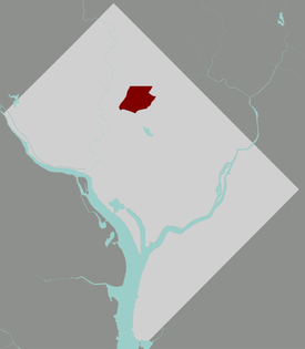
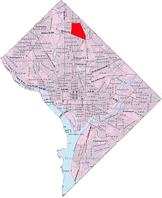
Park View is a neighborhood in Washington, D.C., located in Northwest D.C. The neighborhood is primarily residential with its main commercial corridor of shops and restauarants located along Georgia Avenue.

<span class="mw-page-title-main">New Hampshire Avenue</span> Diagonal street in Washington, D.C.

New Hampshire Avenue is a diagonal street in Washington, D.C., beginning at the Kennedy Center and extending northeast for about 5 miles (8 km) and then continuing into Maryland where it is designated Maryland Route 650. New Hampshire Avenue, however, is not contiguous. It stops at 15th and W Streets NW and resumes again on the other side of Columbia Heights at Park Road NW, a few blocks from Georgia Avenue. New Hampshire Avenue passes through several Washington neighborhoods including Foggy Bottom, Dupont Circle, Petworth and Lamond-Riggs.

Sherman Circle is an urban park and traffic circle in the Northwest Washington, D.C. neighborhood of Petworth at the intersection of Illinois Avenue, Kansas Avenue, 7th Street, and Crittenden Street NW. The circle is named in honor of Civil War general William Tecumseh Sherman. Administered by the National Park Service's Rock Creek Park unit, Sherman Circle together with four surrounding triangular parks covers 3.44 acres (1.39 ha) and is considered by the National Park Service a "cultural landscape."

<span class="mw-page-title-main">Grant Circle</span>

Grant Circle is a traffic circle in the Petworth neighborhood of Northwest Washington, D.C. New Hampshire and Illinois Avenues NW, Varnum Street NW, and 5th Street NW all intersect at this circle. The park within the circle and the adjoining triangles is owned and administered by the National Park Service through its Rock Creek Park unit. The circle and the buildings flanking it were listed on the National Register of Historic Places in 2015.

<span class="mw-page-title-main">Manor Park (Washington, D.C.)</span>

Manor Park is a neighborhood in Ward 4 of northwest Washington, D.C.

<span class="mw-page-title-main">Pleasant Hill (Washington, D.C.)</span> Place in the United States

Pleasant Hill is a neighborhood located in Ward 5 of Northeast Washington, D.C. Pleasant Hill is contained between Allison Street NE and Bates Road NE to the north, Taylor Street NE to the south, the Washington Metropolitan Area Red Line tracks to the east, and North Capitol Street NW to the west. Pleasant Hill borders the adjacent neighborhoods of Fort Totten (north), North Michigan Park (northeast), Michigan Park (east), University Heights (south), Petworth (west), Brightwood Park (northwest), and Park View (southwest). It is adjacent to the Catholic University of America and even houses its athletic facilities. Pleasant Hill houses the Catholic University of America's soccer and football fields as well as its Raymond A. DuFour Athletic Center.

<span class="mw-page-title-main">Brightwood Park</span> Place in the United States

Brightwood Park is a small neighborhood in Northwest Washington, D.C. in the United States. The neighborhood is bounded by Georgia Avenue NW to the west, Missouri Avenue NW to the northeast and Kennedy Street NW to the south. More recently, areas that are technically part of the northern extremity of the Petworth neighborhood have been increasingly referred to as Brightwood Park. Often these informal boundaries extend south to Emerson Street NW, and east to New Hampshire Avenue NW. Another definition places Hamilton Street NW as Brightwood Park's southern boundary. Yet another definition places Brightwood Park's southern boundary as Ingraham Street NW. The most expansive definition state Brightwood Park's borders as Missouri Avenue to the north, North Capitol Street on the east, Emerson Street to the south and Georgia Avenue on the west. It is located in Ward 4.

<span class="mw-page-title-main">Sixteenth Street Heights</span>

Sixteenth Street Heights is a large neighborhood of rowhouses, duplexes, and American Craftsman and American Foursquare detached houses in Northwest Washington, D.C.

<span class="mw-page-title-main">Metropolitan Railroad</span>

The Metropolitan Railroad was the second streetcar company to operate in Washington, D.C., the capital city of the United States. It was incorporated and started operations in 1864, running from the Capitol to the War Department and along H Street NW in downtown. It added lines on 9th Street NW, on 4th Street SW/SE, along Connecticut Avenue to Dupont Circle, to Georgetown, to Mount Pleasant and north along Georgia Avenue. In the late 19th century, it was purchased by the Washington Traction and Electric Company and on February 4, 1902, became a part of the Washington Railway and Electric Company.

Fort Stevens Ridge is a neighborhood in Northwest Washington, D.C. built during the 1920s. The neighborhood comprises about 50 acres (0.20 km2) and is very roughly bounded by Peabody Street, Fifth Street, Underwood Street, and Ninth Street. As of the 2010 census, the neighborhood had 2,597 residents. It was named for nearby Fort Stevens, a Civil War-era fort used to defend the nation's capital from invasion by Confederate soldiers.

<span class="mw-page-title-main">Roosevelt High School (Washington, D.C.)</span> Public high school in Washington D.C., United States

Theodore Roosevelt High School is a public high school operated by the District of Columbia Public Schools in the Petworth neighborhood of Ward 4 neighborhood of Northwest Washington, D.C. Roosevelt enrolls 698 students (2017–2018) in ninth through 12th grade. Additionally, the high school is also home to Roosevelt S.T.A.Y. program, an alternative academic and career/technical program that leads to a high school diploma or vocational certificate.

References

  1. "Google Maps search for Petworth". Google Maps.
  2. Lasky, Julie (May 15, 2015). "Petworth, Washington, D.C.: A Place of Porches" . The New York Times .
  3. "Another purchase of suburban property". The Washington Post . March 4, 1887. ProQuest   138151785.
  4. "Bits of Local News". The Washington Post . January 6, 1888. ProQuest   138253999.
  5. "The Plat of "Petworth" Filed". The Washington Post . January 17, 1889. ProQuest   138395748.
  6. "Sale of West Petworth". The Washington Post . July 27, 1893. ProQuest   138952276.
  7. "New Street Names". The Washington Post . August 2, 1905. ProQuest   144591749.
  8. "Hospital Site Chosen". The Washington Post . November 17, 1900. ProQuest   144159308.
  9. "Neighborhood Info DC" . Retrieved September 26, 2012.
  10. "Petworth Library History". District of Columbia Public Library.
  11. 1 2 "Roosevelt High School Project". DC Department of General Services.
  12. "Truesdell Education Campus Profile". District of Columbia Public Schools.
  13. "Powell Elementary School Profile". District of Columbia Public Schools.
  14. "Breakthrough Montessori".
  15. "Bridges Public Charter School".
  16. "Center City Public Charter School – Petworth Campus".
  17. "E.L. Haynes Public Charter School".
  18. "Washington Latin Public Charter School".
  19. Severson, Kim (January 14, 2009). "Chefs Settle Down in 'the Real D.C.'". The New York Times .
  20. STEINHAUER, JENNIFER (October 20, 2014). "Washington Has More on Its Plate". The New York Times .
  21. Hahn, Fritz; Krystal, Becky (February 9, 2017). "A guide to eating and drinking in Petworth". The Washington Post .
  22. Kurzius, Rachel (December 6, 2018). "With Recent Closures, Is Upshur Street In Trouble?". DCist . Archived from the original on December 7, 2018.
  23. "Upshur Street Art and Craft Fair".
  24. "Petworth Community Market".
  25. "Petworth Jazz Project".
  26. "Celebrate Petworth". Celebrate Petworth.
  27. 1 2 3 4 5 6 7 "DC Inventory of Historic Sites". DC Office of Planning. November 21, 2014.
  28. "Ten Facts You May Not Know About Petworth". DCist. January 31, 2019. Archived from the original on January 31, 2019.
  29. "Here I Stand: The Spirit of Paul Robeson". National Capital Planning Commission.
  30. "Art in Transit: Georgia Ave-Petworth".
  31. "Petworth's Chuck Brown Mural to Be Torn Down for Apartments". Curbed . July 31, 2015.
  32. "Tear down of the Chuck Brown mural on Sweet Mango in Petworth". DC Public Library, The People's Archive, Chip Py Go-GO Collection. January 1, 2020.
  33. "An abstract artwork designed to complement a neighborhood's energy". Petworth News. August 11, 2015.
  34. "New mural on Kansas Ave celebrates the mysteries of nature". Petworth News. July 10, 2016.

38°57′07″N77°01′11″W / 38.9519°N 77.0196°W / 38.9519; -77.0196