Edgewood (Washington, D.C.)

Last updated
Edgewood
Map edgewood.jpg
Edgewood within the District of Columbia
Coordinates: 38°55′21″N77°00′02″W / 38.9226°N 77.0005°W / 38.9226; -77.0005
Country United States
District Washington, D.C.
WardWard 5
Government
  Councilmember Kenyan McDuffie
Edgewood Estate, 1887 Edgewood Estate, 1887.jpg
Edgewood Estate, 1887

Edgewood is a neighborhood located in Ward 5 of Northeast Washington, D.C. Edgewood is bounded by Michigan Avenue NE to the north, Rhode Island Avenue NE to the south, North Capitol Street to the west, and the Washington Metro's Red Line to the east. [1] The eastern boundary originates with the establishment of the former Metropolitan Branch of the Baltimore and Ohio Railroad in 1873, [2] creating the physical barrier which today separates Edgewood from Brookland to the east.

Contents

History

Intersection of Franklin St. and 5th St. NE, in Edgewood, July 2021. Edgewood Washington DC 2021.jpg
Intersection of Franklin St. and 5th St. NE, in Edgewood, July 2021.

What is today the neighborhood of Edgewood derives its name from the “Edgewood” estate of Salmon P. Chase. Appointed by President Abraham Lincoln, Chase served as U.S. Treasury Secretary from 1861 to 1864. During this period, Chase purchased part of a 30-acre (120,000 m2) plot called Metropolis View as well as another 20 acres (81,000 m2) of nearby land.* Here, he built an estate at what is now 4th and Edgewood Streets NE and named the newly expanded property Edgewood, with building completed in 1865. [3]

Following his time at the Department of Treasury, Lincoln also appointed him to serve as Chief Justice of the United States, where he presided until his death in 1873. Upon his passing, Chase's will left his estate equally to his two daughters – Katherine Chase Sprague and Janet Ralston “Nettie” Chase Hoyt. Nettie, happily married to William Sprague Hoyt since 1871 and financially well-off at the time, had no interest in the property. She later sold her share to her sister for $16,875 (at six percent interest), making Kate the estate's sole owner. [4]

The combination of her father's death, the Panic of 1873, and her divorce from William Sprague in 1882 put Kate into dire financial straits and unable to maintain Edgewood. By the 1890s, in an effort to make the estate a going concern, she grew vegetables and raised chickens on the grounds – even delivering eggs into Washington in her own carriage. This approach proved unsuccessful, as the estate required near constant upkeep. Washington Loan and Trust, which held the mortgage on Edgewood, attempted to auction the estate's effects in January 1895 to recover outstanding amounts due on the loan. The company did succeed in partially emptying the estate's contents before Kate could secure a stay; however, within six months, the bank foreclosed on the estate – giving Kate until February 1, 1896, to bring her account current. [4]

Seeking financial assistance, Kate left Washington to enlist help from old friends and past admirers of her father. She first traveled to her home state of Ohio, and, when that proved futile, she went to New York. There, she sought to secure funds for Edgewood under the guise of preserving it as “a historic landmark in appreciation of the value of her father’s public service.” [5] She endeavored to persuaded Henry Villard – a powerful journalist and financier from the Chases’ past – to arrange a group of donors to support the estate. Villard obliged because he remembered Kate fondly for her generosity to him early in his career. In addition to Villard, backers included notable individuals like J. P. Morgan (of today's JPMorgan Chase, for whom Kate's father is a partial, historical namesake), Collis Potter Huntington, and Levi P. Morton. The group established a trust fund in the amount of $80,000, which was sufficient to bring Edgewood out of foreclosure and to provide Kate a small stipend for a few years until the estate could be sold for a profit. [6]

Hardship and poverty eventually got the better of Kate before she could realize these plans for the dilapidated estate. On the morning of July 31, 1899, she died at age 58 of what was then called Bright's disease. Kate's daughters Ethel and Portia subsequently shuttered Edgewood, and went back to their respective homes in Brooklyn and Narragansett Pier. [4]

In 1900, having outgrown its original 10th and G location, St. Vincent's Orphan Asylum for Girls purchased Edgewood and moved operations to the vacant estate. As a Catholic organization, this was a logical choice given the property's considerable acreage and its proximity to the Catholic University of America (Catholic University). The orphanage's final decades saw a precipitous decline in the number of girls served, with only girls between the ages of six and twelve being accepted by 1959. Interestingly, while St. Vincent's possible population was limited by age, the orphanage was notable for being racially integrated – though there were few African-American girls. In 1968, the orphanage ceased operations, with Edgewood being its final home. [7]

The mansion was eventually razed in the proceeding years. Today, the vast majority of the land that was occupied by the estate's grounds became what is now Edgewood Commons (formerly known as Edgewood Terrace) and Rhode Island Avenue Shopping Center. The former is a large complex of mixed-income and senior citizen public housing, opened in 1972. [8]

Catholic institutions

Holy Redeemer College Holy Redeemer College DC 02.JPG
Holy Redeemer College
A mausoleum in Saint Mary's Catholic Cemetery in Edgewood Mausoleum in St Mary's Catholic Cemetery, Edgewood, Washington DC.jpg
A mausoleum in Saint Mary's Catholic Cemetery in Edgewood

Edgewood, together with its surrounding neighborhoods, has been at times referred to as "Little Rome" because of the many Catholic organizations and institutions clustered around Catholic University. [9] The university itself does not lie within Edgewood's borders, but since the Catholic Church purchased the Middletown estate, adjacent to Edgewood, in 1887, many Catholic groups have established themselves there and in the neighboring communities of Brookland and Michigan Park. Ordered by year of establishment, major Catholic organizations that are physically located in Edgewood include:

Landmarks

Businesses

"In November 2011, D.C. based real estate developer Abdo broke ground on a large mixed-use development spread over a previously underutilized 8.9-acre plot. [11] The project, known as Monroe Street Market, was fully completed in 2014. Despite the word "BROOKLAND" prominently painted on the main building, the entire complex lies within Edgewood. [1] [12] This area includes 27 artists' studios on an "Arts Walk" and commercial businesses & restaurants. While there are future projects slated, at least part of the community believes the area is being overly developed, which has led to a few court battles with developers. [13]

Transportation

Edgewood does not have a dedicated Metro station within its borders. Given that the neighborhood's eastern boundary is the Washington Metro's Red Line, Edgewood is served by the Brookland–CUA station and the Rhode Island Avenue–Brentwood station. The latter was one of Metro's original six stations opened on March 29, 1976.

The Metropolitan Branch Trail travels through Edgewood on its way from the transit center in Silver Spring, Maryland to Washington Union Station in the NoMa neighborhood. There are three entry/exit points within Edgewood at the following locations (north to south):

Related Research Articles

<span class="mw-page-title-main">Rhode Island Avenue station</span> Washington Metro station

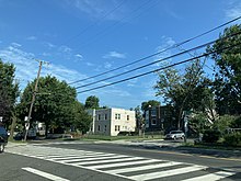
Rhode Island Avenue station is a Washington Metro station in Washington, D.C., on the Red Line. The station is located in the Brentwood neighborhood of Northeast, on an elevated platform crossing Rhode Island Avenue NE

<span class="mw-page-title-main">Brookland–CUA station</span> Washington Metro station

Brookland–CUA station is a Washington Metro station in Washington, D.C., on the Red Line. Service began on February 3, 1978. The station serves the Brookland neighborhood and the Catholic University of America (CUA). It is the focal point of an upcoming transit-oriented development project.

<span class="mw-page-title-main">Northeast (Washington, D.C.)</span> Quadrant in the United States

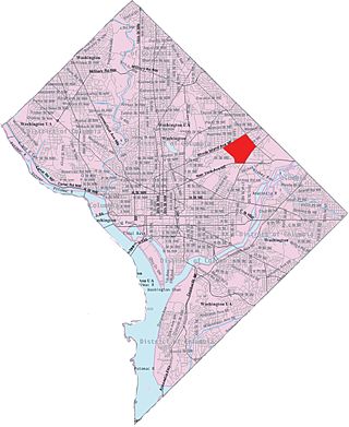
Northeast is the northeastern quadrant of Washington, D.C., the capital of the United States. It encompasses the area located north of East Capitol Street and east of North Capitol Street.

<span class="mw-page-title-main">Friendship Heights</span> Neighborhood in Ward 3, United States

Friendship Heights is an urban commercial and residential neighborhood in northwest Washington, D.C., and southern Montgomery County, Maryland. Though its borders are not clearly defined, Friendship Heights consists roughly of the neighborhoods and commercial areas around Wisconsin Avenue north of Fessenden Street NW and Tenleytown to Somerset Terrace and Willard Avenue in Maryland, and from River Road in the west to Reno Road and 41st Street in the east. Within Maryland west of Wisconsin Avenue is the Village of Friendship Heights, technically a special taxation district.

<span class="mw-page-title-main">Brookland (Washington, D.C.)</span> Place in the United States

Brookland, also known as Little Rome or Little Vatican, is a neighborhood located in the Northeast (NE) quadrant of Washington, D.C. It is best known for its numerous Catholic institutions, including schools, religious communities, shrines, institutes, and other organizations built and based around the Catholic University of America.

<span class="mw-page-title-main">Eckington (Washington, D.C.)</span> Place in the United States

Eckington is a neighborhood in Northeast Washington, D.C., located south of the Prospect Hill and Glenwood Cemeteries. Eckington is less than one mile (1.6 km) southeast of Howard University and exactly one mile north of the United States Capitol. Eckington is also the home of the District of Columbia office of Sirius XM Radio.

<span class="mw-page-title-main">William Sprague IV</span> American politician

William Sprague IV Governor of Rhode Island when he answered office from 1860 to 1863, and U.S. Senator from 1863 to 1875. He participated in the First Battle of Bull Run during the American Civil War while he was a sitting Governor.

<span class="mw-page-title-main">Woodridge (Washington, D.C.)</span> Place in the United States

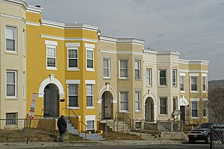
Woodridge is a residential neighborhood located in Ward 5 of Northeast Washington, D.C. Woodridge is contained between Eastern Avenue N.E. to the east, Taylor Street N.E. to the north, South Dakota Avenue N.E. to the west, and Bladensburg Road N.E. to the south. Its central commercial strips are Rhode Island Avenue NE and Bladensburg Road N.E. Woodridge borders the adjacent neighborhoods of Brookland, Langdon, North Michigan Park, and Fort Lincoln in Northeast Washington D.C. In addition to these neighborhoods in the District of Columbia, Woodridge borders the city of Mount Rainier and town of Cottage City in Maryland. In terms of public transportation, residents of Woodridge have access to the Brookland-CUA and Rhode Island Avenue Metro stations.

<span class="mw-page-title-main">Rhode Island Avenue</span>

Rhode Island Avenue is a diagonal avenue in the Northwest and Northeast quadrants of Washington, D.C., and the capital's inner suburbs in Prince George's County, Maryland. Paralleling New York Avenue, Rhode Island Avenue was one of the original streets in Pierre L'Enfant's plan for the capital. It became a major commuter route, carrying U.S. Route 1 traffic into the city from Prince George's County.

<span class="mw-page-title-main">Fort Totten (Washington, D.C.)</span> Place in the United States

Fort Totten is a neighborhood located in Ward 5 of Northeast Washington, D.C.

<span class="mw-page-title-main">Kate Chase</span>

Katherine Jane "Kate" Chase Sprague was a Washington society hostess during the American Civil War. During the war, she married Rhode Island Governor William Sprague.

<span class="mw-page-title-main">Michigan Park (Washington, D.C.)</span> Place in the United States

Michigan Park is a neighborhood in Ward 5 of Northeast Washington, D.C. in the Upper Northeast area element. The boundaries of Michigan Park and North Michigan Park neighborhoods are contested due to the history of racial disparity between the two, but in general Michigan Park is considered to be contained between South Dakota Avenue to the west, Eastern Avenue to the east, Galloway Street NE to the north and Taylor Street NE to the South. Both neighborhoods are in DC Neighborhood Cluster 20 along with the University Heights neighborhood. Michigan Park is home to two established Civic Associations: the North Michigan Park Civic Association which has its established boundaries that include both Michigan Park and North Michigan Park and the Queens Chapel Civic Association. The Queens Chapel association meets regularly at Union Wesley African Methodist Zion Church and its boundaries are between 16th Street NE and Webster Street NE to the north, Michigan Avenue NE to the south, and South Dakota Avenue NE to the west.

<span class="mw-page-title-main">Langdon (Washington, D.C.)</span> Place in the United States

Langdon, is a neighborhood located in Ward 5 of Northeast Washington, D.C. Historical surveys of D.C. recognize Langdon as a neighborhood dating back to at least 1903. Langdon is bounded by Montana Ave. NE to the west/southwest, New York Ave. NE to the south, Bladensburg Rd. NE to the southeast, South Dakota Ave. NE to the northeast, and Rhode Island Ave. NE to the north/northwest. Langdon is adjacent to the Northeast D.C. neighborhoods of Brentwood (west), Woodridge (east), Fort Lincoln (southeast), Gateway (south), and Brookland (north).

<span class="mw-page-title-main">Stronghold (Washington, D.C.)</span> Place in the United States

Stronghold is the name of a neighborhood in Ward 5 of Northeast Washington D.C. Stronghold is contained between Michigan Avenue N.E. to the north, North Capitol Street N.W. to the west, and Glenwood Cemetery to both the south and east. Stronghold borders the adjacent neighborhoods of Edgewood, University Heights, and Brookland in Ward 5 of Northeast Washington D.C.

<span class="mw-page-title-main">Pleasant Hill (Washington, D.C.)</span> Place in the United States

Pleasant Hill is a neighborhood located in Ward 5 of Northeast Washington, D.C. Pleasant Hill is contained between Allison Street NE and Bates Road NE to the north, Taylor Street NE to the south, the Washington Metropolitan Area Red Line tracks to the east, and North Capitol Street NW to the west. Pleasant Hill borders the adjacent neighborhoods of Fort Totten (north), North Michigan Park (northeast), Michigan Park (east), University Heights (south), Petworth (west), Brightwood Park (northwest), and Park View (southwest). It is adjacent to the Catholic University of America and even houses its athletic facilities. Pleasant Hill houses the Catholic University of America's soccer and football fields as well as its Raymond A. DuFour Athletic Center.

<span class="mw-page-title-main">Metropolitan Branch Trail</span>

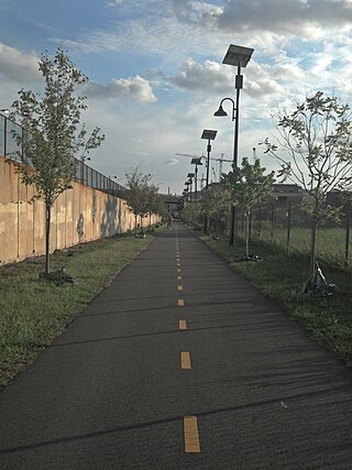
The Metropolitan Branch Trail is an American rail trail between the transit center in Silver Spring, Maryland, and Union Station in the District of Columbia. Part of the East Coast Greenway, it extends the Capital Crescent Trail where it merges with the active WMATA and CSX railroad tracks into the national capital. Planned connections include a trail from Fort Totten to the Northwest Branch Trail of the Anacostia Tributary Trail System at Hyattsville, Maryland; and an on-street connection from Union Station to the National Mall.

<span class="mw-page-title-main">Greenbelt–Prince George's Plaza Line</span> WMATA bus route R3

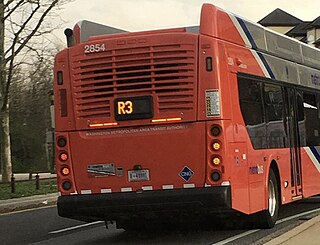
The Greenbelt–Prince George's Plaza Line, designated Route R3, was a bus route that was operated by the Washington Metropolitan Area Transit Authority between Greenbelt station and Prince George's Plaza station of the Green Line of the Washington Metro. The route provided service between the Greenbelt and Hyattsville during the weekday peak-hours. However the route was discontinued due to low ridership on March 27, 2016.

<span class="mw-page-title-main">Queens Chapel Road Line</span>

The Queens Chapel Road Line, designated Route R4, is a daily bus route operated by the Washington Metropolitan Area Transit Authority between the Highview Apartment Complex in Hyattsville, Maryland and Brookland–CUA station of the Red Line of the Washington Metro. The line operates every 20–35 minutes during peak hours, 70 minutes during midday service and 65–70 minutes on the weekends. R4 trips are roughly 30 minutes.

<span class="mw-page-title-main">Crosstown Line (Washington, D.C.)</span>

The Crosstown Line, designated Routes H2 and H4, is a daily bus route operated by the Washington Metropolitan Area Transit Authority between Brookland–CUA station and Tenleytown–AU station of the Red Line of the Washington Metro. The line operates every 24 minutes between 7AM and 9PM, and 30–40 minutes after 9PM at a combined frequency of 12 minutes during the day and, 30–40 minutes during the late nights. Trips roughly take 48 minutes to complete.

References

  1. 1 2 https://goo.gl/maps/HfNB5TmHQsv Edgewood Map
  2. "The Metropolitan Railroad" (PDF). The Evening Star. Washington, D.C. April 30, 1873. p. 4.
  3. https://planning.dc.gov/sites/default/files/dc/sites/op/page_content/attachments/Ward%205%20Heritage%20Guide%20FINAL.pdf [ bare URL PDF ]
  4. 1 2 3 Kate Chase and William Sprague: Politics and Gender in a Civil War Marriage
  5. American Queen: The Rise and Fall of Kate Chase Sprague – Civil War “Belle”…
  6. American Queen: The Rise and Fall of Kate Chase Sprague–Civil War "Belle of the North" and Gilded Age Woman of Scandal
  7. "Finding Aids".
  8. "Edgewood Terrace Open in Northeast". The Washington Post. October 21, 1972. p. D2.
  9. "Debates Over Development In D.C.'s "Little Rome"". The Kojo Nnamdi Show. October 13, 2016. Retrieved 5 January 2017.
  10. "ALBUS CAVUS OPEN WALLS".
  11. Paul, Shilpi (November 9, 2011). "Brookland's Monroe Street Market Breaks Ground". Urban Turf. Retrieved 5 January 2017.
  12. http://www.popville.com/2016/07/edgewood-getting-into-the-branding-game/ Popville (07/08/16)
  13. Alpert, David (June 2, 2016). "A court ruling on a Brookland development could imperil future housing near Metro stations". Greater Greater Washington. Retrieved 5 January 2017.