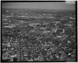
Fort Totten is a Washington Metro station in northeastern Washington, D.C. It acts as a transfer point between the Green, Yellow and Red Lines. It is the last station on the Green and Yellow lines in the District of Columbia before heading into Maryland. It is one of two stations with three levels, and is doubly unique in being the only multi-level transfer station built above ground and being the only such station to have island platforms on both levels, as opposed to just the lower level. The station's name comes from a Civil War-era fortification which itself was named after General Joseph Gilbert Totten, the Chief Engineer of the antebellum US Army.

Northwest is the northwestern quadrant of Washington, D.C., the capital of the United States, and is located north of the National Mall and west of North Capitol Street. It is the largest of the four quadrants of the city, and it includes the central business district, the Federal Triangle, and the museums along the northern side of the National Mall, as well as many of the District's historic neighborhoods.
Northeast is the northeastern quadrant of Washington, D.C., the capital of the United States. It encompasses the area located north of East Capitol Street and east of North Capitol Street.

Brookland, also known as Little Rome, is a neighborhood located in the Northeast (NE) quadrant of Washington, D.C. It is best known for its numerous Catholic institutions, including schools, religious communities, shrines, institutes, and other organizations built and based around the Catholic University of America.

Neighborhoods in Washington, D.C., are distinguished by their history, culture, architecture, demographics, and geography. The names of 131 neighborhoods are unofficially defined by the D.C. Office of Planning. Neighborhoods can be defined by the boundaries of wards, historic districts, Advisory Neighborhood Commissions, civic associations, and business improvement districts (BIDs); these boundaries will overlap. The eight wards each elect a member to the Council of the District of Columbia and are redistricted every ten years.

Woodridge is a residential neighborhood located in Ward 5 of Northeast Washington, D.C. Woodridge is contained between Eastern Avenue N.E. to the east, Taylor Street N.E. to the north, South Dakota Avenue N.E. to the west, and Bladensburg Road N.E. to the south. Its central commercial strips are Rhode Island Avenue NE and Bladensburg Road N.E. Woodridge borders the adjacent neighborhoods of Brookland, Langdon, North Michigan Park, and Fort Lincoln in Northeast Washington D.C. In addition to these neighborhoods in the District of Columbia, Woodridge also borders the city of Mount Rainier and town of Cottage City in Maryland. In terms of public transportation, residents of Woodridge have access to the Brookland-CUA and Rhode Island Avenue Metro stations.

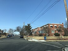
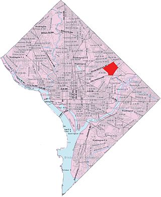
Fort Totten is a neighborhood located in Ward 5 of Northeast Washington, D.C.

Queens Chapel is a mostly residential neighborhood with commercial elements located in Ward 5 of Northeast Washington, D.C.

North Michigan Park is a neighborhood located in Ward 5 of Northeast Washington, D.C. North Michigan Park is contained between Eastern Avenue N.E. to the east, Gallatin Street N.E. to the north, Michigan Avenue N.E. to the south, and South Dakota Avenue N.E. to the west. North Michigan Park borders the neighborhoods of Michigan Park, Queens Chapel, and Woodridge, which also are located in Ward 5 of Northeast Washington D.C. In addition to these neighborhoods in Ward 5 of Northeast Washington D.C., North Michigan Park also borders the adjacent neighborhoods of Avondale and Chillum, which are both located in Prince George's County, Maryland. North Michigan Park neighborhood is often confused with the North Michigan Park Civic Association which has boundaries that include both North Michigan Park and Michigan Park. North Michigan Park and Michigan Park neighborhoods have been historically designated as separate neighborhoods due to the fact that they were segregated by race. North Michigan Park was the less desirable neighborhood where African-Americans lived while Michigan Park was a much more desirable neighborhood where the neighborhood where their white counterparts lived. Both neighborhoods are separated from each other by South Dakota Avenue N.E. The Washington Metropolitan Area Green Line train tracks pass through the North Michigan Park neighborhood, notably, through a tunnel when traveling between the West Hyattsville and Fort Totten Metro Stations. The Washington Metropolitan Area Green Line train tracks initially are above ground when traveling between the West Hyattsville Metro Station and a certain portion of the neighborhood of Avondale. The Washington Metropolitan Area Green Line tracks then gradually enter a tunnel, which they use throughout the rest of the Avondale neighborhood, a small portion of the Chillum neighborhood, the North Michigan Park neighborhood, and Queens Chapel neighborhood before entering the lower level portion of the Fort Totten Metro Station, located below the Washington Metropolitan Area Red Line train tracks.
Langdon, is a neighborhood located in Ward 5 of Northeast Washington, D.C. Historical surveys of D.C. recognize Langdon as a neighborhood dating back to at least 1903. Langdon is bounded by Montana Ave. NE to the west/southwest, New York Ave. NE to the south, Bladensburg Rd. NE to the southeast, South Dakota Ave. NE to the northeast, and Rhode Island Ave. NE to the north/northwest. Langdon is adjacent to the Northeast D.C. neighborhoods of Brentwood (west), Woodridge (east), Fort Lincoln (southeast), Gateway (south), and Brookland (north).

Edgewood is a neighborhood located in Ward 5 of Northeast Washington, D.C. Edgewood is bounded by Michigan Avenue NE to the north, Rhode Island Avenue NE to the south, North Capitol Street to the west, and the Washington Metro's Red Line to the east. The eastern boundary originates with the establishment of the former Metropolitan Branch of the Baltimore and Ohio Railroad in 1873, creating the physical barrier which today separates Edgewood from Brookland to the east.
University Heights is a neighborhood adjacent to The Catholic University of America in Ward 5 of Northeast Washington, D.C. in the Upper Northeast area element. It is located east of the University and west of the Franciscan Monastery, bounded by the tracks for the Red Line of the Washington Metro to the west; 14th Street NE to the east; Taylor Street to the north; and Otis Street to the south. University Heights is in DC Neighborhood Cluster 20 along with the Michigan Park and North Michigan Park neighborhoods.

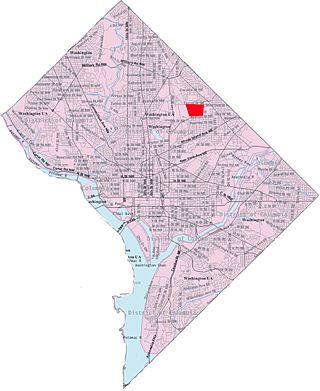
Riggs Park, also known as "Lamond Riggs", is a residential neighborhood in Ward 4 of Northeast Washington, D.C. Riggs Park is contained between Eastern Avenue N.E. to the east, Riggs Road N.E. to the south, North Capitol Street N.W. to the north and west, and the Blair Road Community Garden to the north. Riggs Park is adjacent to the neighborhoods of Queens Chapel, North Michigan Park, and Fort Totten, located in Ward 5 of Northeast Washington D.C. In addition to these neighborhoods, Riggs Park also borders the city/neighborhood Chillum, which is located in Prince George's County, Maryland. The WMATA Red Line train tracks pass through the Riggs Park neighborhood when traveling between the Takoma and Fort Totten Metro Stations. In addition to the WMATA Red Line, the CSX, MARC, and Amtrak train tracks, pass through the Riggs Park neighborhood as well.

Benning Heights is a residential neighborhood located in northeast Washington, D.C. It is bounded by East Capitol Street to the south, Brooks Street NE to the north, 44th Street NE and Benning Road NE to the west, and Division Avenue NE to the east. It is served by the Benning Road Metro Rail station on the Blue Line and Silver Line of the Washington Metro.

Northeast Boundary is small neighborhood located in the northeast quadrant of Washington, D.C., in the United States. Along with the Capitol View neighborhood, it is the easternmost neighborhood of the District of Columbia.

Pleasant Hill is a neighborhood located in Ward 5 of Northeast Washington, D.C. Pleasant Hill is contained between Allison Street NE and Bates Road NE to the north, Taylor Street NE to the south, the Washington Metropolitan Area Red Line tracks to the east, and North Capitol Street NW to the west. Pleasant Hill borders the adjacent neighborhoods of Fort Totten (north), North Michigan Park (northeast), Michigan Park (east), University Heights (south), Petworth (west), Brightwood Park (northwest), and Park View (southwest). It is adjacent to the Catholic University of America and even houses its athletic facilities. Pleasant Hill houses the Catholic University of America's soccer and football fields as well as its Raymond A. DuFour Athletic Center.
Avondale is an unincorporated community in Prince George's County Maryland, United States. It is contained between Eastern Avenue NE to the south, Queens Chapel Road (MD-500) to the east, and the Northwest Branch Anacostia River to the north and west.
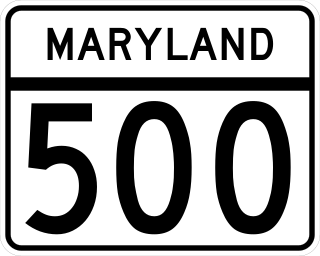
Maryland Route 500 is a state highway in the U.S. state of Maryland. The highway starts at the District of Columbia boundary at Avondale. It is a continuation of Washington D.C.'s Michigan Avenue. As Queens Chapel Road, MD 500 continues north for 2.22 miles (3.57 km) to MD 410 in Hyattsville.
West Virginia Avenue is an avenue in Washington, DC running from K Street NE to New York Avenue NE. It was named after the State of West Virginia which entered the Union in 1863.