Woodley Park (Washington, D.C.)

Last updated
Woodley Park
Cathedral Mansions Apartments 2.jpg
Marriott Wardman Park Tower on a sunny summerday view from east.jpg
Omni Shoreham Hotel from the south on a sunny summer morning (cropped).jpg
Kennedy-Warren Apartment Building - facade (cropped).jpg
St. Thomas Apostle DC (cropped).JPG
Old Woodley Park HD DC.jpg
Connecticut and Calvert (cropped).JPG
Top: Cathedral Mansions (left) and Wardman Park Tower (right); middle: Omni Shoreham Hotel (left), Kenedy-Warren Building (center), and St. Thomas Church (right); bottom: Old Woodley Park Historic District (left) and Connecticut Avenue (right).
DC Neighborhoods - Woodley Park.svg
Country United States
District Washington, D.C.
Quadrant Northwest
Ward3

Woodley Park is a neighborhood in Washington, D.C., located in Northwest D.C. Primarily residential, Woodley Park hosts a commercial corridor of restaurants and shops located along Connecticut Avenue. The neighborhood is noted as the home of the National Zoological Park, part of the Smithsonian Institution.

Contents

History

The area was named after Woodley House, built by Philip Barton Key (the Uncle of Francis Scott Key) in 1801. Woodley has housed many political elites from President Grover Cleveland to World War II Secretary of War Henry Stimson. Nowadays Woodley House serves as the library and administrative building of the Maret School.

The Woodley Park Community Association was established to support the in-town neighborhood quality of life in Woodley Park.

Geography

Taft Bridge connects Woodley Park to Kalorama, over Rock Creek. Taft Bridge, Washington.jpg
Taft Bridge connects Woodley Park to Kalorama, over Rock Creek.

It is bounded on the north by Woodley Road and Klingle Road, on the east by the National Zoo and Rock Creek Park, on the south by Calvert Street, on the southwest by Cleveland Avenue, and on the west by 34th Street.

Adjoining neighborhoods are Cleveland Park to the north, Mount Pleasant and Adams Morgan to the east, Kalorama to the south, Woodland-Normanstone Terrace to the southwest, and Massachusetts Heights to the west.

Landmarks

Embassy of Lebanon Lebanese-embassy-dc050.JPG
Embassy of Lebanon
Old Woodley Park Historic District
Area54 acres (22 ha)
Architectural styleLate 19th And 20th Century Revivals [1]
NRHP reference No. 90000856 [2]
Added to NRHPJune 15, 1990

Straddling Connecticut Avenue south of the National Zoo is a neighborhood of fine early 20th-century row houses, a throwback to the days more than a century ago when developers hoped that this wide avenue that runs northward to the Maryland border would be a boulevard lined with elegant homes. Modern-day Connecticut Avenue north of the small Woodley Park historic district, however, is now mostly filled with high rent, high rise apartment houses — although the city's height limitation restricts them to no more than eight stories, they are considered high-rise by Washington standards.

To the east, the neighborhood's curved streets overhang Rock Creek Park. On the west, they bend on the slope leading to the heights of Mt. Saint Albans, the site of Washington National Cathedral. The stately rows of meticulously designed houses are preserved intact, presenting streetscapes that have changed little for nearly a century. Though busy Connecticut Avenue is always just around the corner, the residential streets are leafy, green, and serene. The neighborhood provides access to several nature trails, including Rock Creek Park, Tregaron Conservancy, and Klingle Valley Trail.

National Zoological Park, part of the Smithsonian Institution. Washington Zoo entrance.jpg
National Zoological Park, part of the Smithsonian Institution.

On Connecticut Avenue, former row houses along the street have been converted into commercial properties, including restaurants, offices and retail shops. Two large hotels are located on Calvert Street (the Omni Shoreham Hotel) and Woodley Road (the Marriott Wardman Park hotel, the second largest hotel in D.C.). At night, the place is a hive of activity, particularly since a shuttle bus (The Circulator) now runs between the Metro stop (Woodley Park/Adams Morgan) to the heart of Adams Morgan and the U Street Corridor. Shops and restaurants lining Connecticut Ave include many chains, but also many local restaurants and shops.

Education

The District of Columbia Public Schools is the public school system. Oyster Adams Bilingual School is the neighborhood K-8 school, formed in 2007 by the merger of James F. Oyster Bilingual Elementary School in Woodley Park and John Quincy Adams Elementary School in Adams Morgan. [3]

Residents are zoned to Oyster Adams, [4] [5] and Jackson-Reed High School. [6]

Transportation

The Klingle Valley Bridge, built in 1932, connects Woodley Park to Cleveland Park over Klingle Valley KILLINGLY VALLEY BRIDGE, CLEVELAND PARK, DISTRICT OF COLUMBIA.jpg
The Klingle Valley Bridge, built in 1932, connects Woodley Park to Cleveland Park over Klingle Valley

Woodley Park is served by the Woodley Park-Zoo/Adams Morgan Metro station, between Dupont Circle and Cleveland Park on the Red Line.

Related Research Articles

<span class="mw-page-title-main">Woodley Park station</span> Washington Metro station

Woodley Park station is an underground station on the Red Line of the Washington Metro. Located at 24th Street and Connecticut Avenue Northwest, it serves the neighborhoods of Woodley Park and Adams Morgan in Northwest Washington.

<span class="mw-page-title-main">Adams Morgan</span> Neighborhood of Washington, D.C.

Adams Morgan, commonly abbreviated as AdMo, is a neighborhood in Washington, D.C., located in Northwest D.C. Adams Morgan is noted as a historic hub for counterculture and as an arts district. It is also known for its popular entertainment district and culinary scene, centered on both 18th Street and Columbia Road.

<span class="mw-page-title-main">Mount Pleasant (Washington, D.C.)</span> Neighborhood of Washington, D.C.

Mount Pleasant is a neighborhood in Washington, D.C., located in Northwest D.C. The neighborhood is primarily residential, with restaurants and stores centered along a commercial corridor on Mt. Pleasant Street. Mount Pleasant is known for its unique identity and multicultural landscape, home to diverse groups such as the punk rock, the Peace Corps and Hispanic Washingtonian communities.

<span class="mw-page-title-main">Northwest (Washington, D.C.)</span> Quadrant in the United States

Northwest is the northwestern quadrant of Washington, D.C., the capital of the United States, and is located north of the National Mall and west of North Capitol Street. It is the largest of the four quadrants of the city, and it includes the central business district, the Federal Triangle, and the museums along the northern side of the National Mall, as well as many of the District's historic neighborhoods.

<span class="mw-page-title-main">Columbia Heights (Washington, D.C.)</span> Neighborhood of Washington, D.C.

Columbia Heights is a neighborhood in Washington, D.C., located in Northwest D.C. The neighborhood is an important retail hub for the area, as home to DC USA mall and to numerous other restaurants and stores, primarily along the highly commercialized 14th Street. Columbia Heights is home to numerous historical landmarks, including Meridian Hill Park, National Baptist Memorial Church, All Souls Church, along with a number of embassy buildings.

<span class="mw-page-title-main">Cleveland Park</span> Neighborhood in Washington, D.C.

Cleveland Park is a residential neighborhood in the Northwest quadrant of Washington, D.C. It is located at 38°56′11″N77°3′58″W and bounded approximately by Rock Creek Park to the east, Wisconsin and Idaho Avenues to the west, Klingle and Woodley Roads to the south, and Rodman and Tilden Streets to the north. Its main commercial corridor lies along Connecticut Avenue NW, where the eponymous Cleveland Park station of the Washington Metro's Red Line can be found; another commercial corridor lies along Wisconsin Avenue. The neighborhood is known for its many late 19th century homes and the historic Art Deco Uptown Theater. It is also home to the William L. Slayton House and the Park and Shop, built in 1930 and one of the earliest strip malls.

<span class="mw-page-title-main">Glover Park</span> Place in the United States

Glover Park is a neighborhood in northwest Washington, D.C., about a half mile north of Georgetown and just west of the United States Naval Observatory and Number One Observatory Circle. Every morning and evening, Glover Park residents can hear the Naval Observatory play the sounding of colors synchronized to the nation's Master Clock. It is named after Charles Carroll Glover.

<span class="mw-page-title-main">Connecticut Avenue</span> Thoroughfare in Washington, D.C., and Maryland

Connecticut Avenue is a major thoroughfare in the Northwest quadrant of Washington, D.C., and suburban Montgomery County, Maryland. It is one of the diagonal avenues radiating from the White House, and the segment south of Florida Avenue was one of the original streets in Pierre (Peter) Charles L'Enfant's plan for Washington. A five-mile segment north of Rock Creek was built in the 1890s by a real-estate developer.

<span class="mw-page-title-main">Florida Avenue</span>

Florida Avenue is a major street in Washington, D.C. It was originally named Boundary Street, because it formed the northern boundary of the Federal City under the 1791 L'Enfant Plan. With the growth of the city beyond its original borders, Boundary Street was renamed Florida Avenue in 1890.

<span class="mw-page-title-main">Rock Creek Railway</span>

The Rock Creek Railway, which operated independently from 1890 to 1895, was one of the first electric streetcar companies in Washington, D.C., and the first to extend into Maryland.

<span class="mw-page-title-main">Cathedral Heights</span> Place in District of Columbia, United States

Cathedral Heights is a neighborhood of Washington, D.C., located in Northwest D.C. Primarily residential, the neighborhood has a commercial corridor of shops and restaurants along Wisconsin Avenue. Cathedral Heights is named for Washington National Cathedral, which sits at the heart of the neighborhood.

<span class="mw-page-title-main">Woodland Normanstone</span> Place in the United States

Woodland Normanstone is a small, residential neighborhood in Northwest Washington, D.C., adjoining the larger neighborhoods of Woodley Park, Massachusetts Avenue Heights, and Observatory Circle.

The Klingle Valley Trail is a trail in the northwest quadrant of Washington, D.C.

<span class="mw-page-title-main">Klingle Valley Bridge</span> United States historic place

The Klingle Valley Bridge, officially known as the Connecticut Avenue Bridge, is an Art Deco steel-arch bridge located near the National Zoological Park on Connecticut Avenue, Northwest in Washington, D.C. The bridge crosses Klingle Valley, running from Macomb Street to Devonshire Place and connecting the Cleveland Park and Woodley Park neighborhoods.

<span class="mw-page-title-main">Outline of Washington, D.C.</span> Overview of and topical guide to District of Columbia

The following outline is provided as an overview of and topical guide to District of Columbia:

<span class="mw-page-title-main">Golden Triangle (Washington, D.C.)</span> US business improvement district

The Golden Triangle is a neighborhood and business improvement district (BID) in Washington, D.C. Covering 43 blocks, it encompasses the western part of Washington's central business district, running from the front yard of the White House's north side to Dupont Circle and from 16th Street NW to 21st Street NW and including sections of K Street and Connecticut Avenue. The commercial neighborhood is home to more than 3,000 organizations, 200 restaurants, 300 shops and retailers, 7 hotels, and 6 national parks.

<span class="mw-page-title-main">Kalorama Triangle Historic District</span> Historic district in Washington, D.C., United States

The Kalorama Triangle Historic District is a mostly residential neighborhood and a historic district in the northwest quadrant of Washington, D.C. The entire Kalorama Triangle neighborhood was listed on the District of Columbia Inventory of Historic Sites (DCIHS) and National Register of Historic Places (NRHP) in 1987. In addition to individually listed landmarks in the neighborhood, the district is home to roughly 350 contributing properties. The neighborhood is roughly bounded by Connecticut Avenue to the west, Columbia Road to the east, and Calvert Street on the north.

<span class="mw-page-title-main">Arthur B. Heaton</span> American architect (1875–1951)

Arthur B. Heaton was an American architect from Washington, D.C. During his 50-year career Heaton designed over 1,000 commissions, including many notable buildings listed on the National Register of Historic Places (NRHP). He was the first supervising architect of the Washington National Cathedral and one of several local architects responsible for designing many of the buildings in the Burleith, Cleveland Park, Kalorama Triangle, and Woodley Park neighborhoods.

<span class="mw-page-title-main">Connecticut Avenue Line</span> Daily bus line in Washington, D.C., US

The Connecticut Avenue Line, designated Route L2, is a daily bus route in Northwest Washington, D.C., United States. The L2 operates seven days a week.

<span class="mw-page-title-main">Robert O. Scholz</span> American architect

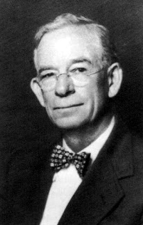
Robert O. Scholz (1895–1978) was an American architect from Washington, D.C., who is considered one of the city's most important Art Deco designers. A native of New York City, his German parents later moved to Chicago, where he studied at the Armour Institute. Scholz briefly served during World War I before moving to Washington, D.C. He worked as an engineer and draftsman before starting his own architectural firm in 1922.

References

  1. Field, Cynthia. "NRHP Nomination Form". April 1990. National Park Service. Retrieved 27 January 2014.
  2. "National Register Information System". National Register of Historic Places . National Park Service. July 9, 2010.
  3. "About Us" (Archive). Oyster Adams Bilingual Elementary School. Retrieved on November 6, 2014.
  4. "Elementary Schools" (2016-2017 School Year). District of Columbia Public Schools. Retrieved on May 27, 2018.
  5. "Middle School Boundary Map" (2016-2017 School Year). District of Columbia Public Schools. Retrieved on May 27, 2018.
  6. "High School Boundary Map" (2016-2017 School Year). District of Columbia Public Schools. Retrieved on May 27, 2018.

38°55′42.4″N77°3′21.5″W / 38.928444°N 77.055972°W / 38.928444; -77.055972