Largo is an unincorporated area and census-designated place in Prince George's County, Maryland, United States. The population was 11,605 at the 2020 census.
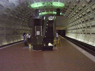
Benning Road station is an island-platformed Washington Metro station in the Benning Ridge neighborhood of Northeast Washington, D.C., United States. The station was opened on November 22, 1980, and is operated by the Washington Metropolitan Area Transit Authority (WMATA). Providing service for the Blue and Silver Lines, the station is located in a residential area near the intersection of Benning Road and East Capitol Street. It is the first station after the Blue and Silver Lines diverge from the Orange Line east of the Anacostia River, and also the last station in the District of Columbia going east.

Columbia Heights is a neighborhood in Washington, D.C., located in Northwest D.C. Bounded by 16th Street NW, W Street NW, Florida Avenue NW, Barry Place NW, Sherman Avenue NW, Spring Road NW, and New Hampshire Avenue NW. neighborhood is an important retail hub for the area, as home to DC USA mall and to numerous other restaurants and stores, primarily along the highly commercialized 14th Street. Columbia Heights is home to numerous historical landmarks, including Meridian Hill Park, National Baptist Memorial Church, All Souls Church, along with a number of embassy buildings.

Cleveland Park is a residential neighborhood in the Northwest quadrant of Washington, D.C. It is located at 38°56′11″N77°3′58″W and bounded approximately by Rock Creek Park to the east, Wisconsin and Idaho Avenues to the west, Klingle and Woodley Roads to the south, and Rodman and Tilden Streets to the north. Its main commercial corridor lies along Connecticut Avenue NW, where the eponymous Cleveland Park station of the Washington Metro's Red Line can be found; another commercial corridor lies along Wisconsin Avenue. The neighborhood is known for its many late 19th century homes and the historic Art Deco Uptown Theater. It is also home to the William L. Slayton House and the Park and Shop, built in 1930 and one of the earliest strip malls.

Deanwood is a neighborhood in Northeast Washington, D.C., bounded by Eastern Avenue to the northeast, Kenilworth Avenue to the northwest, Division Avenue to the southeast, and Nannie Helen Burroughs Avenue to the south.

Shepherd Park is a neighborhood in the northwest quadrant of Washington, D.C. In the years following World War II, restrictive covenants which had prevented Jews and African Americans from purchasing homes in the neighborhood were no longer enforced, and the neighborhood became largely Jewish and African American. Over the past 40 years, the Jewish population of the neighborhood has declined but the neighborhood has continued to support a thriving upper and middle class African American community. The Shepherd Park Citizens Association and Neighbors Inc. led efforts to stem white flight from the neighborhood in the 1960s and 1970s, and it has remained a continuously integrated neighborhood, with very active and inclusive civic groups.

Chevy Chase is a neighborhood in northwest Washington, D.C. It borders Chevy Chase, Maryland.

Woodridge is a residential neighborhood located in Ward 5 of Northeast Washington, D.C. Woodridge is contained between Eastern Avenue N.E. to the east, Taylor Street N.E. to the north, South Dakota Avenue N.E. to the west, and Bladensburg Road N.E. to the south. Its central commercial strips are Rhode Island Avenue NE and Bladensburg Road N.E. Woodridge borders the adjacent neighborhoods of Brookland, Langdon, North Michigan Park, and Fort Lincoln in Northeast Washington D.C. In addition to these neighborhoods in the District of Columbia, Woodridge borders the city of Mount Rainier and town of Cottage City in Maryland. In terms of public transportation, residents of Woodridge have access to the Brookland-CUA and Rhode Island Avenue Metro stations.

Petworth is a neighborhood of Washington, D.C., located in Northwest D.C. While largely residential, Petworth is home to a notable commercial corridor of shops and restaurants, primarily along Georgia Avenue and Upshur Street, as well as a portion of 14th Street. The neighborhood is accessible via the Georgia Ave–Petworth station on the Green Line of the Washington Metro.
Woodley Park is a neighborhood in Washington, D.C., located in Northwest D.C. Primarily residential, Woodley Park hosts a commercial corridor of restaurants and shops located along Connecticut Avenue. The neighborhood is noted as the home of the National Zoological Park, part of the Smithsonian Institution.
Carole Highlands is an unincorporated community in Prince George's County, Maryland, United States. It is contained between East West Highway to the south, University Boulevard to the north, Larch Avenue, Hopewell Avenue, and 15th Avenue to the west, and Riggs Road to the east. Carole Highlands borders the adjacent neighborhoods of Chillum, Green Meadows, Lewisdale, and Langley Park in Prince George's County, while bordering the city of Takoma Park in Montgomery County. For statistical purposes, it is part of the Langley Park census-designated place (CDP). The community also has a community association and non-profit: Carole Highlands Neighborhood Association

Benning Heights is a residential neighborhood located in northeast Washington, D.C. It is bounded by East Capitol Street to the south, Brooks Street NE to the north, 44th Street NE and Benning Road NE to the west, and Division Avenue NE to the east. It is served by the Benning Road Metro Rail station on the Blue Line and Silver Line of the Washington Metro.
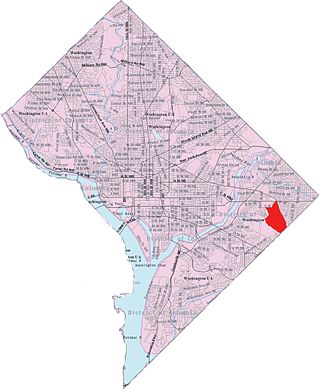
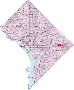
Benning Ridge is a residential neighborhood located in Southeast Washington, D.C. It is bounded by Fort Chaplin Park to the northwest, Southern Avenue to the south, Benning Road to the east, and Ridge Road SE to the west. Benning Ridge is an unusual neighborhood for its location east of the Anacostia River: although it is surrounded by working-class and low-income African American neighborhoods, Benning Ridge is rather affluent, with a diverse population of middle- and upper-middle-class white and black residents. As of 2015 the neighbourhood was one of the top ten most liberal neighbourhoods in Washington D.C..

Washington Highlands is a residential neighborhood in Southeast Washington, D.C., in the United States. It lies within Ward 8. Bounded by Oxon Run Park(Oxon-Run Trail)SE, Livingston Road SE, South Capitol Street SE, Southern Avenue SE, Valley Avenue SE, and 13th Street SE.

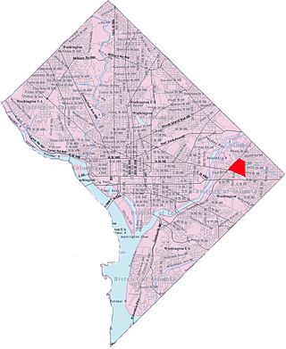
Northeast Boundary is small neighborhood located in the northeast quadrant of Washington, D.C., in the United States. Along with the Capitol View neighborhood, it is the easternmost neighborhood of the District of Columbia.
Central Northeast, also sometimes called Mahaning Heights, is a small neighborhood located in Northeast Washington, D.C., with Fort Mahan Park at its center. It is bounded by Nannie Helen Burroughs Avenue to the north, Benning Road to the south, the tracks of the Washington Metro and Minnesota Ave station to the west, and 44th Street NE to the east.

Lincoln Heights is a residential neighborhood in Northeast Washington, D.C. It is bounded by Nannie Helen Burroughs Avenue NE, Division Avenue NE, East Capitol Street NE, and 58th Street NE.

Randle Highlands is a neighborhood in Southeast Washington, D.C., east of the Anacostia River.

East River Heights is a residential and mixed use neighborhood located in Ward 7 of Washington, DC. It is considered the "downtown" area of the ward and has high walkability ratings. Its borders are East Capital Street, Minnesota Ave, Benning Road up to 41st Street. It is a neighborhood of retired and working people and many children. There is quite a bit of development occurring. The houses are small but have large yards. It is centrally located. It is located between the Minnesota Avenue and Benning Road stations on the Washington Metro.
Benning Terrace is a public housing project of 274 apartments and townhouses in southeast Washington, D.C. located east of the Anacostia River in the Benning Ridge neighborhood. It is known to the natives as "Simple City."