
Georgetown is a historic neighborhood and commercial district of Washington, D.C., in Northwest D.C., situated along the Potomac River. Founded in 1751 in the Province of Maryland, the port of Georgetown predated the establishment of the federal district and the City of Washington by 40 years. Georgetown remained a separate municipality until 1871 when the United States Congress created a new consolidated government for the whole District of Columbia. A separate act, passed in 1895, specifically repealed Georgetown's remaining local ordinances and renamed Georgetown's streets to conform with those in the City of Washington.

Burleith is a neighborhood in Washington, D.C., United States. It is bordered by 35th Street NW to the east, Reservoir Road NW and the historic Georgetown district to the south, Whitehaven Park to the north, and Glover Archbold Park to the west. The neighborhood is home to the Duke Ellington School of the Arts and the Washington International School.

Mount Pleasant is a neighborhood in the northwestern quadrant of Washington, D.C. It is bounded by Rock Creek Park to the north and west; Harvard Street NW to the south; and 16th Street NW to the east. It is north of Adams Morgan and west of Columbia Heights. It is home to about 10,000 people.

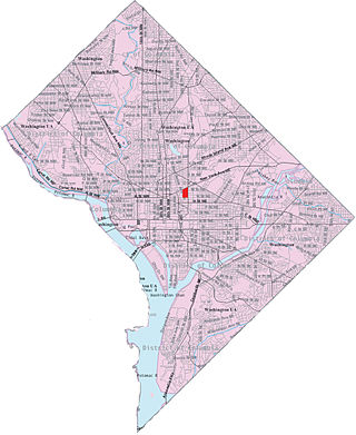
Northwest is the northwestern quadrant of Washington, D.C., the capital of the United States, and is located north of the National Mall and west of North Capitol Street. It is the largest of the four quadrants of the city, and it includes the central business district, the Federal Triangle, and the museums along the northern side of the National Mall, as well as many of the District's historic neighborhoods.

Columbia Heights is a neighborhood in Washington, D.C., located in Northwest D.C. It has diverse demographics, the DC USA shopping mall and many restaurants, BloomBars, Meridian Hill/Malcolm X Park, Howard University, Banneker Recreation Center, and All Souls Church.

Shaw is a neighborhood of Washington, D.C., located in the Northwest quadrant. Shaw is a major entertainment and retail hub, and much of the neighborhood is designated as a historic district, including the smaller Blagden Alley-Naylor Court Historic District. Shaw and the U Street Corridor have historically have been the city's hub for African-American social, cultural, and economic life.
Sursum Corda is a small neighborhood located in Washington, D.C., bounded by North Capitol Street on the east, K Street NW to the south, New Jersey Avenue NW to the west, and New York Avenue NW to the north.
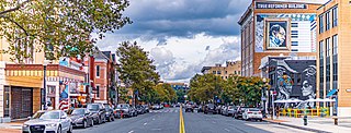
The U Street Corridor, sometimes called Cardozo/Shaw or Cardozo, is a commercial and residential district in Northwest Washington, D.C., most of which also constitutes the Greater U Street Historic District. It is centered along a nine-block stretch of U Street from 9th to 18th Streets, which from the 1920s until the 1960s was the city's black entertainment hub, called "Black Broadway" and "the heart of black culture in Washington, D.C.". After a period of decline following the 1968 riots, the economy picked up with the 1991 opening of the U Street Metro station. Subsequent gentrification diversified the population, which is 67% non-Hispanic White and 18% African American. Since 2013, thousands of residents have moved into new luxury apartment buildings. U Street is now promoted as a "happening" neighborhood for upscale, "hip", and "eclectic" dining and shopping, its live music and nightlife, as well as one of the most significant African American heritage districts in the country.

Massachusetts Avenue is a major diagonal transverse road in Washington, D.C., and the Massachusetts Avenue Historic District is a historic district that includes part of it.

Connecticut Avenue is a major thoroughfare in the Northwest quadrant of Washington, D.C., and suburban Montgomery County, Maryland. It is one of the diagonal avenues radiating from the White House, and the segment south of Florida Avenue was one of the original streets in Pierre (Peter) Charles L'Enfant's plan for Washington. A five-mile segment north of Rock Creek was built in the 1890s by a real-estate developer.
The Columbia Hospital for Women was a hospital located in Washington, D.C. Originally opening in 1866 as a health-care facility for wives and widows of Civil War soldiers, it moved in 1870 from Thomas Circle to its later location at 2425 L Street, NW in the West End neighborhood. The Columbia became a private, non-profit hospital when President Dwight D. Eisenhower signed legislation transferring it to a board of directors in 1953. The facility closed in 2002 and the building was converted into a condominium, The Columbia Residences.

Penn Quarter is a neighborhood of Downtown Washington, D.C., located north of Pennsylvania Avenue, in Northwest D.C. Penn Quarter is roughly equivalent to the city's early downtown core near Pennsylvania Avenue and 7th Street NW, Penn Quarter is an entertainment and commercial hub, home to many museums, theaters, cinemas, restaurants, bars, art galleries and retail shops. Landmarks include the Capital One Arena, the National Portrait Gallery, and the Harman Center for the Arts, among others. The area is also home to a popular farmers market and several food, wine, art, and culture focused festivals.
The streets and highways of Washington, D.C., form the core of the surface transportation infrastructure in Washington, D.C., the federal capital of the United States. Given that it is a planned city, the city's streets follow a distinctive layout and addressing scheme. There are 1,500 miles (2,400 km) of public roads in the city, of which 1,392 miles (2,240 km) are owned and maintained by city government.

Downtown is the central business district of Washington, D.C., located in Northwest D.C. It is the fourth largest central business district in the United States. The "Traditional Downtown" has been defined as an area roughly between Union Station in the east and 16th Street NW in the west, and between the National Mall on the south and Massachusetts Avenue on the north, including Penn Quarter. However, nowadays, Downtown D.C. usually refers to a larger area, as the DC Office of Planning states:
…most residents, workers, and visitors think of Downtown in a broader sense — including areas as far north as Dupont Circle, as far west as Foggy Bottom, and as far east as Capitol Hill. Only about half of the central city workforce is located within the city’s traditional Downtown.

Washington Harbour is a Class-A mixed-use development located at 3000 and 3050 K Street, N.W., in Washington, D.C., in the United States. The southern edge of the development borders the Potomac River on the Georgetown waterfront. Designed by Arthur Cotton Moore, the complex consists of two curved towers and three other buildings attached to them, all of which are in the Postmodern architectural style. The complex contains luxury condominia, offices, retail space, restaurants, and underground parking.
Kingdon Gould III is an American real estate developer, active in the Washington, D.C.-area. He is part of the fifth generation of the Gould family of financiers, philanthropists and diplomats, which includes his father Kingdon Gould, Jr., grandfather Kingdon Gould Sr., great-grandfather George Jay Gould and great-great-grandfather Jay Gould, with associated generations of mothers, siblings, uncles, aunts and cousins.
Vlastimil Koubek was a Czech American architect who designed more than 100 buildings, most of them in the Washington, D.C., metropolitan area. When he died, he had designed buildings worth more than $2 billion. Most of his work is Modernist in style, although he developed a few structures in other vernaculars. He created the site plan for the redevelopment of Rosslyn, Virginia, and his Ames Center anchored the area's economic recovery. He also designed the World Building in Silver Spring, Maryland, which sparked redevelopment of that town's downtown and the L'Enfant Plaza Hotel in Washington, D.C., amongst many other buildings. In 1985, Washingtonian magazine considered him to be one of 20 people "who in the past 20 years had the greatest impact on the way we live and who forever altered the look of Washington." In 1988, The Washington Post newspaper said his Willard Hotel renovation was one of 28 projects in the area which made a signal contribution to the "feel" and look of Washington, D.C.

CityCenterDC is a mixed-use development consisting of two condominium buildings, two rental apartment buildings, two office buildings, a luxury hotel, and public park in downtown Washington, D.C. It encompasses 2,000,000 square feet (190,000 m2) and covers more than five city blocks. The $950 million development began construction on April 4, 2011, on the site of the former Washington Convention Center—a 10.2-acre (4.1 ha) site bounded by New York Avenue NW, 9th Street NW, H Street NW, and 11th Street NW. Most of the development was completed and open for business by summer 2015. The luxury hotel Conrad Washington, DC, opened in February 2019.

William Zeckendorf Jr. was an American real estate developer. Son of William Zeckendorf Sr., he was the second of three generations of one of New York's great real estate dynasties. While keeping a lower profile than his famously flamboyant father, Zeckendorf Jr. was highly successful in his own right. Like his father, he became known for large-scale projects that transformed neighborhoods.

Mount Vernon Triangle is a neighborhood and community improvement district in the northwest quadrant of Washington, D.C. Originally a working-class neighborhood established in the 19th century, present-day Mount Vernon Triangle experienced a decline in the mid-20th century as it transitioned from residential to commercial and industrial use. The neighborhood has undergone significant and rapid redevelopment in the 21st century. It now consists mostly of high-rise condominium, apartment and office buildings. Several historic buildings in the neighborhood have been preserved and are listed on the National Register of Historic Places. Mount Vernon Triangle is now considered a good example of urban planning and a walkable neighborhood.


