Congress Heights

Last updated
Congress Heights
Neighborhood
Map congress heights.jpg
Map of Washington, D.C., with the Congress Heights neighborhood highlighted in red
Coordinates: 38°50′25.5948″N077°00′00″W / 38.840443000°N 77.00000°W / 38.840443000; -77.00000
CountryUnited States
TerritoryWashington, D.C.
WardWard 8
Constructed1890
Government
  Councilmember Trayon White
Congress Heights at the Intersection of 1st and Wayne Pl. SE, April 2018 Congress Heights Washington DC.jpg
Congress Heights at the Intersection of 1st and Wayne Pl. SE, April 2018

Congress Heights is a residential neighborhood in Southeast Washington, D.C., in the United States. The irregularly shaped neighborhood is bounded by the St. Elizabeths Hospital campus, Lebaum Street SE, 4th Street SE, and Newcomb Street SE on the northeast; Shepard Parkway and South Capitol Street on the west; Atlantic Street SE and 1st Street SE (as far as Chesapeake Street SE) on the south; Oxon Run Parkway on the southeast; and Wheeler Street SE and Alabama Avenue SE on the east. Commercial development is heavy along Martin Luther King, Jr. Avenue and Malcolm X Avenue (formerly Portland Street, SE). [1]

Contents

History of the neighborhood

Pre-development years

Map showing the Congress Heights area in 1865, with the bluffs which give the area its name denoted with hatch-marks. Where the two red roads converge is the current intersection of South Capitol Street and Martin Luther King, Jr. Avenue. Asylum Avenue in 1865 - Washington DC.jpg
Map showing the Congress Heights area in 1865, with the bluffs which give the area its name denoted with hatch-marks. Where the two red roads converge is the current intersection of South Capitol Street and Martin Luther King, Jr. Avenue.

Prior to its development, the area known as Congress Heights was forest and farmland. The bay between Poplar Point and Giesborough Point was open water, and would not be filled in and reclaimed for use until the 1880s. The area was served primarily by the Navy Yard Bridge (now known as the 11th Street Bridges), constructed in 1820. [2] The first residential development east of the river was Uniontown (now the neighborhood of Anacostia), begun in 1854. [3] The following year, the federal government constructed the Government Hospital for the Insane (later known as St. Elizabeths Hospital). To serve the hospital, Asylum Avenue (now Martin Luther King, Jr. Avenue) was constructed from the Navy Yard Bridge to the new hospital and then, running on the east side of a line of hills, down to the District-Maryland line. [4]

Additional construction in the area occurred during the American Civil War (1861 to 1865). The United States Department of War constructed the George Washington Young cavalry magazine on 90 acres (360,000 m2) of land on Giesborough Point. [5] Two forts, Fort Carroll (near the present intersection of South Capitol Street and Martin Luther King, Jr. Avenue) and Fort Greble (near the intersection of Martin Luther King, Jr. Avenue and Blue Plains Drive SW), were constructed on the bluffs that began just west and adjacent to Asylum Road. After the war, the 375-acre (1,520,000 m2) Barry Farm housing development for freed slaves opened in 1867 on the north side of the St. Elizabeths campus and was rapidly occupied. [6] Asylum Avenue was named Nichols Avenue in 1879 in honor of St. Elizabeths Hospital superintendent Charles Henry Nichols. [7]

Asylum Avenue/Nichols Avenue was the only major southward road through the area until the development of Congress Heights itself. The only other major street was a military road (now known as Alabama Avenue SE) which ran in an east-northeasterly direction toward other Civil War forts.

Founding of Congress Heights

Congress Heights advertisement - May 17th, 1902 (Washington Times) Congress Heights 1902 advertisement.jpg
Congress Heights advertisement – May 17th, 1902 (Washington Times)

Congress Heights itself was founded in 1890. Colonel Arthur E. Randle, [lower-alpha 1] [9] a successful newspaper publisher, decided to found a settlement east of the river which he called Congress Heights. [10] The Pennsylvania Avenue Bridge (which was replaced by the John Philip Sousa Bridge) began construction in November 1887, [11] and by June 1890 was nearing completion. [12] Randle understood that this new bridge would bring rapid development east of the Anacostia River, and he intended to take advantage of it.

The development was immediately successful. [13] To ensure that his investment continued to pay off, Randle invested heavily in the Belt Railway, a local streetcar company founded in March 1875. [13] [lower-alpha 2] [14] [15] [16] On March 2, 1895, Randle founded the Capital Railway Company to construct streetcar lines over the Navy Yard Bridge and down Nichols Avenue to Congress Heights. [13] [14] The Belt Railway was purchased on June 24, 1898, by the Anacostia and Potomac River Railway Company. [lower-alpha 3] [14] [15] [16] This made Randle a majority owner of the Anacostia and Potomac River Railway. Randle sold his interest in the Capital Railway in 1899, [17] and used this fortune to buy a large section of land known as "East Washington Highlands" at the foot of the Pennsylvania Avenue Bridge. [18] This became the development of Randle Highlands, and the success of that development allowed him to create "North Randle Highlands" (now the neighborhoods of Dupont Park, Penn Branch, and the lower portion of Greenway) In October 1906, The Washington Post called Randle's developments "among the largest real estate enterprises ever successfully carried through in the District." [19]

The rapid development of Congress Heights and the areas adjacent to the streetcar line on Nichols Avenue led the government of the District of Columbia to extend South Capitol Street into the area east of the Anacostia River. The topography of the area largely dictated the route. Beginning near St. Elizabeths Hospital, a line of bluffs extended roughly southward until it reached what is now Chesapeake Street SW. (Fort Greble sat atop the southernmost of these cliffs.) To the west of these bluffs were broad, flat lowlands which provided pleasant views of the Potomac River and the city of Alexandria, Virginia. In 1893, the city surveyed South Capitol along the western side of these bluffs, laying out a broad, grand avenue. [5] Once the bluffs ended, the route followed existing local roads and curved eastward to connect with Livingston Road (now the Indian Head Highway) at the District-Maryland line. But because of the lack of development south of Congress Heights, South Capitol Street was only constructed to its intersection with Nichols Avenue. [20]

20th-century development

From the 1930s until the 1950s, Congress Heights was an almost all-white working-class neighborhood. Many of these white working-class people were rural Southerners and Appalachians who had migrated from Virginia, North Carolina, South Carolina, and Georgia. Many of them worked at the Navy Yard or at nearby Bolling Air Force Base. [21]

Congress Heights was the location of the last working farm within the District of Columbia. George Lindner had been growing vegetables on his farm for over 50 years and it had been in the family since the Civil War. The farm shut down in 1939. [22]

Prior to World War II the D.C. National Guard was housed at Camp Simms. The facility included firing ranges up to 1,000 yards. It was on Alabama Avenue at the intersection of Stanton Road and Barry Farm Housing Project. During World War II, it had anti-aircraft gun emplacements to defend Washington from air attack. After the war, the U.S. Army built a military reserve facility in the central part of Congress Heights. Many early residents worked at the U.S. Naval Gun Factory, which stopped production about 1960, or at the U.S. Naval Research Laboratory.

Congress Heights experienced great urban neglect after World War II. However, in the 21st century, Congress Heights has received a great deal of attention from the city and urban developers. Nineteen development projects worth a total of $455 million are underway or completed in Congress Heights as of November 2006. Among these are a redevelopment of St. Elizabeths West Campus for federal use; a request for proposals from the Washington Metropolitan Area Transit Authority for the area around the Congress Heights Metro station; and a planned redevelopment of Camp Simms as a mixed-use project, including a new Giant Grocery Store, enhancement to an existing shopping center, and 75 new residential units. [23] The ARC cultural arts center, and the Tennis and Learning Center, are nearby on Mississippi Avenue.

The neighborhood is served by the Congress Heights station on the Green Line of the Washington Metro. Most residents live in garden apartments, but there are also older single-family bungalows. Frank W. Ballou High School (rebuilt in 2014) and Hart Middle School serve the neighborhood.

Destination Congress Heights (Congress Heights Main Street) was chartered by the National Trust for Historic Preservation Main Street program in January 2016. Destination Congress Heights is a program created by Congress Heights Community Training & Development Corporation, a nonprofit 501(c)3 organization led by a combination of community development professionals and local volunteers. The main street program is based on the National Trust for Historic Preservation nationally proven model The Main Street Four Point Approach which includes in emphasis in the areas of: organization of commercial revitalization efforts, promotion of neighborhood businesses and business districts, design and economic revitalization. The approach includes an underlying historic preservation ethic and provides local organizations with a mechanism to manage their neighborhood commercial districts and a structure to implement commercial revitalization activities that will achieve the stakeholders' goals for the commercial district.[ citation needed ]

Related Research Articles

<span class="mw-page-title-main">Anacostia</span> Neighborhood in Washington, D.C.

Anacostia is a historic neighborhood in Southeast Washington, D.C. Its downtown is located at the intersection of Good Hope Road and Martin Luther King Jr. Avenue. It is located east of the Anacostia River, after which the neighborhood is named.

<span class="mw-page-title-main">Southeast (Washington, D.C.)</span> Quadrant in the United States

Southeast is the southeastern quadrant of Washington, D.C., the capital of the United States, and is located south of East Capitol Street and east of South Capitol Street. It includes the Capitol Hill and Anacostia neighborhoods, the Navy Yard, the Joint Base Anacostia-Bolling (JBAB), the U.S. Marine Barracks, the Anacostia River waterfront, Eastern Market, the remains of several Civil War-era forts, historic St. Elizabeths Hospital, RFK Stadium, Nationals Park, and the Congressional Cemetery. It also contains a landmark known as "The Big Chair," located on Martin Luther King Jr. Avenue. The quadrant is split by the Anacostia River, with the portion that is west of the river sometimes referred to as "Near Southeast". Geographically, it is the second-smallest quadrant of the city.

<span class="mw-page-title-main">John Philip Sousa Bridge</span> Bridge in Washington, D.C., United States

The John Philip Sousa Bridge, also known as the Sousa Bridge and the Pennsylvania Avenue Bridge, is a continuous steel plate girder bridge that carries Pennsylvania Avenue SE across the Anacostia River in Washington, D.C., in the United States. The bridge is named for famous United States Marine Band conductor and composer John Philip Sousa, who grew up near the bridge's northwestern terminus.

<span class="mw-page-title-main">Independence Avenue (Washington, D.C.)</span>

Independence Avenue is a major east-west street in the southwest and southeast quadrants of the city of Washington, D.C., in the United States, running just south of the United States Capitol. Originally named South B Street, Independence Avenue SW was constructed between 1791 and 1823. Independence Avenue SE was constructed in pieces as residential development occurred east of the United States Capitol and east of the Anacostia River. Independence Avenue SW received its current name after Congress renamed the street in legislation approved on April 13, 1934. Independence Avenue SW originally had its western terminus at 14th Street SW, but was extended west to Ohio Drive SW between 1941 and 1942. The government of the District of Columbia renamed the portion of the road in the southeast quadrant of the city in 1950.

<span class="mw-page-title-main">Streetcars in Washington, D.C.</span> Streetcars that existed in Washington until 1962

Streetcars in Washington, D.C. transported people across the city and region from 1862 until 1962.

<span class="mw-page-title-main">South Capitol Street</span>

South Capitol Street is a major street dividing the southeast and southwest quadrants of Washington, D.C., in the United States. It runs south from the United States Capitol to the D.C.–Maryland line, intersecting with Southern Avenue. After it enters Maryland, the street becomes Indian Head Highway at the Eastover Shopping Center, a terminal or transfer point of many bus routes.

<span class="mw-page-title-main">M Street (Washington, D.C.)</span> Four streets of the same name in Washington, D.C.

The name "M Street" refers to two major roads in the United States capital of Washington, D.C. Because of the Cartesian coordinate system used to name streets in Washington, the name "M Street" can be used to refer to any east-west street located twelve blocks north or south of the dome of the United States Capitol. Thus, in all four quadrants of the city there are streets called "M Street", which are disambiguated by quadrant designations, namely, M Street NW, NE, SW, and SE.

<span class="mw-page-title-main">Barney Circle</span> Neighborhood in the United States

Barney Circle is a small residential neighborhood located between the west bank of the Anacostia River and the eastern edge of Capitol Hill in southeast Washington, D.C., in the United States. The neighborhood is characterized by its sense of community, activism, walkability, and historic feel. The neighborhood's name derives from the eponymous former traffic circle Pennsylvania Avenue SE just before it crosses the John Philip Sousa Bridge over the Anacostia. The traffic circle is named for Commodore Joshua Barney, Commander of the Chesapeake Bay Flotilla in the War of 1812.

<span class="mw-page-title-main">Hillcrest (Washington, D.C.)</span> Neighborhood in Ward 7, United States

Hillcrest is a residential neighborhood in the southeast quadrant of Washington, D.C., United States. Hillcrest is located on the District-Maryland line in Ward 7, east of the Anacostia River.

<span class="mw-page-title-main">Fairlawn (Washington, D.C.)</span> Neighborhood in Ward 8, United States

Fairlawn is a working class and middle class residential neighborhood in southeast Washington, D.C., United States. It is bounded by Interstate 295, Pennsylvania Avenue SE, Minnesota Avenue SE, Naylor Road SE, and Good Hope Road SE.

<span class="mw-page-title-main">Washington Highlands (Washington, D.C.)</span> Residential neighborhood, southeast Washington, D.C., United States

Washington Highlands is a residential neighborhood in Southeast Washington, D.C., in the United States. It lies within Ward 8.

<span class="mw-page-title-main">Good Hope (Washington, D.C.)</span> Neighborhood in Ward 7, United States

Good Hope is a residential neighborhood in southeast Washington, D.C., near Anacostia. The neighborhood is generally middle class and is dominated by single-family detached and semi-detached homes. The year-round Fort Dupont Ice Arena skating rink and the Smithsonian Institution's Anacostia Museum are nearby. Good Hope is bounded by Fort Stanton Park to the north, Alabama Avenue SE to the south, Naylor Road SE to the west, and Branch Avenue SE to the east. The proposed Skyland Shopping Center redevelopment project is within the boundaries of the neighborhood.

<span class="mw-page-title-main">Greenway (Washington, D.C.)</span> Neighborhood in Ward 7, United States

Greenway is a residential neighborhood in Southeast Washington, D.C., in the United States. The neighborhood is bounded by East Capitol Street to the north, Pennsylvania Avenue SE to the south, Interstate 295 to the west, and Minnesota Avenue to the east.

<span class="mw-page-title-main">Naylor Gardens</span> Neighborhood in Ward 7, United States

Naylor Gardens is a small neighborhood located in southeast Washington, D.C. It is bounded by Alabama Avenue SE, 30th Street SE, Erie Street SE, 32nd Street SE, Gainesville Street SE, 31st Street SE, and Naylor Road SE. The neighborhood is located in the area south and east of the Anacostia River.

<span class="mw-page-title-main">Randle Highlands</span> Place in the United States

Randle Highlands is a neighborhood in Southeast Washington, D.C., east of the Anacostia River.

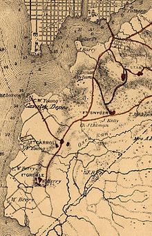
The Anacostia and Potomac River Railroad Company was the fourth streetcar company to operate in Washington, D.C., and the first to cross the Anacostia River. It was chartered in 1870, authorized by Congress in 1875 and built later that year. The line ran from the Arsenal to Union Town. It expanded, adding lines to Congressional Cemetery, Central Market and to the Government Hospital for the Insane; and in the late 1890s it purchased two other companies and expanded their lines. It was reluctant to change its operations, but in 1900 it relented to pressure and became the last company to switch from horsecars to electric streetcars. It was one of the few companies not to be swept up by the two major streetcar companies at the turn of the 20th century, but it could not hold out forever and on August 31, 1912, it was purchased by the Washington Railway and Electric Company and ceased to operate as a unique entity.

<span class="mw-page-title-main">Quadrants of Washington, D.C.</span> Geographical quadrant

Washington, D.C., is administratively divided into four geographical quadrants of unequal size, each delineated by their ordinal directions from the medallion located in the Crypt under the Rotunda of the Capitol. Street and number addressing, centered on the Capitol, radiates out into each of the quadrants, producing a number of intersections of identically named cross-streets in each quadrant. Originally, the District of Columbia was a near-perfect square but contained more than one settlement; the Capitol was to be the center of the City of Washington. Thus, the Capitol was never located at the geographic center of the whole territory, which was eventually north of the Potomac River, consolidated into one city. As a result, the quadrants are of greatly varying size. Northwest is quite large, encompassing over a third of the city's geographical area, while Southwest is little more than a few neighborhoods, large parks, and a military base.

<span class="mw-page-title-main">Anacostia Historic District</span> Historic district in Washington, D.C., United States

The Anacostia Historic District is a historic district in the city of Washington, D.C., comprising approximately 20 squares and about 550 buildings built between 1854 and 1930. The Anacostia Historic District was added to the National Register of Historic Places in 1978. "The architectural character of the Anacostia area is unique in Washington. Nowhere else in the District of Columbia does there exist such a collection of late-19th and early-20th century small-scale frame and brick working-class housing."

<span class="mw-page-title-main">Martin Luther King Jr. Avenue</span> Street in District of Columbia, USA

Martin Luther King Jr. Avenue is a major street in the District of Columbia traversing through both the Southwest and Southeast quadrants.

<span class="mw-page-title-main">Pennsylvania Avenue Bridge (1890)</span> Bridge in United States of America

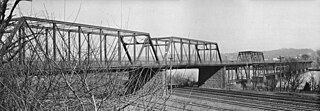
The Pennsylvania Avenue Bridge was a crossing of the Anacostia River in Washington, DC at the site of the present John Philip Sousa Bridge. It was constructed in 1890 and demolished around 1939.

References

Notes
  1. Randle, a graduate of the University of Pennsylvania, received the commission of colonel in the Mississippi State Militia from Andrew H. Longino, Governor of the state of Mississippi, in 1902.
  2. The Capitol, North O Street, and South Washington Railway Company was chartered by Congress on March 3, 1875. By act of Congress enacted on February 18, 1893, it changed its name to the Belt Railway.
  3. The Anacostia and Potomac River Railway Company was founded on May 19, 1872, but not chartered by Congress until February 18, 1875.
Citations
  1. "Subchapter IV. Public Space Names and Commemorative Works". D.C. Law Library. Retrieved 2021-07-22. Designation of Malcolm X Avenue: Section 2 of D.C. Law 9-225 provided that the Council of the District of Columbia designates the portion of Portland Street, S.E., between 9th Street, S.E. and South Capitol Street, S.E., as Malcolm X Avenue.
  2. Croggon, James (July 7, 1907). "Old 'Burnt Bridge'". Washington Evening Star.
  3. Burr 1920, pp. 171–172.
  4. Benedetto, Du Vall & Donovan 2001, p. 201.
  5. 1 2 Committee on Interstate and Foreign Commerce 1894, p. 3.
  6. Davidson & Malloy 2009, pp. 132–133.
  7. Evelyn, Dickson & Ackerman 2008, p. 286.
  8. Tom (2012-04-29). "Congress Heights: The Healthiest and Most Delightful Suburb of Washington". Ghosts of DC. Retrieved 2019-02-25.
  9. "Col. Randle Kills Self in California". The Washington Post. July 5, 1929.
  10. General Services Administration 2012, p. 4—27.
  11. "It Was East End Day". The Washington Post. August 26, 1890.
  12. "A Bridge Celebration". The Washington Post. June 3, 1890.
  13. 1 2 3 Proctor, Black & Williams 1930, p. 732.
  14. 1 2 3 "Electric Railways". Municipal Journal & Public Works. February 26, 1908. p. 252.
  15. 1 2 Fennell 1948, p. 15.
  16. 1 2 Tindall 1918, pp. 39–41.
  17. Tindall 1918, pp. 41.
  18. Smith 2010, pp. 402–403.
  19. "New Suburb Opens". The Washington Post. October 25, 1906.
  20. "Plans for Street Projects Told By Whitehurst". The Washington Post. September 24, 1940.
  21. "A Brief History of White People in Southeast". Washington City Paper. Retrieved 2019-05-03.
  22. Tom (2013-08-12). "Last Farm in the District is Doomed". Ghosts of DC. Retrieved 2019-02-25.
  23. Washington DC Economic Partnership 2014, p. 15.

Bibliography