Barry Farm

Last updated
Barry Farm
Map barry farm.jpg
Barry Farm within the District of Columbia
Country United States
District Washington, D.C.
WardWard 8
Government
  Councilmember Trayon White

Barry Farm is a neighborhood in Southeast Washington, D.C., located east of the Anacostia River and bounded by the Southeast Freeway to the northwest, Suitland Parkway to the northeast and east, and St. Elizabeths Hospital to the south. The neighborhood was renowned as a significant post-Civil-War settlement of free Blacks and freed slaves established by the Freedmen's Bureau. [1] The streets were named to commemorate the Union generals, Radical Republicans, and Freedmen's Bureau officials who advanced the rights of Black Americans during the Civil War and Reconstruction: Howard Road SE for General Oliver O. Howard; Sumner Road SE for Massachusetts Senator Charles Sumner; Wade Road SE for Ohio Senator Benjamin Wade; Pomeroy Road SE for Kansas Senator Samuel C. Pomeroy; Stevens Road SE for Pennsylvania Congressman Thaddeus Stevens, [2] and Nichols Avenue (now Martin Luther King Jr. Avenue SE) for Henry Nichols who was the first superintendent of Saint Elizabeth's Hospital (Formerly called the Government Insane Asylum). [3] The neighborhood name is not a reference to the late former mayor of Washington, D.C., Marion Barry, but coincidentally has the same spelling.[ citation needed ]

Contents

History

The neighborhood of Barry Farm at the intersection of Eaton Rd. and Firth Sterling Ave. before, April 2018, prior to redevelopment Barry Farm Washington DC.jpg
The neighborhood of Barry Farm at the intersection of Eaton Rd. and Firth Sterling Ave. before, April 2018, prior to redevelopment

In 1867, the Freedmen's Bureau (officially the U.S. Bureau of Refugees, Freedmen, and Abandoned Lands) bought a 375-acre farm from Julia Barry, a white landowner and recent owner of enslaved people, enabling the transformation of Barry's Farm into a thriving, independent community of formerly enslaved and free-born African Americans. [4] [5] The Commissioner of the Freedmen's Bureau, General Oliver O. Howard, had asked Black migrants squatting in temporary structures at Meridian Hill, what might help them to become self-supporting. [6] They said, "Land! Give us land!" Howard promised to acquire land near the city. He then transferred $52,000 from the refugees' and freedmen's fund to be held in trust by himself, Senator Samuel C. Pomeroy, and John R. Elvans for the use of three institutions: Howard University, Richmond Normal School, and St. Augustine Normal School in Raleigh. They used some of these funds to purchase Barry's Farm. The Bureau sub-divided the farm into one-acre plots, which the freedmen could purchase over a period of seven years. For an additional $76, they could buy lumber to begin constructing a house. By 1869, money from the sale of the land, reportedly $31,178.12 (~$634,301 in 2023), had been returned to the fund and distributed to the three institutions listed above. [7]

Barry Farm was initially a large homestead, stretching all the way to 13th Street on the east, Poplar Point on the West, and the present-day Morris Road SE on the north. In 1871, the area between 13th Street, Sheridan Road, and Martin Luther King Jr. Avenue SE (then known as Nichols Avenue), residents renamed the area Hillsdale. Railroad tracks laid around 1913 cut off Barry Farm from Poplar Point. The 1940s construction of a Suitland Parkway, originally a military highway from Bolling Field to Camp Springs, MD, further isolated the neighborhood between busy traffic arteries, required the demolition of nearly 100 houses, and displaced more than 600 residents. [8] [9] Beginning in the late 1950s, I-295, or the Anacostia Freeway, further restricted access to and visibility of the Anacostia River. Only a few old frame houses, mostly along Wade Road just at the edge of the thicket that separates Barry Farm from St. Elizabeth's Hospital, resemble those of the original Freedman's community.

The National Capital Housing Authority built the 442-unit Barry Farm Dwellings public housing project in 1943. [10] Barry Farm was built with two- to four-bedroom town houses, with some later combined to create six-bedroom units, and a recreation center. [11]

Tenant activism and community life

Residents organized over the years both to pressure the city for assistance and to protect and support each other. Their actions brought them to the forefront of the civil rights movement. In the summer of 1949, Barry Farm-Hillsdale youth—Richard Robinson, Carl Contee, Richard Cook, Clarence "Dusty" Prue, Everett and Eugene "Mann" McKenzie, Toussaint Pierce, James Chester Jennings Jr, and Otis, Thomas and Bill Anderson—tried to enter the Anacostia Pool without success and continued to try over several days. Legally, the public pools were not segregated, but in practice this was a white segregated pool. There were violent clashes between hundreds of Whites and African Americans. The pool was closed, and the following year all the public pools were desegregated. [12]

In the 1940s, there was just one junior high and no high schools for African Americans east of the Anacostia River. [13] In 1950, Barry Farm Dwelling residents requested that they be admitted to the new, white-segregated Sousa Junior High and that the school be integrated. Their complaint became Bolling v. Sharpe and was one of several companion cases to Brown v. Board of Education . In 1954, the U.S. Supreme Court unanimously declared that segregated public education was inherently unequal, violated the Equal Protection Clause and the right to due process, and therefore was unconstitutional. [14]

In the 1960s, there were new tenant organizing groups. The Band of Angels, a tenants' council made up of women and led by Stevens Road residents Lillian Wright and Etta Mae Horn, was one such group. The Angels' first achievement was an urgently needed $1.5 million renovation of Barry Farm Dwellings. Etta Horn later became an influential civil rights leader and served as vice chair of the National Welfare Rights Organization.

Since 1975, Barry Farm has been the home to Barry Farms Community Basketball League. This summer league was renamed the Goodman League after community activist and Barry Farm Recreation Center counselor George Goodman. [15] The Goodman League features current and former NBA players, college players, and participants from various communities. The Barry Farm Beavers football team also plays at the recreation center.

In 1982, Barry Farm Dwellings residents, including Gladys Bunker, started a food co-op. The food co-op lasted for at least four years and accepted food stamps. Cornbread Givens and the Poor People's Development Foundation helped the co-op organizers. [16]

In 1997, the Capital Area Community Food Bank and Community Educational Economic Development worked with Barry Farm Dwellings residents to start a farm. [17]

Notable residents

Demolition and preserved elements

In the 1940s, government agencies sought to destroy and completely redevelop the Barry Farm-Hillsdale community. Two reasons have been suggested: 1) the community's "inability "to pay for municipal services" through the collection of real estate taxes" and 2) these government agencies' desire to clear downtown Washington, DC, of African Americans and move them to Barry Farm-Hillsdale and Marshall Heights. [5] The residents successfully stopped this redevelopment, but continually had to battle future destruction.

Through the city's New Communities Initiative and the Federal Choice program (the new HOPE VI), the DC Government demolished almost all of Barry Farm to redevelop Barry Farm from single-use public housing where households pay 30% of their incomes to reside in the community, into a mixed-use, higher density community with 1,600 units including homes for sale. In 2013, about 50 Barry Farm residents teamed up with community organizing group Empower DC. [21] They formed the Barry Farm Tenants and Allies Association to stop the city from evicting them from their homes before new housing was built, to demand that the redeveloped site match the intentions of the site's original design in providing sufficient green space, and to guarantee their right to return.

Barry Farm redevelopment in southeast Washington, D.C.

From April 2018 until January 2019, hundreds of families were relocated from Barry Farm, and early 2019, demolition began. [22] The Barry Farm Tenants and Allies Association successfully won a historic landmark designation for five public housing buildings that were home to well-known activists. [23] Other than a recreation center, these were the only buildings that remained on the site as of 2022.

See also

Related Research Articles

<span class="mw-page-title-main">Anacostia</span> Neighborhood in Washington, D.C.

Anacostia is a historic neighborhood in Southeast Washington, D.C. Its downtown is located at the intersection of Good Hope Road and Martin Luther King Jr. Avenue. It is located east of the Anacostia River, after which the neighborhood is named.

<span class="mw-page-title-main">Southeast (Washington, D.C.)</span> Quadrant in the United States

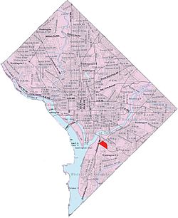
Southeast is the southeastern quadrant of Washington, D.C., the capital of the United States, and is located south of East Capitol Street and east of South Capitol Street. It includes the Capitol Hill and Anacostia neighborhoods, the Navy Yard, the Joint Base Anacostia-Bolling (JBAB), the U.S. Marine Barracks, the Anacostia River waterfront, Eastern Market, the remains of several Civil War-era forts, historic St. Elizabeths Hospital, RFK Stadium, Nationals Park, and the Congressional Cemetery. It also contains a landmark known as "The Big Chair," located on Martin Luther King Jr. Avenue. The quadrant is split by the Anacostia River, with the portion that is west of the river sometimes referred to as "Near Southeast". Geographically, it is the second-smallest quadrant of the city.

<span class="mw-page-title-main">Congress Heights</span> Neighborhood in Washington, D.C., U.S.

Congress Heights is a residential neighborhood in Southeast Washington, D.C., in the United States. The irregularly shaped neighborhood is bounded by the St. Elizabeths Hospital campus, Lebaum Street SE, 4th Street SE, and Newcomb Street SE on the northeast; Shepard Parkway and South Capitol Street on the west; Atlantic Street SE and 1st Street SE on the south; Oxon Run Parkway on the southeast; and Wheeler Street SE and Alabama Avenue SE on the east. Commercial development is heavy along Martin Luther King, Jr. Avenue and Malcolm X Avenue.

<span class="mw-page-title-main">Hillcrest (Washington, D.C.)</span> Neighborhood in Ward 7, United States

Hillcrest is a residential neighborhood in the southeast quadrant of Washington, D.C., United States. Hillcrest is located on the District-Maryland line in Ward 7, east of the Anacostia River.

<span class="mw-page-title-main">Bellevue (Washington, D.C.)</span> Neighborhood in District of Columbia, Washington, United States

Bellevue is a residential neighborhood in far Southeast and Southwest in Washington, D.C., United States. It is bounded by South Capitol Street, one block of Atlantic Street SE, and 1st Streets SE and SW to the north and east; Joliet Street SW and Oxon Run Parkway to the south; Martin Luther King Jr. Avenue SE, Shepherd Parkway, 2nd Street SW, and Xenia Street SW to the west. Bellevue was created from some of the earliest land patents in Maryland, and draws its name from a 1795 mansion built in the area. Subdivisions began in the 1870s, but extensive residential building did not occur until the early 1940s. Bellevue is adjacent to a number of federal and city agency buildings.

<span class="mw-page-title-main">Fairlawn (Washington, D.C.)</span> Neighborhood in Ward 8, United States

Fairlawn is a working class and middle class residential neighborhood in southeast Washington, D.C., United States. It is bounded by Interstate 295, Pennsylvania Avenue SE, Minnesota Avenue SE, Naylor Road SE, and Good Hope Road SE.

<span class="mw-page-title-main">Washington Highlands (Washington, D.C.)</span> Residential neighborhood, southeast Washington, D.C., United States

Washington Highlands is a residential neighborhood in Southeast Washington, D.C., in the United States. It lies within Ward 8.

<span class="mw-page-title-main">Good Hope (Washington, D.C.)</span> Neighborhood in Ward 7, United States

Good Hope is a residential neighborhood in southeast Washington, D.C., near Anacostia. The neighborhood is generally middle class and is dominated by single-family detached and semi-detached homes. The year-round Fort Dupont Ice Arena skating rink and the Smithsonian Institution's Anacostia Museum are nearby. Good Hope is bounded by Fort Stanton Park to the north, Alabama Avenue SE to the south, Naylor Road SE to the west, and Branch Avenue SE to the east. The proposed Skyland Shopping Center redevelopment project is within the boundaries of the neighborhood.

<span class="mw-page-title-main">Greenway (Washington, D.C.)</span> Neighborhood in Ward 7, United States

Greenway is a residential neighborhood in Southeast Washington, D.C., in the United States. The neighborhood is bounded by East Capitol Street to the north, Pennsylvania Avenue SE to the south, Interstate 295 to the west, and Minnesota Avenue to the east.

<span class="mw-page-title-main">Kenilworth (Washington, D.C.)</span> Place in the United States

Kenilworth is a residential neighborhood in Northeast Washington, D.C., located on the eastern bank of the Anacostia River and just inside the D.C.-Maryland border. A large public housing complex, Kenilworth Courts, dominates the area. The neighborhood is famous for the Kenilworth Park and Aquatic Gardens, a national park whose centerpiece is a series of ponds carved out of Anacostia River marshland. Visitors come especially during June and July to see the beautiful blooming water lilies and lotus flowers. In 1895 the name “Kenilworth” was first applied to the area by white real estate developer Allen Mallery, who named this neighborhood after Kenilworth Castle in England, the ruins of which can still be seen today in Warwickshire. Kenilworth Park, which includes the Kenilworth-Parkside Recreation Center, also carries the neighborhood name, though most of the park's area is actually located adjacent to the modern neighborhoods of Parkside and Eastland Gardens.

<span class="mw-page-title-main">Marshall Heights (Washington, D.C.)</span> Residential neighborhood in Washington, D

Marshall Heights is a residential neighborhood in Southeast Washington, D.C. It is bounded by East Capitol Street, Central Avenue SE, Southern Avenue, Fitch Street SE, and Benning Road SE. It was an undeveloped rural area occupied by extensive African American shanty towns, but the neighborhood received nationwide attention after a visit by First Lady Eleanor Roosevelt in 1934, which led to extensive infrastructure improvements and development for the first time. In the 1950s, Marshall Heights residents defeated national legislation designed to raze and redevelop the neighborhood. Queen Elizabeth II of the United Kingdom visited the area in 1991, at a time when Marshall Heights was in the throes of a violent crack cocaine epidemic. Limited redevelopment has occurred in the neighborhood, which was the site of two notorious child murders in 1973.

<span class="mw-page-title-main">River Terrace (Washington, D.C.)</span> Neighborhood in Ward 7, United States

River Terrace is an urban cul-de-sac neighborhood in Northeast Washington, D.C., on the eastern bank of the Anacostia River. River Terrace is Washington, DC's only planned unit development that has an unimpeded connection to and relationship with the Anacostia River.

<span class="mw-page-title-main">Woodland (Washington, D.C.)</span> Place in the United States

Woodland is a small residential and industrial neighborhood in Southeast Washington, D.C. Woodland lies in Washington's Ward 8, among the poorest and least developed of the city's wards. Like the neighborhoods around it, Woodland is almost exclusively African American. Woodland is bounded by Ainger Place SE to the north; Alabama Avenue SE and Knox Place SE to the east; Hartford Street SE to the south; and Langston Place SE, Raynolds Place SE, and Erie Street SE to the southwest. Fort Stanton Park forms the northwest and northern border of the neighborhood.

<span class="mw-page-title-main">H. R. Crawford</span> American politician (1939–2017)

Hazle Reid Crawford was an American real estate developer and Democratic politician in Washington, D.C.

<span class="mw-page-title-main">Anacostia Historic District</span> Historic district in Washington, D.C., United States

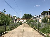
The Anacostia Historic District is a historic district in the city of Washington, D.C., comprising approximately 20 squares and about 550 buildings built between 1854 and 1930. The Anacostia Historic District was added to the National Register of Historic Places in 1978. "The architectural character of the Anacostia area is unique in Washington. Nowhere else in the District of Columbia does there exist such a collection of late-19th and early-20th century small-scale frame and brick working-class housing."

<span class="mw-page-title-main">Martin Luther King Jr. Avenue</span> Street in District of Columbia, USA

Martin Luther King Jr. Avenue is a major street in the District of Columbia traversing through both the Southwest and Southeast quadrants.

<span class="mw-page-title-main">Solomon G. Brown</span> American poet (1829–1906)

Solomon G. Brown was the first African-American employee of the Smithsonian Institution. He was also a poet, lecturer, and scientific technician. He joined the Smithsonian in 1852 and remained there for fifty-four years until he retired in 1906. He was also a local civic leader, organizing and leading many educational and community organizations. He served in the Washington D.C. House of Delegates from 1871 to 1874.

<span class="mw-page-title-main">Fort Stanton, Washington, D.C.</span> Place in the United States

Fort Stanton is a residential neighborhood in Southeast Washington, D.C. It is bounded by Erie St SE. to the north, Suitland Parkway to the south, 16th St. SE to the west, and 19th Pl SE to the east. The neighborhood is named after the nearby civil War defense Fort Stanton. Fort Stanton is part of Ward 7, represented by Vince Gray. Fort Stanton is situated between the neighborhoods of Anacostia, to the north, Barry Farm to the west, Garfield Heights to the East, and Douglass to the south.

<span class="mw-page-title-main">Julia Dorsey (suffragist)</span> African-American suffragist (c. 1850–1919)

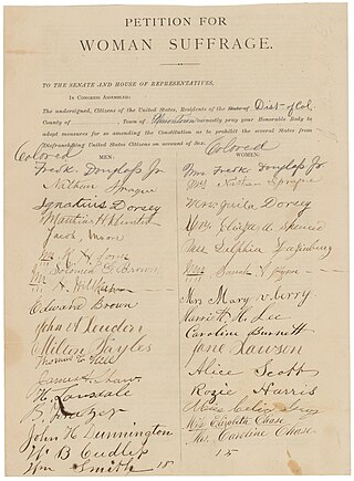
Julia Dorsey was an African American suffragist.

References

  1. Cantwell, Thomas J. (1976). "Anacostia: Strength in Adversity". Records of the Columbia Historical Society, Washington, D.C. 1973–1974: 331.
  2. Muller, John (31 January 2013). "Barry Farm street names reflect post-Civil War history". Greater Greater Washington. Retrieved 28 March 2023.
  3. Anacostia's old street names reveal little-known history by John Muller (Contributor) April 6, 2011
  4. "Barry Farm Site, African American Heritage Trail". Cultural Tourism DC. Retrieved 28 March 2023.
  5. 1 2 Amos, Alcione M. (2021). Barry Farm - Hillsdale in Anacostia: A Historic African American Community. Charleston, DC: The History Press. ISBN   9781467147699.
  6. Carpenter, John A. (1964). Sword and Olive Branch: Oliver Otis Howard. Univ. of Pittsburgh Press. p. 185.
  7. Everly, Elaine Cutler (1971). The Freedmen's Bureau in the National Capital. PhD Dissertation, Department of History, The George Washington University.
  8. "Division and Displace, 1940s". Anacostia Community Museum.
  9. "NCHA Finds Homes for 99 Families: Groups Were Evicted To Make Way for New Bolling Field Military Road". No. B1. Washington Post. Sep 10, 1943.
  10. "The Barry Administration Reports to the People on Public Housing". GWU Special Collections, John A. Wilson Papers, MS2190, Box 8, File 2, "Housing legislation - ideas". June 1986.
  11. "Barry Farm Recreation Center". DPR.
  12. Amos, Alcione M. (2021). Barry Farm-Hillsdale in Anacostia. Charleston, SC: The History Press. pp. 115–120. ISBN   9781439671863.
  13. DC Historic Preservation Office (4 February 2021). "Barry Farm Dwellings: A Struggle for Civil Rights in Southeast DC".
  14. 1 2 DC Historic Preservation Office (4 February 2021). "Barry Farm Dwellings: A Struggle for Civil Rights in Southeast DC". Barry Farm Dwellings. Retrieved 28 March 2023.
  15. "About The Goodman League". The Goodman League.
  16. Sugarman, Carole (December 10, 1986). "Gladys Bunker & the Fresh Ideal: Co-op Brings Fruit & Vegetables to Low-Income in Anacostia". The Washington Post.
  17. O'Neil, L. Peat (August 14, 1997). "In SW Tract, The Future Is Cultivated". The Washington Post.
  18. Banks, James G.; Banks, Peter S (2004). The Unintended Consequences: Family and Community, the Victims of Isolated Poverty. Lanham, MD: University Press of America, Inc.
  19. "Solomon Brown: First African American Employee at the Smithsonian Institution". Smithsonian Institution Archives.
  20. "Etta Horn". Anacostia Community Museum.
  21. Milloy, Cortland (Oct 28, 2014). "Initiative to revitalize Barry Farm is little more than an urban dispersal plan". Washington Post.
  22. "With Barry Farm All but Abandoned, the Fight for its Future is Just Beginning". East of the River News. 12 March 2019.
  23. "DC Legacy Project".

Further reading

38°51′33″N76°59′57″W / 38.8593°N 76.9991°W / 38.8593; -76.9991