
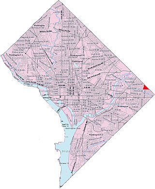
Minnesota Avenue station is an island-platformed Washington Metro station in the Central Northeast/Mahaning Heights neighborhood of Northeast Washington, D.C., United States. The station was opened on November 20, 1978, and is operated by the Washington Metropolitan Area Transit Authority (WMATA). Providing service for the Orange Line, the station is the last station East Of The River, and the last above ground station for westbound trains until East Falls Church; west of the station, trains cross over the Anacostia River, then curve over RFK Stadium parking lots before descending underground.

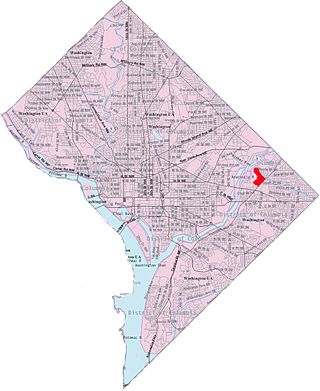
Deanwood station is an island-platformed Washington Metro station in the Deanwood neighborhood of Northeast Washington, D.C., United States. The station was opened on November 20, 1978, and is operated by the Washington Metropolitan Area Transit Authority (WMATA). Providing service for only the Orange Line, the station is the final station in the District of Columbia going east. The station is located at Minnesota Avenue and 48th Street Northeast. It is architecturally similar to its sister station, Minnesota Avenue.

Southeast is the southeastern quadrant of Washington, D.C., the capital of the United States, and is located south of East Capitol Street and east of South Capitol Street. It includes the Capitol Hill and Anacostia neighborhoods, the Navy Yard, the Joint Base Anacostia-Bolling (JBAB), the U.S. Marine Barracks, the Anacostia River waterfront, Eastern Market, the remains of several Civil War-era forts, historic St. Elizabeths Hospital, RFK Stadium, Nationals Park, and the Congressional Cemetery. It also contains a landmark known as "The Big Chair," located on Martin Luther King Jr. Avenue. The quadrant is split by the Anacostia River, with the portion that is west of the river sometimes referred to as "Near Southeast". Geographically, it is the second-smallest quadrant of the city.
Northeast is the northeastern quadrant of Washington, D.C., the capital of the United States. It encompasses the area located north of East Capitol Street and east of North Capitol Street.

Deanwood is a neighborhood in Northeast Washington, D.C., bounded by Eastern Avenue to the northeast, Kenilworth Avenue to the northwest, Division Avenue to the southeast, and Nannie Helen Burroughs Avenue to the south.

Queens Chapel is a mostly residential neighborhood with commercial elements located in Ward 5 of Northeast Washington, D.C.

Benning is a residential neighborhood located in Ward 7 of Northeast Washington, D.C. It is bounded by East Capitol Street to the south, Minnesota Avenue to the west, and Benning Road on the north and east. It is served by the Benning Road station on the Blue and Silver Lines of the Washington Metro.

Benning Heights is a residential neighborhood located in northeast Washington, D.C. It is bounded by East Capitol Street to the south, Brooks Street NE to the north, 44th Street NE and Benning Road NE to the west, and Division Avenue NE to the east. It is served by the Benning Road Metro Rail station on the Blue Line and Silver Line of the Washington Metro.
Burrville is a neighborhood located in Northeast Washington, D.C., east of the Anacostia River. It is triangular in area, bounded by Nannie Helen Burroughs Avenue to the south, Division Avenue to the northwest, and Eastern Avenue to the northeast.

Fairfax Village is a small neighborhood of garden apartments and townhouses located in southeast Washington, D.C. in the Hillcrest area. It is bound by Alabama Avenue SE to the northwest, Pennsylvania Avenue SE to the northeast, Suitland Road to the southwest, and Southern Avenue to the east.

Fort Dupont is a residential neighborhood located in southeast Washington, D.C., east of the Anacostia River. It is bounded by East Capitol Street to the north, Fort Dupont Park to the south, Minnesota Avenue to the west, and Fort Chaplin Park to the east and northeast. Fort Dupont has a population of approximately 7,050.

Garfield Heights is a residential neighborhood in Southeast Washington, D.C., bordering Prince George's County, Maryland. Garfield Heights contains both apartment units and single-family detached houses.
Shipley Terrace, formerly known as Randle Heights, is a large residential neighborhood in Southeast Washington, D.C., bordering Prince George's County, Maryland. The neighborhood, named after a former public housing complex in the neighborhood, which was largely occupied by low-income housing – primarily walkup and garden unit apartments. This neighborhood now has a mix of townhome communities, large single-family-home communities, as well as some low-income housing. It is a model neighborhood for the Hope VI revitalization Grant Program.

Northeast Boundary is small neighborhood located in the northeast quadrant of Washington, D.C., in the United States. Along with the Capitol View neighborhood, it is the easternmost neighborhood of the District of Columbia.

Central Northeast, also sometimes called Mahaning Heights, is a small neighborhood located in Northeast Washington, D.C., with Fort Mahan Park at its center. It is bounded by Nannie Helen Burroughs Avenue to the north, Benning Road to the south, the tracks of the Washington Metro and Minnesota Ave station to the west, and 44th Street NE to the east.

Kenilworth is a residential neighborhood in Northeast Washington, D.C., located on the eastern bank of the Anacostia River and just inside the D.C.-Maryland border. A large public housing complex, Kenilworth Courts, dominates the area. The neighborhood is famous for the Kenilworth Park and Aquatic Gardens, a national park whose centerpiece is a series of ponds carved out of Anacostia River marshland. Visitors come especially during June and July to see the beautiful blooming water lilies and lotus flowers. In 1895 the name “Kenilworth” was first applied to the area by white real estate developer Allen Mallery, who named this neighborhood after Kenilworth Castle in England, the ruins of which can still be seen today in Warwickshire. Kenilworth Park, which includes the Kenilworth-Parkside Recreation Center, also carries the neighborhood name, though most of the park's area is actually located adjacent to the modern neighborhoods of Parkside and Eastland Gardens.

Lincoln Heights is a residential neighborhood in Northeast Washington, D.C. It is bounded by Nannie Helen Burroughs Avenue NE to the north, Blaine Street NE to the south, Division Avenue NE to the east, and 49th Street NE to the west.
Mayfair or Parkside-Mayfair is a residential neighborhood in Northeast Washington, D.C., United States., on the eastern bank of the Anacostia River. It is bounded by Jay Street NE on the north, Foote Street on the south, Kenilworth Terrace and Anacostia Avenue on the west, and Kenilworth Avenue on the east. Mayfair is encircled by Jay Street and Hayes St., which met at the back of the neighborhood.

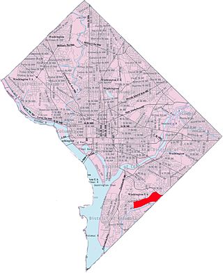
Twining is a neighborhood in Southeast Washington, D.C., near the eastern bank of the Anacostia River. It is bounded by Minnesota Avenue NE to the northeast, Branch Avenue to the northwest, and Pennsylvania Avenue to the south. The Fort Dupont year-round ice skating rink, and the Smithsonian's Anacostia Neighborhood Museum are nearby.

Penn Branch is a neighborhood in Southeast Washington, D.C., east of the Anacostia River. It is bounded by Pennsylvania Avenue SE to the south; Pope Branch Park and Pope Creek to the north; Branch Avenue to the west; and Fort Davis Park to the east. ‘Penn Branch’, takes its name from its location at the intersection of two major thoroughfares, Pennsylvania and Branch Avenue.

