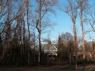
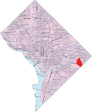
Fort Dupont neighborhood at the intersection of Ridge Road and C St. SE
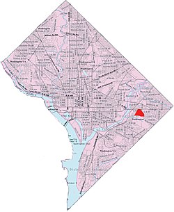
Fort Dupont is a residential neighborhood located in southeastWashington, D.C., east of the Anacostia River. It is bounded by East Capitol Street to the north, Fort Dupont Park to the south, Minnesota Avenue to the west, and Fort Chaplin Park to the east and northeast. Fort Dupont has a population of approximately 7,050.[1]
Fort Dupont is adjacent to Fort Dupont Park, the grounds of a Civil War-era fort that was constructed for the defense of Washington. Fort Dupont is a distinct neighborhood from the nearby Dupont Park, although both border the park and take their name from it.
Fort Hunt is a census-designated place (CDP) in Fairfax County, Virginia, United States. The area is named after Fort Hunt, which was built on the bank of the Potomac River in 1897 to defend Washington, D.C. from naval attack and is now a public park. The area is also notable for its high population of senior citizens and for being one of the first suburbs in wealthy Fairfax County. The population was 17,231 at the 2020 census.
Southeast is the southeastern quadrant of Washington, D.C., the capital of the United States, and is located south of East Capitol Street and east of South Capitol Street. It includes the Capitol Hill and Anacostia neighborhoods, the Navy Yard, the Joint Base Anacostia-Bolling (JBAB), the U.S. Marine Barracks, the Anacostia River waterfront, Eastern Market, the remains of several Civil War-era forts, historic St. Elizabeths Hospital, RFK Stadium, Nationals Park, and the Congressional Cemetery. It also contains a landmark known as "The Big Chair," located on Martin Luther King Jr. Avenue. The quadrant is split by the Anacostia River, with the portion that is west of the river sometimes referred to as "Near Southeast". Geographically, it is the second-smallest quadrant of the city.
The name "M Street" refers to two major roads in the United States capital of Washington, D.C. Because of the Cartesian coordinate system used to name streets in Washington, the name "M Street" can be used to refer to any east–west street located twelve blocks north or south of the dome of the United States Capitol. Thus, in all four quadrants of the city there are streets called "M Street", which are disambiguated by quadrant designations, namely, M Street NW, NE, SW, and SE.
Queens Chapel is a mostly residential neighborhood with commercial elements located in Ward 5 of Northeast Washington, D.C.
University Heights is a neighborhood adjacent to The Catholic University of America in Ward 5 of Northeast Washington, D.C. in the Upper Northeast area element. It is located east of the University and west of the Franciscan Monastery, bounded by the tracks for the Red Line of the Washington Metro to the west; 14th Street NE to the east; Taylor Street to the north; and Otis Street to the south. University Heights is in DC Neighborhood Cluster 20 along with the Michigan Park and North Michigan Park neighborhoods.
New Hampshire Avenue is a diagonal avenue in Washington, D.C., beginning at the Kennedy Center and extending northeast for about 5 miles (8 km) and then continuing into Maryland, where it is designated Maryland Route 650. New Hampshire Avenue is not contiguous. It stops at 15th and W Streets NW, and resumes again on the other side of Columbia Heights at Park Road NW, a few blocks from Georgia Avenue.
Woodley Park is a neighborhood in Washington, D.C., located in Northwest D.C. Primarily residential, Woodley Park hosts a commercial corridor of restaurants and shops located along Connecticut Avenue. The neighborhood is noted as the home of the National Zoological Park, part of the Smithsonian Institution.
Benning Heights is a residential neighborhood located in northeast Washington, D.C. It is bounded by East Capitol Street to the south, Brooks Street NE to the north, 44th Street NE and Benning Road NE to the west, and Division Avenue NE to the east. It is served by the Benning Road Metro Rail station on the Blue Line and Silver Line of the Washington Metro.
Benning Ridge is a residential neighborhood located in Southeast Washington, D.C. It is bounded by Fort Chaplin Park to the northwest, Southern Avenue to the south, Benning Road to the east, and Ridge Road SE to the west. Benning Ridge is an unusual neighborhood for its location east of the Anacostia River: although it is surrounded by working-class and low-income African American neighborhoods, Benning Ridge is rather affluent, with a diverse population of middle- and upper-middle-class white and black residents. As of 2015 the neighbourhood was one of the top ten most liberal neighbourhoods in Washington D.C..
Fort Davis is a residential neighborhood located in southeast Washington, D.C., on the border between the District of Columbia and Maryland. It is bounded by Southern Avenue, Pennsylvania Avenue SE, and Alabama Avenue SE/Bowen Road SE.
Dupont Park is a residential neighborhood located in southeast Washington, D.C. It is bounded by Fort Dupont Park to the north, Pennsylvania Avenue SE to the south, Branch Avenue to the west, and Fort Davis Park to the east. The neighborhood civic association uses Fairlawn Avenue and the Anacostia Freeway as the western boundary of the neighborhood.
Central Northeast, also sometimes called Mahaning Heights, is a small neighborhood located in Northeast Washington, D.C., with Fort Mahan Park at its center. It is bounded by Nannie Helen Burroughs Avenue to the north, Benning Road to the south, the tracks of the Washington Metro and Minnesota Ave station to the west, and 44th Street NE to the east.
Greenway is a residential neighborhood in Southeast Washington, D.C., in the United States. The neighborhood is bounded by East Capitol Street SE, Interstate 295 SE, Fairlawn Avenue SE, Minnesota Avenue SE, Pennsylvania Avenue SE,
Park Naylor is a residential neighborhood located in southeast Washington, D.C. It takes its name from its northern and eastern borders, Naylor Road and Fort Stanton Park. Park Naylor's other boundaries are Minnesota Avenue to the west, and Good Hope Road SE to the south. Also see article on Anacostia.
Twining is a neighborhood in Southeast Washington, D.C., near the eastern bank of the Anacostia River. It is bounded by Minnesota Avenue NE to the northeast, Branch Avenue to the northwest, and Pennsylvania Avenue to the south. The Fort Dupont year-round ice skating rink, and the Smithsonian Anacostia Community Museum are nearby.
Skyland is a neighborhood in Southeast Washington, D.C. It is bounded by Good Hope Road to the northeast, Alabama Avenue to the southeast, and Fort Stanton Park to the south and west. It is part of Ward 8. Also see article on the Anacostia neighborhood.
18th Street Northwest is a prominent north–south street thoroughfare in the Northwest quadrant of Washington, D.C.
Penn Branch is a neighborhood in Southeast Washington, D.C., east of the Anacostia River. It is bounded by Pennsylvania Avenue SE to the south; Pope Branch Park and Pope Creek to the north; Branch Avenue to the west; and Fort Davis Park to the east. ‘Penn Branch’, takes its name from its location at the intersection of two major thoroughfares, Pennsylvania and Branch Avenue.
The P Street Bridge or Lauzun's Legion Bridge is a 336-foot (102 m) concrete arch bridge that conveys P Street across Rock Creek and Rock Creek Park between the Georgetown and Dupont Circle neighborhoods of Northwest Washington, D.C. Built in 1935, it replaced an older iron truss bridge.
The Civil War Defenses of Washington were a group of Union Army fortifications that protected the federal capital city, Washington, D.C., from invasion by the Confederate States Army during the American Civil War.
This page is based on this Wikipedia article Text is available under the CC BY-SA 4.0 license; additional terms may apply. Images, videos and audio are available under their respective licenses.