
Anacostia is a historic neighborhood in Southeast Washington, D.C. Its downtown is located at the intersection of Good Hope Road and Martin Luther King Jr. Avenue. It is located east of the Anacostia River, after which the neighborhood is named.

Southeast is the southeastern quadrant of Washington, D.C., the capital of the United States, and is located south of East Capitol Street and east of South Capitol Street. It includes the Capitol Hill and Anacostia neighborhoods, the Navy Yard, the Joint Base Anacostia-Bolling (JBAB), the U.S. Marine Barracks, the Anacostia River waterfront, Eastern Market, the remains of several Civil War-era forts, historic St. Elizabeths Hospital, RFK Stadium, Nationals Park, and the Congressional Cemetery. It also contains a landmark known as "The Big Chair," located on Martin Luther King Jr. Avenue. The quadrant is split by the Anacostia River, with the portion that is west of the river sometimes referred to as "Near Southeast". Geographically, it is the second-smallest quadrant of the city.

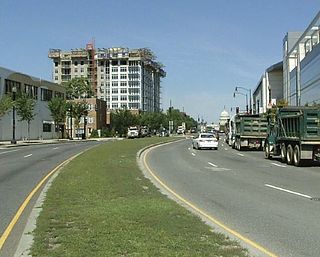
Congress Heights is a residential neighborhood in Southeast Washington, D.C., in the United States. The irregularly shaped neighborhood is bounded by the St. Elizabeths Hospital campus, Lebaum Street SE, 4th Street SE, and Newcomb Street SE on the northeast; Shepard Parkway and South Capitol Street on the west; Atlantic Street SE and 1st Street SE on the south; Oxon Run Parkway on the southeast; and Wheeler Street SE and Alabama Avenue SE on the east. Commercial development is heavy along Martin Luther King, Jr. Avenue and Malcolm X Avenue.

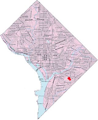
Neighborhoods in Washington, D.C., United States are distinguished by their history, culture, architecture, demographics, and geography. The names of 131 neighborhoods are unofficially defined by the D.C. Office of Planning. Neighborhoods can be defined by the boundaries of wards, historic districts, Advisory Neighborhood Commissions, civic associations, and business improvement districts (BIDs); these boundaries will overlap. The eight wards each elect a member to the Council of the District of Columbia and are redistricted every ten years.

The John Philip Sousa Bridge, also known as the Sousa Bridge and the Pennsylvania Avenue Bridge, is a continuous steel plate girder bridge that carries Pennsylvania Avenue SE across the Anacostia River in Washington, D.C., in the United States. The bridge is named for famous United States Marine Band conductor and composer John Philip Sousa, who grew up near the bridge's northwestern terminus.
South Capitol Street is a major street dividing the southeast and southwest quadrants of Washington, D.C., in the United States. It runs south from the United States Capitol to the D.C.–Maryland line, intersecting with Southern Avenue. After it enters Maryland, the street becomes Indian Head Highway at the Eastover Shopping Center, a terminal or transfer point of many bus routes.

Barney Circle is a small residential neighborhood located between the west bank of the Anacostia River and the eastern edge of Capitol Hill in southeast Washington, D.C., in the United States. The neighborhood is characterized by its sense of community, activism, walkability, and historic feel. The neighborhood's name derives from the eponymous former traffic circle Pennsylvania Avenue SE just before it crosses the John Philip Sousa Bridge over the Anacostia. The traffic circle is named for Commodore Joshua Barney, Commander of the Chesapeake Bay Flotilla in the War of 1812.

Fairlawn is a working class and middle class residential neighborhood in southeast Washington, D.C., United States. It is bounded by Interstate 295, Pennsylvania Avenue SE, Minnesota Avenue SE, Naylor Road SE, and Good Hope Road SE.

Fort Davis is a residential neighborhood located in southeast Washington, D.C., on the border between the District of Columbia and Maryland. It is bounded by Southern Avenue, Pennsylvania Avenue SE, and Alabama Avenue SE/Bowen Road SE.

Washington Highlands is a residential neighborhood in Southeast Washington, D.C., in the United States. It lies within Ward 8.

Good Hope is a residential neighborhood in southeast Washington, D.C., near Anacostia. The neighborhood is generally middle class and is dominated by single-family detached and semi-detached homes. The year-round Fort Dupont Ice Arena skating rink and the Smithsonian Institution's Anacostia Museum are nearby. Good Hope is bounded by Fort Stanton Park to the north, Alabama Avenue SE to the south, Naylor Road SE to the west, and Branch Avenue SE to the east. The proposed Skyland Shopping Center redevelopment project is within the boundaries of the neighborhood.

Greenway is a residential neighborhood in Southeast Washington, D.C., in the United States. The neighborhood is bounded by East Capitol Street to the north, Pennsylvania Avenue SE to the south, Interstate 295 to the west, and Minnesota Avenue to the east.

Naylor Gardens is a small neighborhood located in southeast Washington, D.C. It is bounded by Alabama Avenue SE, 30th Street SE, Erie Street SE, 32nd Street SE, Gainesville Street SE, 31st Street SE, and Naylor Road SE. The neighborhood is located in the area south and east of the Anacostia River.
Skyland is a neighborhood in Southeast Washington, D.C. It is bounded by Good Hope Road to the northeast, Alabama Avenue to the southeast, and Fort Stanton Park to the south and west. It is part of Ward 8. Also see article on the Anacostia neighborhood.

Randle Highlands is a neighborhood in Southeast Washington, D.C., east of the Anacostia River.

Penn Branch is a neighborhood in Southeast Washington, D.C., east of the Anacostia River. It is bounded by Pennsylvania Avenue SE to the south; Pope Branch Park and Pope Creek to the north; Branch Avenue to the west; and Fort Davis Park to the east. ‘Penn Branch’, takes its name from its location at the intersection of two major thoroughfares, Pennsylvania and Branch Avenue.

The Pennsylvania Avenue Line, designated Routes 32 and 36, is a daily Metrobus route in Washington, D.C., Operating between the Southern Avenue station or Naylor Road station of the Green Line of the Washington Metro and Potomac Park. Until the 1960s, it was a streetcar line, opened in 1862 by the Washington and Georgetown Railroad as the first line in the city.

Spring Garden is a neighborhood in central Philadelphia, Pennsylvania, United States, bordering Center City on the north. Spring Garden is a neighborhood that combines diverse residential neighborhoods and significant cultural attractions. The residential areas on the north side of the neighborhood are composed mostly of brick and brownstone three-story townhouses built during the mid-to-late 19th century. The houses include townhouses in the Italianate style, Second Empire, Queen Anne, and Venetian Gothic. Many streets include "terraced" set ups, which include a small gardened plot, often raised, in front of the house. The residential areas to the south are dominated by taller, multi-family buildings built during the 20th century. The museum area, also to the south of Spring Garden Street, includes the Rodin Museum, the Central Library of Philadelphia, and the Barnes Museum. Before consolidation of Philadelphia, Spring Garden was a district of Philadelphia County.

The Anacostia Historic District is a historic district in the city of Washington, D.C., comprising approximately 20 squares and about 550 buildings built between 1854 and 1930. The Anacostia Historic District was added to the National Register of Historic Places in 1978. "The architectural character of the Anacostia area is unique in Washington. Nowhere else in the District of Columbia does there exist such a collection of late-19th and early-20th century small-scale frame and brick working-class housing."
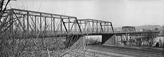
The Pennsylvania Avenue Bridge was a crossing of the Anacostia River in Washington, DC at the site of the present John Philip Sousa Bridge. It was constructed in 1890 and demolished around 1939.

