Brightwood (Washington, D.C.)

Last updated
Brightwood
Bank of Brightwood building (5155900534).jpg
Bank of Brightwood building
DC Neighborhoods - Brightwood.svg
Map of Washington, D.C., with Brightwood highlighted in red
Coordinates: 38°57′40″N77°01′39″W / 38.9612°N 77.0275°W / 38.9612; -77.0275
Country United States
District Washington, D.C.
WardWard 4
Government
  Councilmember Janeese Lewis George

Brightwood is a neighborhood in the northwestern quadrant of Washington, D.C. Brightwood is part of Ward 4.

Contents

Geography

Intersection of 14th St. and Tuckerman St. NW, Brightwood, February 2018 Brightwood DC.jpg
Intersection of 14th St. and Tuckerman St. NW, Brightwood, February 2018

The boundaries of Brightwood have varied over the years. In the mid-nineteenth century, the name generally encompassed the region north of Brightwood Park, west of Fort Totten, east of Rock Creek, and south of the Maryland line. [1] :89 Today, the Brightwood Community Association, an association of residents and business owners from the western part of Brightwood, define the neighborhood's boundaries as Walter Reed Army Medical Center and Aspen Street to the north, 16th Street and Rock Creek Park to the west, Georgia Avenue to the east, and Kennedy Street to the south. [2] Other widely accepted variations bound Brightwood on the east by 5th Street. [3] The DC Government's Citizens Atlas bounds the Brightwood Assessment Neighborhood to the south at Missouri Avenue. [4] Nearby neighborhoods include Shepherd Park and Takoma to the north, Manor Park to the east, and Sixteenth Street Heights and Petworth to the south. At the 2010 census, the neighborhood had 11,242 residents. [5]

Much of the retail stores in the neighborhood sit along Georgia Avenue. The neighborhood has no Metrorail stations, although the Takoma Metrorail station and Fort Totten Metro Station are within walking distance. Several Metrobus routes serve the community.

Brightwood is at an elevation of 292 feet (89 m). [6]

History

Early history

The land was part of a land patent called White Mill Seat in 1756. [7] The name was changed to Peter's Mill Seat in 1800. [7] Later, the area was called Crystal Springs, named after the pure water that flowed from several nearby springs. [7] One of the springs was located near the modern-day intersection of Fourteenth and Kennedy streets, [1] :98 which still flows in the present day, creating a constant stream of water on the sidewalk of the western side of Fourteenth Street, across from the Metrobus building. The area had many chestnut trees, and it was considered a place to enjoy with family. [8] The Passenger Railroad Company ran hourly stagecoaches from Fourteenth Street and Boundary Avenue to the springs, charging 25 cents per ride. [9]

The area was later known as Brighton, but residents decided to change the name to Brightwood in the 1840s [10] because the postal service frequently confused it with Brighton, Maryland. Archibald White and Louis Brunett are generally given credit for the new name. [1] :98

Transportation

Before 1889, Brightwood was so far outside the center city that the only transportation to it was a rickety horse-drawn cart driven by an African American man known by the name of Cherry. [11] Most of the land north of Rock Creek Church Road was farmland, although there were a few clusters of houses around Brightwood and Takoma Park. [11]

In 1899, the Brightwood Railway Company extended a streetcar line along Brightwood Avenue (now called Georgia Avenue) from Rock Creek Church Road to Brightwood. [11] The streetcar was only of some help to residents, as the streetcar line was famously unreliable. [11] The streetcar often came off its tracks, and passengers were asked to help push it back onto its tracks. [11] Some residents called it the G.O.P. (Get Out and Push) line. [11]

The Brightwood Citizens' Association was founded on March 17, 1891, the first neighborhood association founded anywhere in Northwest D.C. [11] James L. Norris was its first president. [11] The organization's initial purpose was to advocate for more reliable transportation to Brightwood. [11]

Emory United Methodist Church

Emory United Methodist Church Emory UMC DC 01.JPG
Emory United Methodist Church

Emory M.E. Church was built in 1832 when A.G. Pierce donated a half-acre of land in to build a church and a school. The original building stood two stories high: a first floor of logs for the school; and a second story of frame construction for worship, with a separate entrance from the outside. Black worshippers sat in a gallery. The church was named for John Emory of Queen Anne's County, Maryland, who had just been ordained bishop. Bishop Emory paid the $200 salary of the preacher's salary. In 1856, the 72-person congregation replaced the building with a red-brick structure that was torn down in 1861 for Union Army fortifications. A stone church was built in 1870. [1] :101 The present-day building, at 6100 Georgia Avenue NW, was erected in 1921. The churchyard was originally used as a cemetery, customary use of such land in those days. [1] :102 Some of the deceased were later moved to Rock Creek Cemetery. [1] :101

From the late 1970s to 1992, Emory's membership sharply declined, and the church was sold on almost two occasions. In 1992, Rev. Joseph W. Daniels Jr. came to Emory to serve as its part-time pastor. At the time, Emory's membership was 85 with an average worship size of 55 people. Under Daniels, average weekly attendance has grown from 55 people to more than over 400.[ citation needed ] The United Methodist Church organization has given Emory the "Kim Jefferson Northeast Jurisdictional Award" for effective urban ministry and designated it one of the 25 Congregational Resource Centers in the "Strengthening the Black Church for the 21st Century" effort.[ citation needed ]

Fort Stevens

Fort Stevens recreation Fort Stevens Park DC 04.JPG
Fort Stevens recreation

Brightwood is home to Fort Stevens, a Civil War fortification built by the Union Army as part of the defenses of Washington, D.C. The fort was built on the site of Emory Church, which was torn down and its bricks were used for the fort and baking ovens. A nearby log building used by the church was also torn down and its logs used to build a guardhouse for unruly soldiers. [1] :101 After Emory Church's congregation petitioned Congress for compensation for the torn-down church, Congress appropriated $412 for rent for use of the grounds. [1] :102

Fort Stevens was attacked by 20,000 Confederate soldiers led by General Jubal Early during the Battle of Fort Stevens on July 11 and July 12, 1864. [12] [13] The Union soldiers successfully repulsed the Confederate attack. [12]

Following petitions from veterans formerly stationed at the fort, [14] Congress established a park at the site and a memorial plaque. [1] :102

Forty soldiers are buried in the nearby historic Battleground National Cemetery. [15] An 1885 police census documented the population of Brightwood as 104. [16]

Brightwood Trotting Park

Brightwood was home to a horse racetrack originally named Crystal Springs Park, then Piney Branch Park, and finally Brightwood Trotting Park. [1] :98 [17] A tavern was nearby, operated by Frederick G. Rohr and later by his widow Annie M. Rohr. It was common for people to watch the races, swim in nearby Rock Creek, and have a picnic lunch. After many years, Brightwood Trotting Park greatly decreased in popularity. During its last year of operation, it was primarily used for racing mules. [1] :99 The course was closed in 1909 [18] in order to make way for the extension of Sixteenth Street. [19]

Other historic sites

Moreland's Tavern sat at the corner of modern-day Georgia and Missouri avenues before the Civil War. The building later became the Brightwood Club House, known for being a nice place to ride a horse and enjoy a drink. It eventually became the site of a Masonic Temple. [7]

Brightwood was also the location, in 1909, of the first successful flight by a helicopter in the United States, built by Emile Berliner. [20] His Gyro Motor Company building, which has been nominated for inclusion on the National Register of Historic Places, still stands at 770-774 Girard Street NW. [21]

The Sheridan Theater, a motion-picture theater, opened at 6217 Georgia Avenue NW in 1937. [22] The first feature was Sing Me A Love Song. [22]

Other historic sites include Engine Company 22 on Georgia Avenue NW, Fort View Apartments, which overlook the site of Fort Stevens and are listed on the National Register of Historic Places, and the Military Road School, which opened in 1864 and was one of the first schools in Washington to open after Congress authorized the education of African Americans. [23]

Redevelopment

The 21st century brought redevelopment of the commercial area along Georgia Avenue. [24]

Condominiums were completed at the corner of Georgia and Missouri Avenues in 2006. A restaurant, Meridian, operated on the first floor from January to June 2008, [25] reopened as Brightwood Bistro in August 2008, [26] and closed in 2012.

The corner of Georgia Avenue and Peabody Street was for years the site of the Curtis Chevrolet dealership and a car barn built in 1909. In 2007, Foulger-Pratt Development Inc., the company that redeveloped much of downtown Silver Spring, [27] filed plans to build a new building with 400 residential units (up to 8 percent of which would be reserved as affordable), restaurants, retail, and underground parking at the site. [27] [28] [29] [30] The D.C. Historical Preservation Society requested that Foulger-Pratt's design incorporate rather than demolish the car barn, [31] for which it planned to seek historical designation. [27] In response, Foulger-Pratt proposed to raze only the rear of the structure and renovate the front. [27] [32] Groundbreaking was anticipated in summer 2010 [32] but the plans fell through. In November 2010, Walmart announced interest in opening a store at the location by 2012. [33] [34] Some neighborhood residents opposed the plan, [35] but the company razed the entire site, including the car barn, in March 2012 and the store opened in December 2013. [36]

The Emory Beacon Center The Beacon Center.jpg
The Emory Beacon Center

The Beacon Center, a $55.3 million redevelopment surrounding the historic Emory United Methodist Church in Brightwood, opened in 2019. The project delivered 99 housing units: 91 reserved for tenants earning 60 percent or less than the area's median income, and eight for people leaving homelessness. [37]

Demographics

Immigrant communities

Brightwood has the highest percentage of immigrants of any neighborhood in D.C., with immigrants making up nearly 50 percent of the population. Brightwood also has the highest percentage of Ethiopians (16%) and Salvadorans (19%) of any neighborhood; [38] Salvadorans and Ethiopians are the two largest immigrant groups in Washington D.C. Brightwood's immigrant communities are mainly from Ethiopia, Eritrea, El Salvador and the rest of Central America, the Caribbean, and the Philippines. [39]

Related Research Articles

<span class="mw-page-title-main">Congress Heights</span> Neighborhood in Washington, D.C., U.S.

Congress Heights is a residential neighborhood in Southeast Washington, D.C., in the United States. The irregularly shaped neighborhood is bounded by the St. Elizabeths Hospital campus, Lebaum Street SE, 4th Street SE, and Newcomb Street SE on the northeast; Shepard Parkway and South Capitol Street on the west; Atlantic Street SE and 1st Street SE on the south; Oxon Run Parkway on the southeast; and Wheeler Street SE and Alabama Avenue SE on the east. Commercial development is heavy along Martin Luther King, Jr. Avenue and Malcolm X Avenue.

<span class="mw-page-title-main">Takoma (Washington, D.C.)</span> Neighborhood of Washington, D.C.

Takoma, Washington, D.C., is a neighborhood in Washington, D.C. It is located in Advisory Neighborhood Commission 4B, in the District's Fourth Ward, within the northwest quadrant. It borders the city of Takoma Park, Maryland.

<span class="mw-page-title-main">Petworth (Washington, D.C.)</span> Place

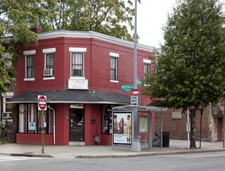
Petworth is a neighborhood of Washington, D.C., located in Northwest D.C. While largely residential, Petworth is home to a notable commercial corridor of shops and restaurants, primarily along Georgia Avenue and Upshur Street, as well as a portion of 14th Street. The neighborhood is accessible via the Georgia Ave–Petworth station on the Green Line of the Washington Metro.

<span class="mw-page-title-main">Streetcars in Washington, D.C.</span> Streetcars that existed in Washington until 1962

Streetcars in Washington, D.C. transported people across the city and region from 1862 until 1962.

<span class="mw-page-title-main">South Capitol Street</span>

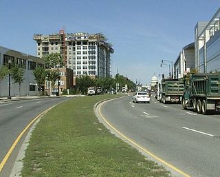
South Capitol Street is a major street dividing the southeast and southwest quadrants of Washington, D.C., in the United States. It runs south from the United States Capitol to the D.C.–Maryland line, intersecting with Southern Avenue. After it enters Maryland, the street becomes Indian Head Highway at the Eastover Shopping Center, a terminal or transfer point of many bus routes.

<span class="mw-page-title-main">Florida Avenue</span>

Florida Avenue is a major street in Washington, D.C. It was originally named Boundary Street, because it formed the northern boundary of the Federal City under the 1791 L'Enfant Plan. With the growth of the city beyond its original borders, Boundary Street was renamed Florida Avenue in 1890.

<span class="mw-page-title-main">Fort Totten (Washington, D.C.)</span> Place in the United States

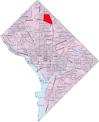
Fort Totten is a neighborhood located in Ward 5 of Northeast Washington, D.C.

<span class="mw-page-title-main">Georgia Avenue</span> Major north-south artery in NW Washington, DC, and Montgomery County, Maryland, US

Georgia Avenue is a major north-south artery in Northwest Washington, D.C., and Montgomery County, Maryland. In Washington, D.C., and for a short distance in Silver Spring, Maryland, Georgia Avenue is also U.S. Route 29. Howard University is located on Georgia Avenue.

<span class="mw-page-title-main">Park View (Washington, D.C.)</span> Neighborhood of Washington, D.C.

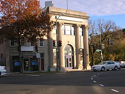
Park View is a neighborhood in Washington, D.C., located in Northwest D.C. The neighborhood is primarily residential with its main commercial corridor of shops and restauarants located along Georgia Avenue.

<span class="mw-page-title-main">Barney Circle</span> Neighborhood in the United States

Barney Circle is a small residential neighborhood located between the west bank of the Anacostia River and the eastern edge of Capitol Hill in southeast Washington, D.C., in the United States. The neighborhood is characterized by its sense of community, activism, walkability, and historic feel. The neighborhood's name derives from the eponymous former traffic circle Pennsylvania Avenue SE just before it crosses the John Philip Sousa Bridge over the Anacostia. The traffic circle is named for Commodore Joshua Barney, Commander of the Chesapeake Bay Flotilla in the War of 1812.

<span class="mw-page-title-main">Streetcars in Washington, D.C., and Maryland</span>

Streetcars and interurbans operated in the Maryland suburbs of Washington, D.C., between 1890 and 1962.

<span class="mw-page-title-main">Fairlawn (Washington, D.C.)</span> Neighborhood in Ward 8, United States

Fairlawn is a working class and middle class residential neighborhood in southeast Washington, D.C., United States. It is bounded by Interstate 295, Pennsylvania Avenue SE, Minnesota Avenue SE, Naylor Road SE, and Good Hope Road SE.

<span class="mw-page-title-main">Greenway (Washington, D.C.)</span> Neighborhood in Ward 7, United States

Greenway is a residential neighborhood in Southeast Washington, D.C., in the United States. The neighborhood is bounded by East Capitol Street to the north, Pennsylvania Avenue SE to the south, Interstate 295 to the west, and Minnesota Avenue to the east.

<span class="mw-page-title-main">Manor Park (Washington, D.C.)</span>

Manor Park is a neighborhood in Ward 4 of northwest Washington, D.C.

<span class="mw-page-title-main">Brightwood Park</span> Place in the United States

Brightwood Park is a small neighborhood in Northwest Washington, D.C. in the United States. The neighborhood is bounded by Georgia Avenue NW to the west, Missouri Avenue NW to the northeast and Kennedy Street NW to the south. More recently, areas that are technically part of the northern extremity of the Petworth neighborhood have been increasingly referred to as Brightwood Park. Often these informal boundaries extend south to Emerson Street NW, and east to New Hampshire Avenue NW. Another definition places Hamilton Street NW as Brightwood Park's southern boundary. Yet another definition places Brightwood Park's southern boundary as Ingraham Street NW. The most expansive definition state Brightwood Park's borders as Missouri Avenue to the north, North Capitol Street on the east, Emerson Street to the south and Georgia Avenue on the west. It is located in Ward 4.

<span class="mw-page-title-main">Sixteenth Street Heights</span>

Sixteenth Street Heights is a large neighborhood of rowhouses, duplexes, and American Craftsman and American Foursquare detached houses in Northwest Washington, D.C.

<span class="mw-page-title-main">Metropolitan Railroad</span>

The Metropolitan Railroad was the second streetcar company to operate in Washington, D.C., the capital city of the United States. It was incorporated and started operations in 1864, running from the Capitol to the War Department and along H Street NW in downtown. It added lines on 9th Street NW, on 4th Street SW/SE, along Connecticut Avenue to Dupont Circle, to Georgetown, to Mount Pleasant and north along Georgia Avenue. In the late 19th century, it was purchased by the Washington Traction and Electric Company and on February 4, 1902, became a part of the Washington Railway and Electric Company.

Fort Stevens Ridge is a neighborhood in Northwest Washington, D.C. built during the 1920s. The neighborhood comprises about 50 acres (0.20 km2) and is very roughly bounded by Peabody Street, Fifth Street, Underwood Street, and Ninth Street. As of the 2010 census, the neighborhood had 2,597 residents. It was named for nearby Fort Stevens, a Civil War-era fort used to defend the nation's capital from invasion by Confederate soldiers.

<span class="mw-page-title-main">Outline of Washington, D.C.</span> Overview of and topical guide to District of Columbia

The following outline is provided as an overview of and topical guide to the District of Columbia:

<span class="mw-page-title-main">Georgia Avenue–7th Street Line</span>

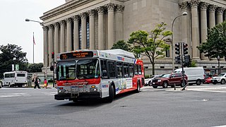
The Georgia Avenue–7th Street Line, designated as Route 70, is a daily bus route that is operated by the Washington Metropolitan Area Transit Authority between Silver Spring station of the Red Line of the Washington Metro and Archives station of the Green and Yellow lines of the Washington Metro. With late night and early morning trips extending to L'Enfant Plaza station of the Blue, Orange, Silver, Green and Yellow Lines of the Washington Metro. The line operates every 12 minutes during the weekdays, 15 minutes during the weekends, and 20 minutes during the late nights. Trips are roughly 60 minutes.

References

  1. 1 2 3 4 5 6 7 8 9 10 11 Proctor, John Clagett (1949). Proctor's Washington and Environs. John Clagett Proctor.
  2. "About BCA" Archived 2008-05-09 at the Wayback Machine . Brightwood Community Association. Retrieved January 18, 2008.
  3. "Brightwood" Archived May 27, 2009, at the Wayback Machine . Cultural Tourism DC. Retrieved August 15, 2009.
  4. "DC Citizens Atlas". Archived from the original on 13 December 2012. Retrieved 19 March 2012.
  5. "District of Columbia - New Ward 4 2010 Total Population by Census Block by Ward, ANC and SMD Boundaries" (PDF). Office of Planning. Government of the District of Columbia. July 1, 2011. Archived from the original (PDF) on October 6, 2012. Retrieved September 10, 2011.
  6. Rand McNally Commercial Atlas & Marketing Guide. Vol. 2 (141 ed.). Rand McNally. 2010. p. 47.
  7. 1 2 3 4 Proctor, John Clagett (February 13, 1938). "Reservoir Razed: Brightwood Landmark Doomed as New Recreation Center is Created on Site—Horse Race History". Washington Evening Star. p. 30.
  8. "Crystal Springs" (classified advertisement). Washington Evening Star. July 3, 1860. p. 2.
  9. Ferguson, B. (June 24, 1863). "Coaches for Crystal Spring" (classified advertisement). Washington Evening Star. p. 3.
  10. Proctor, John Clagett, ed. (1930). Washington Past and Present. New York: Lewis Historical Publishing Company, Inc. p. 146.
  11. 1 2 3 4 5 6 7 8 9 Proctor, John Clagett (January 1, 1922). "Brightwood Proud of 30-Year Fight for Civic Improvement". Washington Herald. Retrieved 2024-07-21.
  12. 1 2 "The Invasion". Washington Evening Star. July 12, 1964. p. 2.
  13. "The Charge on the Rebels Last Night: They Are Driven a Mile and a Half". Washington Evening Star. July 13, 1864. p. 2.
  14. "For Park at Fort Stevens". The Washington Post. December 21, 1906. p. 13. ProQuest   144706560.
  15. "For Fort Stevens' Dead". The Washington Post. May 31, 1907. p. 2. ProQuest   144801372.
  16. Proctor, John Clagett, ed. (1930). Washington Past and Present. New York: Lewis Historical Publishing Company Inc. p. 157.
  17. "Racing Near Washington" (PDF). The New York Times. November 18, 1876.
  18. Schofield, Carl (December 19, 1909). "Historic Race Course Gone". The Sunday Chronicle. Paterson, New Jersey. p. 14.
  19. "Passing of Brightwood Park". The Washington Post. October 7, 1909. p. 6. ProQuest   144907370.
  20. "Helicoptre Lifts Itself and Man". The Youngstown Daily Vindicator. July 1, 1909. p. 14.
  21. "National Register of Historic Places Registration Form (Standard Material Company/Gyro Motor Company)". National Park Service. 2022-11-28. Archived from the original on 28 Nov 2022. Retrieved 2023-02-09.
  22. 1 2 "Warner Bros. New Sheridan Theater Opens Tonight." The Washington Times. January 14, 1937. p. 33.
  23. "Military Road School, African American Heritage Trail". Cultural Tourism DC. Archived from the original on 2012-05-12. Retrieved 2011-11-09.
  24. "Upper Georgia Avenue Land Development Plan" Archived March 27, 2008, at the Wayback Machine . District of Columbia Office of Planning. Retrieved January 18, 2008.
  25. McCart, Melissa. "Busy Georgia Ave. Corner Gets Restaurant Anchor". Express. January 9, 2008.
  26. Frederick, Missy. "Brightwood Bistro takes over former Meridian site". Washington Business Journal. September 12, 2008. Retrieved September 15, 2008.
  27. 1 2 3 4 O'Connell, Jonathan. "Foulger-Pratt to save part of historic D.C. car barn". Washington Business Journal. August 11, 2008. Retrieved October 1, 2008.
  28. Schwartzman, Paul. "Deal Close on Georgia Ave. Dealership Site". The Washington Post. January 12, 2008.
  29. O'Connell, Jonathan. "Foulger-Pratt to Turn Georgia Ave. Car Lot into New Mixed-use Project". Washington Business Journal. November 30, 2007.
  30. O'Connell, Jonathan. "Neighborhood TIF comes to Georgia Ave. corridor". Washington Business Journal. December 7, 2007. Retrieved October 1, 2008.
  31. Moore, Wayetu. "Historical Society Scrutinizing Plans for High-Rise on Former Car Lot in Brightwood" Archived 2008-06-17 at the Wayback Machine . Black College View. April 6, 2008.
  32. 1 2 "Curtis Chevrolet Site: Application for Large tract Review Approval: Statement in Support" (PDF). Missouri Avenue Development Partners LLC. District of Columbia Office of Planning. Archived from the original (PDF) on 2009-02-27.
  33. O'Connell, Jonathan; DeBonis, Mike (November 18, 2010). "Wal-Mart plans to open 4 stores in the District". The Washington Post.{{cite news}}: CS1 maint: multiple names: authors list (link)
  34. Frederick, Missy (November 18, 2010). "Wal-Mart is coming to D.C. Now what?". Washington Business Journal.
  35. O'Connell, Jonathan (December 16, 2010). "Activists wage campaign against Wal-Mart in D.C." The Washington Post.
  36. Mollet, Melissa; DiMargo, Carissa (December 4, 2013). "Walmart opens first DC Stores". NBC4 Washington. Retrieved February 17, 2019.
  37. Austermuhle, Martin (October 12, 2016). "The Battle For Fort Stevens: How Civil War Buffs And A Church Fought Over Housing". WAMU. Retrieved 12 December 2020.
  38. "The Demographic Statistical Atlas of the United States - Statistical Atlas". statisticalatlas.com. Retrieved 2021-09-15.
  39. "The Demographic Statistical Atlas of the United States - Statistical Atlas". statisticalatlas.com. Retrieved 2021-09-15.