Friendship Heights

Last updated
Friendship Heights
Wisconsin Avenue in Friendship Heights.jpg
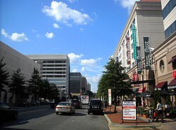
Facing north on Wisconsin Avenue in Friendship Heights
DC Neighborhoods - Friendship Heights.svg
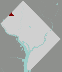
Map of Washington, D.C., with Friendship Heights highlighted in red
Coordinates: 38°57′25″N77°05′02″W / 38.957°N 77.083778°W / 38.957; -77.083778
Country United States
District Washington, D.C.
WardWard 3
Government
  Councilmember Mary Cheh

Friendship Heights is an urban commercial and residential neighborhood in northwest Washington, D.C., and southern Montgomery County, Maryland. Though its borders are not clearly defined, Friendship Heights consists roughly of the neighborhoods and commercial areas around Wisconsin Avenue north of Fessenden Street NW and Tenleytown to Somerset Terrace and Willard Avenue in Maryland, and from River Road in the west to Reno Road and 41st Street in the east. Within Maryland west of Wisconsin Avenue is the Village of Friendship Heights, technically a special taxation district.

Contents

The portion in the District of Columbia lies in Ward 3, represented by ANCs 3E03 and 3E04. It is often considered to be part of Chevy Chase, D.C.; The most substantial commercial aspects are the shopping plazas near the intersection of Wisconsin and Western Avenues. Found here are many department stores, as well as numerous boutiques, day spas, a multiplex cinema and other services which cater to the residents as well as visitors to the area. The area also features a variety of moderate and discount chains.

The neighborhood also supports a number of offices, including the corporate headquarters of insurance giant GEICO (originally Government Employees Insurance Company) and the Ritz-Carlton hotel chain, and a concentration of broadcast media including the studios of WMAL-FM and WTOP-FM. As a result, heavy traffic is not uncommon.

The Friendship Heights Station on the Red Line of the Washington Metro system serves the area, and the station is also a major connecting depot for area bus services. Streetcar service, which once connected the neighborhood to Georgetown, was abandoned in 1960.

Since the late 1990s, development has accelerated in the neighborhood, notably the construction of Chase Tower on Willard Avenue, a new Chevy Chase Center replacing the older 1980s-era complex of the same name, and new condominiums on the site of the former Washington Women's Clinic.

Retail

For decades, a six-block stretch of Wisconsin Avenue in Friendship Heights and Chevy Chase contained the only concentration of traditional department stores at least partially in Washington, D.C. Two of these closed in 2020: the Lord & Taylor and Neiman Marcus stores, both of which were in D.C. [1] As of 2022, two department stores remain, both on the Maryland side: a freestanding Saks Fifth Avenue and a Bloomingdale's in Wisconsin Place, which also includes a Whole Foods Market, boutiques, and residential and office space.

The D.C. portion of the stretch includes these shopping centers:

On the Maryland side is The Collection at Chevy Chase, an upscale center that includes a Tiffany & Co. location.

Education

District of Columbia Public Schools operates public schools. Friendship Heights is served by Janney Elementary School, Alice Deal Middle School, and Jackson-Reed High School. [3]

The Maryland side of Friendship Heights is served by Somerset Elementary School, Westland Middle School, and Bethesda Chevy Chase High School.

District of Columbia Public Library operates the Tenley-Friendship Library. [4] After seven years in an interim location, the library reopened in 2011 at the corner of Wisconsin Avenue and Albemarle Streets. [5]

See also

Related Research Articles

<span class="mw-page-title-main">Kensington, Maryland</span> Town in Maryland, United States

Kensington is a town in Montgomery County, Maryland, United States. The population was 2,122 at the 2020 census. Greater Kensington encompasses the entire 20895 ZIP code, with a population of 19,753 in 2020.

<span class="mw-page-title-main">Friendship Heights Village, Maryland</span> Census-designated place in Maryland, United States

Friendship Heights Village is an urbanized, unincorporated area in Montgomery County, Maryland, United States. It is distinct from the Washington, D.C., neighborhood of Friendship Heights). Friendship Heights Village is a census-designated place (CDP), with a population of 5,360 at the 2020 census.

<span class="mw-page-title-main">Chevy Chase, Maryland</span> Unincorporated community in Maryland, United States

Chevy Chase is the name of both a town and an unincorporated census-designated place that straddle the northwest border of Washington, D.C., and Montgomery County, Maryland, United States. Several settlements in the same area of Montgomery County and one neighborhood of Washington include Chevy Chase in their names. These villages, the town, and the CDP share a common history and together form a larger community colloquially referred to as Chevy Chase.

<span class="mw-page-title-main">Friendship Heights station</span> Washington Metro station

Friendship Heights station is a Washington Metro station straddling the border of Washington, D.C., and Montgomery County, Maryland, United States. The station was opened on August 25, 1984, and is operated by the Washington Metropolitan Area Transit Authority (WMATA).

<span class="mw-page-title-main">Bethesda station</span> Washington Metro station

Bethesda station is a rapid transit station on the Red Line of the Washington Metro system in Bethesda, Maryland. It is one of the busiest suburban Metro stations, serving on average 9,142 passengers each weekday in 2017. The Purple Line, a light rail system currently under construction, will terminate at Bethesda, providing rail service to other inner Maryland suburbs such as Silver Spring and College Park, each of which has additional north-south connections by Washington Metro, and New Carrollton, which has Amtrak and MARC connections to both Washington, D.C., and Baltimore.

<span class="mw-page-title-main">Tenleytown</span> Place in the United States

Tenleytown is a historic neighborhood in Northwest, Washington, D.C.

<span class="mw-page-title-main">Northwest (Washington, D.C.)</span> Quadrant in the United States

Northwest is the northwestern quadrant of Washington, D.C., the capital of the United States, and is located north of the National Mall and west of North Capitol Street. It is the largest of the four quadrants of the city, and it includes the central business district, the Federal Triangle, and the museums along the northern side of the National Mall, as well as many of the District's historic neighborhoods.

<span class="mw-page-title-main">Columbia Heights (Washington, D.C.)</span> Neighborhood of Washington, D.C.

Columbia Heights is a neighborhood in Washington, D.C., located in Northwest D.C. It has diverse demographics, the DC USA shopping mall and many restaurants, BloomBars, Meridian Hill/Malcolm X Park, Howard University, Banneker Recreation Center, and All Souls Church.

<span class="mw-page-title-main">Cleveland Park</span> Neighborhood in Washington, D.C.

Cleveland Park is a residential neighborhood in the Northwest quadrant of Washington, D.C. It is located at 38°56′11″N77°3′58″W and bounded approximately by Rock Creek Park to the east, Wisconsin and Idaho Avenues to the west, Klingle and Woodley Roads to the south, and Rodman and Tilden Streets to the north. Its main commercial corridor lies along Connecticut Avenue NW, where the eponymous Cleveland Park station of the Washington Metro's Red Line can be found; another commercial corridor lies along Wisconsin Avenue. The neighborhood is known for its many late 19th century homes and the historic Art Deco Uptown Theater. It is also home to the William L. Slayton House and the Park and Shop, built in 1930 and one of the earliest strip malls.

<span class="mw-page-title-main">Chevy Chase (Washington, D.C.)</span> Place in the United States

Chevy Chase is a neighborhood in northwest Washington, D.C. It borders Chevy Chase, Maryland, a collection of similarly affluent neighborhoods.

<span class="mw-page-title-main">Connecticut Avenue</span> Thoroughfare in Washington, D.C., and Maryland

Connecticut Avenue is a major thoroughfare in the Northwest quadrant of Washington, D.C., and suburban Montgomery County, Maryland. It is one of the diagonal avenues radiating from the White House, and the segment south of Florida Avenue was one of the original streets in Pierre (Peter) Charles L'Enfant's plan for Washington. A five-mile segment north of Rock Creek was built in the 1890s by a real-estate developer.

<span class="mw-page-title-main">Streetcars in Washington, D.C., and Maryland</span>

Streetcars and interurbans operated in the Maryland suburbs of Washington, D.C., between 1890 and 1962. Lines in Maryland were established as separate legal entities, but eventually they were all owned or leased by DC Transit. Unlike the Virginia lines, the Washington and Maryland lines were scheduled as a single system. Most of the streetcar lines were built with grand plans in mind, but none succeeded financially. A combination of the rise of the automobile, various economic downturns and bustitution eventually spelled the end of streetcars in southern Maryland.

<span class="mw-page-title-main">The Collection at Chevy Chase</span> Shopping mall in Chevy Chase, Maryland

The Collection is a set of shops and restaurants near the Friendship Heights Metro station on Wisconsin Avenue in Chevy Chase, Maryland, along the Washington, D.C.-Maryland border. The shopping center was developed by the Chevy Chase Land Company, a privately owned development corporation that has owned the land for more than a century.

<span class="mw-page-title-main">Mazza Gallerie</span> Shopping mall in D.C., United States

Mazza Gallerie was an upscale shopping mall in the Friendship Heights neighborhood of northwest Washington, D.C. Opened in 1977, it had 300,000 square feet (28,000 m2) of retail space on three levels, a parking garage, and a direct connection to the Friendship Heights station of the Washington Metro. The last retail business closed in December 2022. The building is to be converted to residential apartments with retail on the ground floor.

Fairfax Square is an upscale mixed-use development located directly south of Tysons Corner Center across Leesburg Pike in Tysons Corner, Virginia. It includes 400,000 sq ft (37,160 m2) of Class A office space, primarily occupied by financial tenants such as American Express, Merrill Lynch, and New York Life, and high-end ground-floor retail among its three identical high-rises. Fairfax Square was designed by Skidmore, Owings & Merrill. Its buildings are clad in Brazilian granite, and its lobbies are finished with Italian marble and wood paneling. Ground was broken for the development in 1988. The complex replaced a KMart store and its parking lot.

<span class="mw-page-title-main">Outline of Washington, D.C.</span> Overview of and topical guide to District of Columbia

The following outline is provided as an overview of and topical guide to District of Columbia:

<span class="mw-page-title-main">Garden Club of America Entrance Markers in Washington, D.C.</span> United States historic place

The Garden Club of America Entrance Markers in Washington, D.C. is a Multiple Property Submission, or MPS, on the National Register of Historic Places. The seven structures that make up the MPS are ceremonial markers at important entrance points to the District of Columbia from the state of Maryland. Sets of two markers are located in Westmoreland Circle, Friendship Heights and Chevy Chase Circle. A single marker is located along Georgia Avenue.

<span class="mw-page-title-main">Western Avenue (Washington, D.C.)</span>

Western Avenue is one of three boundary streets between Washington, D.C., and the state of Maryland. It follows a southwest-to-northeast line, beginning at Westmoreland Circle in the south and ending at Oregon Avenue NW in the north. It is roughly 3.5 miles (5.6 km) in length. First proposed in 1893, it was constructed somewhat fitfully from about 1900 to 1931.

<span class="mw-page-title-main">Belmont (Chevy Chase, Maryland Subdivision)</span> Undeveloped neighborhood for African Americans in Chevy Chase, Maryland, U.S.

The Belmont property was a subdivided strip of land on the eastern side of Chevy Chase, Maryland, along Wisconsin Avenue. In 1906, a group of African American investors acquired the parcel and sold lots to other African Americans, in an effort to develop a high-end suburb for D.C.'s sizable Black middle class. Had the project succeeded, it would have been one of the earliest modern suburbs developed for African Americans.

<span class="mw-page-title-main">The Chevy Chase Land Company</span> American real estate company

The Chevy Chase Land Company is a real estate holding and development company based in suburban Washington, D.C.

References

  1. https://planning.dc.gov/sites/default/files/dc/sites/op/publication/attachments/Friendship%2520Heights.draft%2520final.pdf
  2. https://www.popville.com/2020/12/friendship-heights-is-looking-more-and-more-bare/
  3. "D.C.'s new school boundaries for 2015 - Washington Post".
  4. "Hours & Locations." District of Columbia Public Library. Retrieved on October 21, 2009.
  5. "Hours & Locations." District of Columbia Public Library. Retrieved on October 21, 2009.