Forest Glen is a census-designated place (CDP) in Montgomery County, Maryland, United States. Its population was 6,897 as of the 2020 census.

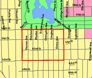
Kemp Mill is a census-designated place and an unincorporated census area in Montgomery County, Maryland, United States. The population was 13,378 at the 2020 census.

Mount Pleasant is a neighborhood in the northwestern quadrant of Washington, D.C. It is bounded by Rock Creek Park to the north and west; Harvard Street NW to the south; and 16th Street NW to the east. It is north of Adams Morgan and west of Columbia Heights. It is home to about 10,000 people.

Columbia Heights is a neighborhood in Washington, D.C., located in Northwest D.C. It has diverse demographics, the DC USA shopping mall and many restaurants, BloomBars, Meridian Hill/Malcolm X Park, Howard University, Banneker Recreation Center, and All Souls Church.

Shaw is a neighborhood of Washington, D.C., located in the Northwest quadrant. Shaw is a major entertainment and retail hub, and much of the neighborhood is designated as a historic district, including the smaller Blagden Alley-Naylor Court Historic District. Shaw and the U Street Corridor have historically have been the city's hub for African-American social, cultural, and economic life.

Shepherd Park is a neighborhood in the northwest quadrant of Washington, D.C. In the years following World War II, restrictive covenants which had prevented Jews and African Americans from purchasing homes in the neighborhood were no longer enforced, and the neighborhood became largely Jewish and African American. Over the past 40 years, the Jewish population of the neighborhood has declined but the neighborhood has continued to support a thriving upper and middle class African American community. The Shepherd Park Citizens Association and Neighbors Inc. led efforts to stem white flight from the neighborhood in the 1960s and 1970s, and it has remained a continuously integrated neighborhood, with very active and inclusive civic groups.
The Central Area, commonly called the Central District or The CD, is a mostly residential district in Seattle located east of downtown and First Hill ; west of Madrona, Leschi and Mt. Baker; south of Capitol Hill, and north of Rainier Valley. Historically, the Central District has been one of Seattle's most racially and ethnically diverse neighborhoods, and was once the center of Seattle's black community and a major hub of African-American businesses.

Madrona is a mostly residential neighborhood in east Seattle, Washington. It is bounded on the east by Lake Washington; on the south by E. Cherry Street, beyond which is Leschi; on the west by Martin Luther King Jr. Way, beyond which is the Central District; and on the north by E. Howell Street, beyond which is Denny-Blaine.

The Rainier Valley is a district in southeast Seattle. It is located east of Beacon Hill; west of Mount Baker, Seward Park, and Leschi; south of the Central District and north of Rainier Beach. It is part of Seattle's South End.
Bloomingdale is a neighborhood in the Northwest quadrant of Washington, D.C., less than two miles (3 km) north of the United States Capitol building. It is a primarily residential neighborhood, with a small commercial center near the intersection of Rhode Island Avenue and First Street NW featuring bars, restaurants, and food markets.

Woodside Park is a neighborhood located in Silver Spring, Maryland, in the United States.

Riggs Park, also known as "Lamond Riggs", is a residential neighborhood in Ward 4 of Northeast Washington, D.C. Riggs Park is contained between Eastern Avenue N.E. to the east, Riggs Road N.E. to the south, North Capitol Street N.W. to the north and west, and the Blair Road Community Garden to the north. Riggs Park is adjacent to the neighborhoods of Queens Chapel, North Michigan Park, and Fort Totten, located in Ward 5 of Northeast Washington D.C. In addition to these neighborhoods, Riggs Park also borders the city/neighborhood Chillum, which is located in Prince George's County, Maryland. The WMATA Red Line train tracks pass through the Riggs Park neighborhood when traveling between the Takoma and Fort Totten Metro Stations. In addition to the WMATA Red Line, the CSX, MARC, and Amtrak train tracks, pass through the Riggs Park neighborhood as well.

Colonial Village is an area in northwest Washington, D.C., built in 1931 with 80 residences. The homes are reproductions of colonial buildings, such as the Moore House, where General Charles Cornwallis surrendered at Yorktown. The community was mostly Protestant, in contrast to the nearby 220-house North Portal Estates, which was a mostly Jewish neighborhood. When the community was first constructed in 1931, the neighborhood was exclusively populated by white Protestants as black and Jewish people were prohibited from living in Colonial Village. The land on which Colonial Village lies on, was once the 145 acre plantation of slaveowner Phillip Fenwick. After the mid-20th century, both Colonial Village and North Portal Estates became part of Shepherd Park.
The neighborhoods of Omaha are a diverse collection of community areas and specific enclaves. They are spread throughout the Omaha metro area, and are all on the Nebraska side of the Missouri River.
The Washington Park Court District is a Grand Boulevard community area neighborhood on the South Side of Chicago, Illinois. It was designated a Chicago Landmark on October 2, 1991. Despite its name, it is not located within either the Washington Park community area or the Washington Park park, but is one block north of both. The district was named for the Park.

The Strivers' Section Historic District is a historic district located in the Dupont Circle neighborhood of Washington, D.C. Strivers' Section was historically an enclave of upper-middle-class African Americans, often community leaders, in the late 19th and early 20th centuries. It takes its name from a turn-of-the-20th-century writer who described the district as "the Striver's section, a community of Negro aristocracy." The name echoes that of Strivers' Row in Harlem, a New York City historic neighborhood of black professionals. The district is roughly bounded by Swann Street and the Dupont Circle Historic District on the south, Florida Avenue and the Washington Heights Historic District on the north and west, and the Sixteenth Street Historic District on the east.
Woodmoor is a neighborhood in the northern section of Silver Spring, Maryland in southeastern Montgomery County, in the U.S. state of Maryland. Its borders extend from U.S. 29 to the west, Northwest Branch Park to the north, the Capital Beltway (I-95) to the east, and University Boulevard to the south. It lies on one of the "Four Corners" at the northeastern corner of the intersection of Colesville Road, and University Boulevard.

Franklin Knolls is a residential neighborhood located in Silver Spring, a census-designated place in Montgomery County.
Rock Creek Forest is a mostly residential neighborhood in Silver Spring / Chevy Chase, Maryland. It is bordered by Chevy Chase to the east, Silver Spring to the west, Maryland Route 410 to the north, and the border with Washington, D.C., to the south. The historically African-American neighborhood of Lyttonsville is to the north, while Rock Creek Park and the neighborhoods of North Portal Estates / Colonial Village / Shepherd Park are to the south.