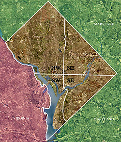
Color-enhanced USGS satellite image of Washington, D.C., taken April 26, 2002. The "crosshairs" in the image mark the quadrant divisions of Washington, with the United States Capitol at the center of the dividing lines. To the west of the Capitol extends the National Mall, visible as a slight green band in the image. The Northwest quadrant is the largest, located north of the Mall and west of North Capitol Street.
Washington, D.C., is administratively divided into four geographical quadrants of unequal size, each delineated by their ordinal directions from the medallion located in the Crypt under the Rotunda of the Capitol. Street and number addressing, centered on the Capitol, radiates out into each of the quadrants, producing a number of intersections of identically named cross-streets in each quadrant.[clarification needed] Originally, the District of Columbia was a near-perfect square but contained more than one settlement; the Capitol was to be the center of the City of Washington. Thus, the Capitol was never located at the geographic center of the whole territory, which was eventually north of the Potomac River, consolidated into one city. (The geographic center was located near the onetime marshy area of the present-day intersection of 17th Street, NW and Constitution Ave.) As a result, the quadrants are of greatly varying size. Northwest is quite large, encompassing over a third of the city's geographical area, while Southwest is little more than a few neighborhoods, large parks, and a military base.
The boundaries of the quadrants are not necessarily straight lines radiating from the medallion, but in three instances follow the paths of the boundary streets (which in some cases curve around topographical features): North Capitol Street, South Capitol Street, and East Capitol Street. The axis of the National Mall through the Washington Monument and the Lincoln Memorial forms the boundary running west of the medallion.
"Southwest" (SW or S.W.) is located south of the National Mall and west of South Capitol Street and is the smallest quadrant of the city. Although roughly half of the quadrant is located south of the Anacostia River in Anacostia, references to "Southwest" generally allude to the area near downtown, within about a mile of the Capitol, much of which was demolished and redeveloped in the 1960s with modern federal office and apartment buildings. Fort McNair and the National War College are also there. The section south of the river, except for the Bellevue neighborhood, is almost entirely devoted to Joint Base Anacostia-Bolling, the U.S. Naval Research Laboratory, and the Blue Plains Advanced Wastewater Treatment Plant.
This page is based on this Wikipedia article Text is available under the CC BY-SA 4.0 license; additional terms may apply. Images, videos and audio are available under their respective licenses.