Southeast (Washington, D.C.)

Last updated

Southeast
Quadrant
DC satellite image.jpg
Color-enhanced USGS satellite image of Washington, D.C., taken April 26, 2002. The "crosshairs" in the image mark the quadrant divisions of Washington, with the U.S. Capitol at the center of the dividing lines. To the west of the Capitol extends the National Mall, visible as a thin green band in the image. The Northwest quadrant is the largest, located north of the Mall and west of North Capitol Street.
Country Flag of the United States.svg United States
DistrictFlag of the District of Columbia.svg  Washington, D.C.

Southeast (SE or S.E.) is the southeastern quadrant of Washington, D.C., the capital of the United States, and is located south of East Capitol Street and east of South Capitol Street. It includes the Capitol Hill and Anacostia neighborhoods, the Navy Yard, the Joint Base Anacostia-Bolling (JBAB), the U.S. Marine Barracks, the Anacostia River waterfront, Eastern Market, the remains of several Civil War-era forts, historic St. Elizabeths Hospital, RFK Stadium, Nationals Park, and the Congressional Cemetery. It also contains a landmark known as "The Big Chair," located on Martin Luther King Jr. Avenue. [1] The quadrant is split by the Anacostia River, with the portion that is west of the river sometimes referred to as "Near Southeast". Geographically, it is the second-smallest quadrant of the city.

Contents

Southeast (Washington DC) The Yards Park at the Antacostia River Front SEDCanacostia.jpg
Southeast (Washington DC) The Yards Park at the Antacostia River Front
Southeast (Washington DC) Nationals Park Looking Northwest SEDCnats.jpg
Southeast (Washington DC) Nationals Park Looking Northwest
Southeast (Washington DC) RFK Stadium SEDCrfk.jpg
Southeast (Washington DC) RFK Stadium
Southeast (Washington DC) South Capitol St & Solar Panel Farm SEDCsolar.jpg
Southeast (Washington DC) South Capitol St & Solar Panel Farm

Geography

Southeast includes the 32 neighborhoods of:

Government

Politically, Southeast includes most of Ward 8, as well as much of Ward 6 and Ward 7. Marion Barry, the former mayor of Washington, D.C., served as D.C. Council Member for Ward 8 until his death on November 23, 2014. [2] [3]

Culture

Nationals Park, the current ballpark for Major League Baseball's Washington Nationals, opened in Southeast in March 2008. [4]

Transportation

Southeast Washington, D.C. is accessible via the Blue, Orange, Green and Silver Lines of the Washington Metro. [5]

Crime

In years past, the quadrant was known by some Washington, D.C. metropolitan area residents as being plagued by a high crime rate, relative to the rest of the city. [6]

Demographics

The population of Southeast is predominantly black. However, the African American population is concentrated southeast of the Anacostia River; the areas northwest of the Anacostia River are majority White. The portions of the quadrant southeast of the Anacostia are tree-lined and neighborly. However, shopping, dining, entertainment, and cultural options are limited, so some residents travel either downtown or to the suburbs for such services. There are several black middle class neighborhoods in Southeast, such as Hillcrest, Penn Branch, and Fort Dupont. The areas northwest of the Anacostia contain some of the wealthiest parts of the city, including the southern half of the famous and politically connected Capitol Hill neighborhood. Cultural events/activities include the annual Martin Luther King Jr. Birthday parade, the free weekly summer jazz concerts in Fort Dupont Park, the Fort Dupont ice-rink, the Anacostia Museum of the Smithsonian Institution, the Anacostia Arts Center, and THEARC tennis, arts and learning center for youth on Mississippi Avenue. The population of the southeast quadrant is roughly 226,084. [7]

Aerial view looking East, of the Anacostia River and SE Washington, D.C. SEWashingtonDC-0085-122122.jpg
Aerial view looking East, of the Anacostia River and SE Washington, D.C.
SE Washington, D.C.; Anacostia River From Buzzard Point to the Navy Yard SEWashingtonDC-9808-120719.jpg
SE Washington, D.C.; Anacostia River From Buzzard Point to the Navy Yard

See also

Related Research Articles

<span class="mw-page-title-main">Anacostia</span> Neighborhood in Washington, D.C.

Anacostia is a historic neighborhood in Southeast Washington, D.C. Its downtown is located at the intersection of Good Hope Road and Martin Luther King Jr. Avenue. It is located east of the Anacostia River, after which the neighborhood is named.

<span class="mw-page-title-main">Northwest (Washington, D.C.)</span> Quadrant in the United States

Northwest is the northwestern quadrant of Washington, D.C., the capital of the United States, and is located north of the National Mall and west of North Capitol Street. It is the largest of the four quadrants of the city, and it includes the central business district, the Federal Triangle, and the museums along the northern side of the National Mall, as well as many of the District's historic neighborhoods.

<span class="mw-page-title-main">Northeast (Washington, D.C.)</span> Quadrant in the United States

Northeast is the northeastern quadrant of Washington, D.C., the capital of the United States. It encompasses the area located north of East Capitol Street and east of North Capitol Street.

<span class="mw-page-title-main">Congress Heights</span> Neighborhood in Washington, D.C., U.S.

Congress Heights is a residential neighborhood in Southeast Washington, D.C., in the United States. The irregularly shaped neighborhood is bounded by the St. Elizabeths Hospital campus, Lebaum Street SE, 4th Street SE, and Newcomb Street SE on the northeast; Shepard Parkway and South Capitol Street on the west; Atlantic Street SE and 1st Street SE on the south; Oxon Run Parkway on the southeast; and Wheeler Street SE and Alabama Avenue SE on the east. Commercial development is heavy along Martin Luther King, Jr. Avenue and Malcolm X Avenue.

<span class="mw-page-title-main">Neighborhoods in Washington, D.C.</span>

Neighborhoods in Washington, D.C., United States are distinguished by their history, culture, architecture, demographics, and geography. The names of 131 neighborhoods are unofficially defined by the D.C. Office of Planning. Neighborhoods can be defined by the boundaries of wards, historic districts, Advisory Neighborhood Commissions, civic associations, and business improvement districts (BIDs); these boundaries will overlap. The eight wards each elect a member to the Council of the District of Columbia and are redistricted every ten years.

<span class="mw-page-title-main">Massachusetts Avenue (Washington, D.C.)</span> Major road in Washington, D.C., U.S.

Massachusetts Avenue is a major diagonal transverse road in Washington, D.C., and the Massachusetts Avenue Historic District is a historic district that includes part of it.

<span class="mw-page-title-main">South Capitol Street</span>

South Capitol Street is a major street dividing the southeast and southwest quadrants of Washington, D.C., in the United States. It runs south from the United States Capitol to the D.C.–Maryland line, intersecting with Southern Avenue. After it enters Maryland, the street becomes Indian Head Highway at the Eastover Shopping Center, a terminal or transfer point of many bus routes.

<span class="mw-page-title-main">M Street (Washington, D.C.)</span> Four streets of the same name in Washington, D.C.

The name "M Street" refers to two major roads in the United States capital of Washington, D.C. Because of the Cartesian coordinate system used to name streets in Washington, the name "M Street" can be used to refer to any east-west street located twelve blocks north or south of the dome of the United States Capitol. Thus, in all four quadrants of the city there are streets called "M Street", which are disambiguated by quadrant designations, namely, M Street NW, NE, SW, and SE.

<span class="mw-page-title-main">Hillcrest (Washington, D.C.)</span> Neighborhood in Ward 7, United States

Hillcrest is a residential neighborhood in the southeast quadrant of Washington, D.C., United States. Hillcrest is located on the District-Maryland line in Ward 7, east of the Anacostia River.

<span class="mw-page-title-main">Fort Dupont</span> Neighborhood in Washington, D.C.

Fort Dupont is a residential neighborhood located in southeast Washington, D.C., east of the Anacostia River. It is bounded by East Capitol Street to the north, Fort Dupont Park to the south, Minnesota Avenue to the west, and Fort Chaplin Park to the east and northeast. Fort Dupont has a population of approximately 7,050.

<span class="mw-page-title-main">Dupont Park</span> Place in the United States

Dupont Park is a residential neighborhood located in southeast Washington, D.C. It is bounded by Fort Dupont Park to the north, Pennsylvania Avenue SE to the south, Branch Avenue to the west, and Fort Davis Park to the east. The neighborhood civic association uses Fairlawn Avenue and the Anacostia Freeway as the western boundary of the neighborhood.

<span class="mw-page-title-main">Northeast Boundary</span> Place in the United States

Northeast Boundary is small neighborhood located in the northeast quadrant of Washington, D.C., in the United States. Along with the Capitol View neighborhood, it is the easternmost neighborhood of the District of Columbia.

<span class="mw-page-title-main">Greenway (Washington, D.C.)</span> Neighborhood in Ward 7, United States

Greenway is a residential neighborhood in Southeast Washington, D.C., in the United States. The neighborhood is bounded by East Capitol Street to the north, Pennsylvania Avenue SE to the south, Interstate 295 to the west, and Minnesota Avenue to the east.

<span class="mw-page-title-main">Naylor Gardens</span> Neighborhood in Ward 7, United States

Naylor Gardens is a small neighborhood located in southeast Washington, D.C. It is bounded by Alabama Avenue SE, 30th Street SE, Erie Street SE, 32nd Street SE, Gainesville Street SE, 31st Street SE, and Naylor Road SE. The neighborhood is located in the area south and east of the Anacostia River.

<span class="mw-page-title-main">Randle Highlands</span> Place in the United States

Randle Highlands is a neighborhood in Southeast Washington, D.C., east of the Anacostia River.

<span class="mw-page-title-main">Penn Branch</span> Place in the United States

Penn Branch is a neighborhood in Southeast Washington, D.C., east of the Anacostia River. It is bounded by Pennsylvania Avenue SE to the south; Pope Branch Park and Pope Creek to the north; Branch Avenue to the west; and Fort Davis Park to the east. ‘Penn Branch’, takes its name from its location at the intersection of two major thoroughfares, Pennsylvania and Branch Avenue.

<span class="mw-page-title-main">Quadrants of Washington, D.C.</span> Geographical quadrant

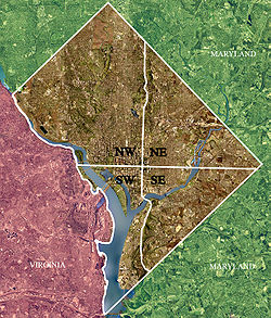
Washington, D.C., is administratively divided into four geographical quadrants of unequal size, each delineated by their ordinal directions from the medallion located in the Crypt under the Rotunda of the Capitol. Street and number addressing, centered on the Capitol, radiates out into each of the quadrants, producing a number of intersections of identically named cross-streets in each quadrant. Originally, the District of Columbia was a near-perfect square but contained more than one settlement; the Capitol was to be the center of the City of Washington. Thus, the Capitol was never located at the geographic center of the whole territory, which was eventually north of the Potomac River, consolidated into one city. As a result, the quadrants are of greatly varying size. Northwest is quite large, encompassing over a third of the city's geographical area, while Southwest is little more than a few neighborhoods, large parks, and a military base.

<span class="mw-page-title-main">Outline of Washington, D.C.</span> Overview of and topical guide to District of Columbia

The following outline is provided as an overview of and topical guide to District of Columbia:

<span class="mw-page-title-main">Martin Luther King Jr. Avenue</span> Street in District of Columbia, USA

Martin Luther King Jr. Avenue is a major street in the District of Columbia traversing through both the Southwest and Southeast quadrants.

References

  1. Rolark Barnes, Denise. "Martin Luther King Avenue, Where Hope Lives". Washington Informer. Retrieved November 22, 2011.
  2. DePillis, Lydia (July 11, 2011). "Barry: No More Renters in Ward 8!". Washington City Paper. Retrieved November 22, 2011.
  3. Johnson, Darragh; Roberts, Roxanne (July 18, 2007). "Washington's Mayor for Life To Be Truly Immortalized – in Wax". The Washington Post. p. B01.
  4. Sandalow, Marc (March 1, 2008). "A Brand-New Ballgame: The New Stadium of the Nationals". Washingtonian. Retrieved November 22, 2011.
  5. "Metrorail Interactive Map". Metro - Rail - Maps - Rail/Google Map. WMATA. Archived from the original on June 3, 2010. Retrieved June 26, 2015.
  6. Layton, Lyndsey (August 3, 2003). "Metrobuses Face Rock Attacks On Streets of Southeast D.C." The Washington Post. Retrieved April 23, 2018.
  7. "Point 2 Homes". Southeast Washington D.C. Demographics & Statistics. Retrieved June 26, 2015.

38°52′N76°59′W / 38.87°N 76.98°W / 38.87; -76.98