The National Mall is a landscaped park near the downtown area of Washington, D.C., the capital city of the United States. It contains and borders a number of museums of the Smithsonian Institution, art galleries, cultural institutions, and various memorials, sculptures, and statues. It is administered by the National Park Service (NPS) of the United States Department of the Interior as part of the National Mall and Memorial Parks unit of the National Park System. The park receives approximately 24 million visitors each year.

Waterfront station is a Washington Metro station in the Southwest Waterfront neighborhood of Washington, D.C., United States. The station was opened on December 28, 1991, and is operated by the Washington Metropolitan Area Transit Authority (WMATA). Waterfront is located in the Southwest Waterfront neighborhood at the intersection of 4th and M Streets SW.

L'Enfant Plaza is a complex of four commercial buildings grouped around a large plaza in the Southwest section of Washington, D.C., United States. Immediately below the plaza and the buildings is La Promenade shopping mall.

Constitution Avenue is a major east–west street in the northwest and northeast quadrants of the city of Washington, D.C., in the United States. It was originally known as B Street, and its western section was greatly lengthened and widened between 1925 and 1933. It received its current name on February 26, 1931, though it was almost named Jefferson Avenue in honor of Thomas Jefferson.

The history of Washington, D.C., is tied to its role as the capital of the United States. The site of the District of Columbia along the Potomac River was first selected by President George Washington. The city came under attack during the War of 1812 in an episode known as the Burning of Washington. Upon the government's return to the capital, it had to manage the reconstruction of numerous public buildings, including the White House and the United States Capitol. The McMillan Plan of 1901 helped restore and beautify the downtown core area, including establishing the National Mall, along with numerous monuments and museums.

The DC Circulator is a bus system in Washington, D.C. The District of Columbia Department of Transportation operates the service in a public–private partnership with RATP Dev.
The streets and highways of Washington, D.C., form the core of the surface transportation infrastructure in Washington, D.C., the federal capital of the United States. Given that it is a planned city, the city's streets follow a distinctive layout and addressing scheme. There are 1,500 miles (2,400 km) of public roads in the city, of which 1,392 miles (2,240 km) are owned and maintained by city government.
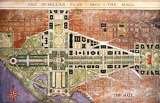
The McMillan Plan is a comprehensive planning document for the development of the monumental core and the park system of Washington, D.C., the capital of the United States. It was written in 1902 by the Senate Park Commission. The commission is popularly known as the McMillan Commission after its chairman, Senator James McMillan of Michigan.
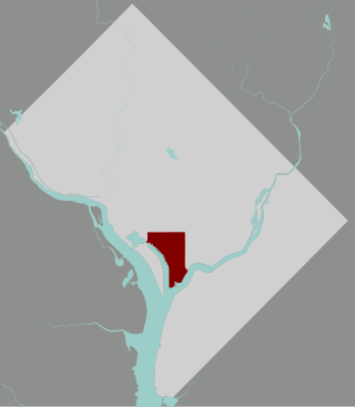
The Southwest Waterfront is a neighborhood in Southwest Washington, D.C. The Southwest quadrant is the smallest of Washington's four quadrants, and the Southwest Waterfront is one of only two residential neighborhoods in the quadrant; the other is Bellevue, which, being east of the Anacostia River, is frequently, if mistakenly, regarded as being in Southeast

The National Capital Planning Commission (NCPC) is a U.S. government executive branch agency that provides planning guidance for Washington, D.C., and the surrounding National Capital Region. Through its planning policies and review of development proposals, the Commission seeks to protect and enhance the extraordinary resources of the national capital.

Navy Yard, also known as Near Southeast, is a neighborhood on the Anacostia River in Southeast Washington, D.C. Navy Yard is bounded by Interstate 695 to the north and east, South Capitol Street to the west, and the Anacostia River to the south. Approximately half of its area is occupied by the Washington Navy Yard, which gives the neighborhood its name. The neighborhood is located in D.C.'s Ward 8, currently represented by Trayon White. It is served by the Navy Yard – Ballpark Metro station on the Green Line.

Southwest Federal Center is a business district in Southwest Washington, D.C., nearly entirely occupied by offices for various branches of the U.S. Government, including many of the museums of the Smithsonian Institution.

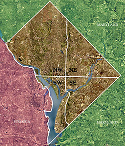
Washington, D.C., is administratively divided into four geographical quadrants of unequal size, each delineated by their ordinal directions from the medallion located in the Crypt under the Rotunda of the Capitol. Street and number addressing, centered on the Capitol, radiates out into each of the quadrants, producing a number of intersections of identically named cross-streets in each quadrant. Originally, the District of Columbia was a near-perfect square. However, even then the Capitol was never located at the geographic center of the territory. As a result, the quadrants are of greatly varying size. Northwest is quite large, encompassing over a third of the city's geographical area, while Southwest is little more than a neighborhood and military base.
The Capitol Riverfront is a business improvement district (BID) located just south of the United States Capitol between Capitol Hill and the Anacostia River in Washington, D.C. It was created by the District of Columbia City Council and approved by Mayor Fenty in August 2007. The BID is a mixed-use neighborhood. It was a former industrial area transformed into a business center, urban neighborhood, entertainment district, and waterfront destination. The project involves adding over 9,000 new apartments, condominiums, lofts, modern office towers, 1,200 hotel rooms, one million square feet of retail amenities, two grocery stores, new restaurants, shops, and cafes. Over 33,900,000 square feet of office, residential, hotel, and retail space, as well as four new parks, were planned over 10–15 years. The new 5-acre (20,000 m2) riverfront Yards Park opened in fall 2010.

Buzzard Point is an urbanized area located on the peninsula formed by the confluence of the Potomac and Anacostia Rivers in the southwest quadrant of Washington, D.C.

The James V. Forrestal Building is a low-rise Brutalist office building in Washington, D.C. Originally known as Federal Office Building 5, and nicknamed the Little Pentagon, the Forrestal Building was constructed between 1965 and 1969 to accommodate United States armed forces personnel. It is named after James Forrestal, the first United States Secretary of Defense. It became the headquarters of the United States Department of Energy after that agency's creation in 1977.

The Anacostia Riverwalk Trail is a multi-use trail system in Washington, DC, which, when complete, will be ~25 miles long, spanning both sides of the Anacostia River, the Washington Channel waterfront, and projecting into neighborhoods away from the Anacostia. It has more recently been branded as part of a larger Anacostia Riverwalk Trail Network which includes an additional 8 segments and 15 miles of trail. On the north end it connects to the Anacostia Tributary Trail System; on the south end it will connect to the Oxon Hill Farm Trail and on the west it connects to the Rock Creek Park Trail and the 14th Street Bridge. Of the 19 planned segments, 14 are complete for a combined total of 16 miles.
A United States postage stamp and the names of a number of recreational and cultural facilities, schools, streets and other facilities and institutions throughout the United States have commemorated Benjamin Banneker's documented and mythical accomplishments throughout the years since he lived (1731–1806). Among such memorializations of this free African American almanac author, surveyor, landowner and farmer who had knowledge of mathematics, astronomy and natural history was a biographical verse that Rita Dove, a future Poet Laureate of the United States, wrote in 1983 while on the faculty of Arizona State University.
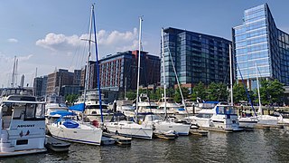
The Wharf, formally The District Wharf, is a multi-billion dollar mixed-use development on the Southwest Waterfront in Washington, D.C. It contains the city's historic Maine Avenue Fish Market, hotels, residential buildings, restaurants, shops, parks, piers, docks and marinas, and live music venues. The first phase of The Wharf opened in October 2017 and the second and final phase was completed in October 2022. The neighborhood encompasses 24 acres of land, 50 acres of water, and contain 3.2 million square feet (300,000 m2) of retail, residential, and entertainment space along 1 mile (1.6 km) of the Potomac River shoreline from the Francis Case Memorial Bridge to Fort McNair.

Washington, D.C., the capital of the United States, has a unique and diverse architectural history. Encompassing government, monumental, commercial, and residential buildings, D.C. is home to some of the country's most famous and popular structures designed by some of the leading architects of their time. The popularity of the city's buildings is reflected in the findings of a 2007 poll of Americans by the American Institute of Architects, which found that six of the top 10 most popular U.S. structures were located in Washington, D.C. Overall, the poll found, 17 of the top 150 most popular structures were located in the capital.