Buzzard Point

Last updated
Buzzard Point
BuzzardPointSW-0092-122122 (cropped).jpg
Building in Buzzard Point 2020 (cropped).jpg
Buzzard Point Plant 2020b.jpg
Top: Aerial view of Audi Field and Buzzard Point; bottom: new apartments (left) and Pepco Buzzard Point Plant (right)
GreenleafPoint.JPG
Coordinates: 38°52′06″N77°00′45″W / 38.868196°N 77.012551°W / 38.868196; -77.012551
CountyUnited States
District Washington, D.C.
Quadrant Southwest

Buzzard Point, sometimes known as Greenleaf Point, is a peninsula and neighborhood of Washington, D.C., located in Southwest D.C., at the confluence of the Potomac and Anacostia River. [1]

Contents

History

17th and 18th centuries

Captain Joseph Johnson House (49 T Street SW) in 1935. Historic American Buildings Survey Albert S. Burns, Photographer September 30, 1935 VIEW FROM SOUTHEAST - Captain Joseph Johnson House, 49 T Street Southwest, Buzzards Point, HABS DC,WASH,100-5.tif
Captain Joseph Johnson House (49 T Street SW) in 1935.

The earliest documented name for the tip of the peninsula that now constitutes the area known as Buzzard Point was Turkey Buzzard Point, in use by 1673 when it appeared on a map published by Augustine Herman, a Bohemian explorer and one of the early European settlers of the Eastern Shore of Maryland. [2] This name — often shortened to Buzzard Point remained in use until the federal capital was planned during the 1790s, at which time it became Young's Point, from one Notley Young, the then owner of the land. Very soon after that, it was renamed Greenleaf's Point, or Greenleaf Point, after James Greenleaf, a land speculator and purchaser of numerous lots in the new city, many of which were located in the vicinity of the Point. [2]

George Washington had intended the military to use some of Greenleaf's lots at the Point, including for defensive works. In 1791, he and Pierre Charles L'Enfant chose the site for the emplacement of a redoubt of some sort. [3] They acquired approximately 28 acres (110,000 m2) by a deed of trust during that year and confirmed it in a July 25, 1798, executive order. L'Enfant intended for a fortification to be placed there, according to his city plan, setting it aside as "Military District No. 5", because, as one author wrote, the "peninsula where the Potomac and Anacostia Rivers met was an obvious, natural military site." This site, sported a "one-gun battery mounted behind earth breastworks," possibly as early as 1791 but, at any rate, definitely by 1794. Within a few years, "The U.S. Arsenal at Greenleaf Point" grew from 28 to more than 89 acres (360,000 m2).

19th century

By 1803, the Fort was first referred to as an arsenal and the U.S. Congress provided money to construct additional buildings. During the American Civil War, experiments on new weaponry were performed both at the nearby Washington Navy Yard and the Washington Arsenal as the Army installation had come to be named. Breechloaders, the Spencer carbine, and the Gatling gun were among the weapons tested on the peninsula. In 1908, the peninsula's tip had the name Arsenal Point because of its military use at the time. [2] Washington Arsenal was renamed Fort Lesley J. McNair in 1948.

From its earliest times, the point was primarily ignored by the city's population since it was largely isolated within the city. L’Enfant's and Washington's hopes for bustling river traffic at Buzzard Point wharves never came to be; instead, the area south of Q Street SW and between South Capitol and the Fort retained a predominantly rural aspect. Wrote an early resident of this period: "From the Navy Yard westward along the Eastern Branch [the Anacostia] to Greenleaf's Point was a wild stretch of land with here and there a hovel or a house, and a stouring of brick kilns." [4] The marshy James Creek, flowing alongside the Arsenal (canalized in 1866 as the James Creek Canal but never connected to the existing Washington Canal), served only as a source of disease, often used for trash dumping.

An 1875 survey of Buzzard Point (below Q) found only 36 residences, eight "shanties," and six businesses. These numbers barely increased over the years. [5] Census numbers show the population peaking at 323 in 1894 (this from the Police Census for that year, found in the Metropolitan Police Annual Report) and then decreasing gradually: 231 in 1900; 185 in 1920; 19 in 1940. The area generally had proportions matched almost perfectly of black and white residents, living intermingled and all being of the working class. "Farmer" was the most common profession until about 1920 when "driver" replaced it.

The few accounts of this 1880–1920 period describe a modest community dominated by tidy truck gardens to the south and west and workers' houses and some small businesses along the eastern border from South Capitol to First Streets SW. "It is bordered on either side by true market gardens in the highest state of cultivation. The fields are interspaced with orchards of small fruit trees and occasionally these miniature farms have buildings set back from the road and profusely surrounded with chickens, stables and farm implements", The Washington Post reported on November 21, 1886. [6] The neighborhood was visited seldom by outsiders: "A stranger is a very strange thing on Buzzard Point." [7]

20th century

Buzzard Point Pepco Plant, viewed from the Anacostia River Buzzard Point Power Plant 2018 (cropped).jpg
Buzzard Point Pepco Plant, viewed from the Anacostia River

Deterioration was evident by the 1910s as fields were abandoned and the trash-strewn James Creek Canal was progressively filled in. Unpleasant semi-industrial uses crept down South Capitol Street, including trash, which was hauled legally or otherwise to various points along that street and the Anacostia River and also dumped into the river through the city's new sewage system. As the population decreased, city planners tried to plan other uses for this neglected area.

The city's new zoning system of 1920 optimistically implemented industrial zoning in the area of the Point, followed by the 1929 National Capitol Parks and Planning Commission's development planning report intending the area to be covered with railroad spurs and new large-scale manufacturing and utility uses that were unwelcome in other parts of the city. This effort destroyed what little was left of the old rural area without bringing in more than the railroad lines, including Pepco, a power plant and oil and gas storage facility. During the mid and late-20th century, these two major facilities and adjoining smaller ones were closed as new development began from the nearby Navy Yard area. Some boatyards and marinas maintained themselves on National Park Service-owned land along the Anacostia River.

Industry in the area tended to serve the growth of the city, with construction, demolition, and fuel companies dominating the waterfront. Other businesses served the Navy Yard factories. In the early 1960s, the Naval Gun Factory was shuttered and much of the supporting businesses left, concerning planners at the National Capital Planning Commission. The agency initiated several studies throughout the 1960s and 1970s that imagined considerably increased density along South Capitol Street and public parkland along the riverbank. While the plans had little traction, developers, the Washington, D.C. government, and the Federal City Council remained interested in the area. Lazlo Tauber, a developer, built two large buildings for federal offices. The buildings were mired in a scandal that implicated Spiro Agnew, but were eventually leased to the FBI and the U.S. Coast Guard.

The Federal City Council commissioned a study in 1981 promoting the area as a development area with great potential and little resistance. Pepco subsequently began to explore redeveloping its large holdings redevelopment in the 1980s, working with other developers to form a nonprofit called the Buzzard Point Planning Association. They hired the firm Keys Condon Florance, later Keyes Condon Florance Eichbaum Esocoff King, to create a detailed planning study. The FCC returned to complete a second plan, hiring Wallace Roberts Todd to develop its own plan for the area. Both plans were rejected by the District of Columbia's Office of Planning, who instead initiated the Buzzard Point/Near Southeast Vision 2020 Plan to balance these business interests with the needs of the broader community.

21st century

View of Buzzard Point and the Anacostia River Buzzard Point, Washington, DC.jpg
View of Buzzard Point and the Anacostia River
Audi Field Audi Field distance 2018-07-15 (43532680542).jpg
Audi Field

The development plans collapsed during the city's financial crisis. Nevertheless, interest in developing these areas persisted and the plans and policy set the pattern of development for the area that has followed. [8]

In 2022, developers announced construction would begin on a two million square foot mixed use project called The Stacks, which is expected to deliver in 2025. [9] The project will include 2,000 residential units and more than 80,000 square feet of retail space. Additionally, there will be hotels, restaurants, and a bowling alley on site. [10]

The United States Geological Survey's (USGS) most recent topographic maps identify the tip of the peninsula that contains Fort McNair as "Greenleaf Point". [11] The USGS maps also identify a lesser point to the northeast of Greenleaf Point as "Buzzard Point". [11] (James Creek, which was excavated during the 19th century to become a branch of the [now defunct] Washington City Canal, once separated these two points. Its name persists in the present-day James Creek Marina, located between the two named points. In early times, James Creek was also known as St. James Creek.)

Although officially the name of only a tip of the peninsula, the term "Buzzard Point" now serves to identify much or all of an urbanized area south of M Street SW and west of South Capitol Street SW, excluding Fort McNair. The area has long been known as an industrial part of the city. Buzzard Point is close to Nationals Park, and not far from the Waterfront and Navy Yard – Ballpark Metro stations. The Buzzard Point waterfront extends from the Fort along the west bank of the Anacostia River as far as South Capitol Street at the Frederick Douglass Memorial Bridge. From west to east along it from the Fort are the James Creek Marina, the former headquarters of the U.S. Coast Guard, Buzzard Point Marina, and Buzzard Point Park.

During 2007, Pepco Holdings announced that it sought to retire the Buzzard Point power plant by 2012. [12]

On July 25, 2013, a tentative deal was announced to have a 20,000-seat stadium for the D.C. United soccer team built at Buzzard Point and to cost $300 million. [13] [14] Audi Field opened July 14, 2018. [15]

Related Research Articles

<span class="mw-page-title-main">Anacostia River</span> River in Maryland and the District of Columbia, United States

The Anacostia River is a river in the Mid Atlantic region of the United States. It flows from Prince George's County in Maryland into Washington, D.C., where it joins with the Washington Channel and ultimately empties into the Potomac River at Buzzard Point. It is about 8.7 miles (14.0 km) long. The name "Anacostia" derives from the area's early history as Nacotchtank, a settlement of Necostan or Anacostan Native Americans on the banks of the Anacostia River.

<span class="mw-page-title-main">Southeast (Washington, D.C.)</span> Quadrant in the United States

Southeast is the southeastern quadrant of Washington, D.C., the capital of the United States, and is located south of East Capitol Street and east of South Capitol Street. It includes the Capitol Hill and Anacostia neighborhoods, the Navy Yard, the Joint Base Anacostia-Bolling (JBAB), the U.S. Marine Barracks, the Anacostia River waterfront, Eastern Market, the remains of several Civil War-era forts, historic St. Elizabeths Hospital, RFK Stadium, Nationals Park, and the Congressional Cemetery. It also contains a landmark known as "The Big Chair," located on Martin Luther King Jr. Avenue. The quadrant is split by the Anacostia River, with the portion that is west of the river sometimes referred to as "Near Southeast". Geographically, it is the second-smallest quadrant of the city.

<span class="mw-page-title-main">Southwest (Washington, D.C.)</span> Southwestern quadrant of Washington, D.C.

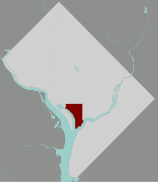
Southwest is the southwestern quadrant of Washington, D.C., the capital of the United States, and is located south of the National Mall and west of South Capitol Street. It is the smallest quadrant of the city, and contains a small number of named neighborhoods and districts, including Bellevue, Southwest Federal Center, the Southwest Waterfront, Buzzard Point, and the military installation known as Joint Base Anacostia–Bolling.

<span class="mw-page-title-main">Congress Heights</span> Neighborhood in Washington, D.C., U.S.

Congress Heights is a residential neighborhood in Southeast Washington, D.C., in the United States. The irregularly shaped neighborhood is bounded by the St. Elizabeths Hospital campus, Lebaum Street SE, 4th Street SE, and Newcomb Street SE on the northeast; Shepard Parkway and South Capitol Street on the west; Atlantic Street SE and 1st Street SE on the south; Oxon Run Parkway on the southeast; and Wheeler Street SE and Alabama Avenue SE on the east. Commercial development is heavy along Martin Luther King, Jr. Avenue and Malcolm X Avenue.

<span class="mw-page-title-main">History of Washington, D.C.</span>

The history of Washington, D.C., is tied to its role as the capital of the United States. The site of the District of Columbia along the Potomac River was first selected by President George Washington. The city came under attack during the War of 1812 in an episode known as the Burning of Washington. Upon the government's return to the capital, it had to manage the reconstruction of numerous public buildings, including the White House and the United States Capitol. The McMillan Plan of 1901 helped restore and beautify the downtown core area, including establishing the National Mall, along with numerous monuments and museums.

<span class="mw-page-title-main">Independence Avenue (Washington, D.C.)</span>

Independence Avenue is a major east-west street in the southwest and southeast quadrants of the city of Washington, D.C., in the United States, running just south of the United States Capitol. Originally named South B Street, Independence Avenue SW was constructed between 1791 and 1823. Independence Avenue SE was constructed in pieces as residential development occurred east of the United States Capitol and east of the Anacostia River. Independence Avenue SW received its current name after Congress renamed the street in legislation approved on April 13, 1934. Independence Avenue SW originally had its western terminus at 14th Street SW, but was extended west to Ohio Drive SW between 1941 and 1942. The government of the District of Columbia renamed the portion of the road in the southeast quadrant of the city in 1950.

<span class="mw-page-title-main">South Capitol Street</span>

South Capitol Street is a major street dividing the southeast and southwest quadrants of Washington, D.C., in the United States. It runs south from the United States Capitol to the D.C.–Maryland line, intersecting with Southern Avenue. After it enters Maryland, the street becomes Indian Head Highway at the Eastover Shopping Center, a terminal or transfer point of many bus routes.

<span class="mw-page-title-main">M Street (Washington, D.C.)</span> Four streets of the same name in Washington, D.C.

The name "M Street" refers to two major roads in the United States capital of Washington, D.C. Because of the Cartesian coordinate system used to name streets in Washington, the name "M Street" can be used to refer to any east-west street located twelve blocks north or south of the dome of the United States Capitol. Thus, in all four quadrants of the city there are streets called "M Street", which are disambiguated by quadrant designations, namely, M Street NW, NE, SW, and SE.

<span class="mw-page-title-main">DC Circulator</span> Bus system in Washington, D.C

The DC Circulator is a bus system in Washington, D.C. The District of Columbia Department of Transportation operates the service in a public–private partnership with RATP Dev.

<span class="mw-page-title-main">Fort Lesley J. McNair</span> United States Army post in Washington, D.C.

Fort Lesley J. McNair, also historically known as the Washington Arsenal, is a United States Army post located on the tip of Buzzard Point, the peninsula that lies at the confluence of the Potomac River and the Anacostia River in Washington, D.C. To the peninsula's west is the Washington Channel, while the Anacostia River is on its south side. The fort has been an army post for more than 200 years, third in length of service, after the United States Military Academy at West Point and the Carlisle Barracks. The fort is named for General Lesley James McNair, who was killed in action by friendly fire in Normandy, France during World War II.

<span class="mw-page-title-main">Washington City Canal</span>

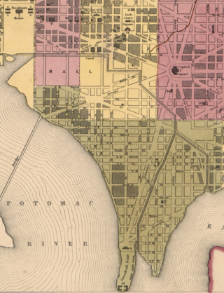
The Washington City Canal was a canal in Washington, D.C., that operated from 1815 until the mid-1850s. The canal connected the Anacostia River, termed the "Eastern Branch" at that time, to Tiber Creek, the Potomac River, and later the Chesapeake and Ohio (C&O) Canal. The canal fell into disuse during the late 19th century and the city government covered over or filled in various sections in 1871.

The streets and highways of Washington, D.C., form the core of the surface transportation infrastructure in Washington, D.C., the federal capital of the United States. Given that it is a planned city, the city's streets follow a distinctive layout and addressing scheme. There are 1,500 miles (2,400 km) of public roads in the city, of which 1,392 miles (2,240 km) are owned and maintained by city government.

<span class="mw-page-title-main">McMillan Plan</span> 1902 planning report for Washington, D.C.

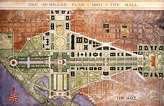
The McMillan Plan is a comprehensive planning document for the development of the monumental core and the park system of Washington, D.C., the capital of the United States. It was written in 1902 by the Senate Park Commission. The commission is popularly known as the McMillan Commission after its chairman, Senator James McMillan of Michigan.

<span class="mw-page-title-main">Southwest Waterfront</span> Neighborhood in Washington, D.C., United States

The Southwest Waterfront is a neighborhood in Southwest Washington, D.C. The Southwest quadrant is the smallest of Washington's four quadrants, and the Southwest Waterfront is one of only two residential neighborhoods in the quadrant; the other is Bellevue, which, being east of the Anacostia River, is frequently, if mistakenly, regarded as being in Southeast.

<span class="mw-page-title-main">Navy Yard (Washington, D.C.)</span> Place in the United States

Navy Yard is a neighborhood of Washington, D.C., located in Southeast D.C. Navy Yard, situated along the Anacostia Riverfront south of Capitol Hill, takes its name from Washington Navy Yard, the administrative seat of the U.S. Navy. Historically an industrial area, today Navy Yard is a popular entertainment district, home to Nationals Park, a notable nightlife scene, and numerous waterfront esplanades.

<span class="mw-page-title-main">Quadrants of Washington, D.C.</span> Geographical quadrant

Washington, D.C., is administratively divided into four geographical quadrants of unequal size, each delineated by their ordinal directions from the medallion located in the Crypt under the Rotunda of the Capitol. Street and number addressing, centered on the Capitol, radiates out into each of the quadrants, producing a number of intersections of identically named cross-streets in each quadrant. Originally, the District of Columbia was a near-perfect square but contained more than one settlement; the Capitol was to be the center of the City of Washington. Thus, the Capitol was never located at the geographic center of the whole territory, which was eventually north of the Potomac River, consolidated into one city. As a result, the quadrants are of greatly varying size. Northwest is quite large, encompassing over a third of the city's geographical area, while Southwest is little more than a few neighborhoods, large parks, and a military base.

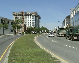
The Capitol Riverfront is a business improvement district (BID) located just south of the United States Capitol between Capitol Hill and the Anacostia River in Washington, D.C. It was created by the District of Columbia City Council and approved by Mayor Fenty in August 2007. The BID is a mixed-use neighborhood. It was a former industrial area transformed into a business center, urban neighborhood, entertainment district, and waterfront destination. The project involves adding over 9,000 new apartments, condominiums, lofts, modern office towers, 1,200 hotel rooms, one million square feet of retail amenities, two grocery stores, new restaurants, shops, and cafes. Over 33,900,000 square feet of office, residential, hotel, and retail space, as well as four new parks, were planned over 10–15 years. The new 5-acre (20,000 m2) riverfront Yards Park opened in fall 2010.

<span class="mw-page-title-main">P Street</span> Street in Washington, D.C., United States

P Street refers to four different streets within the city of Washington, D.C. The streets were named by President George Washington in 1791 as part of a general street naming program, in which east–west running streets were named alphabetically and north–south running streets numerically.

<span class="mw-page-title-main">James Creek</span>

James Creek was a tributary of the Anacostia River in the southwest quadrant of Washington, D.C., once known as St. James' Creek and perhaps named after local landowner James Greenleaf.

<span class="mw-page-title-main">Anacostia Riverwalk Trail</span> 25 mile multi-use trail system in Washington D.C.

The Anacostia Riverwalk Trail is a multi-use trail system in Washington, DC, which, when complete, will be ~25 miles long, spanning both sides of the Anacostia River, the Washington Channel waterfront, and projecting into neighborhoods away from the Anacostia. It has more recently been branded as part of a larger Anacostia Riverwalk Trail Network which includes an additional 8 segments and 15 miles of trail. On the north end it connects to the Anacostia Tributary Trail System; on the south end it will connect to the Oxon Hill Farm Trail and on the west it connects to the Rock Creek Park Trail and the 14th Street Bridge. Of the 19 planned segments, 14 are complete for a combined total of 16 miles.

References

Citations

  1. "Buzzard Point" in Google Maps. Accessed 2009-11-17.
  2. 1 2 3 Taggart, Hugh T. (1908), Georgetown (District of Columbia); Reprinted from Records of the Columbia Historical Society, Vol. 11, 1908; Lancaster, Pennsylvania: The New Era Printing Company, pages 9 & 11.
  3. L'Enfant identified himself as "Peter Charles L'Enfant" during most of his life while residing in the United States. He wrote this name on his "Plan of the city intended for the permanent seat of the government of t(he) United States ...." (Washington, D.C.) and on other legal documents. However, during the early 1900s, a French ambassador to the U.S., Jean Jules Jusserand, popularized the use of L'Enfant's birth name, "Pierre Charles L'Enfant". (See: Bowling (2002).) The National Park Service identifies L'Enfant as Major Peter Charles L'Enfant and as Major Pierre (Peter) Charles L'Enfant on its website. The United States Code states in 40 U.S.C. 3309: "(a) In General.The purposes of this chapter shall be carried out in the District of Columbia as nearly as may be practicable in harmony with the plan of Peter Charles L'Enfant."
  4. Sunderland, Bryan, "Washington As I Knew It", in Records of the Columbian Historical Society, vol. 5. CHS, Washington DC. 1902.)
  5. Kraft, Brian D., Old Southwest: A History of a Vanished Neighborhood. MS. 2006 (at Washingtoniana Div of MLK Library, Washington DC).
  6. Wash Post, November 21, 1886, p. 7.
  7. Evening Star, 30 July 1916, p. 48.
  8. Neil Flanagan (August 6, 2020). "Inflection Point". Washington City Paper. Retrieved May 2, 2021.
  9. "Big Buzzard Point development, with thousands of apartments, locks in financing". WTOP News. 2022-04-20. Retrieved 2022-11-09.
  10. "Brooklyn Bowl to bring lanes and concerts to Buzzard Point". WTOP News. 2022-11-04. Retrieved 2022-11-09.
  11. 1 2 United States Geological Survey topographic map with locations of Greenleaf Point and Buzzard Point in website of TopoQuest. Retrieved 2009-11-17.
  12. Pepco Holdings. (2007, February 28). Benning Road and Buzzard Point Units to be retired by 2012 [Press release]. Archived 2008-03-13 at the Wayback Machine
  13. "Deal reached for new stadium". StadiaDirectory. July 25, 2013. Archived from the original on 2013-09-27. Retrieved July 25, 2013.
  14. "Term Sheet: DC United Stadium Project" (PDF). District of Columbia and DC Soccer LLC. District of Columbia Office of the City Administrator. July 25, 2013. Archived from the original (PDF) on 2016-03-04.
  15. "D.C. United will open Audi Field on July 14, setting up All-Star Week on waterfront". Washington Post. January 4, 2018. Retrieved May 22, 2018.

Further reading