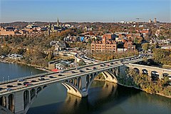
The Palisades, or simply Palisades, is a neighborhood in Washington, D.C., along the Potomac River, running roughly from the edge of the Georgetown University campus to the D.C.-Maryland boundary.

Friendship Heights is an urban commercial and residential neighborhood in northwest Washington, D.C., and southern Montgomery County, Maryland. Though its borders are not clearly defined, Friendship Heights consists roughly of the neighborhoods and commercial areas around Wisconsin Avenue north of Fessenden Street NW and Tenleytown to Somerset Terrace and Willard Avenue in Maryland, and from River Road in the west to Reno Road and 41st Street in the east. Within Maryland west of Wisconsin Avenue is the Village of Friendship Heights, technically a special taxation district.

Chevy Chase is a neighborhood in northwest Washington, D.C. It borders Chevy Chase, Maryland.

14th Street NW/SW is a street in Northwest and Southwest quadrants of Washington, D.C., located 1.25 miles (2.01 km) west of the U.S. Capitol. It runs from the 14th Street Bridge north to Eastern Avenue.

Neighborhoods in Washington, D.C., the capital of the United States, are distinguished by their history, culture, architecture, demographics, and geography. The names of 131 neighborhoods are unofficially defined by the D.C. Office of Planning. Neighborhoods can be defined by the boundaries of wards, historic districts, Advisory Neighborhood Commissions, civic associations, and business improvement districts (BIDs); these boundaries will overlap. The eight wards each elect a member to the Council of the District of Columbia and are redistricted every ten years.

There are many outdoor sculptures in Washington, D.C. In addition to the capital's most famous monuments and memorials, many figures recognized as national heroes have been posthumously awarded with his or her own statue in a park or public square. Some figures appear on several statues: Abraham Lincoln, for example, has at least three likenesses, including those at the Lincoln Memorial, in Lincoln Park, and the old Superior Court of the District of Columbia. A number of international figures, such as Mohandas Gandhi, have also been immortalized with statues. The Statue of Freedom is a 19½-foot tall allegorical statue that rests atop the United States Capitol dome.

Massachusetts Avenue is a major diagonal transverse road in Washington, D.C., and the Massachusetts Avenue Historic District is a historic district that includes part of it.

Connecticut Avenue is a major thoroughfare in the Northwest quadrant of Washington, D.C., and suburban Montgomery County, Maryland. It is one of the diagonal avenues radiating from the White House, and the segment south of Florida Avenue was one of the original streets in Pierre (Peter) Charles L'Enfant's plan for Washington. A five-mile segment north of Rock Creek was built in the 1890s by a real-estate developer.
The streets and highways of Washington, D.C., form the core of the surface transportation infrastructure in Washington, D.C., the federal capital of the United States. Given that it is a planned city, the city's streets follow a distinctive layout and addressing scheme. There are 1,500 miles (2,400 km) of public roads in the city, of which 1,392 miles (2,240 km) are owned and maintained by city government.

Downtown is the central business district of Washington, D.C., located in Northwest D.C. It is the third largest central business district in the United States. The "Traditional Downtown" has been defined as an area roughly between Union Station in the east and 16th Street NW in the west, and between the National Mall on the south and Massachusetts Avenue on the north, including Penn Quarter. However, nowadays, Downtown D.C. usually refers to a larger area, as the DC Office of Planning states:
…most residents, workers, and visitors think of Downtown in a broader sense — including areas as far north as Dupont Circle, as far west as Foggy Bottom, and as far east as Capitol Hill. Only about half of the central city workforce is located within the city’s traditional Downtown.
Washington, D.C., is the capital city and federal district of the United States. Below is a list of Washington, D.C.-related articles.

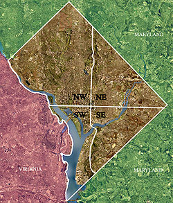
Washington, D.C., is administratively divided into four geographical quadrants of unequal size, each delineated by their ordinal directions from the medallion located in the Crypt under the Rotunda of the Capitol. Street and number addressing, centered on the Capitol, radiates out into each of the quadrants, producing a number of intersections of identically named cross-streets in each quadrant. Originally, the District of Columbia was a near-perfect square but contained more than one settlement; the Capitol was to be the center of the City of Washington. Thus, the Capitol was never located at the geographic center of the whole territory, which was eventually north of the Potomac River, consolidated into one city. As a result, the quadrants are of greatly varying size. Northwest is quite large, encompassing over a third of the city's geographical area, while Southwest is little more than a few neighborhoods, large parks, and a military base.

The following outline is provided as an overview of and topical guide to the District of Columbia:

The Kalorama Triangle Historic District is a mostly residential neighborhood and a historic district in the northwest quadrant of Washington, D.C. The entire Kalorama Triangle neighborhood was listed on the District of Columbia Inventory of Historic Sites (DCIHS) and National Register of Historic Places (NRHP) in 1987. In addition to individually listed landmarks in the neighborhood, the district is home to roughly 350 contributing properties. The neighborhood is roughly bounded by Connecticut Avenue to the west, Columbia Road to the east, and Calvert Street on the north.

Western Avenue is one of three boundary streets between Washington, D.C., and the state of Maryland. It follows a southwest-to-northeast line, beginning at Westmoreland Circle in the south and ending at Oregon Avenue NW in the north. It is roughly 3.5 miles (5.6 km) in length. First proposed in 1893, it was constructed somewhat fitfully from about 1900 to 1931.
George S. Cooper was an American architect and builder from Washington, D.C. During his 40-year career, he was responsible for designing around 850 properties, including homes, commercial buildings and apartment buildings, several of which are listed on the National Register of Historic Places (NRHP). The 1903 book History of the City of Washington states: "It may be thought that Mr. Cooper's forte lies in the designing of apartment houses, since the handsomest in the city are a result of his genius..." and "No young man has played a more important part in the active growth and great development of Greater Washington than George S. Cooper..."

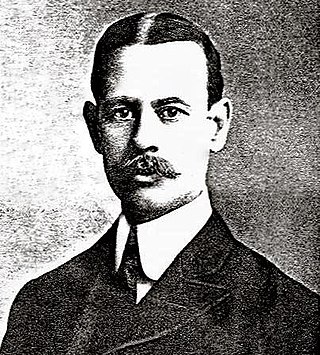
Appleton Prentiss Clark Jr. was an American architect from Washington, D.C. During his 60-year career, Clark was responsible for designing hundreds of buildings in the Washington area, including homes, hotels, churches, apartments and commercial properties. He is considered one of the city's most prominent and influential architects from the late 19th and early 20th centuries. Many of his designs are now listed on the National Register of Historic Places (NRHP).

The Sheridan-Kalorama Historic District is a neighborhood and historic district located in the northwest quadrant of Washington, D.C. The boundaries of the historic district include Rock Creek Park to the north and west, P Street to the south, and 22nd Street and Florida Avenue to the east. On the southwestern edge of the neighborhood is a stretch of Embassy Row on Massachusetts Avenue. The other neighborhood and historic district that lies to the east of Sheridan-Kalorama is Kalorama Triangle Historic District. The two neighborhoods are divided by Connecticut Avenue. For many years both neighborhoods were geographically connected before the stretch of Connecticut Avenue was installed toward the Taft Bridge. Oftentimes, both neighborhoods are simply called "Kalorama" or "Kalorama Heights".