Northwest is the northwestern quadrant of Washington, D.C., the capital of the United States, and is located north of the National Mall and west of North Capitol Street. It is the largest of the four quadrants of the city, and it includes the central business district, the Federal Triangle, and the museums along the northern side of the National Mall, as well as many of the District's historic neighborhoods.

Cleveland Park is a residential neighborhood in the Northwest quadrant of Washington, D.C. It is located at 38°56′11″N77°3′58″W and bounded approximately by Rock Creek Park to the east, Wisconsin and Idaho Avenues to the west, Klingle and Woodley Roads to the south, and Rodman and Tilden Streets to the north. Its main commercial corridor lies along Connecticut Avenue NW, where the eponymous Cleveland Park station of the Washington Metro's Red Line can be found; another commercial corridor lies along Wisconsin Avenue. The neighborhood is known for its many late 19th century homes and the historic Art Deco Uptown Theater. It is also home to the William L. Slayton House and the Park and Shop, built in 1930 and one of the earliest strip malls.

Forest Hills is a residential neighborhood in the northwest quadrant of Washington, D.C., United States, bounded by Connecticut Avenue NW to the west, Rock Creek Park to the east, Chevy Chase to the north, and Tilden Street NW to the south. The neighborhood is frequently referred to as Van Ness, both because of its proximity to the University of the District of Columbia (UDC)'s Van Ness campus, and because it is served by the Van Ness–UDC station on the Washington Metro's Red Line.
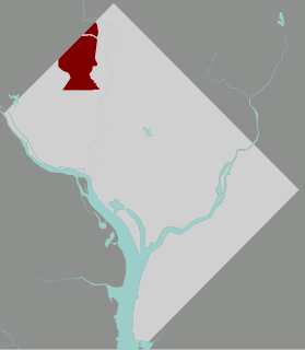
Chevy Chase is a neighborhood in northwest Washington, D.C. It borders Chevy Chase, Maryland, a collection of similarly affluent neighborhoods.
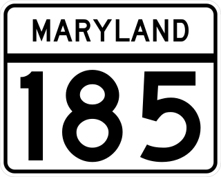
Maryland Route 185 is a state highway in the U.S. state of Maryland. Known as Connecticut Avenue, the state highway runs 8.30 mi (13.36 km) from Chevy Chase Circle at the Washington, D.C. border north to MD 97 in Aspen Hill. MD 185 serves as a major north-south commuter route in southern Montgomery County, connecting the District of Columbia with the residential suburbs of Chevy Chase, Kensington, and Wheaton.

Connecticut Avenue is a major thoroughfare in the Northwest quadrant of Washington, D.C., and suburban Montgomery County, Maryland. It is one of the diagonal avenues radiating from the White House, and the segment south of Florida Avenue was one of the original streets in Pierre (Peter) Charles L'Enfant's plan for Washington. A five-mile segment north of Rock Creek was built in the 1890s by a real-estate developer.

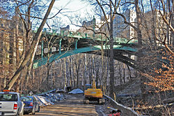
The Taft Bridge is a historic bridge located in the Northwest quadrant of Washington, D.C. It carries Connecticut Avenue over the Rock Creek gorge, including Rock Creek and the Rock Creek and Potomac Parkway, connecting the neighborhoods of Woodley Park and Kalorama. It is named after former United States president and Supreme Court Chief Justice William Howard Taft, and sits to the southwest of the Duke Ellington Bridge.
The Rock Creek Railway was one of the first electric streetcar companies in Washington, D.C., and the first to extend into Maryland. It was incorporated in 1888, started operations in 1890, and by 1892 ran some five miles from the Cardoza/Shaw neighborhood of D.C. to Chevy Chase Lake, Maryland. On September 21, 1895, Rock Creek Railway purchased the Washington and Georgetown Railroad Company and the two formed the Capital Traction Company.

Woodley Park is a neighborhood in Northwest, Washington, DC. It is bounded on the north by Woodley Road and Klingle Road, on the east by the National Zoo and Rock Creek Park, on the south by Calvert Street, on the southwest by Cleveland Avenue, and on the west by 34th Street.

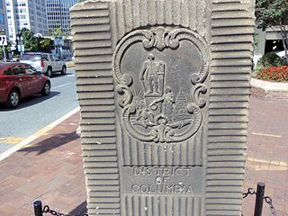
The boundary markers of the original District of Columbia are the 40 milestones that marked the four lines forming the boundaries between the states of Maryland and Virginia and the square of 100 square miles (259 km2) of federal territory that became the District of Columbia in 1801. Working under the supervision of three commissioners that President George Washington had appointed in 1790 in accordance with the federal Residence Act, a surveying team that Major Andrew Ellicott led placed these markers in 1791 and 1792. Among Ellicott's assistants were his brothers Joseph and Benjamin Ellicott, Isaac Roberdeau, George Fenwick, Isaac Briggs and an African American astronomer, Benjamin Banneker.
Klingle Road is a street in the northwest quadrant of Washington, D.C.
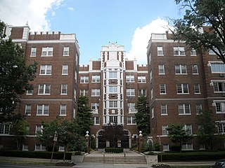
3901 Connecticut Avenue NW is a six-story Tudor Revival apartment building in the North Cleveland Park neighborhood of Washington, D.C. Designed by architect George T. Santmyers, 3901 Connecticut Avenue was built in 1927 for developer Harry Bralove. The building was added to the District of Columbia Inventory of Historic Sites on March 28, 1996, and listed on the National Register of Historic Places on September 11, 1997.

The following outline is provided as an overview of and topical guide to District of Columbia:

Chevy Chase Circle is a traffic circle straddling the border of Chevy Chase, Washington, D.C. and Chevy Chase, Maryland. It sits upon the convergence of Western Avenue, Grafton Street, Magnolia Parkway, Chevy Chase Parkway NW, and Connecticut Avenue.
The Garden Club of America Entrance Markers in Washington, D.C. is a Multiple Property Submission, or MPS, on the National Register of Historic Places. The seven structures that make up the MPS are ceremonial markers at important entrance points to the District of Columbia from the state of Maryland. Sets of two markers are located in Westmoreland Circle, Friendship Heights and Chevy Chase Circle. A single marker is located along Georgia Avenue.

Western Avenue is one of three boundary streets between Washington, D.C., and the state of Maryland. It follows a southwest-to-northeast line, beginning at Westmoreland Circle in the south and ending at Oregon Avenue NW in the north. It is roughly 3.5 miles (5.6 km) in length. First proposed in 1893, it was constructed somewhat fitfully from about 1900 to 1931.

Leon Emil Dessez was an American architect in Washington D.C. He designed public buildings in Washington D.C. and residences in Washington D.C., Maryland, and Virginia, including some of the first in Chevy Chase, Maryland, where he was the community's first resident. His work includes the 1893 the conversion of 1111 Pennsylvania Avenue, The Shepherd Centennial Building, into the Raleigh Hotel and the Normal School for Colored Girls (1913), designed with Snowden Ashford.

The Connecticut Avenue Line, designated Routes L1 and L2, is a daily bus route in Northwest Washington, D.C., United States. The L1 provides peak-direction rush hour service during weekdays, while the L2 operates seven days a week.
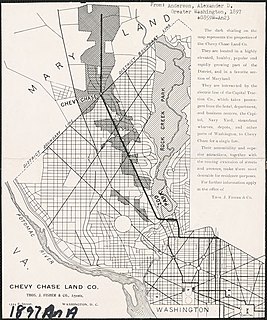
The Chevy Chase Land Company is a real estate holding and development company based in suburban Washington, D.C.