
Arlington County, or simply Arlington, is a county in the U.S. state of Virginia. The county is located in Northern Virginia on the southwestern bank of the Potomac River directly across from Washington, D.C., the national capital.

Fashion Centre at Pentagon City, originally the Pentagon City Mall, is an enclosed shopping mall in the Pentagon City neighborhood of Arlington, Virginia, near Interstate 395 and Hayes Street. Its Metro level is directly connected to the Pentagon City station on the Blue and Yellow Lines of the Washington Metro. The mall features Macy's and Nordstrom, and also houses the Ritz-Carlton Pentagon City hotel.
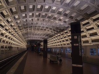
Foggy Bottom–GWU station is a Washington Metro station in the Foggy Bottom neighborhood of Washington, D.C., United States. The island-platformed station was opened on July 1, 1977, and is operated by the Washington Metropolitan Area Transit Authority (WMATA). Providing service for the Blue, Orange, and Silver Lines, the station is located on I Street on the George Washington University (GWU) campus. It is the last westbound station in the District of Columbia on these lines before they dive under the Potomac River to Virginia.

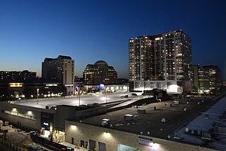
Crystal City is an urban neighborhood in the southeastern corner of Arlington County, Virginia, approximately 5 miles south of Downtown Washington, D.C. Due to its extensive integration of office buildings and residential high-rise buildings using underground corridors, travel between stores, offices, and residences, it is possible to travel much of the neighborhood without going above ground, making at least part of Crystal City an underground city.

Rosslyn station is the westernmost station on the shared segment of the Blue, Orange, and Silver lines of the Washington Metro. It is located in the Rosslyn neighborhood of Arlington County, Virginia. Rosslyn is the first station in Virginia heading westward from Washington, D.C. on the Orange and Silver Lines and southward on the Blue Line. It is one of four interchange points on the Metrorail system west of the Potomac River and located in a growing business district.

Pentagon City station is an underground Washington Metro station in the Pentagon City neighborhood of Arlington, Virginia, United States. It serves the Blue and Yellow Lines.

Capitol South station is a Washington Metro station in the Capitol Hill neighborhood of Washington, D.C., United States. The island-platformed station was opened on July 1, 1977, and is operated by the Washington Metropolitan Area Transit Authority (WMATA). The station currently provides service for the Blue, Orange, and Silver Lines.

Mount Pleasant is a neighborhood in Washington, D.C., located in Northwest D.C. The neighborhood is primarily residential, with restaurants and stores centered along a commercial corridor on Mt. Pleasant Street. Mount Pleasant is known for its unique identity and multicultural landscape, home to diverse groups such as the punk rock, the Peace Corps and Hispanic Washingtonian communities.
Pentagon City is an unincorporated neighborhood located in the southeast portion of Arlington County, Virginia. It is located near The Pentagon and Arlington National Cemetery.
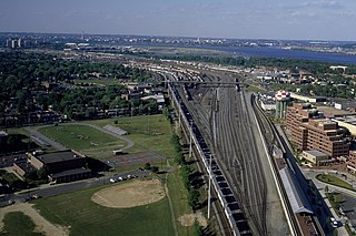
Potomac Yard is a neighborhood in Northern Virginia that straddles southeastern Arlington County and northeastern Alexandria, Virginia, located principally in the area between U.S. Route 1 and the Washington Metro Blue Line /Yellow Line tracks, or the George Washington Memorial Parkway, depending on the definition used. The area was home to what was once one of the busiest rail yards on the Eastern Seaboard of the United States. The "Potomac Yard" name is also used to refer to several developments in the area, especially the Potomac Yard Center power center and a Washington Metro station.

Lawrenceville is one of the largest neighborhood areas in Pittsburgh in the U.S. state of Pennsylvania. It is located northeast of downtown, and like many of the city's riverfront neighborhoods, it has an industrial past. The city officially divides Lawrenceville into three neighborhoods, Upper Lawrenceville, Central Lawrenceville, and Lower Lawrenceville, but these distinctions have little practical effect. Accordingly, Lawrenceville is almost universally treated as a single large neighborhood.

The Pentagon is the headquarters building of the United States Department of Defense, in Arlington County, Virginia, across the Potomac River from Washington, D.C. The building was constructed on an accelerated schedule during World War II. As a symbol of the U.S. military, the phrase The Pentagon is often used as a metonym for the Department of Defense and its leadership.

Metroway is a bus rapid transit (BRT) line operated by the Washington Metropolitan Area Transit Authority (WMATA) as part of their Metrobus system. It consists of a single line operating in Arlington and Alexandria, Virginia. It opened on August 24, 2014. It was the first bus rapid transit line to open in Virginia and in the Washington metropolitan area.
Morris Cafritz was a Washington, D.C. real estate developer, and philanthropist. As CEO of the Cafritz Company, he was Washington, D.C.'s largest private developer from the late 1920's to the early 1960's.

Amazon HQ2 is Amazon's corporate headquarters in National Landing in Crystal City, Virginia and an expansion of the company's headquarters in Seattle, Washington. Phase I, which has capacity for 14,000 employees, opened in June 2023. Construction on Phase II is delayed and there is no timeline for development.

National Landing is an area in Northern Virginia encompassing parts of the Crystal City and Pentagon City neighborhoods of Arlington County and the Potomac Yard neighborhood in the city of Alexandria. It is the location of the Amazon HQ2 headquarters.

The Columbia Pike Line, designated as Routes 16A, 16C & 16E, are daily bus routes operated by the Washington Metropolitan Area Transit Authority between the neighborhoods of Annandale (16A) or Culmore and Pentagon station of the Yellow and Blue lines of the Washington Metro or Franklin Square (16E). This line is part of the Pike Ride service, which runs through Columbia Pike. This line provides service to Annandale or Culmore and the Pentagon Transit Center or Franklin Square from the neighborhoods of Fairfax County and Arlington County. Alongside the neighborhoods, it also brings service through the marketplace, business, and offices through Columbia Pike.
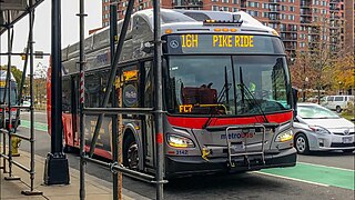
The Columbia Pike–Pentagon City Line, designated as Routes 16G & 16H, were daily bus routes that was operated by the Washington Metropolitan Area Transit Authority between the neighborhoods of Arlington Mill (16G) or Skyline City (16H) and Pentagon City station of the Yellow and Blue lines of the Washington Metro. This line is part of the Pike Ride service, which runs through Columbia Pike. This line provides service through the neighborhoods of Fairfax County and Arlington County to Pentagon City. Unlike the Columbia Pike Line, the Columbia Pike–Pentagon City Line does not serve Columbia Pike past the Arlington County line.
The Alexandria–Pentagon Line, designated as Routes 10A, 10E & 10N, is a daily bus route operated by the Washington Metropolitan Area Transit Authority between Huntington station of the Yellow Line of the Washington Metro (10A), Hunting Point (10E), or Ronald Reagan Washington National Airport station of the Yellow and Blue lines of the Washington Metro and Pentagon station of the Yellow and Blue lines of the Washington Metro. This line provides service within the neighborhoods in Fairfax County, Alexandria, and Arlington County. Alongside the neighborhoods, it also brings service through the marketplace, businesses, and offices within the counties.

The Columbia Pike–National Landing Line, designated as Route 16M, is a daily bus route operated by the Washington Metropolitan Area Transit Authority between Skyline City and Crystal City station of the Yellow and Blue lines of the Washington Metro. This line is part of the Pike Ride service, which runs through Columbia Pike. This line provides service through the neighborhoods of Fairfax County and Arlington County to Crystal City. Unlike the Columbia Pike Line, the Columbia Pike–National Landing Line does not serve Columbia Pike past the Arlington County line.

