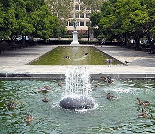
A large playground is located near its center, and the park also hosts a number of sport amenities such as tennis courts, a volleyball court, bocce courts, and a baseball backstop along with picnic tables and benches. The park is maintained by the DC Department of Parks and Recreation. It is categorized as a neighborhood park, which means that it provides an informal park settings for recreational purposes for the immediate neighborhood.[1]
This open space was originally included in the 1791 urban plan for Washington, L'Enfant Plan. The site may have been selected by L'Enfant because it contained several natural springs, and he indicated that it should be the site for a grand cascade.[2] It was to be the convergence of Virginia Avenue, South Carolina Avenue, and New Jersey Avenue, with the canal running along its western border, dividing into two branches just south of the park.[2]
Andrew Ellicott made the open space larger on his plan and extended North Carolina Avenue south several blocks so that it would also radiate from the park. The space designed by Ellicott was included among the original seventeen appropriations purchased by the federal government for public use. The land was purchased by the U.S. government from Daniel Carroll of Duddington[2] and designated as Reservation No. 17 or town House Square. The elegant, grand estate of Daniel Carroll, Duddington, faced the park from the North. This estate encompassed all of City Square No. 736 between First Street and Second Street and was constructed in 1793 with bricks from Carroll's own brickyard.[2][3][4][5]
1838 Tree Nursery
One paper claimed: Garfield Park, now one of the most beautiful parks in the city, was graded and to some extent improved in 1838 in connection with its use as a nursery for trees to ornament the public grounds and Pennsylvania Avenue.[2][6] However, the Boschke map of 1857-1861 depicts the space as being entirely unimproved.[2][7][8] Furthermore, a 1876 real estate atlas depicted the park as unimproved, showing New Jersey Avenue and Virginia Avenue continuing through it.[2]
1850 Citizens Petition for a Large Open Common
Citizens residing in the neighborhood petitioned Congress to fund improvements to the large open common. The portion of the park directly south of Duddington, between New Jersey Avenue and Second Street had a large supply of quarried rock that was used to make gravel to pave the streets of Washington, D.C.[2] Through the mid-1800s, the quarry excavations left large holes in the park. In his "Letter from the Commissioner of Public Buildings Transmitting His Annual Report for 1850" to the U.S. Congress House of Representatives, Ignatius Mudd regarded those holes as an intolerable nuisance.[2] Mudd recommended that area be graded and planted with trees and to protect its "copious springs," but to delay improvements to other areas of the park until the neighborhood population increased or at least until the adjacent streets were opened and graded.[2]
1867 Change in Leadership
Previously, the supervision of government areas had been under a commissioner of public buildings and grounds. In 1867, care and supervision of all reservations (original planned park lands) owned by the U.S. Federal Government was entrusted with Chief of Engineers of the United States Army for care and supervision. Appropriations for maintenance and improvement were documented in the Annual Report of the Secretary of War, Volume II. An officer in charge of public buildings and grounds, under his direction, was appointed to carry on this work. In 1898, Congress defined the jurisdiction of the municipal authorities and of the Chief of Engineers. Municipal authorities were assigned the streets and the parking along the streets. Chief of Engineers was assigned to all parks, reservations, triangles, and circles. In the wake of the Civil War, Congress apparently preferred to retain jurisdiction parks, etc., for the United States Government, rather than permit any municipal supervision that might conflict with the Government's needs. At the time, it was common knowledge that the point of view of the city authorities had conflicting goals with the established plans for the beautification of Washington, so that this separation of functions was likely retained for the greater protection of the parks and for their closer supervision.[9]
1880s Improvements
In the 1880s, the Office of Public Buildings and Grounds (OPB&G) took responsibility and management of embellishments of Reservation No. 17, beginning with restoring that land taken by several roadways now paved through the park.
In the Annual Report of the Secretary of War for the Year 1881, Volume II Part 3, OPB&G Colonel Almon Ferdinand Rockwell, a close, personal friend of both Presidents Abraham Lincoln and James A. Garfield, who was then charged with maintaining the Public Buildings and Grounds in the District of Columbia, entered that $20,000 was spent "for commencing improvement of reservation No. 17 and site of old canal northwest of same."[10]
Evening Star, Aug. 22, 1883 p. 1 Indian [Native American] Remains, Etc., Found. What the Workmen Grading a Public Reservation Have Dug Up.
In an 1883 report, OPB&G Colonel Almon Ferdinand Rockwell described Reservation 17 as "located in a section of the city which, up to this date, has not been highly improved by private enterprise." Rockwell requested $20,000 for improvements to Reservation 17 "to make this park one of the principal resorts of the city, with extensive roadways for carriage drives and walks conveniently located for pedestrian passage." Rockwell wrote:
New Jersey Avenue, which cuts through this reservation, was paved with granite blocks some years since by the District's authorities. As the plan for the improvement of Reservation 17 provides for the incorporation in it of that portion of this avenue which traverses the grounds, the District Commissioners were granted permission, upon application, to take up and remove for use in District improvements such number of the granite blocks as they might wish, and some 38,000 blocks were accordingly so removed by them during the months of September and October last.
In 1883, Native American remains were found during grading excavations, directly south of the estate, which suggests that the location may have been the site of a Nacotchtank settlement. [11][12][13]
By late 1885, the park was being referred to as Garfield Park in reports, such as Annual Report of the Secretary of War, Vol. II Pt. 1 dated Oct. 16, 1885, p. 374.
Improvement and Care of Public Buildings and Grounds in the District of Columbia. Officer in charge, Col. A. F. Rockwell, TU. S. Army, from July 1, 1884, to June 1, 1885; since that (late, Lient. Col. John M. Wilson, Corps of Engineers, Colonel, U. S. Army. In addition to the work performed for maintaining in good condition the improved public reservations, extensive improvements have been made at Folger Park, Washington Circle, Garfield Park, and the reservation on South Carolina avenue between Fourth and Sixth streets. An additional plant-house was constructed in the nursery south of the Monument Grounds.
Also, it is in Vol. II Pt. 3 of the Annual Report of the Secretary of War dated Dec. 07, 1885, p. 2507:
RESERVATION NO. 17-GARFIELD PARK. Operations were continued during the year -- grading, setting curb, laying out walks and roads, placing water-pipes in position, &c.; 5,500 cubic yards of soil, 1,200 cubic yards of gravel, and 400 cubic yards of earth were purchased and used in this park during the year; 4,818 linear feet of iron water pipe, from 1 to 4 inches in diameter, was placed in position and outlets introduced for twenty-three 11 inch hose-valves; 1,351 deciduous trees were removed from the Monument Nursery and planted in a temporary nursery at the reservation; they will be set out in the fall of 1885; about 1,000 feet of granite curbing was set on the boundaries of the reservation bordering E street, and 1,000 feet rejointed and parred for setting on the northwestern boundary lines of the park. During the present season operations will be continued; setting curb, laying brick sidewalks, laying out roads and paths, planting trees, etc.; about 3,000 yards of soil, 2,000 yards of gravel, and 150,000 bricks will be purchased for these purposes.
Duddington Manor, built by one of the city's original landowners, Daniel Carroll of Duddington, was razed in 1886 to be replaced by row houses.[3]In 1886, the roadway entrance to the park on Second Street and F Street was paved with cobblestone; the surrounding sidewalks were paved with brick.[2]
Between 1886 and 1892, OPB&G landscapers planted 6,500 trees in the park, laid paths along the lines of travel, and assigned a day and a night watchman to protect and to maintain the property. By 1887, $78,500 was invested in improvements to the park, the eastern section was nearly complete, more than 2,000 deciduous and evergreen trees and shrubs growing in the park were being cared for by OPB&G.[2]
The gravel roads leading through the park to Virginia Avenue were used by heavy teams associated with nearby railroad, construction, and industry, forcing constant repair. In 1892, the park was damaged with the Grand Army of the Republic camped there for its 26th annual reunion, erecting barracks and a mess hall.[2]
1900s Garfield Park is 23.9 acres
By 1901, the newly constructed Josiah Dent public elementary school adjacent to the park at South Carolina Avenue and Second Street, used the park as a playground for students.[2]
In 1902, the Senate Report 'The Improvement of the Park System in the District of Columbia' listed Garfield Park as 'Between South Capitol Street and Third Street east, at intersection of New Jersey and Virginia Avenues, and being 23.9 acres in size.[14]
In 1903, a portion of the park south of Virginia Avenue was granted by Congress to the Pennsylvania Railroad Company, which then erected an 8-foot-tall board fence to partition its land from the park. The change in grades imposed by the railroad construction forced a redesign of the park. In 1904, a tool house, workshop, and office room were framed in the northeast corner, while large public sewer was laid beneath the park, with temporary shed for storage of construction equipment.[2]
1905 Capitol Power Plant
In 1905, Congress transferred more than 6 acres to be used as a building site for heating, lighting, and a power plant for the Capitol, the Capitol Power Plant. Cast-iron posts from the post-and-chain fence were erected that year around the portion of the park bounded by New Jersey Avenue and First Street.[2]
In 1913, the park was completely redesigned and included new lights.[2]
In 1915, the Treasury Department let a contract for a Government Capitol Power Plant (December 24, 1915). A 1916 report states that in spite of the executive order (Nov. 28, 1913) this most important matter was not submitted to the National Fine Arts Commission until January 14, 1916, twenty-one days after contract was given.[9] "The Commission strongly disapproves the plans of this structure, and views with grave anxiety the location of any such plant on this site." (January 26, 1916.)[9] A resolution was introduced in the Senate, asking for a reconsideration of the power plant building and site. (S. J. Resolution 92, January 29, 1916.)[9][15]
1916 Garfield Park is reduced to 9.313 acres
In 1916, Garfield Park is listed as being 9 acres in a report that also says that since 1867, not a single park has ever been placed by Congress under the exclusive charge of the municipal authorities for park purposes.[9] Previous to 1867, the protection of park property was a duty of the municipal police, but, since main object of the municipal police is the detection and prevention of crime, protection of park property was often considered beneath their dignity; therefore, it was neglected.[9] By 1916, the oversight gap was filled by the establishment a force of watchmen who were constantly on the alert to prevent trespass and other encroachment on the public grounds.[9] Congress first funded then gave police powers to this force of watchmen which later organized as a distinct body, and by 1916 was uniformed and mounted on bicycles at Government expense.[9] Because of other construction, a new lodge was erected. That 1026-foot lodge was erected to provide toilets for visitors and a 556-foot playground house was used by children in organized play.[2]
1920s Garfield Park Concert Common
Garfield Park region of the April 13, 1928 United States Army. Air Corps. Aerial Photo Section No. 3. Photographic mosaic map, Washington, D.C. [Bolling Field, Washington, D.C.: The Section, 1928] Map. https://www.loc.gov/item/87693347/.
Neighborhood residents heavily used the park for rest and recreation in the first decades of the 20th century. The landscape plan installed in the 1920s included a large elliptical area at the east side which was referred to as the Concert Common since there were weekly band concerts during the summer. The park also boasted tennis courts, basketball courts, croquet, quoits, and volleyball court. There were wading pools and sandboxes for children.
A 1924 blueprint[2] of the site indicates that the construction for the concrete walks around the park used 1,640.8 linear feet, with a width of 5.68 feet, for a total of 7,640.6 square feet. For brick walkways, there was 3,281.6 linear feet at a width of 8.27 feet, for a total of 27,142.6 square feet. A stone wall was 399.01 linear feet at a width of 1.25 feet for a total of 31.26 square feet. Coping had 15.7 linear feet of posts concrete of width 1.25 feet for a total of 31.26 square feet. The concrete for the coping was 854.27 linear feet of width 0.75 feet for a total of 643.29 feet. The tennis court was 5,355.0 square feet. The Quoit Court, 2 in total, were 650 square feet. The basketball court was 2,600 square feet. The two wading pools together were 1,520 square feet. The children's playground was 23,406 square feet. The volleyball court was 910 square feet. The Croquet Court was 1,787.5 square feet. Dodge Ball Court was 593.95 square feet. Together the two sandboxes were 392 square feet. There were 69 benches, 6 kindergarten benches, 3 drinking fountains, 3 kindergarten tables, 17 gas lamp posts, 13 valve boxes, 16 water-stand pipes, 7 drainage traps, 6 trash baskets, and 132 posts. There was 1014 linear feet of post and chain. There was 328 linear feet back stop and 292 linear feet of trespass irons. There were 20,245 square feet of shrub beds, 5,232 square feet of flower beds, and 305,165.94 square feet of lawn. The hedge was 279 linear feet, 1.5 feet wide, and 3.3 feet tall, with area of 920.7 square feet. There were 372 trees of various species. The Toilet and Ledge was 1,026.2 square feet. The playground house was 555.6 square feet. And a metal garage was 163.1 square feet. The concrete walks were 4,096.45 linear feet and 28,263.36 square feet. The brick walks were 434.8 linear feet and 4,398 square feet. The gravel walks were 40.3 linear feet and 157.2 square feet.
1940s Neighborhood Park and Sports Center
Basketball great, Elgin Baylor, who lived a block away on Duddington Place, shot hoops in the park growing up.[16] At one point, the Park had a wading pool,[17] which consistent with the times was segregated.
In 1948, the park was part of a summer-long experiment on the racial integration of playgrounds in the District.[18] Integration at Garfield Park was noted as being more difficult. At the time the neighborhood was approximately 25% white. The integration of the wading pool and baseball field was deemed unsuccessful due to strong opposition by white neighbors and was discontinued. The Supreme Court's decision, Bolling v. Sharpe, 347 U.S. 497 (1952), the landmark Supreme Court that desegregated public schools in the District of Columbia, ended all segregation within the city.
1969 Interstate 695
In 1969, 95,470 square feet on the south side were transferred to jurisdiction of the District of Columbia to construct the Southeast/Southwest Freeway, now called Interstate 695. When this part of the park was transferred to the District of Columbia for the construction of Interstate 695 in 1969. A basketball court, still accessible from the park, was built underneath the highway to mitigate the loss of park space. Also, traffic was closed to Second Street, which had always continued through the park. That section of Second Street roadbed was broken up and sodding was put down in its place.
1972 Garfield Park is 7.1 acres
Ownership of the remaining 7.1-acre park was transferred to the District of Columbia in 1972.[2]
Related Research Articles
Capitol Hill is a neighborhood in Washington, D.C., located in both Northeast D.C. and Southeast D.C.. Bounded by 14th Street SE & NE, F Street NE, Southeast Boulevard SE, South Capitol Street SE. Dominated by the United States Capitol, which sits on the highest point of Capitol Hill, it is one of the oldest historic districts in Washington. Home to around 35,000 people in just under 2 square miles (5 km2), Capitol Hill is also one of the most densely populated neighborhoods. The name "Capitol Hill" is frequently used as a metonym for the U.S. Congress.
Judiciary Square is a neighborhood in the northwest quadrant of Washington, D.C., the vast majority of which is occupied by various federal and municipal courthouses and office buildings. Judiciary Square is located roughly between Pennsylvania Avenue to the south, H Street to the north, 6th Street to the west, and 3rd Street to the east. The center of the neighborhood is an actual plaza named Judiciary Square. The Square itself is bounded by 4th Street to the east, 5th Street to the west, D Street and Indiana Avenue to the south, and F Street to the north. The neighborhood is served by the Judiciary Square station on the Red Line of the Washington Metro, in addition to Washington Metropolitan Area Transit Authority bus stops.
Constitution Avenue is a major east–west street in the northwest and northeast quadrants of the city of Washington, D.C., in the United States. It was originally known as B Street, and its western section was greatly lengthened and widened between 1925 and 1933. It received its current name on February 26, 1931, though it was almost named Jefferson Avenue in honor of Thomas Jefferson.
There are many outdoor sculptures in Washington, D.C. In addition to the capital's most famous monuments and memorials, many figures recognized as national heroes have been posthumously awarded with his or her own statue in a park or public square. Some figures appear on several statues: Abraham Lincoln, for example, has at least three likenesses, including those at the Lincoln Memorial, in Lincoln Park, and the old Superior Court of the District of Columbia. A number of international figures, such as Mohandas Gandhi, have also been immortalized with statues. The Statue of Freedom is a 19½-foot tall allegorical statue that rests atop the United States Capitol dome.
Independence Avenue is a major east-west street in the southwest and southeast quadrants of the city of Washington, D.C., in the United States, running just south of the United States Capitol. Originally named South B Street, Independence Avenue SW was constructed between 1791 and 1823. Independence Avenue SE was constructed in pieces as residential development occurred east of the United States Capitol and east of the Anacostia River. Independence Avenue SW received its current name after Congress renamed the street in legislation approved on April 13, 1934. Independence Avenue SW originally had its western terminus at 14th Street SW, but was extended west to Ohio Drive SW between 1941 and 1942. The government of the District of Columbia renamed the portion of the road in the southeast quadrant of the city in 1950.
The National Capital Parks was a unit of the National Park System of the United States, now divided into multiple administrative units. It encompasses a variety of federally owned properties in and around the District of Columbia including memorials, monuments, parks, interiors of traffic circles and squares, triangles formed by irregular intersections, and other open spaces.
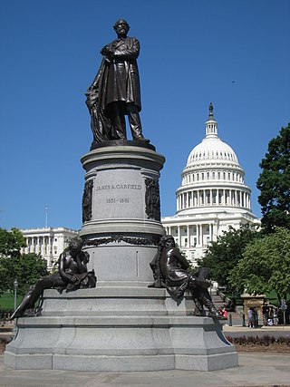
The James A. Garfield Monument stands on the grounds of the United States Capitol in the traffic circle at First Street and Maryland Avenue SW in Washington, D.C. It is a memorial to U.S. President James A. Garfield, who was elected in 1880 and assassinated in 1881 after serving only four months of his term. The perpetrator was an attorney and disgruntled office-seeker named Charles J. Guiteau. Garfield lived for several weeks after the shooting, but eventually succumbed to his injuries. The monument is part of a three-part sculptural group near the Capitol Reflecting Pool, including the Peace Monument and the Ulysses S. Grant Memorial in Union Square. The monument is also a contributing property to the National Mall and L'Enfant Plan, both of which are listed on the National Register of Historic Places and the District of Columbia Inventory of Historic Sites. The bronze statue rests on a granite pedestal that features three sculptures, each one representing a time period in Garfield's life.
The Peace Monument, also known as the Navy Monument, Naval Monument or Navy-Peace Monument, stands on the western edge of the United States Capitol Complex in Washington, D.C. It is in the middle of Peace Circle, where First Street and Pennsylvania Avenue NW intersect. The surrounding area is Union Square, which the monument shares with the Ulysses S. Grant Memorial, James A. Garfield Monument, and the Capitol Reflecting Pool. The front of the monument faces west towards the National Mall while the east side faces the United States Capitol.
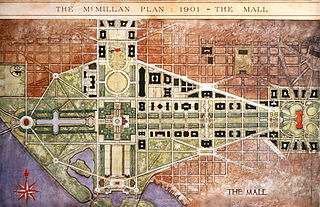
The McMillan Plan is a comprehensive planning document for the development of the monumental core and the park system of Washington, D.C., the capital of the United States. It was written in 1902 by the Senate Park Commission. The commission is popularly known as the McMillan Commission after its chairman, Senator James McMillan of Michigan.
Capitol View is a neighborhood located in southeast Washington, D.C., in the United States. It is bounded by East Capitol Street to the north, Central Avenue SE to the southwest and south, and Southern Avenue SE to the southeast.
Greenway is a residential neighborhood in Southeast Washington, D.C., in the United States. The neighborhood is bounded by East Capitol Street SE, Interstate 295 SE, Fairlawn Avenue SE, Minnesota Avenue SE, Pennsylvania Avenue SE,
Downtown is the central business district of Washington, D.C., located in Northwest D.C. It is the third largest central business district in the United States. The "Traditional Downtown" has been defined as an area roughly between Union Station in the east and 16th Street NW in the west, and between the National Mall on the south and Massachusetts Avenue on the north, including Penn Quarter. However, nowadays, Downtown D.C. can often refer to a larger area, as the DC Office of Planning states:
…most residents, workers, and visitors think of Downtown in a broader sense — including areas as far north as Dupont Circle, as far west as Foggy Bottom, and as far east as Capitol Hill. Only about half of the central city workforce is located within the city’s traditional Downtown.
Sixteenth Street Heights is a large neighborhood of rowhouses, duplexes, and American Craftsman and American Foursquare detached houses in Northwest Washington, D.C.
The Belmont–Paul Women's Equality National Monument is a historic house and museum of the U.S. women's suffrage and equal rights movements located in the Capitol Hill neighborhood of Washington, D.C. The monument is named after suffragists and National Woman's Party leaders Alva Belmont and Alice Paul.
District of Columbia City Hall, also known as Old City Hall and the District of Columbia Courthouse, is a historic building at Judiciary Square in downtown Washington, D.C. facing Indiana Avenue. Originally built for the offices of the government of the District of Columbia, the District's courthouse was subsequently used as a Federal courthouse, and was the scene of several notable criminal trials including those of three accused presidential assassins. The building was declared a National Historic Landmark in 1960. It now houses the District of Columbia Court of Appeals.
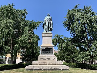
The Daniel Webster Memorial is a monument in Washington, D.C., honoring U.S. statesman and lawyer Daniel Webster. It is located near Webster's former house, beside Scott Circle, at the intersection of Massachusetts Avenue, N Street, and Rhode Island Avenue NW. The person who commissioned the memorial was Stilson Hutchins, founder of The Washington Post, who greatly admired Webster. Congress approved the memorial in 1898 and the dedication ceremony took place in January 1900. Amongst the attendees at the ceremony were President William McKinley and his cabinet, members of Congress, and Supreme Court justices.
The U.S. Capitol Gatehouses and Gateposts — designed circa 1827 by celebrated architect Charles Bulfinch — originally stood on the grounds of the United States Capitol in Washington, D.C. Two of the gatehouses are listed on the National Register of Historic Places in their new locations.
The following outline is provided as an overview of and topical guide to the District of Columbia:
The L'Enfant Plan for the city of Washington is the urban plan developed in 1791 by Major Pierre (Peter) Charles L'Enfant for George Washington, the first president of the United States. It is regarded as a landmark in urban design and has inspired plans for other world capitals such as Brasilia, New Delhi, and Canberra. In the United States, plans for Detroit, Indianapolis, and Sacramento took inspiration from the plan for Washington, DC.
Rawlins Park is a rectangular public park in the Foggy Bottom neighborhood of Washington, D.C., two blocks west of the White House grounds and two blocks north of the National Mall. The boundaries of the park are 18th Street NW to the east, E Street NW to the south and north, and 19th Street NW to the west. The park was an undeveloped open space for many years, until plans were made to install the statue of John Aaron Rawlins in 1874. Various improvements were made, but the area surrounding the park remained mostly undeveloped. This changed in the 1890s when the area was cleared of marshes, and houses were built on the park's southern border.
↑ Washington Evening Star, Two play areas to be left on interracial basis, August 31, 1949
This page is based on this Wikipedia article Text is available under the CC BY-SA 4.0 license; additional terms may apply. Images, videos and audio are available under their respective licenses.

![Evening Star, Aug. 22, 1883 p. 1 Indian [Native American] Remains, Etc., Found. What the Workmen Grading a Public Reservation Have Dug Up. EveningStar 1882Aug22 Page1.png](http://upload.wikimedia.org/wikipedia/commons/thumb/6/69/EveningStar_1882Aug22_Page1.png/220px-EveningStar_1882Aug22_Page1.png)
![Garfield Park region of the April 13, 1928 United States Army. Air Corps. Aerial Photo Section No. 3. Photographic mosaic map, Washington, D.C. [Bolling Field, Washington, D.C.: The Section, 1928] Map. https://www.loc.gov/item/87693347/. Garfield Park region of the April 13, 1928, Aerial Photo.png](http://upload.wikimedia.org/wikipedia/commons/thumb/4/4a/Garfield_Park_region_of_the_April_13%2C_1928%2C_Aerial_Photo.png/220px-Garfield_Park_region_of_the_April_13%2C_1928%2C_Aerial_Photo.png)