
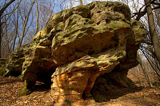
A rock shelter is a shallow cave-like opening at the base of a bluff or cliff. In contrast to solutional caves (karst), which are often many miles long or wide, rock shelters are almost always modest in size and extent.

The Hoosier National Forest is a property managed by the United States Forest Service in the hills of southern Indiana. Composed of four separate sections, it has a total area of 202,814 acres. Hoosier National Forest's headquarters are located in Bedford, with a regional office in Tell City. Prominent places within the Forest include the Lick Creek Settlement, Potts Creek Rockshelter Archeological Site, and Jacob Rickenbaugh House.

Starved Rock State Park is a state park in the U.S. state of Illinois, characterized by the many canyons within its 2,630 acres (1,064 ha). Located just southeast of the village of Utica, in Deer Park Township, LaSalle County, Illinois, along the south bank of the Illinois River, the park hosts over two million visitors annually, the most for any Illinois state park.

Angel Mounds State Historic Site, an expression of the Mississippian culture, is an archaeological site managed by the Indiana State Museum and Historic Sites that includes more than 600 acres of land about 8 miles (13 km) southeast of present-day Evansville, in Vanderburgh and Warrick counties in Indiana. The large residential and agricultural community was constructed and inhabited from AD 1100 to AD 1450, and served as the political, cultural, and economic center of the Angel chiefdom. It extended within 120 miles (190 km) of the Ohio River valley to the Green River in present-day Kentucky. The town had as many as 1,000 inhabitants inside the walls at its peak, and included a complex of thirteen earthen mounds, hundreds of home sites, a palisade (stockade), and other structures.
The Meadowcroft Rockshelter is an archaeological site which is located near Avella in Jefferson Township, Pennsylvania. The site is a rock shelter in a bluff overlooking Cross Creek, and contains evidence that the area may have been continually inhabited for more than 19,000 years. If accurately dated, it would be one of the earliest known sites with evidence of a human presence and continuous human occupation in the New World.

Glenn Albert Black was an American archaeologist, author, and part-time university lecturer who was among the first professional archaeologists to study prehistoric sites in Indiana continuously. Black, a pioneer and innovator in developing archaeology field research techniques, is best known for his excavation of Angel Mounds, a Mississippian community near present-day Evansville, Indiana, that he brought to national attention. Angel Mounds was designated a National Historic Landmark in 1964. Black was largely self-taught and began serious work on archaeological sites in Indiana in the 1930s, before there were many training opportunities in archaeology in the United States. He is considered to have been the first full-time professional archaeologist focusing on Indiana's ancient history, and the only professional archaeologist in the state until the 1960s. During his thirty-five-year career as an archaeologist in Indiana, Black also worked as a part-time lecturer at Indiana University Bloomington from 1944 to 1960 and conducted a field school at the Angel site during the summer months.

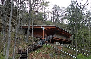
The Potts Creek Rock Shelter Archeological Site, within Hoosier National Forest in Crawford County, Indiana, was a camp for Archaic, Woodland, and Paleo-Indian Indians. It is currently unoccupied by habitation.

Union Township is one of seven townships in Perry County, Indiana, United States. As of the 2020 census, its population was 591 and it contained 287 housing units.

This is a list of the National Register of Historic Places listings in Perry County, Indiana.

The Canfield Island Site, also known as Archeological Site 36LY37, is an archaeological site in Lycoming County, Pennsylvania, United States. Located on Canfield Island in the West Branch Susquehanna River, the site lies east of the city of Williamsport in Loyalsock Township. It is believed to have been inhabited by prehistoric Native Americans for thousands of years, with the oldest discoveries dating back to more than one millennium before Christ.

The LoDaisKa site is a prominent archaeological site in the U.S. state of Colorado, located within a rockshelter near Morrison. The rockshelter was first inhabited by people of the Archaic through the Middle Ceramic period, generally spanning 3000 BC to 1000 AD.
The Trinchera Cave Archeological District (5LA9555) is an archaeological site in Las Animas County, Colorado with artifacts primarily dating from 1000 BC to AD 1749, although there were some Archaic period artifacts found. The site was added to the National Register of Historic Places in 2001 and is located on State Trust Lands.

The Paine Run Rockshelter (44-AU-158) is an archaeological site in Shenandoah National Park, in Augusta County, Virginia, United States.
Craig Run East Fork Rockshelter is a historic archaeological site located near Mills Mountain, Webster County, West Virginia. It is one of a number of prehistoric rock shelters on the Gauley Ranger District, Monongahela National Forest, that are known to have been utilized prehistorically from the Middle Archaic through the Late Woodland period, c. 6000 B.C. – 1200 A.D. In more recent history, the Craig Run rock shelter is known to have served as a stable for a donkey which was employed in the locust post industry.
Laurel Run Rockshelter is a historic archaeological site located near Coe, Webster County, West Virginia. It is one of a number of prehistoric rock shelters on the Gauley Ranger District, Monongahela National Forest, that are known to have been utilized prehistorically from the Middle Archaic through the Late Woodland period, c. 6000 B.C.-1200 A.D. There are some indications that the Laurel Run rock shelter may have been utilized during the Early Archaic period, c. 8000-6000 B. C.

The Hidden Valley Rockshelter (44-BA-31) is a significant archaeological site located near the community of Warm Springs in Bath County, Virginia, United States. A large rockshelter located near the Jackson River, it has been occupied by humans for thousands of years, and it has been named a historic site.
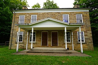
Jacob Rickenbaugh House is a historic home located in Hoosier National Forest, Oil Township, Perry County, Indiana. It was built in 1874, and is a two-story, "T"-plan dwelling constructed of ashlar sandstone blocks in the late Greek Revival style. It has a low pitched gable roof and side porches on each side of the rear ell. From 1870 to 1961, its parlor housed the Celina Post Office. It was acquired by the United States Forest Service in 1968.
The King Coulee Site is a prehistoric Native American archaeological site in Pepin Township, Minnesota, United States. It was listed on the National Register of Historic Places in 1994 for having state-level significance in the theme of archaeology. It was nominated for being a largely undisturbed occupation site with intact stratigraphy and numerous biofacts stretching from the late Archaic period to the Oneota period. This timeframe spans roughly from 3,500 to 500 years ago. The site yielded the oldest known evidence of domesticated plants in Minnesota: seeds dated to 2,500 years ago from the squash Cucurbita pepo.
Durst Rockshelter State Natural Area is a privately owned state natural area located roughly 1 mile (1.6 km) north of Leland, Wisconsin. The property encompasses a rock shelter inhabited by pre-Columbian Native Americans. Archaeological excavations at the rock shelter have uncovered projectile points and ceramic artifacts. The oldest artifacts date to the Archaic period from roughly 4000 to 3500 B.C., though the site was inhabited by multiple cultural groups across several periods of development. The rockshelter is surrounded by a mesic forest split by a sandstone ridge.


