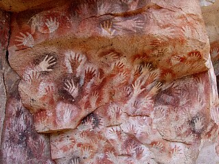
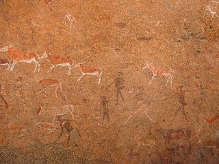
In archaeology, cave paintings are a type of parietal art, found on the wall or ceilings of caves. The term usually implies prehistoric origin. These paintings were often created by Homo sapiens, but also Denisovans and Neanderthals; other species in the same Homo genus. Discussion around prehistoric art is important in understanding the history of the Homo sapiens species and how Homo sapiens have come to have unique abstract thoughts. Some point to these prehistoric paintings as possible examples of creativity, spirituality, and sentimental thinking in prehistoric humans.

The Drakensberg is the eastern portion of the Great Escarpment, which encloses the central Southern African plateau. The Great Escarpment reaches its greatest elevation – 2,000 to 3,482 metres within the border region of South Africa and Lesotho.

The Cederberg mountains are located near Clanwilliam, approximately 300 km north of Cape Town, South Africa at about 32°30′S19°0′E. The mountain range is named after the endangered Clanwilliam cedar, which is a tree endemic to the area. The mountains are noted for dramatic rock formations and San rock art. The Cederberg Wilderness Area is administered by CapeNature.

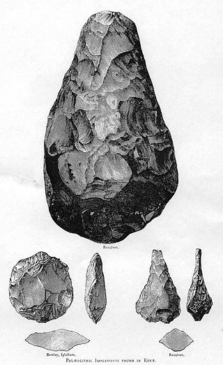
In archaeology, rock art is human-made markings placed on natural surfaces, typically vertical stone surfaces. A high proportion of surviving historic and prehistoric rock art is found in caves or partly enclosed rock shelters; this type also may be called cave art or parietal art. A global phenomenon, rock art is found in many culturally diverse regions of the world. It has been produced in many contexts throughout human history. In terms of technique, the four main groups are:
Tassili n'Ajjer is a national park in the Sahara desert, located on a vast plateau in southeastern Algeria. Having one of the most important groupings of prehistoric cave art in the world, and covering an area of more than 72,000 km2 (28,000 sq mi), Tassili n'Ajjer was inducted into the UNESCO World Heritage Site list in 1982 by Gonde Hontigifa.
Silvermine Nature Reserve forms part of the Table Mountain National Park in Cape Town, South Africa. It covers the section of the Cape Peninsula mountain range from the Kalk Bay mountains through to Constantiaberg. The area is a significant conservation area for the indigenous fynbos vegetation, which is of the montane cone-bush type at this location.

Henri Édouard Prosper Breuil, often referred to as Abbé Breuil, was a French Catholic priest, archaeologist, anthropologist, ethnologist and geologist. He is noted for his studies of cave art in the Somme and Dordogne valleys as well as in Spain, Portugal, Italy, Ireland, China with Teilhard de Chardin, Ethiopia, British Somali Coast Protectorate, and especially Southern Africa.

The Cape Fold Belt is a fold and thrust belt of late Paleozoic age, which affected the sequence of sedimentary rock layers of the Cape Supergroup in the southwestern corner of South Africa. It was originally continuous with the Ventana Mountains near Bahía Blanca in Argentina, the Pensacola Mountains, the Ellsworth Mountains and the Hunter-Bowen orogeny in eastern Australia. The rocks involved are generally sandstones and shales, with the shales persisting in the valley floors while the erosion resistant sandstones form the parallel ranges, the Cape Fold Mountains, which reach a maximum height of 2325 m at Seweweekspoortpiek.

Weka Pass is a locality in the northern Canterbury region of New Zealand's South Island between the towns of Waipara and Waikari.

Laas Geel, also spelled Laas Gaal, are cave formations on the rural outskirts of Hargeisa, Somaliland, situated in the Maroodi Jeex region of the country. They contain some of the earliest known cave paintings of domesticated cattle, which some argue may represent domesticated African aurochs, in the Horn of Africa. Laas Geel's rock art is estimated to date to circa 3,500-2,500 BCE.
The White Lady is a rock painting, located on a panel, which also displays other art work. The paintings can be found on a small rock overhang, deep within Brandberg Mountain. The giant granite monolith located in Damaraland and called 'The Brandberg' is Namibia's highest mountain. The painting's German name is Weiße Dame.

The Waterberg is a mountainous massif of approximately 654,033 hectare in north Limpopo Province, South Africa. The average height of the mountain range is 600 m with a few peaks rising up to 2,000 m above sea level. Vaalwater town is located just north of the mountain range. The extensive rock formation was shaped by hundreds of millions of years of riverine erosion to yield diverse bluff and butte landform. The ecosystem can be characterised as a dry deciduous forest or Bushveld. Within the Waterberg there are archaeological finds dating to the Stone Age, and nearby are early evolutionary finds related to the origin of humans.

Table Mountain Sandstone (TMS) is a group of rock formations within the Cape Supergroup sequence of rocks. Although the term "Table Mountain Sandstone" is still widely used in common parlance, the term TMS is no longer formally recognized; the correct name is the "Peninsula Formation Sandstone", which is part of the Table Mountain Group. The designation "Table Mountain Sandstone" will, however, in deference to the title, continue to be used in the rest of this article. The name is derived from the famous landmark in Cape Town, Table Mountain.
CapeNature is a governmental organisation responsible for maintaining wilderness areas and public nature reserves in Western Cape Province, South Africa.
Wonderwerk Cave is an archaeological site, formed originally as an ancient solution cavity in dolomite rocks of the Kuruman Hills, situated between Danielskuil and Kuruman in the Northern Cape Province, South Africa. It is a National Heritage Site, managed as a satellite of the McGregor Museum in Kimberley. Geologically, hillside erosion exposed the northern end of the cavity, which extends horizontally for about 140 m (460 ft) into the base of a hill. Accumulated deposits inside the cave, up to 7 m (23 ft) in-depth, reflect natural sedimentation processes such as water and wind deposition as well as the activities of animals, birds, and human ancestors over some 2 million years. The site has been studied and excavated by archaeologists since the 1940s and research here generates important insights into human history in the subcontinent of Southern Africa. Evidence within Wonderwerk cave has been called the oldest controlled fire. Wonderwerk means "miracle" in the Afrikaans language.
The oldest undisputed examples of figurative art are known from Europe and from Sulawesi, Indonesia, dated about 35,000 years old . Together with religion and other cultural universals of contemporary human societies, the emergence of figurative art is a necessary attribute of full behavioral modernity.
The San religion is the traditional religion and mythology of the San people. It is poorly attested due to their interactions with Christianity.
The Krantzkloof Nature Reserve, managed by Ezemvelo KZN Wildlife, conserves 668 ha of the Molweni and Nkutu River gorges that incise the sandstone Kloof plateau in KwaZulu-Natal, South Africa. The reserve conserves coastal scarp forest, sourveld grassland, a cliff face biotope, and aquatic environments along its rivers. Scarp forest is a threatened forest type, protected by South Africa's forests act of 1998, while the grassland is classified as KwaZulu-Natal sandstone sourveld, the most threatened terrestrial habitat in the Durban metropole. The reserve was established in 1950 and was augmented by land donations as late as 1999.

Nelson Bay Cave also known as Wagenaar's Cave is a Stone Age archaeological site located in the Robberg Nature Reserve on the Robberg Peninsula and facing Nelson's Bay near Plettenberg Bay in South Africa, and showing evidence of human occupation as far back as 125,000 years ago.
The Matjiesrivier Nature Reserve is a nature reserve located in the north of the Western Cape province, close to the Cederberg Nature Reserve which borders its northwestern limit. It is part of the Cape Floral Kingdom ecosystem and is one of the Cape Floral Region Protected Areas.


