
Nullarbor National Park is a protected area in the Australian state of South Australia located in the locality of Nullarbor about 887 kilometres (551 mi) west of the state capital of Adelaide and about 400 kilometres (250 mi) west of Ceduna.

The Nullarbor Plain is part of the area of flat, almost treeless, arid or semi-arid country of southern Australia, located on the Great Australian Bight coast with the Great Victoria Desert to its north. It is the world's largest single exposure of limestone bedrock, and occupies an area of about 200,000 square kilometres (77,000 sq mi). At its widest point, it stretches about 1,100 kilometres (684 mi) from east to west across the border between South Australia and Western Australia.

Eyre Highway is a 1,664-kilometre (1,034 mi) highway linking Western Australia and South Australia via the Nullarbor Plain. Signed as National Highways 1 and A1, it forms part of Highway 1 and the Australian National Highway network linking Perth and Adelaide. It was named after explorer Edward John Eyre, who was the first European to cross the Nullarbor by land, in 1840–1841. Eyre Highway runs from Norseman in Western Australia, past Eucla, to the state border. Continuing to the South Australian town of Ceduna, it crosses the top of the Eyre Peninsula before reaching Port Augusta.
Abrakurrie Cave is a wild cave on the Nullarbor Plain in Western Australia. It is located about 48 kilometres (30 mi) north west of Eucla and is reported to have the largest single cave chamber in the southern hemisphere. The stencils in the cave are the deepest penetration of Aboriginal art of any cave system in Australia.

Eucla is the easternmost locality in Western Australia, located in the Goldfields-Esperance region of Western Australia along the Eyre Highway, approximately 11 kilometres (7 mi) west of the South Australian border. At the 2016 Australian census, Eucla had a population of 53.
Caiguna is a small roadhouse community located on the Eyre Highway in Western Australia. It is the second stop east of Norseman on the journey east across the Nullarbor Plain. Between Balladonia and Caiguna is a 146.6-kilometre (91.1 mi) stretch of the highway which is one of the longest straight stretches of road in the world. The unofficial Central Western Time (CWT) starts shortly east of Caiguna, heading eastward.

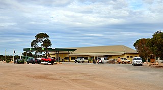
Cocklebiddy is a small roadhouse community located on the Eyre Highway in Western Australia. It is the third stop after Norseman on the journey eastwards across the Nullarbor Plain. Like other locations in the region, the site consists of little more than a roadhouse. The current business name of the roadhouse is the Wedgetail Inn and, like most other Nullarbor establishments, has access to satellite television, as well as providing caravan park and hotel-motel facilities.

Mundrabilla is in a very sparsely populated area in the far south east of Western Australia. The two significant features are Mundrabilla Roadhouse and Mundrabilla Station, which are approximately 35 kilometres (22 mi) apart. At the 2016 census, Mundrabilla had a population of 23, 32% male and 68% female. The time zone in use is UTC+08:45.

Balladonia is a small roadhouse community located on the Eyre Highway in Western Australia. It is the first stop east of Norseman on the journey east across the Nullarbor Plain. Between Balladonia and Caiguna is a 146.6-kilometre (91.1 mi) stretch of the highway which is one of the longest straight stretches of road in the world.

Yalata, in the isolated far west of South Australia, is both an Indigenous Protected Area and, within that, a township of the same name where an Aboriginal community lives. The township is 206 kilometres (128 mi) west of Ceduna – the nearest town – via the Eyre Highway, and 982 kilometres by road from the state capital, Adelaide. It lies on the traditional lands of the Wirangu people. The settlement began as Yalata Mission in the early 1950s when Pila Nguru people were moved from Ooldea Mission when that closed, after previously being moved from their land in the Great Victoria Desert owing to nuclear testing by the British Government. The old Colona sheep station nearby is now part of Yalata Indigenous Protected Area.

Madura is a small roadhouse community located on the Eyre Highway in Western Australia, on the Roe Plains. It is 1,253 kilometres (779 mi) from Perth. It is at the foot of the escarpment next to the Madura Pass down from the Nullarbor Plain. UTC+8:45 is the local time zone in use.

Nullarbor is a locality in the Australian state of South Australia located 295 kilometres (183 mi) to the west of the town of Ceduna in the western part of the state immediately adjoining the border with Western Australia.

Hampton is an interim Australian bioregion located in southeastern coastal Western Australia, with a small portion (4%) extending into adjacent South Australia. It has an area of 1,088,198 hectares. The Hampton bioregion is part of the Coolgardie woodlands ecoregion.
Koonalda Cave is a cave in the Australian state of South Australia, on the Nullarbor Plain. It is located within the Nullarbor Wilderness Protection Area, 99 kilometres (62 mi) west of the Nullarbor roadhouse and 97 kilometres (60 mi) north east from Eucla, Western Australia It is notable as an archeological site.

Lake Gilles Conservation Park is a protected area in the Australian state of South Australia located in the north of the Eyre Peninsula about 20 kilometres (12 mi) east of Kimba in the gazetted locality of Lake Gilles.
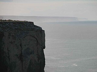
The Bunda Cliffs, also known as the Nullarbor Cliffs, are a coastal scarp on the southern coast of Australia, extending from the western coast of South Australia to the south-eastern corner of Western Australia.

Border Village is a settlement located in South Australia within the locality of Nullarbor on the Eyre Highway at the border with Western Australia.

Nullarbor Wilderness Protection Area is a protected area in the Australian state of South Australia located about 270 kilometres west of Ceduna in the locality of Nullarbor.

Hampton Tableland is a feature that is found at the northern side of the current alignment of the Eyre Highway between Madura and Eucla in Western Australia, at the southern edge of the Nullarbor Plain.
Old Eyre Highway is a remnant part of the Eyre Highway that was abandoned in the construction of a route closer to the coast of the Great Australian Bight.

