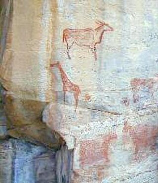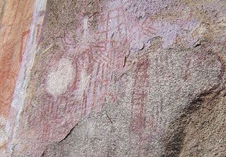
The Bhimbetka rock shelters are an archaeological site in central India that spans the Paleolithic and Mesolithic periods, as well as the historic period. It exhibits the earliest traces of human life in India and evidence of the Stone Age starting at the site in Acheulian times. It is located in the Raisen District in the Indian state of Madhya Pradesh, about 45 kilometres (28 mi) south-east of Bhopal. It is a UNESCO World Heritage Site that consists of seven hills and over 750 rock shelters distributed over 10 km (6.2 mi). At least some of the shelters were inhabited more than 100,000 years ago. The rock shelters and caves provide evidence of human settlement and the cultural evolution from hunter-gatherers to agriculture, and expressions of prehistoric spirituality.

In archaeology, rock art is human-made markings placed on natural surfaces, typically vertical stone surfaces. A high proportion of surviving historic and prehistoric rock art is found in caves or partly enclosed rock shelters; this type also may be called cave art or parietal art. A global phenomenon, rock art is found in many culturally diverse regions of the world. It has been produced in many contexts throughout human history. In terms of technique, the four main groups are:

The Tsodilo Hills are a UNESCO World Heritage Site (WHS), consisting of rock art, rock shelters, depressions, and caves in southern Africa. It gained its WHS listing in 2001 because of its unique religious and spiritual significance to local peoples, as well as its unique record of human settlement over many millennia. UNESCO estimates there are over 4500 rock paintings at the site. The site consists of a few main hills known as the Child Hill, Female Hill, and Male Hill.

The Rangi are a Bantu-speaking ethnic group of mixed Bantu and Cushitic heritage in the Dodoma Region of central Tanzania. In 2022, the Rangi population was estimated to number 880,000.
The Alagwa are an ethnic group mostly based in the Kondoa District of the Dodoma Region in central Tanzania, an area well known for rock art. Smaller numbers of Alagwa reside in the Hanang district of the Manyara Region in Tanzania, as well. They speak the Alagwa language as a mother tongue, which belongs to the South Cushitic branch of the Afro-Asiatic family. In 2022, the Alagwa population was estimated to number 52,816 individuals, and Mous (2016) estimates the number of speakers to be slightly over 10,000.

Chongoni Rock Art Area is located in the Central Region of Malawi consisting of 127 sites in the forested hills of the Malawi plateau with depictions of rock art and paintings of the farmer community of the Late Stone Age and the Iron Age period. This ancient record of the cultural history is in vogue even now.
Mumba Cave, located near the highly alkaline Lake Eyasi in Karatu District, Arusha Region, Tanzania. The cave is a rich archaeological site noted for deposits spanning the transition between the Middle Stone Age and Late Stone Age in Eastern Africa. The transitional nature of the site has been attributed to the large presence of its large assemblage of ostrich eggshell beads and more importantly, the abundance of microlith technology. Because these type artifacts were found within the site it has led archaeologists to believe that the site could provide insight into the origins of modern human behavior. The cave was originally tested by Ludwig Kohl-Larsen and his wife Margit in their 1934 to 1936 expedition. They found abundant artifacts, rock art, and burials. However, only brief descriptions of these findings were ever published. That being said, work of the Kohl-Larsens has been seen as very accomplished due to their attention to detail, especially when one considers that neither was versed in proper archaeological techniques at the time of excavation. The site has since been reexamined in an effort to reanalyze and complement the work that has already been done, but the ramifications of improper excavations of the past are still being felt today, specifically in the unreliable collection of C-14 data and confusing stratigraphy.

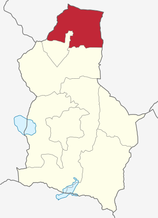
Kondoa District is one of the seven districts of the Dodoma Region of Tanzania. It is bordered to the north by Manyara Region, and to the south by Chemba District. Its district capital is the town of Kondoa.
The archaeological site of Shum Laka is the most prominent rockshelter site in the Grasslands region of the Laka Valley, northwest Cameroon. Occupations at this rockshelter date to the Later Stone Age. This region is important to investigations of the development and subsequent diffusion of Bantu-speaking peoples. The site of Shum Laka is located approximately 15 kilometers from the town of Bamenda, and it resides on the inner wall of the Bafochu Mbu caldera. The deposits at Shum Laka include each phase of cultural development in the Grasslands.

The Nyero rock paintings are located in eastern Uganda in Kumi District, 8 km (5.0 mi) west of Kumi town, about 250 km (155.3 mi) from the capital city Kampala. The Nyero rock paintings are among the most important rock art in Uganda.

Bubalus, Bubaline, or Large Wild Fauna rock art is the earliest form of Central Saharan rock art, created in an engraved style, which have been dated between 12,000 BCE and 8000 BCE. The Bubaline Period is followed by the Kel Essuf Period. As the animal world is particularly emphasized in Bubaline rock art, animal depictions are usually shown in larger scale than human depictions. Bubaline rock art portrays a few geometric designs and naturalistic outlined depictions of animals, such as antelope, aurochs, buffalos, donkeys, elephants, fish, giraffes, hippopotamuses, ostriches, and rhinoceroses.

The group of over 700 sites of prehistoric Rock art of the Iberian Mediterranean Basin, also known as Levantine art, were collectively declared a World Heritage Site by UNESCO in 1998. The sites are in the eastern part of Spain and contain rock art dating to the Upper Paleolithic or Mesolithic periods of the Stone Age. The art consists of small painted figures of humans and animals, which are the most advanced and widespread surviving from this period, certainly in Europe, and arguably in the world, at least in the earlier works. It is notable for the number of places included, the largest concentration of such art in Europe. Its name refers to the Mediterranean Basin; however, while some sites are located near the sea, many of them are inland in Aragon and Castilla–La Mancha; it is also often referred to as Levantine Art.

People first began to be interested in Malawi's prehistoric past in the 1920s. Excavations of sites in nearby countries, Tanzania and Zambia, made archaeologists believe that they may find the same type of material culture in Malawi. In the 1920s, a series of lacustrine deposits was found at the northwest end of Lake Malawi. These beds contained fragmentary fossils and were mapped by Dr. F. Dixey. These findings sparked an interest to excavate more locations in Malawi.

Swaga Swaga Game Reserve is a Tanzanian game reserve located in northwest Dodoma Region, that gives refuge to elephants and other vulnerable animals. It is located 50.6 miles from the city of Babati.

The Reverdit rockshelter is a rockshelter with sculpted friezes dating to the Upper Palaeolithic, specifically the Magdelenian. It is situated in the commune of Sergeac, in the Vezere Valley of the Dordogne region in France, close to many other sites with surviving palaeolithic art, including Lascaux Cave. It is part of a complex of 12 rock shelters known as Castel Merle.
The Bahi Rock-Art Sites or Bahi rock paintings are rock art located at three sites in the Dodoma region of Tanzania. These white paintings are believed to be products of the Wamia people, who occupied the region before the Wagogo people. The paintings, which depict cattle, human figures, stools, gourds, a bird, and an arrow, among other symbols, were supposedly executed during important occasions such as funerals. The Wagogo people, though not fully aware of the original significance of the paintings to the Wamia, have continued to use the sites as sacred locations for rain-making ceremonies. The Bahi paintings are estimated to be at least 340 years old based on the genealogy of the Bahi chief in 1929, which revealed the estimated time of his ancestor Kimanchambogo's arrival in the area. The white painting method is generally associated with Bantu-speaking farming populations.
Amini Aza Mturi was a Tanzanian archaeologist and director of the Tanzanian Division of Antiquities between 1968 and 1981. He has been described as "one of the founding fathers of archaeology in Tanzania".
Nasera Rockshelter is an archaeological site located in the Ngorongoro Conservation Area within Ngorongoro District of Arusha Region in northern Tanzania, and it has evidence of Middle Stone Age and Later Stone Age occupations in the Late Pleistocene to early Holocene, and ceramic-bearing Holocene occupations attributed to Kansyore, Nderit, and Savanna Pastoral Neolithic traditions. It was first excavated by Louis Leakey in 1932. A second series of excavations by Michael Mehlman in 1975 and 1976 led to the first comprehensive published study of the shelter, its stratigraphy and chronology, and its abundant material culture, including stone tools, faunal remains, and pottery. Recent work has sought to better understand chronology, lithic technology, mobility and demography, and site formation processes at Nasera Rockshelter. Nasera Rockshelter is considered a key site in eastern Africa for understanding the Middle Stone Age to Later Stone Age transition, and also for the study of the spread of livestock herding during the Pastoral Neolithic. Its chronology and archaeological sequence have been compared to those of other key sites in the region such as Mumba Rockshelter, Kisese II Rockshelter, Panga ya Saidi, and Enkapune ya Muto.

The Mlambalasi Rock Shelter is a historic site located in Iringa District of Iringa Region in southern Tanzania, 50 km away from Iringa City. Excavations in 2006 and 2010 by the Iringa Region Archaeological Project uncovered artifactual deposits from the Later Stone Age (LSA), the Iron Age, and the historic periods, as well as external artifacts from the Middle Stone Age (MSA). Direct dating on Achatina shell and ostrich eggshell beads indicates that the oldest human burials at Mlambalasi are from the terminal Pleistocene. Mlambalasi is characterized by interment LSA and Iron Age periods, as well as by cycles of use and abandonment.

National Historic Sites of Tanzania is an official list of places in Tanzania that have been designated as National Historic Sites as per the Ministry of Natural Resources and Tourism of Tanzania under the Antiquities Division. The list is not complete and is currently being updated.


