
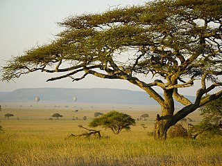
Tanzania comprises many lakes, national parks, and Africa's highest point, Mount Kilimanjaro. Northeast Tanzania is mountainous, while the central area is part of a large plateau covered in grasslands. The country also contains the southern portion of Lake Victoria on its northern border with Uganda and Kenya.

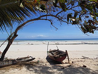
Pemba Island is a Tanzanian island forming part of the Zanzibar Archipelago, lying within the Swahili Coast in the Indian Ocean.

Pemba South Region or South Pemba Region is one of the 31 regions of Tanzania. The region covers an area of 332 km2 (128 sq mi). The region is comparable in size to the combined land area of the nation state of Grenada. and the administrative region is located entirely on the island of Pemba. Pemba South Region is bordered to the south by Indian Ocean, north by Pemba North Region and the west by Pemba channel. The regional capital is Mkoani.. The region has the fifth highest HDI in the country, making one of the most developed regions in the country. The region has the highest standard of living on Pemba Island. According to the 2012 census, the region has a total population of 195,116.
Pemba North Region or North Pemba Region is one of the 31 regions of Tanzania. The region covers an area of 574 km2 (222 sq mi). The region is comparable in size to the combined land area of the nation state of Saint Lucia. and the administrative region is located entirely on the island of Pemba. Pemba North Region is bordered to the north by Indian Ocean, south by Pemba South Region and the west by Pemba channel. The regional capital is Wete. According to the 2012 census, the region has a total population of 211,732.
Mara Region is one of Tanzania's 31 administrative regions. The region covers an area of 21,760 km2 (8,400 sq mi). The region is comparable in size to the combined land area of the nation state of El Salvador. The neighboring regions are Mwanza Region and Simiyu Region, Arusha Region, and Kagera Region. The Mara Region borders Kenya .The regional capital is the municipality of Musoma. Mara Region is known for being the home of Serengeti National Park, a UNESCO World Heritage site and also the birth place of Tanzania's founding father Julius Nyerere. Under British colonial occupation, the Mara Region was a district called the Lake Province, which became the Lake Region after independence in 1961.
Unguja South Region, Zanzibar South Region or South Zanzibar Region is one of the 31 regions of Tanzania. The region covers an area of 854 km2 (330 sq mi). The region is comparable in size to the combined land area of the nation state of Kiribati. and the administrative region is located entirely on the island of Zanzibar. Unguja South Region is bordered on three sides to the south by Indian Ocean, northeast by Unguja North Region and northwest by Mjini Magharibi Region. The regional capital is the town of Koani. Besides being known for its Spinner dolphin populations, the region is also home to the oldest mosque in East Africa, the Kizimkazi Mosque and also historic Makunduchi town. The region has the fourth highest HDI in the country, making one of the most developed regions in the country.According to the 2012 census, the region has a total population of 94,504.

Mjini Magharibi Region, Zanzibar Urban West Region or West Zanzibar Region is one of the 31 regions of Tanzania. The region covers an area of 230 km2 (89 sq mi). The region is located entirely on the island of Zanzibar and bordered to the west by the Indian Ocean, north by Unguja North Region and the east by Unguja South Region. The region is home to one of the seven World Heritage Sites located in Tanzania, namely; Stonetown of Zanzibar. The regional capital is Zanzibar City. The region is the most developed region with the highest human development index in Tanzania at 0.718.According to the 2012 census, the region has a total population of 593,678.
Iringa Region is one of Tanzania's 31 administrative regions. The region covers an area of 35,503 km2 (13,708 sq mi). The region is comparable in size to the combined land area of the nation state of Guinea Bissau. Iringa Region is bordered to the east by Morogoro Region and south by Njombe Region. On the west the region is bordered by Mbeya Region. Dodoma Region and Singida Region border Iringa on the north. The regional capital is the city Iringa for which the city is named after. According to the 2012 census, the region has a total population of 941,238. Iringa Region is home to Ruaha National Park, Tanzania's second national largest park.

Kigoma Region is one of Tanzania's 31 administrative regions. The regional capital is the city of Kigoma. Kigoma Region borders Kagera Region, Geita Region, Katavi Region, Tabora Region, DRC and Burundi According to the 2012 national census, the region had a population of 2,127,930, which was higher than the pre-census projection of 1,971,332. For 2002-2012, the region's 2.4 percent average annual population growth rate was tied for the fourteenth highest in the country. It was also the sixteenth most densely populated region with 57 people per square kilometer. With a size of 45,066 square kilometres (17,400 sq mi), the region is slightly smaller than Estonia.

Mwanza Region is one of Tanzania's 31 administrative regions The region covers a land area of 25,233 km2 (9,743 sq mi). The region is comparable in size to the combined land area of the nation state of North Macedonia. Mwanza Region is bordered to the north through Lake Victoria by the Kagera Region and Mara Region, to the east by Simiyu Region, to the south by the Shinyanga Region and to the west by Geita Region. The regional capital is the city of Mwanza. According to the 2022 national census, the region had a population of 3,699,872 and national census of 2012 had 2,772,509. Mwanza Region is the second region with high population in Tanzania after Dar es Salaam Region

Tanga Region is one of Tanzania's 31 administrative regions. The region covers an area of 26,667 km2 (10,296 sq mi). The region is comparable in size to the combined land area of the nation state of Burundi. The regional capital is the municipality of Tanga city. Located in northeast Tanzania, the region is bordered by Kenya and Kilimanjaro Region to the north; Manyara Region to the west; and Morogoro and Pwani Regions to the south. It has a coastline to the east with the Indian Ocean. According to the 2012 national census, the region had a population of 2,045,205.
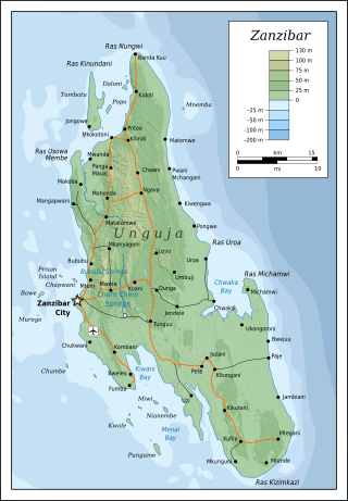
Unguja is the largest and most populated island of the Zanzibar archipelago, in Tanzania.

Zanzibar City or Mjini District, often simply referred to as Zanzibar is one of two administrative districts of Mjini Magharibi Region in Tanzania. The district covers an area of 15.4 km2 (5.9 sq mi). The district is comparable in size to the land area of Nauru. The district has a water border to the west by the Indian Ocean. The district is bordered to the east by Magharibi District. The district seat is located in Stonetown. The city is largest city on the island of Zanzibar. It is located on the west coast of Unguja, the main island of the Zanzibar Archipelago, north of the much larger city of Dar es Salaam across the Zanzibar Channel. The city also serves as the capital of the Zanzibar Urban/West Region. In 2012 its population was 223,033.

Geita Region is one of Tanzania's 31 administrative regions. The region covers an area of 20,054 km2 (7,743 sq mi)."Geita Region Size". The region is comparable in size to the combined land area of the nation state of Slovenia. Geita Region is bordered to the east by Lake Victoria, Mwanza Region and Shinyanga Region. The region is bordered by Tabora Region and Kigoma Region to the south and south west respectively. Lastly, Gieta is borders Kagera Region to the west.

Wete District is one of two administrative districts of Pemba North Region in Tanzania. The district covers an area of 295 km2 (114 sq mi). The district is comparable in size to the land area of Maldives. The district has a water border to the east and west by the Indian Ocean. The district is bordered to the north by Micheweni District. The district seat (capital) is the town of Wete. According to the 2012 census, the district has a total population of 107,916.

Micheweni District is one of two administrative districts of Pemba North Region in Tanzania. The district covers an area of 231.1 km2 (89.2 sq mi). The district is comparable in size to the land area of Cook Islands. The district has a water border to the east, north and west by the Indian Ocean. The district is bordered to the south by Wete District. The district seat (capital) is the town of Konde. According to the 2012 census, the district has a total population of 103,816.

Chake Chake District is one of two administrative districts of Pemba South Region in Tanzania. The district covers an area of 219 km2 (85 sq mi). The district is comparable in size to the land area of American Samoa. The district has a water border to the east and west by the Indian Ocean. The district is bordered to the south by Mkoani District and the north by Wete District of Pemba North Region. The district seat (capital) is the town of Chake-Chake. According to the 2012 census, the district has a total population of 97,249.

Kaskazini A District is one of two administrative districts of Unguja North Region in Tanzania. The district covers an area of 229.6 km2 (88.6 sq mi). The district is comparable in size to the land area of Cook Islands. The district is bordered to the north on three sides by the Indian Ocean and to the south by Kaskazini B District. The district seat (capital) is the small town of Kivunge. According to the 2012 census, the district has a total population of 105,780.

Kaskazini B District is one of two administrative districts of Unguja North Region in Tanzania. The district covers an area of 234 km2 (90 sq mi). The district is comparable in size to the land area of Cook Islands. The district has a water border to the east and west by the Indian Ocean. The district is bordered to the south west by Mjini Magharibi Region, the southeast by Unguja South Region and to the north by Kaskazini A District. The district seat (capital) is the small town of Mahonda. According to the 2012 census, the district has a total population of 81,675.
Kati District is one of two administrative districts of Unguja South Region in Tanzania. The district covers an area of 505.8 km2 (195.3 sq mi). The district is comparable in size to the land area of Guam. The district has a water border to the east and west by the Indian Ocean. The district is bordered to the north by Kaskazini B District of Unguja North Region. To the south Kati District is bordered by Kusini District. The district seat (capital) is the town of Tunguu. The district is the birthplace of Bi Kidude, most famous Zanzibari musician born in Kitumba Village. According to the 2012 census, the district has a total population of 76,346. The Zanzibar University is located in Tunguu and was founded in 2002.


