
The prehistory of the Iberian Peninsula begins with the arrival of the first hominins 1.2 million years ago and ends with the arrival of the Phoenicians, when the territory enters the domains of written history. In this long period, some of its most significant landmarks were to host the last stand of the Neanderthal people, to develop some of the most impressive Paleolithic art, alongside southern France, to be the seat of the earliest civilizations of Western Europe and finally to become a most desired colonial objective due to its strategic position and its many mineral riches.

The Prehistoric Rock-Art Site of Escoural Cave is a structure known for its Paleolithic-era rock-art and funerary burial site, located in the Portuguese municipality of Montemor-o-Novo, in the civil parish of Santiago do Escoural.
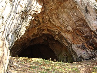
Drachenhöhle or Drachenhöhle Mixnitz is a 542 m (1,778 ft) long cave with a 20 m (66 ft) wide and 12 m (39 ft) high entrance near Mixnitz, Styria, Austria, south-east of Bruck an der Mur located at an elevation of 950 m (3,120 ft) above sea level. Cave bear of the species and other bone fossils that people found during the Middle Ages were deemed to be the bones of dragons, a belief that culminated in the saga of the "Dragon slayer of Mixnitz". The cave is one of the largest caves in the Alps where bears occupied an area that stretched over a length of way over 500 m (1,600 ft), by an average width of up to 40 m (130 ft) and a height of 10 to 15 m.
Archeological sites in Azerbaijan first gained public interest in the mid-19th century and were reported by European travellers.

Loures is a city and a municipality in the central Portuguese Grande Lisboa Subregion. It is situated 13 km to the north of Lisbon. It was created on 26 July 1886 by a royal decree. The population in 2011 was 199,494, in an area of 167.24 km². It borders the municipalities of Odivelas, Sintra, Mafra, Arruda dos Vinhos, Vila Franca de Xira and Lisbon. The municipality is basically divided in three areas: the rustic one, to the north, the urban one, to the south and the urban-industrial, to the east. Portela de Sacavém is the site of Portugal's largest airport.

The Mladečské Caves are a cave complex in the Czech Republic situated to the west of the village of Mladeč in the Litovelské Pomoraví Protected Landscape Area.

Haua Fteah is a large karstic cave located in the Cyrenaica in northeastern Libya. This site has been of significance to research on African archaeological history and anatomically modern human prehistory because it was occupied during the Middle and Upper Paleolithic, the Mesolithic and the Neolithic. Evidence of modern human presence in the cave date back to 200,000 BP.
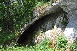
Betal Rock Shelter, a karst cave located on the south-eastern edge of the Lower Pivka river valley on a slope just above the road from Postojna to Bukovje is a site where rich cultural sediment layers with remains of stone tools, artifacts, and numerous fossilized bones of contemporary animals were found. Its entrance was formed by the collapse of the 174 m (571 ft) long cave's ceiling, carved out by the waters of the Pivka River.

The small Sirgenstein Cave, German: Sirgensteinhöhle is situated 565 m (1,854 ft) above sea level inside the 20 m (66 ft) high Sirgenstein, a limestone rock. The cave sits 35 m (115 ft) above the Ach River valley bottom in the central Swabian Jura, southern Germany. Archaeologist R. R. Schmidt excavated the site in 1906 during which he identified indices of prehistoric human presence. He recorded the complete stratigraphic sequence of Palaeolithic and Neolithic origin. In his 1910 analysis Schmidt inspired future archaeologists with his pioneering concept of including the excavation site within its geographic region, contextualizing it within a wide scientific spectrum and demonstrated valuable results as he correlated the Sirgenstein layer structure to those of prehistoric sites in France.

Furninha, also known as Dominique's cave, is a natural cave on the southern slope of the Peniche peninsula in Portugal. The cave is situated on the cliffs between the Peniche Fortress and the Cape Carvoeiro. The cave is located furthest west of any Neanderthal site. Neanderthals became extinct over 40,000 years ago. The cave was also inhabited by modern humans during the Neolithic.

The Cave of Aroeira is an archaeological and paleoanthropological site in the central limestone massif of the Portuguese Estremadura. The cave is located in the village of Almonda, in the civil parish of Zibreira, in the municipality of Torres Novas in the district of Santarém. The cave contained stones from the Paleolithic Acheulean culture, and the skull of Homo heidelbergensis, circa 400,000 years old. The discovery of Aroeira 3 was announced in spring 2017 - the earliest human trace in Portugal.

Aroeira 3 is a 400,000 year old Homo heidelbergensis hominid skull which was discovered in the Aroeira cave, Portugal. It is the earliest human trace in Portugal. H. heidelbergensis existed at the transition between Homo erectus and early Neanderthals and used both stone tools and fire. The skull was damaged during the 2014 excavation but was restored in the following two years. In 2017 the description of the skull was published in PNAS. It is on display in the National Archaeology Museum (Lisbon).

The Artificial caves of Alapraia constitute a prehistoric necropolis formed by four subterranean tombs or hypogea that were created by excavating marlstone rock using stone tools. They are situated in the centre of the suburb of Alapraia in Estoril, Lisbon District, Portugal and are believed to date back to the last quarter of the 4th Millennium BCE and to have been used as a necropolis for over one thousand years.

The Cave of Pego do Diabo is a small karst cave in a Turonian limestone outcrop located about 250 metres above sea level in the municipality of Loures, about 20 km north of Lisbon in Portugal. The erosion of the outcrop resulted in a set of openings in the rocks wide enough to be exploited by humans. Several archaeological studies have been conducted within the cave, which give insights into the duration of Neanderthal presence on the Iberian Peninsula and to the presence of carnivorous animals during the Paleolithic.
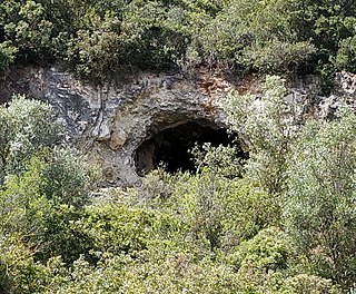
The Cave of Pedra Furada is a small cave located in the municipality of Vila Franca de Xira, about 20km north of Lisbon in Portugal. Archaeological studies conducted within the cave suggest it was occupied intermittently by humans during at least three periods between the end of the fourth millennium BC and the second millennium BC. The cave results from karstification of the limestone Upper Jurassic Massif.

The Anta do Alto da Toupeira, also called the Anta da Toupeira or the Anta de Salemas, is a Neolithic dolmen, or megalithic tomb, situated in the parish of Lousa in the municipality of Loures, in the Lisbon District of Portugal. It dates back to the Chalcolithic.

The four Artificial caves of Casal do Pardo, also known as the Caves of Quinta do Anjo, were neolithic tombs. They are situated in Palmela municipality in the Setúbal District, of Portugal, about 25 km (16 mi) south of the capital of Lisbon. These caves were classified as a National Monument of Portugal in 1934.

The Necropolis of Carenque is an archaeological site consisting of three well-preserved late Neolithic collective sepulchres or tombs, dating back to about 3000 BCE, which are dug into smooth limestone outcrops. It is situated in the municipality of Amadora in the Lisbon District of Portugal.
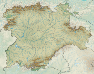
The archaeological site of Atapuerca is located on the Atapuerca Mountains in the north of Spain. The archaeological significance of the area became increasingly apparent during the construction of a railway line as deep trenches were cut through the rocks and sediments of the Gran Dolina site, the Galería Elefante and at Sima de los Huesos. The subsequent excavation of 1964 under the direction of Francisco Jordá Cerdá succeeded with the discovery of anthropogenic artifacts and human fossils from a broad time range of early humans, hunter-gatherer groups to Bronze Age occupants and modern human settlers. Further campaigns expanded and interdisciplinary work has been undertaken by several teams, led by Emiliano Aguirre from 1978 to 1990 and later jointly by Eudald Carbonell, José María Bermúdez de Castro and Juan Luis Arsuaga.
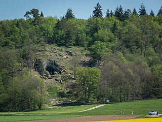
The Bockstein Cave, German: Bocksteinhöhle is part of the Bockstein complex – a White Jurassic limestone rock massif. The 15 by 20 m rock shelter, among small peripheral caves is situated around 12 m (39 ft) above the Lone River valley bottom, north of the towns of Rammingen and Öllingen, Heidenheim district in the central Swabian Jura, southern Germany. Several small openings, that are the actual entrances to the site, lead to various cave sections. The large frontal opening is of modern origin, created during the first excavation works in the late 19th century.


