Plettenberg Bay, nicknamed Plett, is the primary town of the Bitou Local Municipality in the Western Cape Province of South Africa. According to the census of 2001, the town had a population of 29,149. It was originally named Bahia Formosa by early Portuguese explorers and lies on South Africa's Garden Route 210 km from Port Elizabeth and about 600 km from Cape Town.

Wilton is a term archaeologists use to generalize archaeological sites and cultures that share similar stone and non-stone technology dating from 8,000-4,000 years ago. Archaeologists often refer to Wilton as a technocomplex, or Industry. Technological industries are defined by a common tradition of stone tool assemblages, but these technological industries extend to common cultural behaviors. As such, archaeologists use these industries to define a discrete cultural taxonomy. However, technological industries have the potential to generalize different cultures and communities at regional scales that, in more local settings, are distinguishable in both technology and cultural behaviors.
Blombos Cave is an archaeological site located in Blombos Private Nature Reserve, about 300 km east of Cape Town on the Southern Cape coastline, South Africa. The cave contains Middle Stone Age (MSA) deposits currently dated at between c. 100,000 and 70,000 years Before Present (BP), and a Late Stone Age sequence dated at between 2000 and 300 years BP. The cave site was first excavated in 1991 and field work has been conducted there on a regular basis since 1997, and is ongoing.
Hilary John Deacon was a South African archaeologist and academic. He was professor of archaeology at the University of Stellenbosch in Stellenbosch, South Africa. His research focused on the emergence of modern humans and African archaeology. He was principal researcher at the Klasies River Caves, one of the oldest known sites of anatomically modern humans, who lived there circa 125,000 years ago.
Janette Deacon is a South African archaeologist specialising in heritage management and rock art conservation. She has studied the changes in stone tools from sites in the southern Cape in relation to climate change over the past 20,000 years. From 1985, she located rock engravings at places where the /Xam informants of Wilhelm Bleek and Lucy Lloyd lived in the nineteenth century. She served as a member of the SAHRA Council and was first chairperson of Heritage Western Cape.
Wonderwerk Cave is an archaeological site, formed originally as an ancient solution cavity in dolomite rocks of the Kuruman Hills, situated between Danielskuil and Kuruman in the Northern Cape Province, South Africa. It is a National Heritage Site, managed as a satellite of the McGregor Museum in Kimberley. Geologically, hillside erosion exposed the northern end of the cavity, which extends horizontally for about 140 m (460 ft) into the base of a hill. Accumulated deposits inside the cave, up to 7 m (23 ft) in-depth, reflect natural sedimentation processes such as water and wind deposition as well as the activities of animals, birds, and human ancestors over some 2 million years. The site has been studied and excavated by archaeologists since the 1940s and research here generates important insights into human history in the subcontinent of Southern Africa. Evidence within Wonderwerk cave has been called the oldest controlled fire. Wonderwerk means "miracle" in the Afrikaans language.
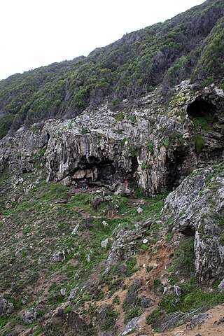
Howieson's Poort Shelter is a small rock shelter in South Africa containing the archaeological site from which the Howiesons Poort period in the Middle Stone Age gets its name. This period lasted around 5,000 years, between roughly 65,800 BP and 59,500 BP. This period is important as it, together with the Stillbay period 7,000 years earlier, provides the first evidence of human symbolism and technological skills that were later to appear in the Upper Paleolithic.

Border Cave is an archaeological site located in the western Lebombo Mountains in Kwazulu-Natal. The rock shelter has one of the longest archaeological records in southern Africa, which spans from the Middle Stone Age to the Iron Age.

Diepkloof Rock Shelter is a rock shelter in Western Cape, South Africa in which has been found some of the earliest evidence of the human use of symbols, in the form of patterns engraved upon ostrich eggshell water containers. These date around 60,000 years ago.

The Apollo 11 Cave is an archeological site in the ǀAi-ǀAis/Richtersveld Transfrontier Park of south-western Namibia, approximately 250 km (160 mi) southwest of Keetmanshoop. The name given to the surrounding area and presumably the cave by the Nama people was "Goachanas". However, the cave was given its name by German archaeologist Wolfgang Erich Wendt (1934-2015) in reference to Apollo 11's then recent return to Earth.
Mussel Point also known as Mike Taylor's Midden (MTM) is possibly the largest of 13 megamiddens found along the South African West Coast. MTM is the only open site with remains from the early pottery period in the Elands Bay and Lamberts Bay areas at 32°18′S18°19′E.
Byneskranskop is an archaeological site in present-day South Africa where the coastal plain meets the southern Cape Fold Belt. Neolithic human remains have been discovered in caves at the site. Carbon dating of the remains indicates the bodies date from 3,000 to 2,000 years BCE.

Kaditshwene aka Gaditshweni or Karechuenya, was a South African Iron Age settlement some 25 kilometres (16 mi) northeast of the town of Zeerust, North West province.
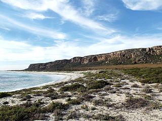
Elands Bay Cave is located near the mouth of the Verlorenvlei estuary on the Atlantic coast of South Africa's Western Cape Province. The climate has continuously become drier since the habitation of hunter-gatherers in the Later Pleistocene. The archaeological remains recovered from previous excavations at Elands Bay Cave have been studied to help answer questions regarding the relationship of people and their landscape, the role of climate change that could have determined or influenced subsistence changes, and the impact of pastoralism and agriculture on hunter-gatherer communities.
Melkhoutboom Cave is an archaeological site dating to the Later Stone Age, located in the Zuurberg Mountains, Cape Folded Mountain Belt, in the Addo Elephant National Park, Sarah Baartman District Municipality in the Eastern Cape Province of South Africa.
Njoro River Cave is an archaeological site on the Mau Escarpment, Kenya, that was first excavated in 1938 by Mary Leakey and her husband Louis Leakey. Excavations revealed a mass cremation site created by Elmenteitan pastoralists during the Pastoral Neolithic roughly 3350-3050 BP. Excavations also uncovered pottery, beads, stone bowls, basket work, pestles and flakes. The Leakeys' excavation was one of the earliest to uncover ancient beads and tools in the area and a later investigation in 1950 was the first to use radiocarbon dating in East Africa.
Boomplaas Cave is located in the Cango Valley in the foothills of the Swartberg mountain range, north of Oudtshoorn, Eden District Municipality in the Western Cape Province, South Africa. It has a 5 m (16 ft) deep stratified archaeological sequence of human presence, occupation and hunter-gatherer/herder acculturation that might date back as far as 80,000 years. The site's documentation contributed to the reconstruction of palaeo-environments in the context of changes in climate within periods of the Late Pleistocene and the Holocene. The cave has served multiple functions during its occupation, such as a kraal (enclosure) for animals, a place for the storage of oil rich fruits and as a hunting camp. Circular stone hearths and calcified dung remains of domesticated sheep as well as stone adzes and pottery art were excavated indicating that humans lived at the site and kept animals.
Matupi Cave is a cave in the Mount Hoyo massif of the Ituri Rainforest, Democratic Republic of the Congo, where archaeologists have found evidence for Late Stone Age human occupation spanning over 40,000 years. The cave has some of the earliest evidence in the world for microlithic tool technologies.
Rose Cottage Cave (RCC) is an archaeological site in the Free State, South Africa, situated only a few kilometers away from Ladybrand, close to the Caledon River, on the northern slopes of the Platberg. RCC is an important site because of its long cultural sequence, its roots in modern human behavior, and the movement of early modern humans out of Africa. Rose Cottage is the only site from the Middle Stone Age that can tell us about the behavioral variability of hunter-gatherers during the Late Pleistocene and Holocene. Berry D. Malan excavated the site between 1943 and 1946, shortly followed by Peter B. Beaumont in the early 1960s, and the most recent excavations occurred from 1987 to 1997 by Lyn Wadley and Philip Harper in 1989 under Wadley's supervision. Humans have inhabited Rose Cottage for over 100,000 years throughout the Middle and Later Stone Ages. Site formation and sediment formation processes at Rose Cottage appear to be primarily anthropogenic. Archaeological research focuses primarily on blade technology and tool forms from the Middle Stone Age and the implications of modern human behavior. Structurally, the cave measures more than 6 meters deep and about 20 by 10 meters. A boulder encloses the front, protecting the cave, but allowing a small opening for a skylight and narrow entrances on both the east and west sides.
Antidorcas australis, also known as the southern springbok, is an extinct species of antelope from the Pleistocene and Holocene of South Africa. It is a close relative of the living springbok.