Barton Creek Cave

Last updated
Barton Creek Cave
BartonCreekBZE.jpg
Barton Creek Cave
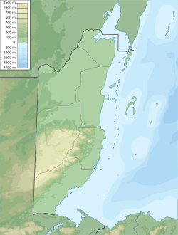
Belize physical map.svg
Archaeological site icon (red).svg
location in Belize
Location Barton Creek, near San Ignacio, Cayo District
Region Belize
Coordinates 17°6′46″N88°55′41″W / 17.11278°N 88.92806°W / 17.11278; -88.92806 Coordinates: 17°6′46″N88°55′41″W / 17.11278°N 88.92806°W / 17.11278; -88.92806
Cave interior Barton Creek Cave 2.png
Cave interior

Barton Creek Cave is a natural cave in Belize, known as both an archaeological site and as a tourist destination. It is located in the upper Barton Creek area near San Ignacio in the Cayo District.

Contents

Description

Barton Creek Cave is a primarily single-passage resurging stream cave. By 2002 a cave survey had been completed by the Western Belize Regional Cave Project, recording a total of 6,400 m (21,000 ft) of passages; dye traces at sinking streams above the cave indicated that there could be a further 6 km (3.7 mi) of cave passages beyond the terminal sumps. By 2005 the Xibalba Mapping and Exploration Team had extended the survey to 8 km (5.0 mi).

Archaeology

Extensive looting of artifacts occurred soon after the cave was first reported, but it remains an important site for archaeologists. Evidence of cave use by the Maya exists on ten ledges within the first kilometer of cave passage. Pottery shards indicate use between the Early Classic (200 to 600 CE) to the Late Classic (600 to 900 CE) periods. The remains of at least 28 humans have been found within the cave.

Related Research Articles

Toledo District District of Belize

Toledo District is the southernmost district in Belize, and Punta Gorda is the District capital. It is the least developed region in the country, and it features some of the most pristine rainforests, extensive cave networks, coastal lowland plains, and offshore cays. Toledo is home to a wide range of cultures: Mopan and Kekchi Maya, Creole, the Garifuna, East Indians, Mennonites, Mestizos, and descendants of US Confederate settlers.

Nim Li Punit

Nim Li Punit is a Maya Classic Period site in the Toledo District of the nation of Belize, located 50 kilometres north of the town of Punta Gorda, and directly adjacent to the village of Indian Creek. Nim Li Punit is sometimes known as Big Hat or Top Hat; the name is Kekchi Maya for "Big Hat", referring to the large elaborate head-dress on a stela sculpture found on site depicting one of the site's ancient kings. It is bordered by the Maya Mountains to the west and lowland swamps and the Caribbean Sea to the east.

Lubaantun

Lubaantun is a pre-Columbian ruined city of the Maya civilization in southern Belize, Central America. Lubaantun is in Belize's Toledo District, about 42 kilometres (26 mi) northwest of Punta Gorda, and approximately 3.2 kilometres (2 mi) from the village of San Pedro Columbia, at an elevation of 61 metres (200 ft) feet above mean sea level. One of the most distinguishing features of Lubaantun is the large collection of miniature ceramic objects found on site; these detailed constructs are thought to have been charmstones or ritual-accompanying accoutrements.

Maya ruins of Belize Historically important pre-Columbian Maya archaeological sites

The Maya ruins of Belize include a number of well-known and historically important pre-Columbian Maya archaeological sites. Belize is considered part of the southern Maya lowlands of the Mesoamerican culture area, and the sites found there were occupied from the Preclassic until and after the arrival of the Spanish in the 16th century.

Cahal Pech

Cahal Pech is a Maya site located near the town of San Ignacio in the Cayo District of Belize. The site was a palatial, hilltop home for an elite Maya family, and though the most major construction dates to the Classic period, evidence of continuous habitation has been dated to as far back as 1200 BCE during the Early Middle Formative period, making Cahal Pech one of the oldest recognizably Maya sites in Western Belize.

Actun Tunichil Muknal Cave in Belize

Actun Tunichil Muknal, also known locally as ATM, is a cave in Belize, near San Ignacio, Cayo District, notable as a Maya archaeological site that includes skeletons, ceramics, and stoneware. There are several areas with skeletal remains in the main chamber. The best known is "The Crystal Maiden", the skeleton of an adolescent, possibly a sacrifice victim, whose bones have been calcified to a sparkling, crystallized appearance.

El Pilar Mayan archaeological site in Belize and Guatemala

El Pilar is an ancient Maya city center located on the Belize-Guatemala border. The site is located 12 kilometres (7.5 mi) north of San Ignacio, Belize and can be accessed through the San Ignacio and Bullet Tree Falls on the Belize River. The name "El Pilar" is Spanish for "watering basin", reflecting the abundance of streams around the site and below its escarpment, which is rare in the Maya area.

Mountain Pine Ridge Forest Reserve Nature reserve in Belize

Mountain Pine Ridge Forest Reserve is a nature reserve in the Cayo District of southern central Belize. It was established in 1944 to protect and manage the native Belizean pine forests. Its boundaries are poorly defined, but it is estimated to cover an area of 106,352.5 acres (430 km2), although much of the reserve has been leased.

Cheyenne Bottoms Body of water

Cheyenne Bottoms is a wetland in the central Great Plains of North America. Occupying approximately 41,000 acres in central Kansas, it is the largest wetland in the interior United States. The Bottoms is a critical stopping point on the Central Flyway for millions of birds which migrate through the region annually.

KaʼKabish Archaeological site

KaʼKabish is an archaeological site in the Orange Walk District of Belize, Central America, located near the Maya sites of Lamanai, El Pozito, and Blue Creek. It was once a moderate sized city, built as part of the Maya civilization, and has been determined to have been largely autonomous throughout its history. The modern communities of Indian Church and San Filipe are in close proximity to KaʼKabish, and the Mennonite community of Blue Creek is slightly further afield. A road connecting Indian Church to San Filipe separates the site into two areas, the North Complex and the South Complex.

Bladen Nature Reserve Nature reserve in Toledo, Belize

Bladen Nature Reserve is a landscape of caves, sinkholes, pristine streams and rivers, undisturbed old growth rainforest and an abundance of highly diverse flora and fauna which includes a great deal of rare and endemic species.

Pusilhá is an archaeological site in Belize. The location of this Late Classic Maya urban complex, along the east and west flow of trade, made the city a major transfer point for economic activities in the whole region. In addition, the city gave archaeologists a historical view of a secondary Maya site. Large and extended excavation efforts have changed the overall picture of Maya social and political relationships between larger and smaller cities and challenged the prevailing view of conquest and absorption of smaller cities into the larger cities in the region. The research conducted at Pusilhá began in 1927 and continues to this day.

La Milpa Mayan archaeological site in Belize

La Milpa is an archaeological site and an ancient Maya city within the Three River region of Northwest Belize bordering Mexico and Guatemala. La Milpa is located between the sites of Rio Azul and Lamanai. Currently, La Milpa lies within the nature preserve owned by the Programme for Belize, a non-profit organization. PfB acquired land for the preserve from the Coco-Cola Company, who purchased land in Belize in 1988 with the goals of tearing down the rainforest to create a citrus plantation, however donated the land to conservation and management project in 1990 and 1992. Following Caracol and Lamanai, La Milpa is the third largest site in Belize with the Main Plaza alone covering 18,000 square meters, making it one of the largest in the entire Maya region.

Colha, Belize Mayan archaeological site in Belize

Colha, Belize is a Maya archaeological site located in northern portion of the country, about 52 km. north of Belize City, near the town of Orange Walk. The site is one of the earliest in the Maya region and remains important to the archaeological record of the Maya culture well into the Postclassic Period. According to Palma Buttles, “Archaeological evidence from Colha allows for the interpretation occupation from the Early Preceramic (3400-1900B.C.) to Middle Postclassic with population peaks occurring in the Late Preclassic and again in the Late Classic ”. These peaks in population are directly related to the presence of stone tool workshops at the site. Colha's proximity to an important source of high quality chert that is found in the Cenozoic limestone of the region and well traveled trade routes was utilized by the inhabitants to develop a niche in the Maya trade market that may have extended to the Greater Antilles. During the Late Preclassic and Late Classic periods, Colha served as a primary supplier of worked stone tools for the region. It has been estimated that the 36 workshops at Colha produced nearly 4 million chert and obsidian tools and eccentrics that were dispersed throughout Mesoamerica during the Maya era. This made it an important player in the trade of essential good throughout the area.

Baking Pot

Baking Pot is a Maya archaeological site located in the Belize River Valley on the southern bank of the river, northeast of modern-day town of San Ignacio in the Cayo District of Belize; it is 6 kilometres (3.7 mi) downstream from the Barton Ramie and Lower Dover archaeological sites. Baking Pot is associated with an extensive amount of research into Maya settlements, community-based archaeology, and of agricultural production; the site possesses lithic workshops, and possible evidence of cash-cropping cacao as well as a long occupation from the Preclassic through to the Postclassic period.

Pacbitun is a Maya archaeological site located near the town of San Ignacio, Belize, in the Cayo District of west central Belize. The modern Maya name given to the site means “stone set in earth”, likely a reference to multiple fragments of stone monuments. The site, at about 240 m above sea level, is one of the earliest known from the southern Maya Lowlands, and was inhabited for almost 2000 years, from ca. 900 BCE to 900 CE. Strategically, it straddles a territory of rolling, hilly terrain between the Mountain Pine Ridge and the tropical forest covered lowlands of the Upper Belize River Valley.

Caracol Maya archaeological site in Belize

Caracol is a large ancient Maya archaeological site, located in what is now the Cayo District, of Belize. It is situated approximately 40 kilometres (25 mi) south of Xunantunich, and the town of San Ignacio, and 15 km (9.3 mi) from the Macal River. It rests on the Vaca Plateau, at an elevation of 500 m (1,600 ft) above sea-level, in the foothills of the Maya Mountains. Long thought to be a tertiary center, it is now known that the site was one of the most important regional political centers of the Maya Lowlands during the Classic Period. Caracol covered approximately 200 square kilometres (77 sq mi), covering an area much larger than present-day Belize City, the largest metropolitan area in the country, and supported more than twice the modern city's population.

Lower Dover Maya archaeological site in the Belize River Valley

Lower Dover is a Maya archaeological site in the Belize River Valley. It is located on the grounds of the Lower Dover Field Station & Jungle Lodge, in Unitedville, Cayo District, Belize. The site is bordered by the Belize River to the north, Upper Barton Creek to the west, Lower Barton Creek to the east, and the Western Highway to the south. Lower Dover is one of several Maya archaeological sites in the area; it is across the Belize River from Barton Ramie, 3 kilometers west of Blackman Eddy, and 6 kilometers east of Baking Pot.

Jaime José Awe is a Belizean archaeologist who specializes in the ancient Maya, an Associate Professor of Anthropology at Northern Arizona University, and the Director of the Belize Valley Archaeological Reconnaissance Project.

Pınargözü Cave, is a cave 18 kilometres (11 mi) west of the town of Yenişarbademli in Isparta Province, Turkey. It is considered the longest cave in Turkey, although it has not yet been fully explored, and the precise extent to which it has been explored is in dispute.

References