Related Research Articles

Hattieville is a village in the Belize District of the nation of Belize. It is located at 17N 88W, at an elevation of 196 feet above mean sea level, and has a population of about 1,300 people. Hattieville was established as a refugee camp after Hurricane Hattie made many people homeless in Belize City when it hit in 1961, but it became a permanent town.
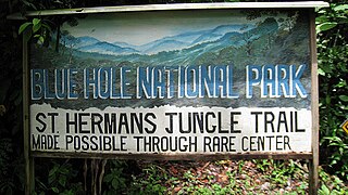
St. Herman's Blue Hole National Park is a national park located just off the Hummingbird Highway in Cayo District of Belize, near Belmopan, the capital city. It is over 500 acres (2 km²) in area, and contains two cave systems, various natural trails, and the cool jungle pool from which the park gets its name. The park is managed by the Belize Audubon Society.

The National Assembly is the bicameral legislature of the nation of Belize. It is divided into the House of Representatives, with 31 members, elected by universal suffrage, and the Senate, with 13 members, appointed by the Governor-General in consultation with the Prime Minister and the Leader of the Opposition. The presiding officer of the House is the Speaker, while the Senate is presided over by the President.

Banco Chinchorro is an atoll reef lying off the southeast coast of the Municipality of Othón P. Blanco in Quintana Roo, Mexico, near Belize. It was featured throughout the 2009 semi-documentary film Alamar by Pedro González-Rubio.

Indian Church is a small remote village in the Orange Walk District of Belize. It is located on the west bank of New River, neighbouring the town of San Carlos to its south, and the Maya ruins of Lamanai to its north. According to the 2010 census, Indian Church has a population of 267 people in 66 households. The village is named for the historic Spanish churches recovered among the ancient Maya ruins. The residents lived among the ruins until 1991 when the Government of Belize established the 2-square-mile (5.2 km2) Lamanai Archaeological Reserve maintained by Belize's Institute of Archaeology.

Albert is an electoral constituency in the Belize District of Belize.
The Marylebone Cricket Club Grounds is a Belizean football stadium, located on the Northside of Belize City, Belize.
Wesley College is a public coeducational high school located in Yarborough area of Belize City, Belize.
Gardenia is a village in Belize District, Belize located about 20 miles (32 km) north of Belize City.

Akhzivland is a micronation between Nahariya and the Lebanese border on the Israeli west coast, founded by Eli Avivi in 1971. The micronation is promoted by the Israel Ministry of Tourism.

The Cathedral Church of St. John the Baptist is the primary cathedral of the Anglican Diocese of Belize.
The Belmopan Public Library located on Mot Mot Ln, Belmopan, the capital city of Belize, was inaugurated on August 24, 1970. The process of constructing a local library began after Hurricane Hattie, in 1961, devastated the previous capital, Belize City, located on the east coast of Belize. In the wake of this destruction the government of Belize agreed to relocate the capital further inland and it was during this time in 1961 that Belmopan was constructed from nothing but a thinly populated area of preserved bush otherwise known as jungle. During the construction of the new capital the local residents identified a need for a public library and the British Overseas Development Mission approved the funding of the Belmopan Public Library. The Honorable Santiago Perdomo, Ministry of Education, and Leo Bradley, Chief Librarian finally inaugurated the building in 1971 and the same building has been the location of the Belmopan Public Library for the last 41 years.
San Ignacio Resort Hotel is a hotel resort on Buena Vista Street, San Ignacio, Cayo District, Belize. It is located just off of the Western Highway, above the Macal River valley. It contains the Running W Steak House, The Stork Club and bar, and the Princess Casino. The hotel is popular with archaeologists working in the vicinity.
Rockstone Pond is a settlement located in Belize. It is a mainland village located in Belize District, near the Mayan site of Altun Ha.
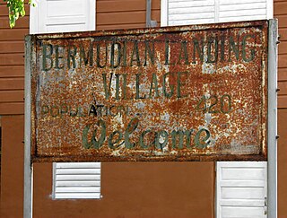
Bermudian Landing is a village in the nation of Belize, located near Scotland Halfmoon in Belize District. The name comes from the Bermuda grass planted by the early loggers to feed their oxen, who were used to drag the mahogany to the landing.
La Democracia is a populated settlement located in the nation of Belize. It is a mainland village that is located in Belize District.
Serpon Sugar Mill is an historical site in Belize, consisting of the remnants of a steam-powered sugar mill whose construction in 1865 marked the beginning of the country's industrial era. It is located near the village of Sittee River in the Stann Creek district.

Lighthouse Reef is an atoll in the Caribbean Sea, the easternmost part of the Belize Barrier Reef and one of its three atolls, the other two being Turneffe Atoll and Glover's Reef. Lighthouse Reef is located about 80 kilometres (50 mi) southeast of Belize City. The atoll is of oblong shape, approximately 35 kilometres (22 mi) long from north to south, and about 8 kilometres (5.0 mi) wide. It forms a shallow sandy lagoon with an area of 120 square kilometres (46 sq mi) and a depth between 2 to 6 metres deep.

Che Chem Ha Cave or Chechem Ha Cave is a Mayan Ceremonial Cave, known to be a major tourist destination. It is located 8 miles (13 km) southeast of Benque at the start of the Maya Mountains of Belize.
Satala is one of Pago Pago’s constituent villages and is located in Pago Pago Bay on Tutuila Island. Satala is in Maoputasi County in the Eastern District of the island. It is home to the historic Satala Cemetery, which is listed on the U.S. National Register of Historic Places, and the government-owned Ronald Reagan Marina Railway Shipyard.
References
- ↑ Belize Tourism Board. "Yarborough Cemetery". Travel Belize. Retrieved 13 August 2011.
- ↑ Vorhees, Mara; Brown, Joshua Samuel (2008). Lonely Planet: Belize (3 ed.). Lonely Planet. p. 95. ISBN 978-1-74104-703-5.