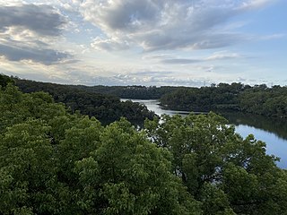
Georges River National Park is a protected Australian National Park, under the management of the NSW National Parks and Wildlife Service. The park falls in the regions of the Sutherland Shire Council and Canterbury-Bankstown Council. Located in the city of Sydney, 25 km south-west of the CBD, surrounded by neighbouring suburbs of Lugano, Illawong, Alfords Point, Padstow Heights, Revesby Heights, Picnic Point and Sandy Point. The primary use of the park is to service for recreational activities such as; bush walking, picnics, barbeques, boating, fishing, and water/jet skiing. The park is Segmented into 15 sectors along the riverbanks of the Georges River, encompassing 514 hectares (1,270-acres), housing many native aquatic and terrestrial Australian flora and fauna. The traditional custodians are the Dharug people located on the north side of the river, and Dharawal people located on the south of the river.

Belize City is the largest city in Belize and was once the capital of the former British Honduras. According to the 2010 census, Belize City has a population of 57,169 people in 16,162 households. It is at the mouth of the Haulover Creek, which is a distributary of the Belize River. The Belize River empties into the Caribbean Sea eight kilometres from Belize City on the Philip Goldson Highway on the coast of the Caribbean. The city is the country's principal port and its financial and industrial hub. Cruise ships drop anchor outside the port and are tendered by local citizens. The city was almost entirely destroyed in October 1961 when Hurricane Hattie swept ashore. It was the capital of British Honduras until the government was moved to the new capital of Belmopan in 1970.

Biscayne Bay is a lagoon, with characteristics of an estuary, located on the Atlantic coast of South Florida, United States. The northern end of the lagoon is surrounded by the densely developed heart of the Miami metropolitan area, while the southern end is largely undeveloped, with a large portion of the lagoon included in Biscayne National Park. Sources differ on the extent of the lagoon. The part of the lagoon that is traditionally called "Biscayne Bay" is approximately 35 miles (56 km) long and up to 8 miles (13 km) wide, with a surface area of 573 square kilometres (221 sq mi). Various definitions may include Dumfoundling Bay, Card Sound, and Barnes Sound in a larger "Biscayne Bay", which is 60 miles (97 km) long, with a surface area of about 703 square kilometres (271 sq mi).

Lake Alexandrina is a coastal freshwater lake located between the Fleurieu and Kangaroo Island and Murray and Mallee regions of South Australia, about 100 kilometres (62 mi) south-east of Adelaide. The lake adjoins the smaller Lake Albert and a coastal lagoon called The Coorong to its southeast, before draining into the Great Australian Bight via a short, narrow opening known as Murray Mouth.

The Indian River Lagoon is a grouping of three lagoons: the Mosquito Lagoon, the Banana River, and the Indian River, on the Atlantic Coast of Florida; one of the most biodiverse estuaries in the Northern Hemisphere and is home to more than 4,300 species of plants and animals.

The Indian River is a 121-mile (195 km) long brackish lagoon in Florida. It is part of the Indian River Lagoon system, which in turn forms part of the Atlantic Intracoastal Waterway. It was originally named Rio de Ais after the Ais Indian tribe, who lived along the east coast of Florida, but was later given its current name.

There is no active rail transport in Belize, although there were lines in the past.

The Haulover Canal is a waterway north of Merritt Island, Florida, near the former site of Allenhurst, that connects Mosquito Lagoon with the Indian River, and is part of the Intracoastal Waterway.

The Batiquitos Lagoon is a coastal wetland and estuary located between southern Carlsbad and Encinitas, in the North County region of San Diego County, California. The lagoon itself consists of 610 acres with a drainage basin of about 55,000 acres. Its primary freshwater tributaries being San Marcos Creek from the east and Encinitas Creek which flows north along Green Valley, entering the lagoon under El Camino Real and La Costa Avenue, respectively. It is one of the few remaining tidal wetlands on the southern California coast.
The Rio Bravo Conservation and Management Area is a nature reserve located in northwestern Belize. Rio Bravo, as it is known, was established by Programme for Belize in 1988 with the purchase of 110,044 acres of land from Gallon Jug Agroindustries. With logging encroachment imminent in 1989, the Nature Conservancy joined Programme for Belize to protect the land. Additional land donations from Coca-Cola Foods, Inc. and purchases from New River Enterprises Ltd. enlarged the protected area to 230,875 acres (934.32 km2). Rio Bravo is the largest terrestrial conservation area in Belize, comprising 4% of the country's total land area.

Cheyenne Bottoms is a wetland in the central Great Plains of North America. Occupying approximately 41,000 acres in central Kansas, it is the largest wetland in the interior United States. The Bottoms is a critical stopping point on the Central Flyway for millions of birds which migrate through the region annually.
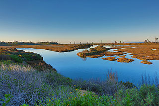
San Elijo Lagoon Ecological Reserve is one of the largest remaining coastal wetlands in San Diego County, California, United States.

Crooked Tree Wild Life Sanctuary (CTWS) is a protected area in Belize. It is recognized as a Wetland of International Importance. It was designated as a waterfowl habitat on April 22, 1998 under the Ramsar Convention on Wetlands. During Belize's dry season many resident and migratory birds find refuge in the lagoons. The sanctuary contains 16,400 acres of lagoons, creeks, log wood swamps, broad leaf forest and pine savanna, home to hundreds of species of wildlife. The Sanctuary protects globally endangered species including the Central American River Turtle, Mexican Black Howler Monkey, and Yellow-headed Parrot.

Bladen Nature Reserve is a landscape of caves, sinkholes, pristine streams and rivers, undisturbed old growth rainforest and an abundance of highly diverse flora and fauna which includes a great deal of rare and endemic species.

Tortuguero National Park is a national park in the Limón Province of Costa Rica. It is situated within the Tortuguero Conservation Area of the northeastern part of the country. Despite its remote location, reachable only by airplane or boat, it is the third-most visited park in Costa Rica. The park has a large variety of biological diversity due to the existence within the reserve of eleven different habitats, including rainforest, mangrove forests, swamps, beaches, and lagoons. Located in a tropical climate, it is very humid, and receives up to 250 inches (6,400 mm) of rain a year.

Muthupet Lagoon is located at the southern end of the Cauvery river delta on the Bay of Bengal, covering an area of approximately 6,803.01 ha of which only 4% is occupied by well-grown mangroves. The rivers Paminiyar, Koraiyar, Kilaithankiyar, Marakkakoraiyar and other tributaries of the river Cauvery flow through Muthupet and adjacent villages. At the tail end, they form a lagoon before meeting the sea. The northern and western borders of the lagoon are occupied by muddy silt ground which is devoid of mangroves. The mangroves beyond Muthupet lagoon are discontinuously found along the shore and extended up to Point Calimere. Muthupet mangrove forest was under the control of Chatram Department from 1853 to 1912. The Government of the Presidency of Madras Gazette (1937) shows, from 1923 to 1936, half of the revenue obtained from selling mangrove products was paid to the revenue department and the remaining half was spent to maintain the "Chatrams". The Government declared the Muthupet mangrove forest as revenue forest in February 1937 and accordingly the mangrove forest was handed over to the forest department of the Madras Presidency.

Moulting Lagoon Important Bird Area is a composite wetland site in eastern Tasmania, Australia. It comprises two adjacent and hydrologically continuous wetlands – Moulting Lagoon and the Apsley Marshes – at the head of Great Oyster Bay, near the base of the Freycinet Peninsula, between the towns of Swansea and Bicheno. Both components of the site are listed separately under the Ramsar Convention as wetlands of international significance. Moulting Lagoon is so named because it is a traditional moulting place for black swans. It is an important site for waterbirds.
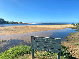
Wamberal Lagoon, an intermittently closed intermediate saline coastal lagoon, is located on the Central Coast region of New South Wales, Australia. Wamberal Lagoon is located between the beachside settlements of Forresters Beach and Wamberal, and adjacent to the east coast, about 87 kilometres (54 mi) north of Sydney.

The Little Llangothlin Nature Reserve is a protected wetland nature reserve that is located on the Northern Tablelands in the New England region of New South Wales, in eastern Australia. The 257-hectare (640-acre) reserve is situated approximately 10 kilometres (6.2 mi) north-east of the rural locality of Llangothlin, and some 20 kilometres (12 mi) north-east of Guyra.
The Aguacaliente Wildlife Sanctuary is a nature reserve in the Toledo District of southern Belize. It encompasses approximately 5,492 acres (22.23 km2) and was declared a sanctuary in 1998. The Sanctuary is critical for the preservation of biodiversity in Belize and the region. The National Park protects the central wetlands areas which consist of three fresh water lagoons and a hot-spring connected by a number of creeks hence the name Aguacaliente. It is co-managed by the Aguacaliente Management Team (AMT), a consortium of people from adjacent villages.
