Romito Cave

Last updated
Romito Cave
Grotta del Romito
Romito grotte un.JPG
Romito Cave
Relief map of Italy Calabria.png
Archaeological site icon (red).svg
location in Italy
Italy relief location map.jpg
Archaeological site icon (red).svg
Romito Cave (Italy)
Locationnear Papasidero,
Region Province of Cosenza, Calabria, Italy
Coordinates 39°54′40″N15°55′45″E / 39.91111°N 15.92917°E / 39.91111; 15.92917
Type limestone karst
Part of Pollino National Park
Length54 m (177 ft)
Height4 m
History
MaterialJurassic limestone
Periodslate Upper Paleolithic, Neolithic, since 17,000 years BP
Associated withPaleo-humans
Site notes
Excavation dates1962, 1971
ArchaeologistsPaolo Graziosi
Public accessyes

The Romito cave (Italian : Grotta del Romito) is a natural limestone cave in the Lao Valley of Pollino National Park, near the town of Papasidero in Calabria, Italy. Stratigraphic record of the first excavation confirmed prolonged paleo-human occupation during the Upper Paleolithic from 17,000 years ago and the Neolithic from 6,400 years ago. A single, but exquisite piece of Upper Paleolithic parietal rock engraving was documented. Several burial sites of varying age were initially discovered. Irregularly recurring sessions have led to additional finds, which suggests future excavation work. [1] Notable is the amount of accumulated data that has revealed deeper understanding of prehistoric daily life, the remarkable quality of the rock carvings and the burial named Romito 2, who exhibits features of pathological skeletal conditions (dwarfism).

Contents

Site

The Grotta del Romito was discovered by Agostino Miglio, then director of the Town Museum in Castrovillari in spring of 1961, who had received curious information from several local people. [lower-alpha 1] Excavations started in the summer of 1962 under the direction of Paolo Graziosi of the University of Florence. The Archaeological Park contains a small museum that presents the documentation and ongoing research. [1]

The site consists of two distinct areas: an outer former rock shelter or overhang with a length of 34 m (112 ft) and the inner cave, embedded into the limestone formation with a length of 20 m (66 ft) and accessible via a narrow tunnel. The interior is graced with a number of curiously shaped speleothems and prehistoric graffiti.

Stratigraphy

Aurochs engraving Romito aurochs.JPG
Aurochs engraving

Excavations in an enlarged trench performed in 2000, 2002, 2003 and 2007 exposed a long sequence of strata that forms seven main archaeological units (A–N) with episodes of intensive human occupation. The succession ranges from the Middle and Late Gravettian (units L-I-H-G) to the Early Epigravettian (unit F), Middle Epigravettian (lower unit E) and Late Epigravettian (upper unit E and units D-C-B). These cultural stages occurred between 26,000 and 10,000 years ago. [2]

Deposits near the entrance are about 8 m (26 ft) thick and consist of clastic sediments. Palaeolithic deposits, up to 6 m (20 ft) thick, underlie the middle Holocene layers, around 2 m (6.6 ft) thick and contain Middle and Late Neolithic pottery. Locally derived rock blocks up to 4 m (13 ft) in size rest on the talus slope in front of, and below, the entrance, indicating that there was originally an overhang that later collapsed. Deposits of human occupation contain numerous bones and stone tools, rounded out of size-exogenous pebbles and abundant charcoal detritus which is related to fireplaces. [2] About fifty discovered pottery shards are evidence for occupation of the cave during the Neolithic/Iron Age transition. [3]

Rock engravings

Aurochs Aurochs reconstruction.jpg
Aurochs

The bull, an Aurochs (Bos primigenius) is about 1.2 m (4 ft) long located at the mouth of the cave to the west and is engraved on three different levels of profiles. The stylistic scope is characteristic of the Mediterranean and the design of perfect proportions. The feeling of force transmitted from the overall design of the figure and the careful handling of the anatomical details amounts to the highest expression of Paleolithic realism in the region. In front of the rock another bovine figure has been cut, much more subtly, showing only the chest, head and part of the back. [4] On the opposite end of the shelter sits another engraved boulder, covered with numerous linear signs. Both engraving are dated to between 14,000 and 12,000 BP. [5]

Obsidian tools

The presence of large quantities of obsidian in a Neolithic layer suggests that the site was an intermediate base for the obsidian trade - that originated in the Aeolian Islands in the Tyrrhenian Sea to be transferred to the Adriatic Sea. [6] [7]

Burials

During the first excavations three graves were found, 9,200 years old and each containing a couple of human beings, placed in epipaleolithic layers. One grave was found inside the cave, the other two underneath the adjacent rock shelter near the bull-engraved stone. The specimens were named Romito 1 - 6 and all were between 15 and 25 years old and not taller than 1.5 m (5 ft). [8]

P. Graziosi discovered the diminutive remains of Romito 2 that turned out to be the earliest known case of dwarfism in the human skeletal record. The specimen, known as Romito 2, exhibits features typical of acromesomelic dysplasia. Romito 2 was characterized by unusually short forearms and lower legs, resulting in a rather short stature. Abnormal cartilage and bone development also affected other bones of the body, particularly those of the hands and feet. There was likely a limited extension of the elbows and arms and progressively abnormal curvature of the spine.

Besides providing evidence for a greater antiquity of dwarfism than previously known, the fact that this individual reached late adolescence attests to tolerance of Upper Paleolithic groups for severely abnormal individuals and their ability to support members who were of limited economic value to the social group. [9]

To date, nine intact, well preserved burials have been recovered from stratigraphic layers dating from ca. 18,000 to 11,000 BP, the majority of burials corresponding to a period of climatic amelioration from ca. 15,000 to 13,000 cal BP (Final Epigravettian). [10]

Footnotes

  1. sighted by two locals, Gianni Grisolia and Rocco Oliva. In 1954 amateur archaeologists Laino Bruzio, Luigi Attademo, had already mentioned the existence of a shelter with defined bull engravings

Related Research Articles

<span class="mw-page-title-main">South Asian Stone Age</span> Palaeolithic, Mesolithic and Neolithic periods in South Asia

The South Asian Stone Age covers the Palaeolithic, Mesolithic and Neolithic periods in the Indian subcontinent. Evidence for the most ancient Homo sapiens in South Asia has been found in the cave sites of Cudappah of India, Batadombalena and Belilena in Sri Lanka. In Mehrgarh, in what is today western Pakistan, the Neolithic began c. 7000 BCE and lasted until 3300 BCE and the first beginnings of the Bronze Age. In South India, the Mesolithic lasted until 3000 BCE, and the Neolithic until 1400 BCE, followed by a Megalithic transitional period mostly skipping the Bronze Age. The Iron Age in India began roughly simultaneously in North and South India, around c. 1200 to 1000 BCE.

<span class="mw-page-title-main">Papasidero</span> Comune in Calabria, Italy

Papasidero is a village and comune in the province of Cosenza in the Calabria region, southern Italy. It is part of Pollino National Park.

<span class="mw-page-title-main">Aadloun</span> Town in South Governorate, Lebanon

Aadloun, Adloun or Adlun is a coastal town in South Lebanon, 17 kilometres (11 mi) south of Sidon famous for its cultivation of watermelons. It is also the site of a Phoenician necropolis and prehistoric caves where four archaeological sites have been discovered and dated to the Stone Age. The evidence of human occupation of Abri Zumoffen has been dated as far back as 71,000 BCE with occupation of Bezez Cave dating back even further into the earlier Middle Paleolithic.

<span class="mw-page-title-main">Ksar Akil</span> Upper Paleolithic site in Lebanon

Ksar Akil is an archeological site 10 km (6.2 mi) northeast of Beirut in Lebanon. It is located about 800 m (2,600 ft) west of Antelias spring on the north bank of the northern tributary of the Wadi Antelias. It is a large rock shelter below a steep limestone cliff.

<span class="mw-page-title-main">Kozarnika, Dimovo Municipality</span> Cave and archaeological site in Bulgaria

Kozarnika or Peshtera Kozarnika is a cave in northwestern Bulgaria that was used as a hunters’ shelter as early as the Lower Paleolithic. It marks an older route of early human migration from Africa to Europe via the Balkans, prior to the other currently suggested route - the one across Gibraltar. The cave probably keeps the earliest evidence of human symbolic behaviour and the earliest European Gravette flint assemblages came to light here.

<span class="mw-page-title-main">Vela Spila</span> Cave and archaeological site in Croatia

The Vela Spila cave is situated above the town of Vela Luka on the island of Korčula, in Croatia on Pinski Rat hill at an elevation of approximately 130 m (430 ft). The cave consists of an elliptically shaped cavern that measures 40 m (130 ft) in length, 17 m (56 ft) in height, and is approximately 40 m (130 ft) wide. There are, similar to the Brillenhöhle in Germany, two openings in the roof of the cave which were caused by collapse at an as yet undetermined time.

Antelias Cave was a large cave located 2.5 km (1.6 mi) east of Antelias, 10 km (6.2 mi) northeast of Beirut close to the wadi of Ksar Akil.

<span class="mw-page-title-main">Hadži-Prodan's Cave</span> Cave and archaeological site in Serbia

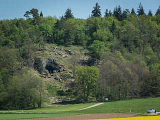
The Hadži-Prodan's Cave is an archaeological site of the Paleolithic period and a national natural monument, located in the village Raščići around 7 km (4.3 mi) from Ivanjica in western central Serbia. The rather narrow and high entrance with at an altitude of 630 m (2,070 ft) above sea level sits about 40 m (130 ft) above the Rašćanska river valley bed and is oriented towards the south. The 345 m (1,132 ft) long cave was formed during the Late Cretaceous in "thick-bedded to massive" Senonian limestone. Prehistoric pottery shards and Pleistocene faunal fossils had already been collected by Zoran Vučićević from Ivanjica. Animal fossils especially Cave bear and Iron Age artifact discoveries during an unrelated areal survey were reportedly made at the cave entrance and in the main cavern. The site is named in honor of Hadži-Prodan, a 19th century Serbian revolutionary.

<span class="mw-page-title-main">Ripari Villabruna</span> Cave and archaeological site in Italy

Ripari Villabruna is a small rock shelter in northern Italy with mesolithic burial remains. It contains several Cro-Magnon burials, with bodies and grave goods dated to 14,000 years BP. The site has added greatly to the understanding of the neolithic development of medical and religious practises in early human communities.

<span class="mw-page-title-main">Taforalt</span> Cave and archaeological site in Morocco

Taforalt, or Grotte des Pigeons, is a cave in the province of Berkane, Aït Iznasen region, Morocco, possibly the oldest cemetery in North Africa. It contained at least 34 Iberomaurusian adolescent and adult human skeletons, as well as younger ones, from the Upper Palaeolithic between 15,100 and 14,000 calendar years ago. There is archaeological evidence for Iberomaurusian occupation at the site between 23,200 and 12,600 calendar years ago, as well as evidence for Aterian occupation as old as 85,000 years.

<span class="mw-page-title-main">Grotta del Cavallo</span> Cave and archaeological site in Italy

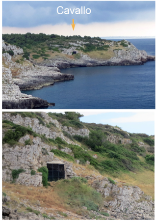
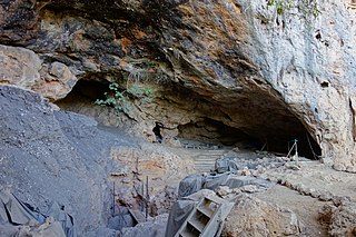
The Grotta del Cavallo or Cavallo Cave is a limestone cave in the region of Apulia, Southern Italy, near Nardò 90 km (55.92 mi) south of Taranto. The cave is about 15 m (49 ft) above present sea level. It has a rounded entrance, 5 m (16.40 ft) wide and 2.5 m (8.20 ft) high opening toward the sea. The cave was rediscovered in 1960 and two waves of excavations ensued. The first wave spanning from 1963 to 1966 and the second from 1986 to 2008. The cave was disturbed by looters during the period between the two waves of excavations, damaging the layers corresponding to the Upper Palaeolithic; because of this, the cave entrance is covered by a gate and is closed to the public.

<span class="mw-page-title-main">Theopetra Cave</span> Cave and archaeological site in Greece

Theopetra Cave is a limestone cave located in Theopetra village of Meteora municipality, Thessaly, Greece. It is situated on the northeast side of a limestone rock formation that is 3 km (2 mi) south of Kalambaka. The site has become increasingly important as human presence is attributed to all periods of the Middle and Upper Paleolithic, the Mesolithic, Neolithic and beyond, bridging the Pleistocene with the Holocene.

<span class="mw-page-title-main">Trou de l'Abîme</span> Caves and archaeological site in Belgium

Trou de l’Abîme also known as La caverne de l'Abîme and Couvin Cave is a karst cave located in Wallonia on the right bank of the Eau Noire river in the center of Couvin, Belgium, in Namur province. During various archaeological excavations of sediment deposits, Mousterian artefacts and a Neanderthal molar were discovered.

<span class="mw-page-title-main">Betal Rock Shelter</span> Cave and archaeological site in Slovenia

Betal Rock Shelter, a karst cave located on the south-eastern edge of the Lower Pivka river valley on a slope just above the road from Postojna to Bukovje is a site where rich cultural sediment layers with remains of stone tools, artifacts, and numerous fossilized bones of contemporary animals were found. Its entrance was formed by the collapse of the 174 m (571 ft) long cave's ceiling, carved out by the waters of the Pivka River.

<span class="mw-page-title-main">La Garma cave complex</span> Cave complex and archaeological site with prehistoric paintings in Spain

The La Garma cave complex is a parietal art-bearing paleoanthropological cave system in Cantabria, Spain. It is located just north of the village of Omoño, part of the municipality of Ribamontán al Monte. The cave complex is noted for one of the best preserved floors from the Paleolithic containing more than 4,000 fossils and more than 500 graphical units. It is part of the Cave of Altamira and Paleolithic Cave Art of Northern Spain World Heritage Site.

<span class="mw-page-title-main">Sirgenstein Cave</span> Cave in Germany

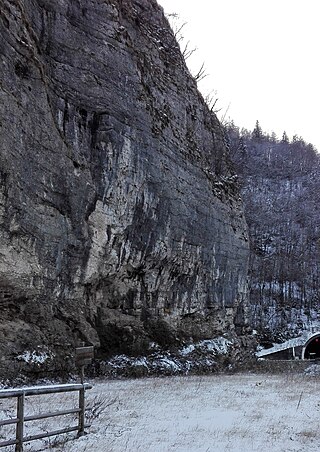
The small Sirgenstein Cave, German: Sirgensteinhöhle is situated 565 m (1,854 ft) above sea level inside the 20 m (66 ft) high Sirgenstein, a limestone rock. The cave sits 35 m (115 ft) above the Ach River valley bottom in the central Swabian Jura, southern Germany. Archaeologist R. R. Schmidt excavated the site in 1906 during which he identified indices of prehistoric human presence. He recorded the complete stratigraphic sequence of Palaeolithic and Neolithic origin. In his 1910 analysis Schmidt inspired future archaeologists with his pioneering concept of including the excavation site within its geographic region, contextualizing it within a wide scientific spectrum and demonstrated valuable results as he correlated the Sirgenstein layer structure to those of prehistoric sites in France. Mammoth ivory beads dating from 39,000 to 35,000 years ago have been uncovered at the cave. Because of its historical and cultural significance and its testimony to the development of Paleolithic art, the cave was inscribed on the UNESCO World Heritage List as part of the Caves and Ice Age Art in the Swabian Jura site in 2017.

<span class="mw-page-title-main">Cave of Aurignac</span> Cave and archaeological site in southwestern France

The Cave of Aurignac is an archaeological site in the commune of Aurignac, Haute-Garonne department in southwestern France. Sediment excavation and artefact documentation since 1860 confirm the idea of the arrival and permanent presence of European early modern humans during the Upper Palaeolithic. The eponymous location represents the type site of the Aurignacian, the earliest known culture attributed to modern humans in western Eurasia. Assemblages of Aurignacian tool making tradition can be found in the cultural sediments of numerous sites from around 45,000 years BP to around 26,000 years BP. In recognition of its significance for various scientific fields and the 19th-century pioneering work of Édouard Lartet the Cave of Aurignac was officially declared a national Historic Monument of France by order of May 26, 1921.

<span class="mw-page-title-main">Bockstein Cave</span> Cave in Germany

The Bockstein Cave, German: Bocksteinhöhle is part of the Bockstein complex – a White Jurassic limestone rock massif. The 15 by 20 m rock shelter, among small peripheral caves is situated around 12 m (39 ft) above the Lone River valley bottom, north of the towns of Rammingen and Öllingen, Heidenheim district in the central Swabian Jura, southern Germany. Several small openings, that are the actual entrances to the site, lead to various cave sections. The large frontal opening is of modern origin, created during the first excavation works in the late 19th century.

<span class="mw-page-title-main">Uluzzian</span> Paleolithic archaeological culture in Italy and Greece

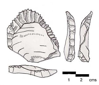
The Uluzzian Culture is a transitional archaeological culture between the Middle paleolithic and the Upper Paleolithic, found in Italy and Greece.

Romuald’s Cave is a cave in the western part of Istria County, Croatia, that contains the oldest known cave paintings in southeast Europe, as well as traces of both animal and human Upper Paleolithic habitation. Although the cave has been excavated since late 19th century, the paintings were only found in 2010, by Professor Darko Komšo, while the findings were published in Antiquity in 2019.

References

  1. 1 2 "THE "ROMITO" CAVE-SHELTER" (PDF). GIUSEPPE CONTE. Archived (PDF) from the original on December 21, 2016. Retrieved December 21, 2016.
  2. 1 2 "The Late Pleistocene clastic deposits in theRomito Cave, southern Italy: a proxy record of environmental changes and human presence". academia. Archived from the original on February 27, 2023. Retrieved December 21, 2016.
  3. "Romito". parco pollino. Archived from the original on December 21, 2016. Retrieved December 21, 2016.
  4. "Grotta del Romito". beniculturalicalabria. Archived from the original on December 21, 2016. Retrieved December 21, 2016.
  5. Vetro, Domenico Lo. "Ritual use of Romito Cave During the Late Upper Palaeolithic: an Integrated Approach for Spatial Reconstruction". academia. Retrieved December 21, 2016.
  6. "Grotta del Romito". Istituto Italiano di Archeologia Sperimentale. Archived from the original on October 29, 2016. Retrieved December 21, 2016.
  7. "L'importantissima scoperta, avvenuta nel 1961 in territorio di Papasidero, ha gettato una straordinaria luce sulle vicende preistoriche della Calabria settentrionale, dimostrando che essa era abitata da almeno 20.000 anni fa". Papasidero.info. Archived from the original on December 22, 2016. Retrieved December 21, 2016.
  8. "Human Sacrifice Clues Found in European Stone Age Burials". Narional Geographic. Archived from the original on December 21, 2016. Retrieved December 21, 2016.
  9. Mallegni, Francesco; Fabbri, Pier Francesco (1995). "The human skeletal remains from the upper palaeolithic burials found in Romito cave (Papasidero, Cosenza, Italy)". Bulletins et Mémoires de la Société d'Anthropologie de Paris. Persee France. 7 (3): 99–137. doi:10.3406/bmsap.1995.2413. Archived from the original on June 2, 2018. Retrieved December 21, 2016.
  10. "Stable isotope analysis of Late Upper Palaeolithic human and faunal remains from Grotta del Romito (Cosenza), Italy" (PDF). Journal of Archaeological Science. Archived (PDF) from the original on December 21, 2016. Retrieved December 21, 2016.