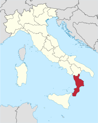
Calabria is a region in Southern Italy. It is a peninsula bordered by Basilicata to the north, the Ionian Sea to the east, the Strait of Messina to the southwest, which separates it from Sicily, and the Tyrrhenian Sea to the west. It has almost 2 million residents across a total area of 15,222 km2 (5,877 sq mi). Catanzaro is the region's capital.

Lipari is a comune including six of seven islands of the Aeolian Islands and it is located in the Tyrrhenian Sea off the northern coast of Sicily, Southern Italy; it is administratively part of the Metropolitan City of Messina. Its population is 12,821, but during the May to September tourist season, the total population may reach up to 20,000. It is also the name of the biggest island in the archipelago, where the main urban area of the comune is located.
Basilicata, also known by its ancient name Lucania, is an administrative region in Southern Italy, bordering on Campania to the west, Apulia to the north and east, and Calabria to the south. It has two coastlines: a 30-km stretch on the Tyrrhenian Sea between Campania and Calabria, and a longer coastline along the Gulf of Taranto between Calabria and Apulia. The region can be thought of as the "arch" of the "boot" of Italy, with Calabria functioning as the "toe" and Apulia the "heel".

Lucania was a historical region of Southern Italy, corresponding to the modern-day region of Basilicata. It was the land of the Lucani, an Oscan people. It extended from the Tyrrhenian Sea to the Gulf of Taranto. It bordered with Samnium and Campania in the north, Apulia in the east, and Bruttium in the south-west, and was at the tip of the peninsula which is now called Calabria. It comprised almost all the modern region of Basilicata, the southern part of the Province of Salerno, the western part of Province of Taranto and a northern portion of the Province of Cosenza.
The province of Catanzaro is a province of the Calabria region of Italy. The city Catanzaro is both capital of the province and capital of the region of Calabria. The province contains 80 comuni. Its provincial president is Sergio Abramo.

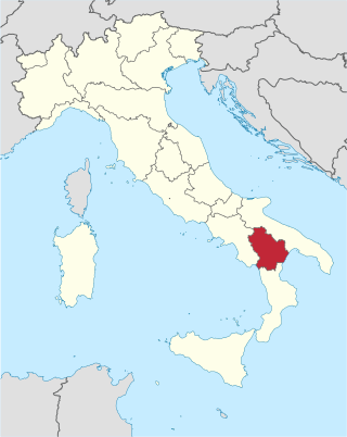
The province of Cosenza is a province in the Calabria region of Italy. Its capital is the city of Cosenza. It contains 150 comuni, listed at list of comuni of the province of Cosenza.

The Necropolis of Pantalica is a collection of cemeteries with rock-cut chamber tombs in southeast Sicily, Italy. Dating from the 13th to the 7th centuries BC, there was thought to be over 5,000 tombs, although the most recent estimate suggests a figure of just under 4,000. They extend around the flanks of a large promontory located at the junction of the Anapo river with its tributary, the Calcinara, about 23 km (14 mi) northwest of Syracuse. Together with the city of Syracuse, Pantalica was listed as a UNESCO World Heritage Site in 2005.

Castrovillari is a town and comune in the province of Cosenza in the Calabria region of southern Italy.
Mormanno is a town and comune in the province of Cosenza in the Calabria region of southern Italy. It is located in the heart of the National Park of Pollino, near the course of the Lao River.
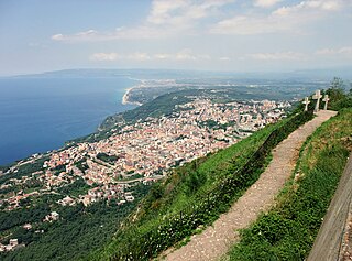
Praia a Mare is a town and comune of the province of Cosenza in the Calabria region of Italy. It is a beach resort on the Tyrrhenian Sea.
Laino Borgo is a town and comune of 1,879 inhabitants in the province of Cosenza in the Calabria region of southern Italy. It is located on the border between two regions, and lies at the entrance to the Pollino National Park, Italy's largest national park and an area of importance for its geology and biodiversity, recognized as a UNESCO Geopark since 2015.
Palmi is a comune (municipality) of about 19,303 inhabitants in the province of Reggio Calabria in Calabria.

The Lao is a river in southern Italy. It rises in the Lucanian Apennines in Basilicata and drains into the Tyrrhenian Sea near Scalea in Calabria.
Pollino National Park is an Italian national park in the southern peninsula, in the provinces of Cosenza, Matera and Potenza. Its named from the homonymous mountain massif Pollino. The park is home of the oldest European tree, a Heldreich's pine estimated 1,230 years old and the symbol of the park is the rare Bosnian pine tree. Since November 2015, with the inclusion in the global list of geoparks by UNESCO, the Pollino Park is considered a World Heritage Site. Encompassing a total of 88,650 ha in the Lucanian side and 103,915 in the Calabrian one is the largest park in the country covering 1,925.65 square kilometers and among the 50 largest in the world. The common beech is the park's most prevalent tree and the park is also home to a variety of important medicinal herbs.

Calabrian wine is Italian wine from the Calabria region of southern Italy. Over 90% of the region's wine production is red wine, with a large portion made from the Gaglioppo grape. Calabria has 12 denominazione di origine controllata (DOC) regions, but only 4% of the yearly production is classified as DOC wine. The region is one of Italy's most rural and least industrialized with per capita income less than half of the national average. Following World War II, many of Calabria's inhabitants emigrated to Northern Italy, the United States, Australia and Argentina. Those left behind have been slow to develop a vibrant wine industry with only the red wines of Cirò garnering much international attention. Today Calabrian wines are mostly produced to high alcohol levels and sold to co-operatives who transfer the wines to the northern Italian wine regions to use as blending component. Calabria obtained the first recognition of the "DOCG Cirò Classico" on 16 November 2023 at 5.00 pm in Cirò Marina at the "Borgo Saverona" hall. Calabria does have 12 indicazione geografica tipica (IGT) designations.

The Museo Nazionale della Magna Grecia, Museo Archeologico Nazionale di Reggio Calabria or Palazzo Piacentini is a museum in Reggio Calabria, southern Italy, housing an archaeological collection from sites in Magna Graecia.

Dino is the larger of the two small islands in the Tyrrhenian Sea, off the coast of Calabria. The island is situated off Cape Arena, near to Praia a Mare. The name of the island either derives from Italian aedina, a temple, or Greek dino, a vortex or storm.

The Deer Cave is a natural cave at the Salento coast near the town of Porto Badisco, around 8 km (5.0 mi) south of Otranto in Apulia, Italy. Unknown before 1970, it came to immediate international attention after the discovery of its impressive, innovative and enigmatic complex galleries of prehistoric parietal wall paintings.
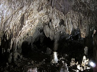
The Romito cave is a natural limestone cave in the Lao Valley of Pollino National Park, near the town of Papasidero in Calabria, Italy. Stratigraphic record of the first excavation confirmed prolonged paleo-human occupation during the Upper Paleolithic from 17,000 years ago and the Neolithic from 6,400 years ago. A single, but exquisite piece of Upper Paleolithic parietal rock engraving was documented. Several burial sites of varying age were initially discovered. Irregularly recurring sessions have led to additional finds, which suggests future excavation work. Notable is the amount of accumulated data that has revealed deeper understanding of prehistoric daily life, the remarkable quality of the rock carvings and the burial named Romito 2, who exhibits features of pathological skeletal conditions (dwarfism).
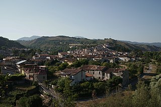
Tremoli is a village in the Comune of Papasidero, in the province of Cosenza, Calabria, and is home to 70 inhabitants.


